Documenting solution proposals for `highway=path`

Update: the work-in-progress on the path sub-types is being summarized in the second post (Documenting solution proposals for `highway=path` - #2 by _MisterY).


As a follow-up to Documenting the problems with `highway=path`, I will open the topic of listing the solution proposals for the highway=path issues.
The first post(s) will be wiki entries so please feel free to add references.

The idea here is to list (and add) concrete proposals that solve various aspects and issues in the Path discussions. I don’t think many of those mentioned in the discussions are ready for an official proposal or a vote but this way we can narrow them down.

Earlier, a poll has turned up some possible solutions, giving an impression of the level of consensus at that time: History of proposals to fix highway=path ambiguity – and a wayforward? - #140 by julcnx

The proposals are below.

Trail Difficulty

  1. Reference: Trail difficulty rating system - Wikipedia
  2. Adding T0/strolling to sac_scale - :white_check_mark: implemented

Examples from Other Maps

  1. Ă–AV cartography, Alpinist routes marked as footpaths - #117 by Hungerburg
  2. Swisstopo, Ă–K50, IGN 25, DGK: Introduce Pathless / Alpine Path / Off-Path? - #76 by Road_Runner
  3. Alpinist routes marked as footpaths - #122 by osmuser63783
  4. Alpinist routes marked as footpaths - #124 by Minh_Nguyen
  5. Alpinist routes marked as footpaths - #126 by ezekielf
  6. Useful Maps
  7. Documenting solution proposals for `highway=path` - #101 by Hungerburg
  8. https://support.alpenvereinaktiv.com/space/AVAKTIV/27230237/Legenden+zu+den+Karten

New Highway Tags

  1. RfC: Highway=Scramble
  2. RFC: Highway=Mountaineering
  3. RfC: Highway=bootprints

New Sub-Tags

  1. Introduce Pathless / Alpine Path / Off-Path? - #30 by supsup
  2. Discussion about deleting the highway samples page - #18 by _MisterY

introduce pathway=*

  1. Pathway=* for ways not used by or intended for cars

add path=* subtypes

  1. History of proposals to fix highway=path ambiguity – and a wayforward? - #181 by Peter_Elderson

Create new subtype tags (e.g. path=* ) that are intended to be used with highway=path which further classify the path and provide more precise characterization. This method preserves the current support and interpretation of highway=path by data consumers and provides a gradual path forward.

There is some use for path=climbing_access, which marks approach paths for climbing routes.
https://taginfo.openstreetmap.org/tags/path=climbing_access

Other

  1. Documenting the problems with `highway=path` - #46 by Pypes
  2. RfC: Have pathless hiking routes (no trail_visibility) be some manner of related nodes instead of paths

Historical Entries

What about routes in pathless terrain?

Do we need more difficulty keys?

Ideas for more difficulty keys

6 Likes

This is a work-in-progress for the proposal on the sub-division of highway=path.
Discussions are continuing in this thread, mainly.

The base is Pathway=* for ways not used by or intended for cars, which contains most of the narrative with the history and explanation. This is expanded with types found in the legend at Alpinist routes marked as footpaths - #117 by Hungerburg.
(TBD used bellow means “to be determined” after discussion.)

Naming

As it seems that there is not much support for the path sub-types to be included in the highway=* tag and thus effectively deprecating highway=path straight away, a new tag would be used for subdivision. TBD: This would be path=* or pathway=*. Over time, this could turn into the primary tag by dropping highway=pathfrom ways withpath=*`.

The main distinction between highway=* and path=* is that cars can use highways but not paths. Secondary distinctinos is that virtually all highways above track are built. On the other hand, paths are usually not built/contructed. There are exceptions to this: there are built paths in urban areas (for example ways shared by bikes and pedestrians in parks or alongside roads) or in highly managed rural or natural areas (in national parks or non-car links connecting urban areas. Unbuilt paths follow the terrain, were created by people repeatadly treading the same trajectory and may contain “interventions” like ladders and steps.

Question of requirements

TBD: It is not clear whether the proposal would state that a pathway/path subtag is required for highway=path (similar like subtag is required for tourism=information).

Values

The values would be:

  • “Karrenweg” Working name. TBD: some name suggestions: track, single-track, multi_use, motorcyclefootway, all_but_cars, two_wheels, carless, cartwheel, multi-use single track:
    • Suitable for wheeled traffic but either narrower than a highway=track. TBD: It may additionally include paths where cars are legally banned but would otherwise fit.
    • Paths where motorcycles and (road) bicycles can be used with ease, both legally and practically, but also carts, carriages, wheelbarrows, quads, horses etc.
    • Exceptions to legal access can be marked with for example motorcycle=no.
    • Should not overlap with shared_use, highway=cycleway, mtb_single_track.
    • TBD: Conceivably could be broken alongside the built/unbuilt distinction (then the main difference would be whether they are well-usable during rain), but probably not needed.
    • German name for this is “karrenweg”
  • trail (also suggested: path)
    • Not generally practically suitable for vehicle traffic but suitable for pedestrians.
    • Legal access undetermined. Both trails where technically anything is legally permitted and trails that are allowed only for pedestrians are admissible. This would make explicit that unconstructed highway=footway should be tagged as trail.
    • These are mostly unbuilt. Built ones fall under highway=footway. Some lightweight maintanance like pruning vegetation and preventing erosion is fine.
    • TBD: Can be divided into two subsets:
      • easy_trail, wide_trail This is easy, allows for safe passing of people (even if they have to leave the trail itself).
      • difficult_trail, narrow_trail Appropriate for only one person at a time. Too narrow for two persons to pass each other comfortably and safely. More demanding than easy_trail.
  • traces Path that is barely discernible on the ground. Only trace(s) or markers visible.
  • trackless (?), pathless, off-trail, cross_country,terrain: Path not visible on the ground but terrain suitable (at least) for pedestrian traffic

All of the above are encouraged but not required to have sac_scale (and possibly horse_scale and mtb_scale) specified. Also trail_visibility is recommended, though for difficult_trail and up, at least trail_visibility=good is the norm (which can have exceptions). traces ranges between intermediate to horrible. pathless is bad and below.

Specialized:

  • mtb_single_track, downhill_trail. For MTB (downhill).
    • This is for ways specifically designed and meant for people on mountain bikes. That means they are usually modified to make the ride more pleasurable.
    • Legally they do not need to be exclusive to bikes, but in practice, either by social norm, their position in the path network, signage, or their unsuitability (or even danger stemming from dense downhill trafific) for pedestrians means overwhelmingly people on mountain bikes use them.
    • They need not be enclosed in some compound and they can be either for free or paid.
    • They are usually managed, either formally or very informally (i.e. somebody built a MTB-specific trail guerrilla-style).
    • mtb_scale is highly recommended.
  • shared_use
    • Ways that are legally meant to be shared by cyclicsts and pedestrians (byt not motorcycles and other vehicles).
    • Currently mapped as highway=path;bicycle=desiganted;foot=designated (TBD: this tagging should probably over time be deprecated in favour of this tag.).
    • Described here: Shared-use path - Wikipedia
  • snowmobile
    • Either only existing in winter (when they then should be somewhat observable by snowmobile traces) or signed all-year-round but impractical in summer.
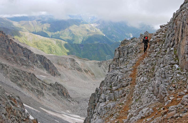
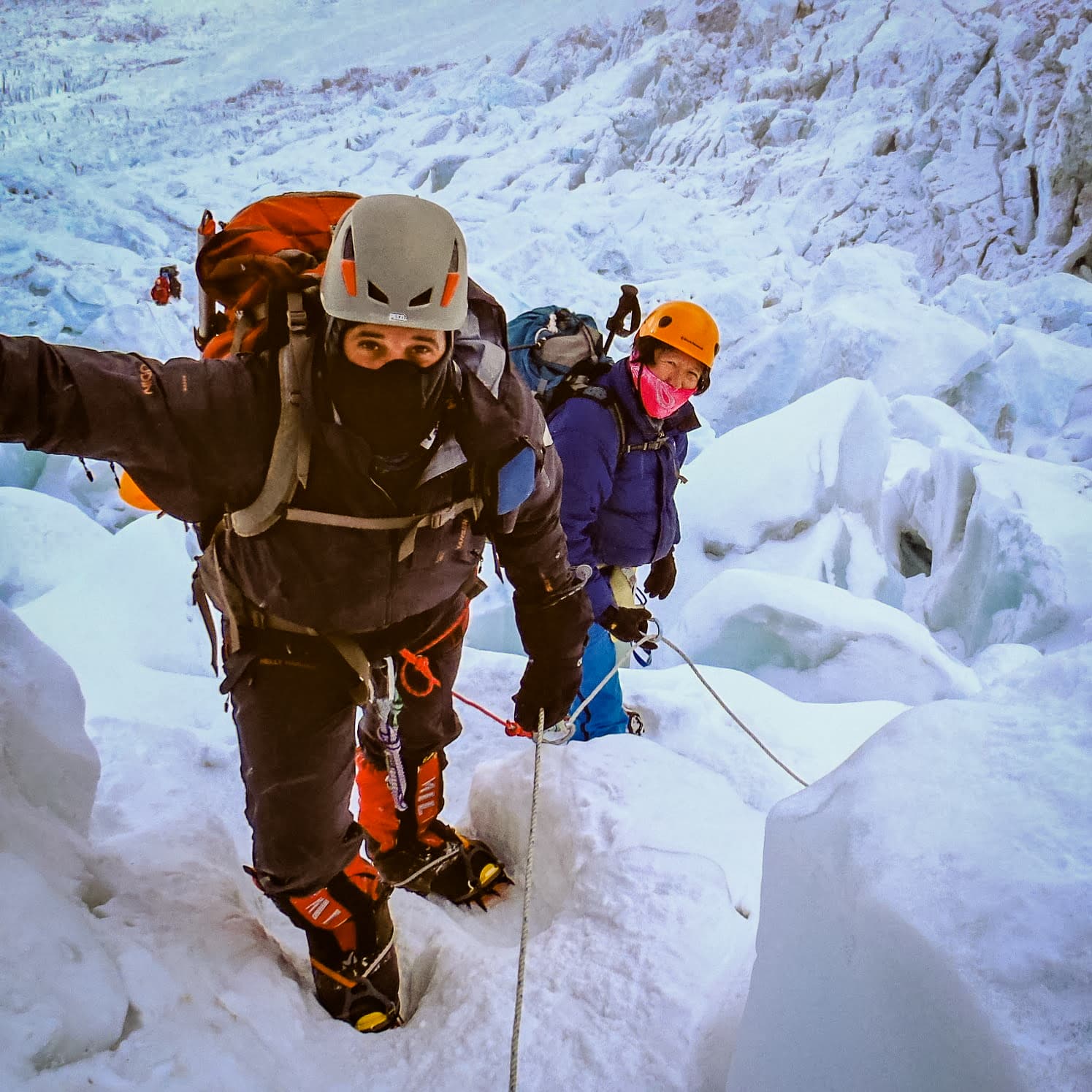
  • mountaneering (in search of possbily better name)
    • Outside of current scope of highway=path, meaning they are harder than sac_scale=diffficult_alpine_hiking.
    • Estabilished routes, for example to Mt. Everest, Manaslu (but this is not specific to Himalayas), or Matterhorn.
    • Only routes where one would be likely to meet people when the season and weather is good should be included, by far not all mountaneering routes ever undertaken should be put in.
    • Typically need mountaneering equipment like crampons, ropes etc.
    • Should never be combined with highway=path.
    • Typically leads to a major summit. Sport_climbing routes that people climb mainly for the joy of overcoming difficulties (in climbing shoes, strictly on rope, usually without crampons) are covered by Climbing - OpenStreetMap Wiki

TBD: Ways conceptually today under highway= or other keys that can either stay there or migrate to path/pathway (ideally, they have no overlap with the new tags):

  • via_ferrata
  • ladder
  • steps
  • footway
  • cycleway
  • bridleway
  • golf=golf_cart

The last one:

  • unknown or yes Ways under path but whose detailed classification is unknown.
    • Especially if the requirement for adding secondary tag to highway=path is adopted, this would indicate a new path whose further classification is unknown for some reason.
    • Would basically be a specific fixme.
    • Akin to existing highway=road.
    • Would facilitate moving over from highway=path as it would help to distinguish newly added unknown paths from older not-yet-retagged highway=paths.

Examples

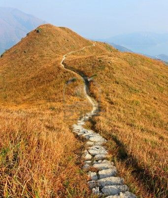
karrenweg (single_track, multi_use, carless, etc.)


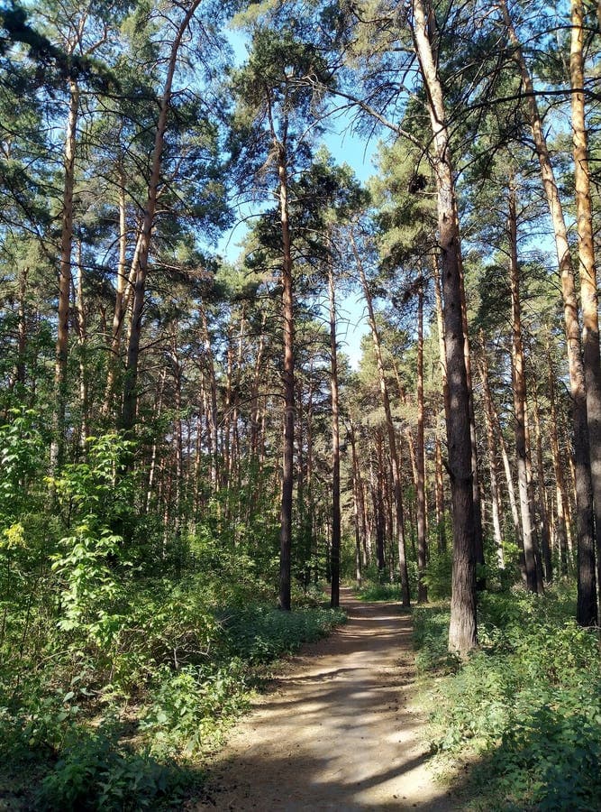
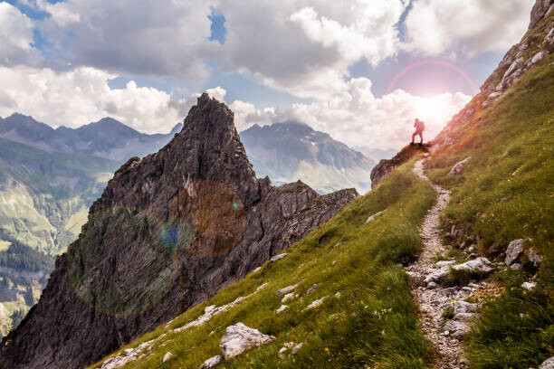
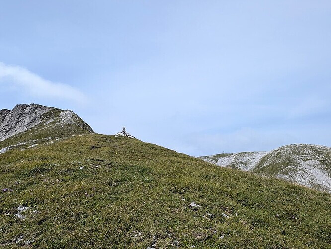
Trail, easy_trail, wide_trail


image

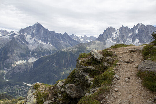
Trail, difficult_trail, narrow_trail


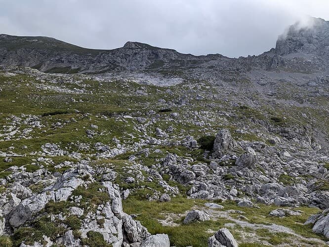
Presence of obstacles on the side makes this one a narrow path:
image

Trail, disputed whether easy_trail or difficult_trail


image

Trace
image
image
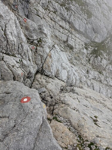
(the rock stairs are the trace:)

Pathless, no visible traces or markers on a way but terrain suitable for crossing on foot


image

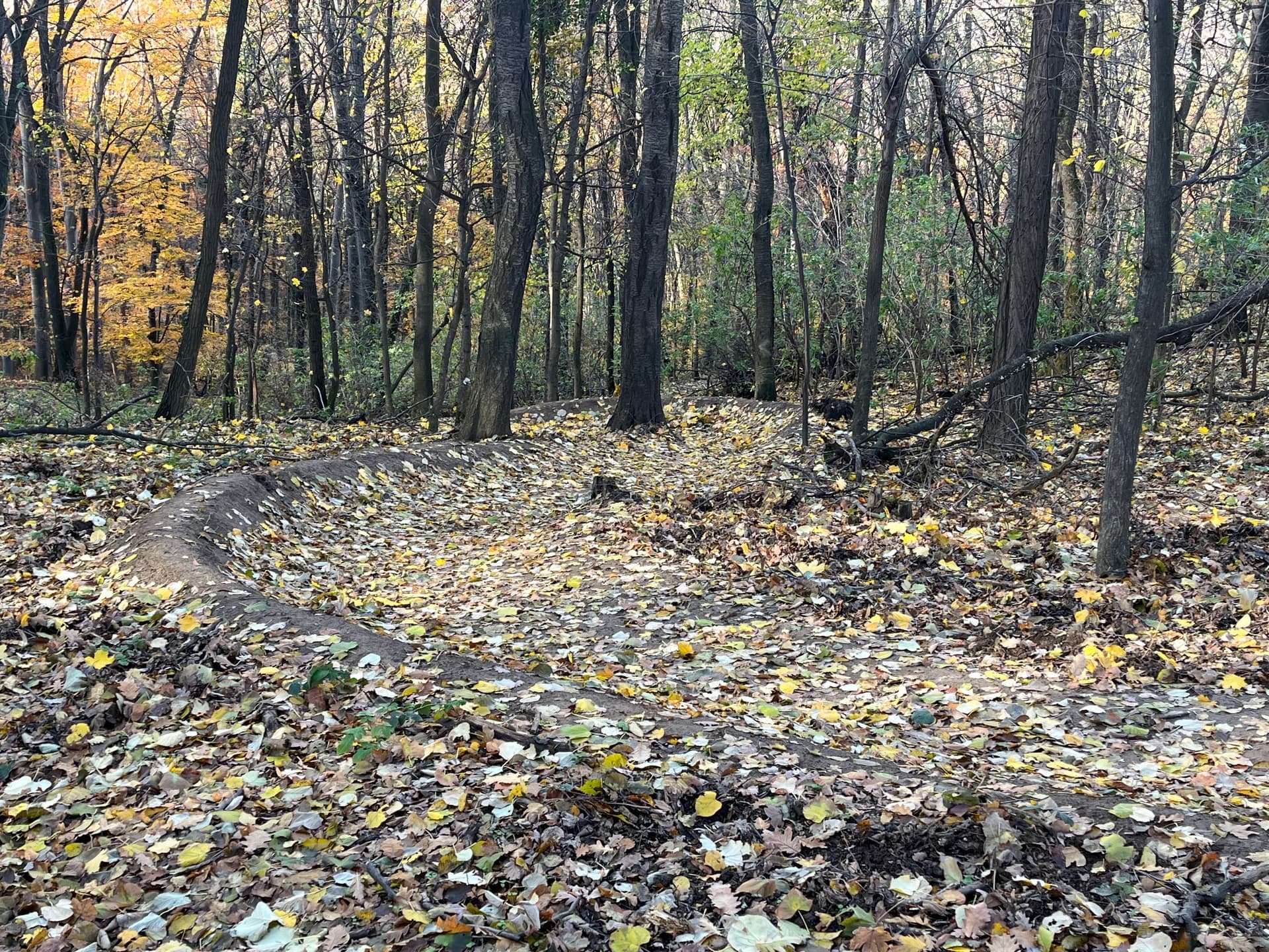
MTB trail (mtb_single_track), notice the constructed curved wall made specifically to easy going through the curve at speed on a mountain bike

A trail (easy_trail) next a MTB trail pictured above (on the right you can see the constructed bum described above`)

Other examples of mtb_single_track


Single_Track
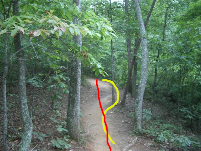
A pedestrian would most comfortably walk along the red line. For a biker going downill, momentum makes the yellow line more logical and enjoyable (the difference is faint but discernible here).

mountaineering (only the first photo one has a license that makes it ok for the wiki)


Schlange-Manaslu_MingmaDavi-300x225

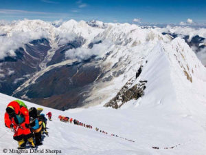
Existing OSM ways that would be tagged with mountaneering

In this post I’ll try to summarize (and keep up-to-date) what solution I personally would like to have.

highway/pathway=climbing instead of scramble and the likes.
Scramble is a subset, anyway, as it covers lower UIAA grades. Free climbing does not use equipment to advance but for protection only. That said, some people also climb without equipment even on higher grades (free solo). If you don’t count shoes into specialized equipment, that is.

highway=path remains for nature trails / hiking paths.

Grading system for difficulty.
Background: Trail difficulty rating system - Wikipedia
Some sort of simplified system with not that many grades. Probably 3 grades are enough, since path would be used only for actual paths and walking/hiking.

As I have voted before, eg climbing= can be used directly. There’s no need to use highway=, invent another pathway= , or argue about “climbing” vs scrambling for the categorization.

One of the solutions was to use path=* for a limited set of prototype paths.

How exactly is it supposed to be used? What would that tag be added to? A path?

Edit:
Oh! I found

and now it all makes sense! Austria seems empty, not for the lack of crags but for the mess with the tags. No wonder I was confused.
Thanks for the tip! A lot of work ahead on adding sites/crags/routes with topos.

Do you have a link that elaborates more? If not, please feel free to add to the first post / wiki entry directly.

Option 2:

Create new subtype tags (e.g. path=*) that are intended to be used with highway=path which further classify the path and provide more precise characterization. This method preserves the current support and interpretation of highway=path by data consumers and provides a gradual path forward (with the risk of [legacy/simple/…] data consumers not parsing these new sub-tags and interpreting highway=path as they currently do).

What these proposals seem to have in common is that because highway=path is considered too “general”, they move detail from a lower-level tag up to the key value or even the key itself (by splitting off pathway=* from highway=*).
Looking at the “bad” end of highway=path, highway=scramble and highway=mountaineering are adding the detail “this is a difficult path” to highway=path that highway=path + sac_scale=* can tell in much more detail (6 and hopefully soon 7 levels of detail). This thread similarly proposed new tags for pathless paths to express what highway=path + trail_visibility=no is also expressing.

When we try to express such information in first level tag values, we loose detail; if we want to prevent loosing that detail, we would have to introduce many more tag values. What would you call a path that’s quite difficult and not very visible, that you could also tag with highway=path + sac_scale=demanding_mountain_hiking + trail_visibility=intermediate? We would need 7*6=42 different first level tag values to express the same detail that highway=path + sac_scale=* + trail_visibility=* can. And we would need to survey the path and decide on its difficulty and visibility first before we can map it.

I don’t think we should go this way.

2 Likes

That’s one way to look at it. Another would be:

A highway=path is suitable for use by pedestrians, bicyclists, and horse riders. If either is not allowed, we show this with access tags. Neither a scramble nor a mountaineering “path” are suitable for bicyclists or horse riders, so they shouldn’t be tagged as a highway=path.

3 Likes

This is a false dillemma. Nobody wants to abolish those secondary tags. They would still be useful. The same way we still have surface for those 21 (I am told) highway= values for roads for cars.

It would just allow consumers to be lazier about stuff they do not care about. I can imagine a hiking map would render path and scramble and pathless the same way if they all had trail_visibility and sac_scale set. However, if they did not or for a consumer not interested in hiking, there would be better defaults or easier way for them not to show such pathways at all.

7 Likes

That’s how it’s done best. Mapping a path without been on it, seriously?
I did it one time, turns out there was nothing left but bushes.

1 Like

The car argument has been raised already. I’ll just illustrate a bit further.
A path, 20m wide, asphalt, 6 lanes, one-way, car=designated, no bicycles, no pedestrians, fee, good visibility, low inclination. Oh, wait, that’s a motorway, isn’t it?
Everything can be described with secondary tags. We just need lines, they don’t even need to be paths. Maybe they are rivers? It should be clear from another few dozen secondary tags.

I’m pretty sure there’s less difference between several types of roads (primary, secondary, anyone?) than there is between different types of paths. I mean, you have for sure seen the images at

We certainly don’t need main tags for everything. But what are the criteria?
I agree that, at the moment, we are mixing the visibility with surface, with width and inclination, and trying to add some sort of difficulty scale (7 levels?! That is way too many!) in the new tag names.
Let’s then try to come up with some sensible criteria to apply. We all can instinctively tell that there’s a big difference between a stroll path next to a river and an UIAA level III scramble. But we seem unable to define it properly.

Literally no-one is suggesting that.

4 Likes

It seems your “Documenting” thread has become yet another discussion thread. A sprawling topic where no-one can keep an overview.

Presumably OP has some semblance of overview, so If OP could sum up the stated problem(s) in some bullet points (in the first post), and then list the concrete (viable) solution suggestions.

1 Like

That’s the purpose of a thread in a public forum. :wink:

It looks like you haven’t even read the original post. All this is explained there. The solutions are placed in the first post, which is a wiki entry that everyone can edit. I add what I run into but others can and should link or write down what they think solves some of the problems. The problems are documented in a separate, linked, thread. Again, as a wiki containing links to numerous posts, threads, and articles that explain it in more detail.

People are, of course, welcome to provide thoughts and opinions. That is what this is all about. We all learn something and can adapt the system better (hopefully).

I take your point, but the post is a list of links to other discussions with many replies in them :slight_smile:. That’s why I was looking for some kind of summary from someone who’s read them all already. I am interested in seeing a result on the topic of path. I hope something comes of it. :crossed_fingers: :shamrock:

1 Like

Understandable. I think we’re still a couple of steps behind that. I wanted to try to narrow down to it. The suggestions are many. Some are not concrete proposals and I’m not sure if even their authors still hold those opinions after all the discussions. That’s why perhaps it would be useful to put as many, discuss them again, and keep narrowing and improving the list of solutions.

I.e. there’s a point in the statement that a line could, at the same time, be pathless, and a scramble, and a mountaineering route, and perhaps an easy climbing route.
That, however, is no different to a path that is a walking path and a cycling path at the same time. So, that discussion will be interested to follow at the moment.

I think the main post will keep improving as the suggestions come in.

Edit: link

The more detailed first-level values for paths we have are distinct by the legal access limitations they imply (a highway=footway is a path legally designated for pedestrians, etc.). This can be determined easily, because an access limitation is there or not there (there is a sign or not, a law or not, etc.). For paths with 1 access limitation, we have more detailed tag values, while for paths with no or more than 1 access limitation (combined cycle&foot paths) we have only highway=path that fits. This can’t be done for suitability, because suitability exists in many shades of gray. What is suitable for one person and transportation mode may not be suitable for another, depending on skills, level of preparation, etc. That’s what we have our rating systems for: they provide information that helps an individual to decide for himself whether a way is suitable for him/her.

I think the main driver for wanting to distinguish “bad” paths from normal “suitable” paths is safety. We don’t want map users to end up in trouble and having to be rescued because they used a path that’s not suitable for them. We could do that by deciding which level of difficulty of a path is no longer suitable and safe for the general public, and tag paths that are more difficult with a different tag value. We may decide that paths more difficult than sac_scale=mountain_hiking are unsafe for the general public, and tag them highway=mountaineering. Or we may have a bit more confidence in their skills, and tag paths more difficult than sac_scale=demanding_mountain_hiking as highway=scramble. I foresee a long discussion on what the cut off value should be…

I am wondering how that would work out in practice. Suppose you are armchair mapping, and see what looks like a path on satellite imagery that’s in the mountains, goes through what looks like a rocky area, and is quite steep on the topo map. How would you map such a path? How would you determine if it’s beyond the cut off value we agreed, or not? You may decide that such paths shouldn’t be mapped at all until surveyed. And that paths shouldn’t be armchair-mapped at all, because there’s always the risk that an easy-looking path contains a 5m rappel down that doesn’t show on any image or topo map. So you would only map it after a survey. Suppose the survey shows that the path is sac_scale=demanding_mountain_hiking, so you could map it as highway=scramble. But then why not map it as highway=path + sac_scale=demanding_mountain_hiking? This carries more information, because it shows it’s a scramble, but an easy one. So what’s the need for having highway=scramble, then?

Well, but that’s exactly how it works with roads: a road too narrow for a car is a path, because it’s unsuited for cars. Same goes for sidewalks: A sidewalk with 20cm width is not a sidewalk.

And that’s exactly why more top-level highway-tags would help here.

We certainly don’t, no.

Um … not at all hopefully :laughing:

1 Like