NL verderop / IT più in basso // 日本語訳は以下に / ES más abajo / RU далее / 中文翻译再往下
EN
TL;DR: Please send examples of wayside shrines and wayside chapels.
History of `historic=wayside_chapel` (click to expand)
historic=wayside_chapel began being used between 2008 and 2012. It was only documented in the wiki in 2019, and even then it did not have a clear definition. Especially the difference with historic=wayside_shrine was unclear. It was marked as deprecated a month later already. Some mappers objected to that on the talk page.
There was a sharp drop in usage near the beginning of 2022, which suggests a mechanical edit. With some historical Overpass digging, I see that the edit was centred around Austria; chapels were just retagged from historic=wayside_chapel to the (also undocumented) place_of_worship=wayside_chapel (usage over time).
Need for tagging (click to expand)
Despite being deprecated, historic=wayside_chapel remains in fairly widespread use in Belgium (which has a strong wayside chapel culture) and Central Europe. There is also a (non-OSM) website mapping all the wayside chapels in Flanders (part of Belgium). This demonstrates the interest in these and the need for better tagging.
I propose to leave historic=wayside_chapel deprecated. (Undefined tags are bad, and defining a tag that’s already in use is not a good idea either.)
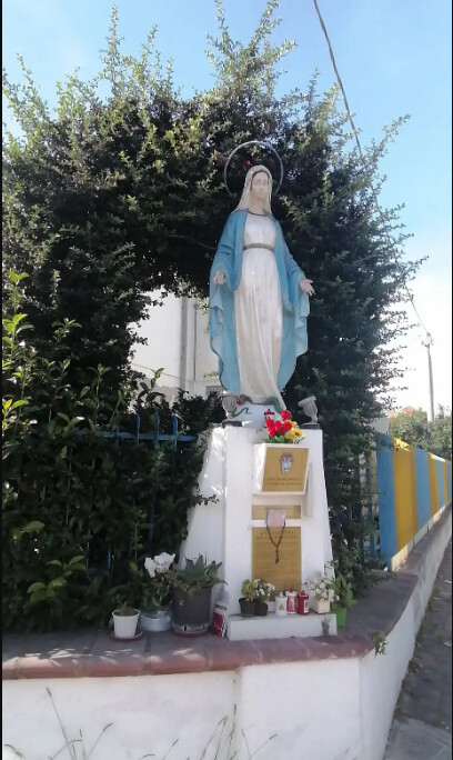
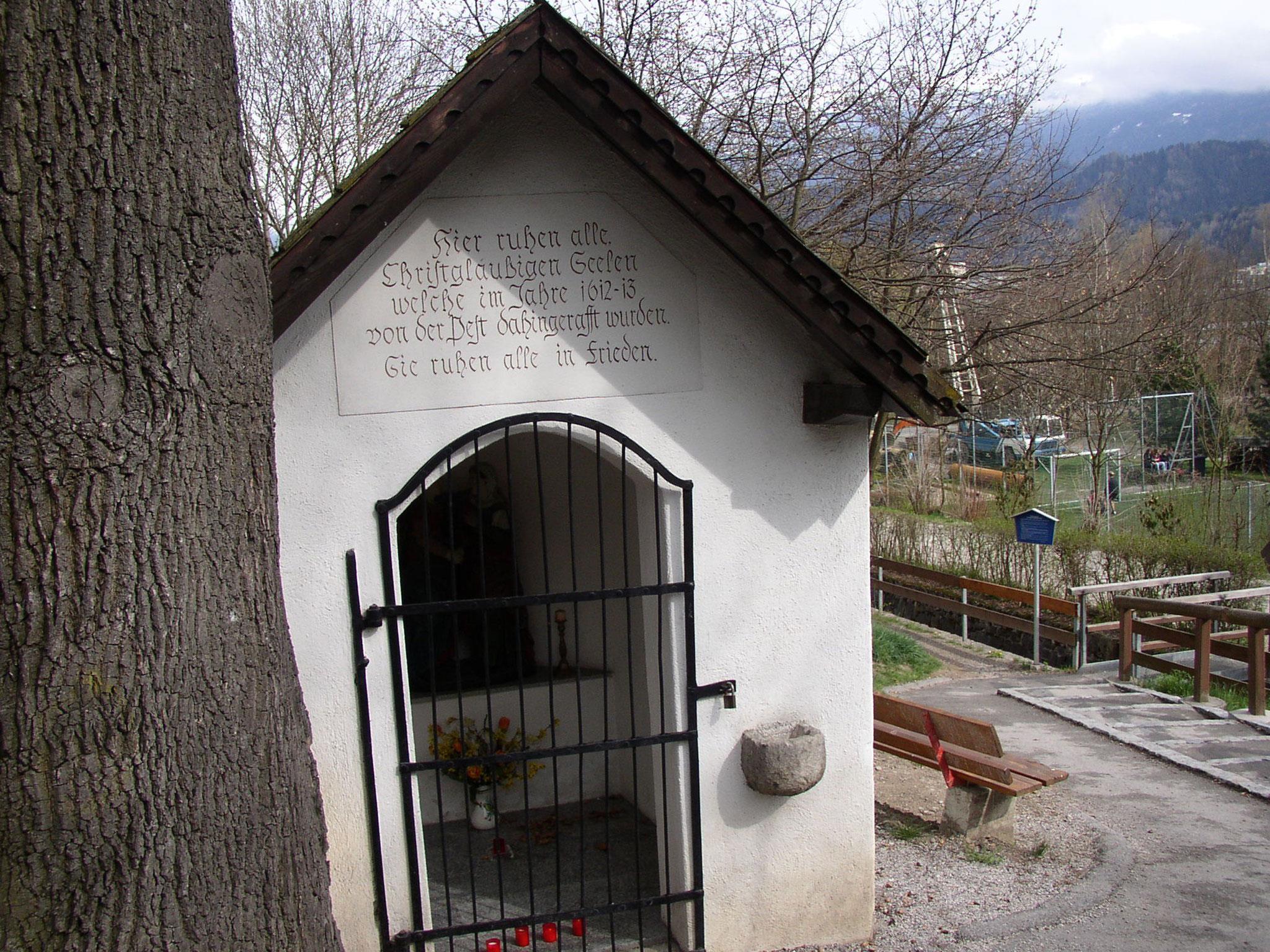
To differentiate between different types of wayside spiritual structures, I would rather create new tagging (maybe reuse historic=wayside_shrine, we’ll see about that later). To get a good idea of what categories and properties we would like to map, I’d first like to collect photos of different types in different cultures.
If you share photos, provide some information if possible: where the structure is located, which religion it is for, how you would call this type of structure, a description of this type of structure, and any properties you’d like to map about it.
To be clear: in my book, a wayside spiritual object is a structure
- that is meant to inspire spiritual or religious ideas
- that not many people specifically go to; i.e. it’s primarily aimed at passers-by.
NL
Samenvatting: Stuur voorbeelden van wegschrijnen en wegkapelletjes in andere culturen.
Geschiedenis van `historic=wayside_chapel` (klik om te openen)
historic=wayside_chapel begon gebruikt te worden tussen 2008 en 2012. Pas in 2019 kwam er documentatie in de wiki, en zelfs toen was er geen duidelijke definitie. Vooral het verschil met historic=wayside_shrine was vaag. Een maand later werd de tag al gemarkeerd als afgevoerd. Sommige mappers gingen daar niet mee akkoord op de overlegpagina.
Er was een scherpe daling in gebruik aan het begin van 2022, wat lijkt te wijzen op een mechanische bewerking. Met wat historisch graafwerk in Overpass zie ik dat de bewerking gecentreerd was rond Oostenrijk; kapellen werden gewoon hertagd van historic=wayside_chapel naar de (eveneens niet gedocumenteerde) place_of_worship=wayside_chapel (chronologie van gebruik).
Tagging is nodig (klik om te openen)
Ondanks de afvoering, blijft historic=wayside_chapel vrij wijdverspreid in gebruik in België en Centraal-Europa. Er is ook een (niet-OSM) website die alle wegkapelletjes, -kruisen en -schrijnen in Vlaanderen in kaart brengt. Dit toont de interesse in deze objecten aan, en de behoefte aan betere tagging.
Ik wil historic=wayside_chapel afgevoerd laten. (Definitieloze tags zijn slecht, en een tag die al gebruikt wordt definiëren is ook geen goed idee.)
Ik stel voor om nieuwe tagging te ontwikkelen om verschillende soorten spirituele structuren langs de weg te onderscheiden (misschien als subtags van historic=wayside_shrine maar dat zien we nog wel). Om een idee te krijgen van welke categorieën en eigenschappen we eigenlijk willen mappen, wil ik eerst foto’s verzamelen. Voor de katholieke kruisen en kapelletjes in Vlaanderen is er veel te vinden op kapelletjes.be, maar voor andere culturen wil ik graag meer voorbeelden.
Als je foto’s inzent, vermeld dan indien mogelijk waar het object staat, aan welke religie het behoort, hoe je dit type object zou noemen, een beschrijving van dit type object, en eigenschappen die je zou willen mappen.
Voor de duidelijkheid: ik zie een “spiritueel object langs de weg” als een structuur
- die bedoeld is spirituele of religieuze ideeën te geven
- waar mensen niet specifiek naartoe gaan; i.e. voornamelijk gericht op passanten.
IT
Sommario: Si prega di inviare esempi di strutture spirituali lungo la strada, come le edicole.
Storia di `historic=wayside_chapel` (clicca per espandere)
historic=wayside_chapel ha iniziato ad essere usato tra il 2008 e il 2012. È stato documentato nel wiki solo nel 2019, e anche allora non aveva una definizione chiara. Soprattutto la differenza con historic=wayside_shrine non era chiara. È stato segnato come deprecato già un mese dopo. Alcuni mappatori si sono opposti a questo nella pagina di discussione.
C’è stato un forte calo d’uso all’inizio del 2022, che suggerisce una modifica meccanica. Scavando un po’ nello storico con Overpass, vedo che la modifica è stata fatta intorno all’Austria; le cappelle sono state semplicemente retaggate da historic=wayside_chapel a place_of_worship=wayside_chapel (anch’essa non documentata) (utilizzo nel tempo).
Necessità di etichettatura (clicca per espandere)
Nonostante sia stato deprecato, historic=wayside_chapel rimane abbastanza diffuso in Belgio (che ha una forte cultura delle cappelle di strada) e nell’Europa centrale. Esiste anche un sito web (non OSM) che mappa tutte le cappelle e edicole di strada nelle Fiandre (parte del Belgio). Questo dimostra l’interesse per questi oggetti e la necessità di una migliore tagging.
Lascerei “historic=wayside_chapel” deprecato. (I tag senza definizione non vanno bene, anche definire un tag già in uso non è una buona idea).
Voglio creare nuovi tag per i diversi tipi di strutture spirituali lungo la strada. Potremmo riutilizzare “historic=wayside_shrine”, ma possiamo decidere in seguito. Per prima cosa, voglio farmi un’idea di quali categorie e proprietà potremmo mappare, quindi voglio raccogliere foto di diversi tipi in diverse culture.
Se Lei condivide le foto, vorrei anche porre alcune domande. Dove si trova la struttura? A quale religione appartiene? Come definireste questo tipo di struttura? Può descrivere questo tipo di struttura? Ci sono proprietà specifiche che vorrebbe mappare?
Per me, una “struttura spirituale lungo la strada” è una struttura
- che ha lo scopo di ispirare idee spirituali o religiose
- che non è una destinazione in sé, cioè si rivolge principalmente ai passanti.
JA
DeepLによる機械翻訳
概要:神社など、道路沿いの精神的な建造物の例を送ってください。
「historic=wayside_chapel」の歴史(クリックで拡大)
historic=wayside_chapelは2008年から2012年にかけて使われ始めた。ウィキに文書化されたのは2019年で、その時点でも明確な定義はなかった。特にhistoric=wayside_shrineとの違いは不明確だった。その1ヶ月後にはすでに非推奨とされていました。何人かのマッパーはトークページでそれに異議を唱えた。
2022年の初めごろに使われ方が激減したので、機械的な編集があったと思われる。チャペルは単にhistoric=wayside_chapelからplace_of_worship=wayside_chapelに変更されましたが、これも文書化されていません。経年変化
これにはタグが必要である(クリックで拡大)
historic=wayside_chapelは非推奨とされましたが、ベルギーや中央ヨーロッパではかなり広く使われています。フランダース(ベルギーの一部)にあるすべての小さな礼拝堂をマッピングしたウェブサイトもあります。これは、これらのオブジェクトへの関心を示し、より良いタグ付けの必要性を示している。
historic=wayside_chapelを非推奨のままにしておきましょう。(定義のないタグは良くない。すでに使われているタグに定義をつけるのもよくない)。
沿道にあるさまざまな精神的建造物のタイプのために新しいタグを作りたい。historic=wayside_shrineを再利用できるかもしれないが、それは後で決めよう。まず、どのようなカテゴリーや特性をマッピングしたくなるのかを確定したくて、いろいろな文化圏のいろいろな建造物の写真を集めたい。
写真を共有する場合は、いくつかの情報も提供するようにしてください。その建造物はどこにあるのか?どの宗教のためのものですか?この建造物のタイプをどのように呼びますか?この建造物のタイプを説明できますか?地図を作成したい具体的な特性はありますか?
私にとって、沿道の精神的建造物とは、スピリチュアルな想いや宗教的な想いを鼓舞するための建造物であり、わざわざ行く人は多くない。つまり、主に通行人に向けたものです。
ES
Traducción automática por DeepL
Resumen: Por favor, envíe ejemplos de estructuras espirituales a lo largo de la carretera, como capillas.
Historia de `historic=wayside_chapel` (haga clic para ampliar)
historic=wayside_chapel comenzó a utilizarse entre 2008 y 2012. No se documentó en la wiki hasta 2019, e incluso entonces no tenía una definición clara. Especialmente la diferencia con historic=wayside_shrine no estaba clara. Ya un mes después se marcó como obsoleto. Algunos cartógrafos se opusieron en la página de discusión.
Hubo una fuerte caída en el uso cerca de principios de 2022, lo que sugiere una edición mecánica. Hice una exploración con Overpass; veo que la edición fue principalmente en Austria; las capillas fueron simplemente cambiadas de historic=wayside_chapel a place_of_worship=wayside_chapel, lo que tampoco está documentado (uso a lo largo del tiempo)
Las etiquetas para esto son necesarias (haga clic para ampliar)
historic=wayside_chapel se marcó como obsoleto, pero a pesar de ello su uso sigue bastante extendido en Bélgica y Europa Central. También existe un sitio web que cartografía todas las pequeñas capillas de Flandes (parte de Bélgica); no utiliza datos de OSM. Esto demuestra el interés que despiertan estos objetos y la necesidad de mejorar su etiquetado.
historic=wayside_chapel está obsoleto, y yo lo dejaría así. (Las etiquetas sin definición son malas. Definir una etiqueta que ya está en uso tampoco es buena idea).
Quiero crear nuevas etiquetas para los distintos tipos de estructuras espirituales a lo largo de la carretera. Podríamos reutilizar historic=wayside_shrine, pero podemos decidirlo más tarde. En primer lugar, quiero hacerme una idea de qué categorías y atributos podríamos querer mapear, así que quiero recopilar fotos de diferentes tipos en diferentes culturas.
Si compartes fotos, también me gustaría hacerte algunas preguntas. ¿Dónde se encuentra la estructura? ¿A qué religión corresponde? ¿Cómo llamarías a este tipo de estructura? ¿Puedes describir este tipo de estructura? ¿Hay algún atributo específico que le gustaría describir?
Para mí, una “estructura espiritual en el camino” es una estructura
- destinada a inspirar ideas espirituales o religiosas
- que no es un destino en sí misma, así que está pensada principalmente para los transeúntes.
RU
Машинный перевод на сайте DeepL
Резюме: Просьба присылать примеры духовных сооружений вдоль дороги, например, святынь.
История `historic=wayside_chapel` (нажмите, чтобы развернуть)
historic=wayside_chapel начал использоваться между 2008 и 2012 годами. В вики он был задокументирован только в 2019 году, и даже тогда у него не было четкого определения. Особенно неясна была разница с historic=wayside_shrine. Уже через месяц он был помечен как устаревший. Некоторые картографы возражали против этого на странице обсуждения.
Было отмечено резкое снижение использования в начале 2022 года, что говорит о механической правке. Я провел небольшое исследование с помощью Overpass; я вижу, что правка была в основном в Австрии; часовни были просто изменены с historic=wayside_chapel на place_of_worship=wayside_chapel, что также не подтверждено документально (использование с течением времени).
Теги для этого необходимы (нажмите, чтобы развернуть)
historic=wayside_chapel был помечен как устаревший, но, несмотря на это, он продолжает достаточно широко использоваться в Бельгии и Центральной Европе. Существует также веб-сайт, на котором представлены все маленькие часовни во Фландрии (часть Бельгии); он не использует данные OSM. Это свидетельствует об интересе к данным объектам и демонстрирует необходимость улучшения их маркировки.
historic=wayside_chapel является устаревшим, и я бы оставил его в таком виде. (Теги без определения - это плохо. Определять тег, который уже используется, тоже не очень хорошая идея.)
Я хочу создать новые теги для различных типов духовных сооружений вдоль дороги. Мы могли бы повторить historic=wayide_shrine, но это можно решить позже. Сначала я хочу получить представление о том, какие категории и атрибуты мы, возможно, захотим отобразить на карте, поэтому я хочу собрать фотографии различных типов в разных культурах.
Если вы поделитесь фотографиями, я также хотел бы задать несколько вопросов. Где находится сооружение? К какой религии оно относится? Как бы вы назвали этот тип сооружения? Можете ли вы описать этот тип сооружения? Есть ли какие-то конкретные атрибуты, которые Вы хотели бы нанести на карту?
Для меня “духовное сооружение вдоль дороги” - это сооружение, которое призвано вдохновлять на духовные или религиозные идеи, и которое само по себе не является пунктом назначения. То есть оно предназначено в первую очередь для прохожих.
ZH
机器翻译:DeepL
摘要:请提供道路沿线精神建筑的实例,例如神龛。
historic=wayside_chapel 的历史(点击展开)
historic=wayside_chapel 开始使用于 2008 年至 2012 年。直到 2019 年,维基才将其记录在案,即便如此,它也没有一个明确的定义。尤其是与 historic=wayside_shrine 的区别并不明确。一个月后,它已被标记为废弃。一些制图者在讨论页上对此表示反对。
使用率急剧下降接近 2022 年初,这表明是机械编辑的结果。我对 Overpass 做了一些调查,发现编辑主要发生在奥地利;小教堂只是从 historic=wayside_chapel 改成了 place_of_worship=wayside_chapel,这也是没有记录的。长期使用情况
这方面的标签是必要的(点击展开)
historic=wayside_chapel 已被标记为废弃,但尽管如此,它在比利时和中欧仍被广泛使用。还有一个网站绘制了佛兰德斯(比利时的一部分)所有小教堂的地图;它没有使用 OSM 数据。这表明了人们对这些对象的兴趣,也表明了更好地标记的必要性。
historic=wayside_chapel 已被弃用,我想就这样吧。(没有定义的标签是不好的。定义一个已经在使用的标签也不是个好主意)。
我想为道路两旁不同类型的精神建筑创建新的标签。我们可以重复使用 historic=wayide_shrine,但我们可以稍后再决定。首先,我想了解我们可能想要映射的类别和属性,因此我想收集不同文化中不同类型的照片。
如果您分享了照片,我也想问一些问题。该建筑位于何处?是哪个宗教的?您如何称呼这类建筑?你能描述一下这类建筑吗?是否有任何具体的属性是你想要绘制的?
在我看来,"沿路的精神建筑 "是一种旨在启发精神或宗教思想的建筑,其本身并不是目的地。因此,它主要是为路人准备的。


