If there is truly a gap in the route, as in, you’re transiting over completely open terrain and everyone makes their own unique way across the terrain, then simply don’t map anything. Don’t just connect the dots. There’s nothing there, so there’s nothing there to map.
If there is anything at all that someone could follow, be it blazes, cairns, landmarks, whatever, then tag it as a path.
Don’t create geometry when there’s nothing there. Just don’t do it. Data consumers are perfectly capable of connecting two points together with a line. I assure you this is a simple algorithm.
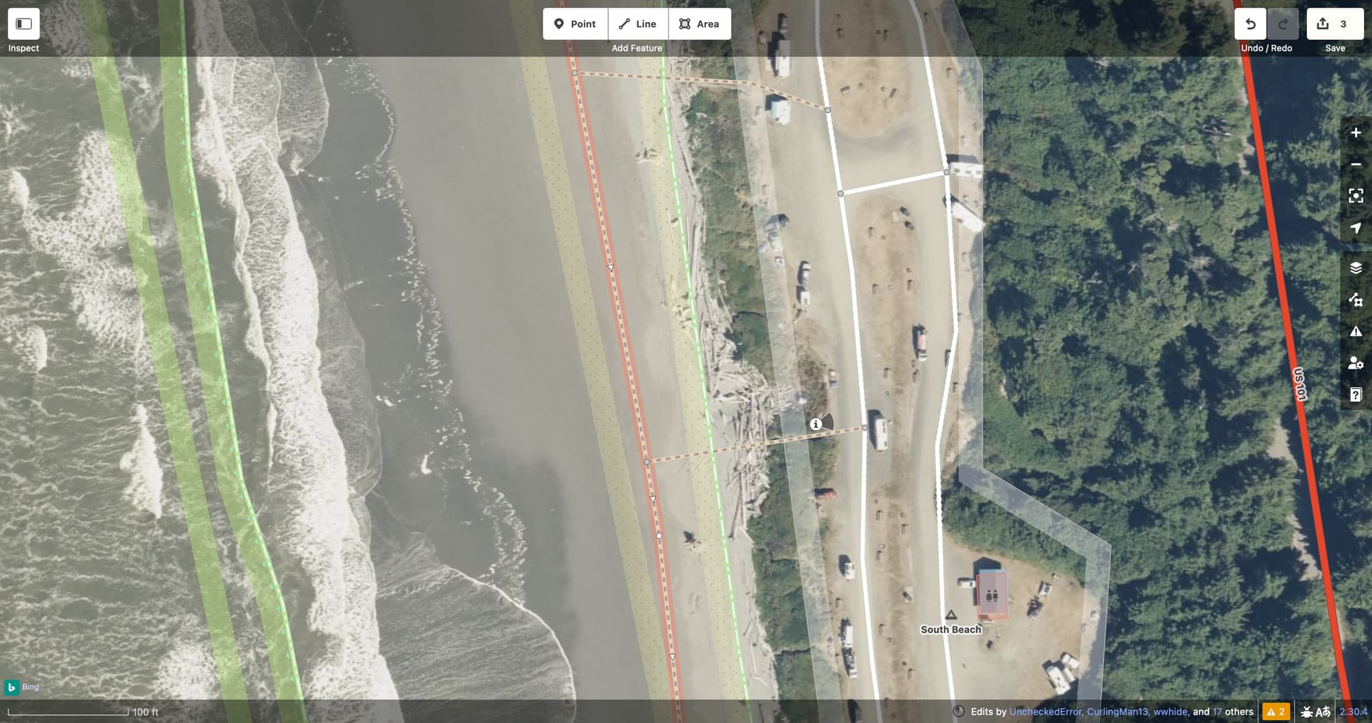
The South Coast Route, mentioned earlier, doesn’t go in a straight line, because the coast doesn’t go in a straight line. The trails have been mapped as paths, but not straight paths – far from it.
This trail is marked, sort of. For example, this trailhead sign tells you to access the beach trail by going down the bluff onto the beach:
From there, I guess you’re expected to know where the beach ends and the ocean begins.
Is it appropriate to map out a linear path, even though physically nothing is present apart from the beach itself? Can we think of it as a “centerline” of sorts, despite the shifting tides? Or is it more appropriate to connect a path to two ends of the beach area and expect routers to calculate an optimal path through the area? (Few if any routers can do that in practice. That’s why we also map footpaths through perfectly well-built pedestrian plazas and such.)
Fortunately, this beach is not as demanding as some of the alpine trails that have come up in these discussions, at least when the tide is out. Still, you’ll want to mind the beach logs:
I am not sure if you are joking or not. Nobody is suggesting, I think, to map a few meters of invisible path as pathless. However, there are a lt of ways in OSM that are not really visible on the ground and yet they are mapped. Opposing moving them to some new tag apart from highway=path in practice means keeping them, as there is strong resistance to having them removed. And pretty much everyone agrees (seems to me) that using highway=path for stuff where you more climb than walk is at least suboptimal, as it then gets rendered in general-use maps leading to all kinds of trouble.
Any pedestrian routing that you can follow in the world, up to but not including climbing routes, is a valid feature to tag as highway=path (if no other competing tag applies) as evidenced by real-world usage.
That includes:
Paths that are hard to follow
Paths that are overgrown
Paths that are not really visible on the ground
Paths that are really really hard to see
Paths that require following other features in nature
Paths that are hard to traverse
Paths that are dangerous
Paths where you have to use your hands
That excludes:
Places where there is absolutely, positively no path at all
I note that:
Is a bad (in my opinion) reason for removing something from highway=path. That is better accomplished by properly tagging other attributes on the path and letting the cartographer decide whether or not it should appear on the map. Our job as mappers is to do proper data entry to describe the feature in front of us, not to second-guess mapmakers or insert our judgement about the danger or suitability of a path.
Please don’t use that argument. There is nothing between countries or counties, either, yet there is tons of borders on the map. There is nothing on a sea but waves yet there are ferry routes, and so on.
What is being drawn on a map in this case is a safe, ordinary, or optimal passage way through an area.
As shown in one of the threads, instead of looking for a way to pass up the mountain in a fog and among the ridges, the map shows where it is safe to do so. Especially if there are cairns or other markers. But even more importantly when there aren’t (grassy area, desert, volatile area, not frequently used, etc.).
You seem to be the perfect candidate to ask - why not apply the same to roads? Two to three additional tags would be more than sufficient to express the differences between different types.
Edit: Aren’t roads just another path, with specific characteristics?
Part of the reason why we are here is because at least some of those cartographers are either crap or very time-poor, and don’t even know that there is a decision to be made.
OSM mappers are also sometimes crap and lazy** and sometimes don’t use other tags.
That is fundamentally different though. By the nature of cars, you cannot have roadless road, as cars leave tracks. You can have pathless paths because while people do leave tracks too, those can be very faint or can be very quickly erased (as everything, this has exceptions, like Ninety Mile Beach, New Zealand - Wikipedia ) (and on some surfaces that people can walk on but cars cannot, like rocks, even people leave no trace).
However, you apply the reasoning that all paths should be distinguished by secondary characteristics. But you do not want to apply the same reasoning to roads. At least to me, an avid car-hater, all roads are kind of the same:-). Yet we have 21 or so primary tags for them. That is what @_MisterY was aluding to, I think.
By statements of both the person that deleted a path (forum post) and the person that remapped the path (in CS comment) there is nothing on the ground where the openstreetmap data derived maps shows Sentiero 30 that meets common criteria of a path. Perhaps even by the criteria of yours, but I am not certain. Expert mountaineers find their way through the area by using a map and judging azimuth, the CS comment says.
In the CAI statement I was wondering about the reference to kompass. I thought it was about a compass, the device? Now I think it is about Kompass, a map producer (from my home town, btw.) They actually show Sentiero 30 on their map there as a marked trail. The geometry though off by a lot.
Perhaps it is time to add one more good reason: Paths that are on a map?
There was a post above about “pistes” in Bolivia. Introduce Pathless? - #60 by Allroads - I found that very interesting and not off-topic, and I like the off-piste, off-track terms.
Perhaps the best translation for German term “weglos” (pathless word by word) off-path then?
I know it is an oxymoron (btw, I already asked what the best term for it is, in the first post) and, therefore, your question sounds like asking to describe a hole. A hole is usually described by describing what is missing, no the hole itself. Which may or may not be the right thing to do.
I would say that, based on the experience on OSM (Weglose 'Wege' im Hochschwab), a path is a way that is clearly visible on the ground, or is known to a (particular?) group of people, is found elsewhere on the maps, or whatever other arbitrary reason one may have. A “pathless path” is a way that does not fall into those categories, yet serves exactly the same purpose. Hence the need for a proper way. In the legend from a paper map, posted by Hungerburg, it would perhaps best be described by Traces.
Truly “Weglose Gelände”, or pathless areas, likely do not need a line.
The lack of visible path is caused by the characteristics of the terrain (rock or hard mountain grass) and the (small) number of people who pass through it, possibly choosing a way that is close by, such as walking across a grass field. However, just adding a “pathless path” across the field shows that there is a route there. And it is not just a relation linking a starting and ending point, because it shows that one should follow a certain trajectory, since going a different way would be way more difficult and dangerous, as described in Alpinist routes marked as footpaths.
It would describe areas and ways such as Weglose 'Wege' im Hochschwab - #16 by _MisterY
And one possible purpose would be to find ways through Weglose 'Wege' im Hochschwab - #13 by _MisterY.
Edit: The purpose is two-fold. 1) To make it clear to people who expect to find a path there, that there is no such thing. 2) To make it clear to people who expect to find dangerous terrain there, that there is a possible way through.
Definitely not off-topic. Shows that the same concept is applicable for cars.
The same goes for motorbikes (Paris-Dakar), where the winning brand is KTM from Austria. Seems like most of the rest of the world is fairly happy following the beaten paths.
This argument can be undermined by the fact that the concept of a unvisible or hardly visible (‘pathless’) path was a consensus in cartography and mountaineering[1] long before OSM existed. I don’t think we need to discuss this anymore.
The only question is when do we start talking about a ‘pathless’ path? When nothing is visible? When there are only small cairns? Only traces? How do the pathless proponents here want to demarcate that? What’s your concept?
Since we don’t need to discuss this, I’m not sure why we’re all here.
If it’s hardly visible, map as a path. If it’s completely open terrain without wayfinding indications at all, don’t.
There seems to be an implied argument that a “path” must have some sort of “trodden on the ground” characteristic. I disagree with this. You could be following periodic painted blazes on bare rock. You could be following a series of piles of rocks. You could be following poles installed in the ground. Whatever. If there’s any, and I mean any physical manifestation, I think it’s perfectly fine to tag it a highway=path.
I strongly disagree with otherwise drawing connecting ways across open ground just to indicate:
We don’t map one mapper’s perception of safe or optimal passage in OSM. We map objective geodata that can be confirmed by the next mapper that comes along.
In the case where:
…that’s a path. It’s marked. With physical indicators. Tag it! Connect the lines from cairn to cairn.
However,
…that’s not a path!
Anyways, I am just one voice here, which doesn’t count for much, but I will certainly vote against any such a “pathless” proposal that attempts to connect a disjoint route over open terrain with ways.
I guess, any of us here debating is just one voice. I just see, that as of today, highway=path is used for what you would vote against if put up as a proposal.
I think this comes from path being greedy, in IT-terms, e.g. when speaking of regular expressions. It takes it all.
I see four paths in picture below, true to the ground trodden paths (I guess by the sheep):
I mapped the spring, and no paths. But that is just me. And thankfully all of openstreetmap contributors that came by there.
Recently, a mapper whom I trust updated a well-known route that has been reorganised. He did not map the glacier traverse. There was one before. At first I thought, funny, how to get to the summit then? Reconsidering, I found that a wise choice, even though mapping that would be fine under the criteria you posted
because, the far side is some such feature.
PS: The Wikipedia article quoted by @Road_Runner is so wrong in so many accounts, I feel berated. Who marks the hiking paths in Switzerland? What colour do the hard or the easy ones carry, in Switzerland, in Austria, in the Alps? These are all informal but come with cables? Come on! You may need ice axes, but sometimes you may even need Crampons, oh my Gosh! Who wrote that?
So it sounds like you would consider hiking routes following the shore[1] to be paths even where there is no trodden path visible on the ground and no visible markers to follow? I would use the word “trail” for such routes, but would reserve “path” only for sections with a visible, trodden path on the ground.
“pathless path” comes across to me as nonsensical and self-contradictory. In the context of hiking, I would say that a “pathless route” is a well known, general[2] route for hiking over pathless terrain. I’d probably be more likely to use the terms “off-trail route” or “cross-country route” in common speech.
like the North and South Coast Routes mentioned earlier. ↩︎
i.e. not all hikers follow the exact same line, but instead a general route with some variation. ↩︎
So these routes truly have no manifestation on the ground? No markers or signs or anything? In that case, what, exactly, are we mapping? What even makes it a “route” at that point versus a suggestion that it would be fun to walk along the beach?