
Above is an example where there is “manifestation on the ground”, but I wouldn’t say there is a “path” per se, so it might be considered “pathless”
1 Like
If you want to walk along the beach from here to there, you know whether you can get around the front of that headland or not, how to get across that river, how far it is, how long it’s going to take you, & whereabouts you are in relation to toilets etc
highway=path
surface=bare_rock
trail_visibility=good (depending on blaze/marker frequency)
Seems fine to me. I don’t see why we’re fixated on dirt ruts as the thing that counts.
1 Like
A number of videos of the Olympic North Coast and South Coast Routes can be found on YouTube to see what the conditions are like. As far as I can tell there are no markers along the beach and rocky shore sections. One of the videos I watched explains that the overland trails between shoreline sections are marked with signs like this and can be a bit hard to find sometimes:

As for what even makes it a route, I suppose we could ask the US National Park Service since they publish a fair amount of information about each one. If pages like that were published by www.wildjimshikingworld.net, I’d be inclined to say these are just some hiking routes old wild Jim recommends, and they are not qualified for inclusion in OSM. But when the documentation is coming from the land manager it feels a bit different.
2 Likes
I like @SomeoneElse’s rule to balance out one’s forum verbiage with a commensurate amount of mapping. The last time I followed this rule…
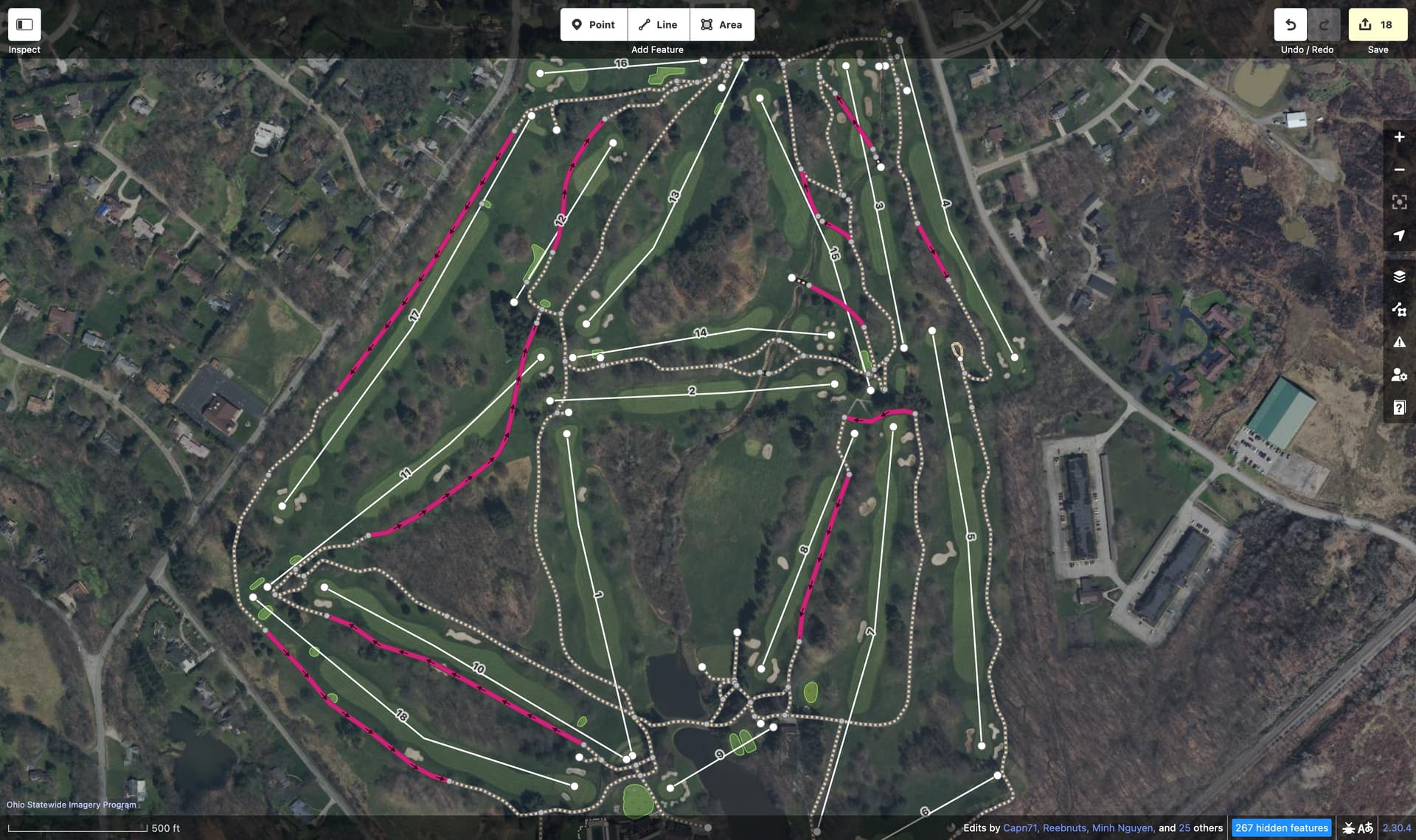
…I left out vast sections of the route that every golf cart will take from Hole 1 to Hole 18, because the highway=path just ends abruptly, without so much as a desire line to indicate where the golf carts actually go.
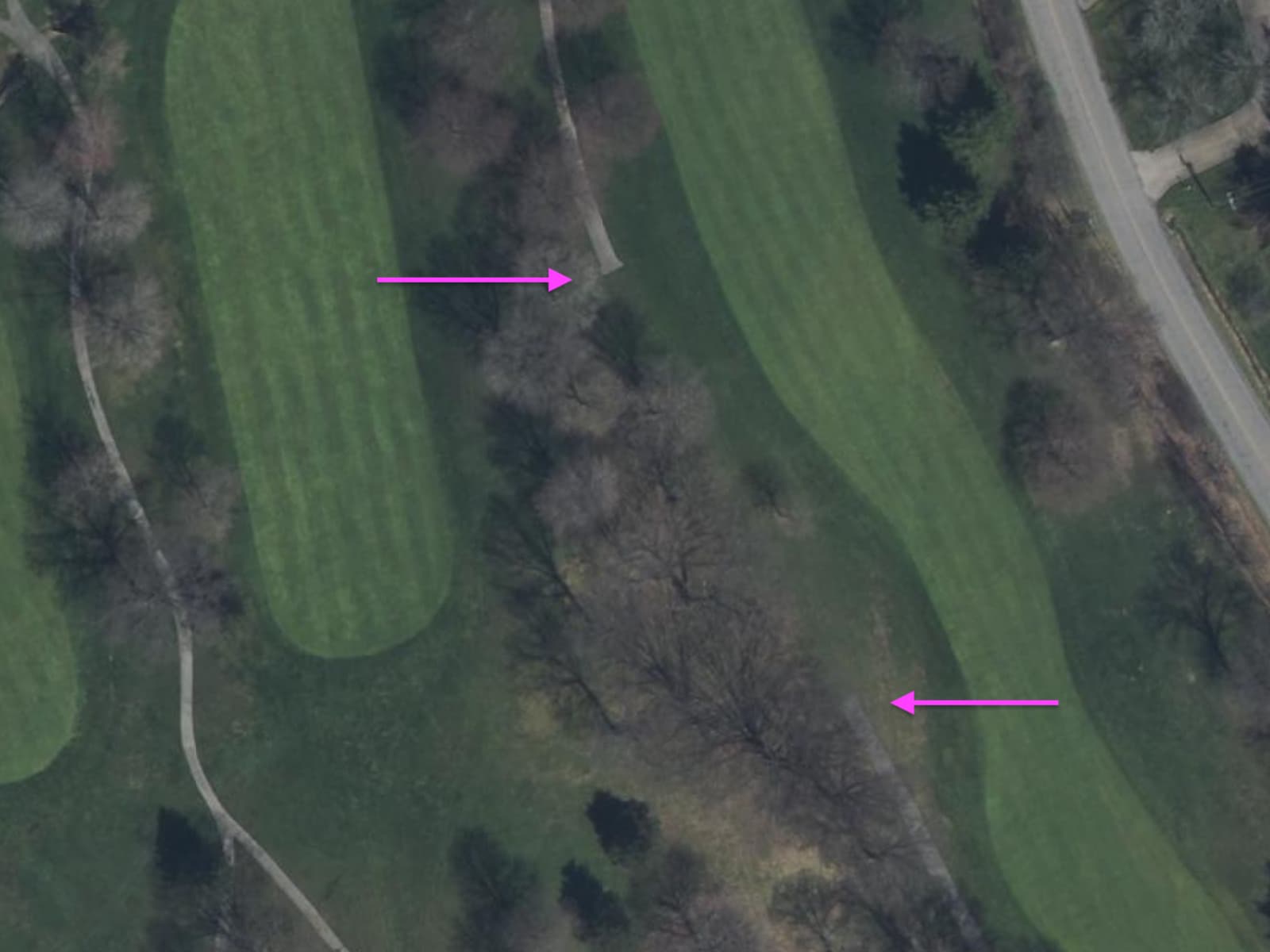
For all I know, this country club might have a tradition of sending every cart on a zigzag across the fairway, like the last time I went canoeing.
To aid in golf cart routing – which is actually a thing – perhaps I should fill in the gaps. Here’s my best guess as to where the golf carts go based on the hole numbers (minus the zigzagging):
iD is so proud of me for having resolved so many disconnected path warnings. But I’ll need us to reach a consensus on a tag before I save this changeset with the placeholder highway=motorways instead.
2 Likes
Yes, we are confident that the rendering situation will be any better, if we change highway=path to highway=some_new_value, for invisible pathes. The invisible pathes will no more be rendered. It is a generally better situation.
2 Likes
Since “pathless path” seems to attract people who are irritated by the name and don’t generally check the referred thread for “documenting problems with path”, I’ve adjusted the title a bit and have also added some references mentioned throughout the thread to the first post.
2 Likes
I don’t think that’s the case. In my country (UK, and specifically England) it’s generally not permitted to go wondering around the countryside unless you’re following a route that is a legal right of way (typically a Public Footpath or Public Bridleway). Often these are poorly marked on the ground and depending on the terrain and level of usage, there may or may not be much evidence of use on the ground. Nevertheless the legal right of way exists, and for countryside walking in the UK it’s necessary that they’re shown on maps and available for routers.
Hence it is useful that such routes are mapped as footways/paths/bridleways, with additional tags to record their surface and visibility. If maps were to stop showing them and routers stopped routing over them, it would seriously degrade the quality of the map in England and Wales. We already have sac_scale=* surface=* smoothness=* and trail_visibilty=* to capture the various aspects that might matter to users. What advantage does something like highway=pathless have over proper use of these tags?
If people are put in danger by following a marked alpine path in the mountains without properly assessing the conditions, then I think that’s on them (or potentially on the map/router provider for not making use of some of the other tags in our data). If you’re on a mountain you should expect paths to not necessarily be marked/visible, and the paths shown on maps to be the better routes to take given the situation on the ground. If it’s possible to get a a summit, then it’s arguably better to show the least worst route then nothing at all. On the other hand, a perfectly usable and safe public right of way route across open fields in the UK is not shown on a map or available to a router, then that just makes our map look stupid.
3 Likes
My understanding kind of was that you do not really have paths in UK, only footways/bridleways/cycleways? Are there really paths (as in access unrestricted) with trail_visibility=no/bad/horrible that are not scrambles at the same time?
And then again, nothing prevents routers/renderers catering to UK to show pathless/off_trail with appropriate access tags filled in.
And then again, nobody would force UK community to use pathless if they prefer alternative solutions.
But this whole long discussion came from the fact that people did get lost, stranded or hurt by following mapped “paths” that are in fact dangerous, be it by the omission of their own, their routing applications, or OSM mappers.
My worst mishaps while hiking invariably followed the same scenario: I took a wrong turn, following a path that looked fine in the beginning, then got gradually worse (steep/overgrown/invisible) to the point when it was almost impassable. Neither going forward towards a nearby-but-unreachable mapped road, nor backtracking a few miles through a difficult terrain were attractive options.
The above common scenario is not necessarily an issue with the map I was using (just my own carelessness), but there were also mapped trails where the last human being walked a decade ago, or were recorded on GPS tracks made by some crazy adventurers back then. The point of this discussion is that we’d just like to clearly indicate those that we know are dangerous or invisible, and have a right tool to do so in the future.
5 Likes
Short answer: the same as primary vs secondary road. (And tertiary, and service…)
Long answer: fixing part of the issues from Documenting the problems with `highway=path`
For the rest, I completely agree. But many others don’t. My paths get deleted because they are not paths. Not even mappers tend to look at the secondary tags too much.
Many maps will also ignore the secondary tags on paths and show all paths to be the same. Even though there are several categories.
I think an additional problem is that the sac_scale deviated from the SAC scale, adding to the confusion.
Road highway classifications exist for the purpose of differentiating the relative importance/connectivity value of roads in the highway network. It is completely irrelevant to the argument here. Nobody is arguing to tag roads where no trace of road exists.
OK. Are there traces on water from ferries?
What is the difference, then, from making the same distinction for walking paths?
Edit: the $1M question is - is it OK to use the same tag for all these examples: Documenting the problems with `highway=path` - #10 by _MisterY
For the record, I’m perfectly fine with the beach walk between this marker and the next one being tagged highway=path. Path does not require a strip of compacted dirt. Why can’t a path be on sand? When you are in the woods, the path is the cleared bit between trees and brush. Along the beach, the path is between brush and the ocean. I don’t see an important distinction here, I would 100% tag a path through here for a marked trail. The trail markings are physical evidence of the path. It’s a place made/curated/trodden by people to walk from point A to point B.
You aren’t making this distinction. You aren’t saying “these paths are more important than those paths”. You are saying “there is no path here but I still want to tag something”. That’s why the comparison to roads is not relevant.
That is because you have a certain understanding of “path” that does not match that of others. And that is what we are trying to clarify here.
If you look at Documenting the problems with `highway=path` - #10 by _MisterY, you will see what path means for different people. And gets tagged appropriately in OSM. The others may expect to find their version of “path” when they get there and that poses a real problem.
I find that the differences between these types of paths are way bigger than any one can find between a primary and a service road. Yet, that distinction is so important that it deserves a different tag, whereas these are all fine to be distinguished with 10 different secondary tags. Why not use subtag “importance=primary” on a road?
- People get lost because they can’t follow the terrain for whatever reason (thread on alpinist paths…)
- Paths get deleted because “there’s nothing there”, even though they exist on historic maps and there is an occasional cairn. For some, that is enough, for others not.
3 Likes
OSM is a rich tapestry of people that have different views on how to tag what’s in the map, and that’s OK. Consider these threads an opportunity to collect data on the variety of opinions that exist in the world on how to map, rather than an opportunity to try to sway people to your point of view.
I assure you that there are absolutely paths tagged in the map in the way that I describe, I’m expressing my view and experience, and I will oppose efforts to undo that. If my position is in the extreme minority, then that will be discovered.
2 Likes
And there are already existing established tags that you can use to do that, without intruding a new highway=* value.
2 Likes
Funny how nobody ever answers a direct question in these threads.
2 Likes
ok, so why do such paths get deleted, then?