I recently hiked a trail that was marked on OSM as a footpath.
It turned out not to be that, but an alpinist route requiring special skills and equipment.
After literally surviving it, I went back home and I removed the track from OSM.
I got a message from the author, stating that they restored it as “being an expert alpinist track of great value” and telling me not to delete anything “that is not my competence”.
I replied that I have surveyed the path myself, so I am competent enough to rate and make a choice on a map that is common, and not certainly private.
I did not remove the track again, I hope he will, but I really need a confrontation with you guys. Thank you very much.
And the new version, now tagged with sac_scale=demanding_alpine_hiking (i.e. indicating an “alpinist route requiring special skills and equipment”) and trail_visibility=no: Way History: 1307520308 | OpenStreetMap
My fear is that other maps might draw it as a “path” of any kind, while it is not.
Not counting its visibility - it’s just a vast sequence of massive granite blocks - which might be OK, if you follow the OSM trail as we did - the issue comes when you have to rappel.
That is not something that you do on a hiking path. You must know that ahead, and come prepared.
Can that be somehow noted on a map? If not, isn’t it reasonable to ask for that trail to be removed? There are plenty of websites where you can find and download GPX tracks for several mountain adventures, alongside with a description of them and the equipment and skills needed.
Putting such a track on a public map as a “non visible path”, though, is something different and does not provide any extra precious, if not vital, informations.
When you say “marked on OSM” what OSM map were you using? Some general purpose map, or one designed to show some idea of the difficulty involved in mountainous areas? Sometimes “general purpose” maps ignore specialist tags. Recently, there was this discussion about a potential way forward based on tagging, but the other side of the coin is “general purpose maps should not show paths that general purpose users can’t access”, and to resolve that we’d need to know which map it was.
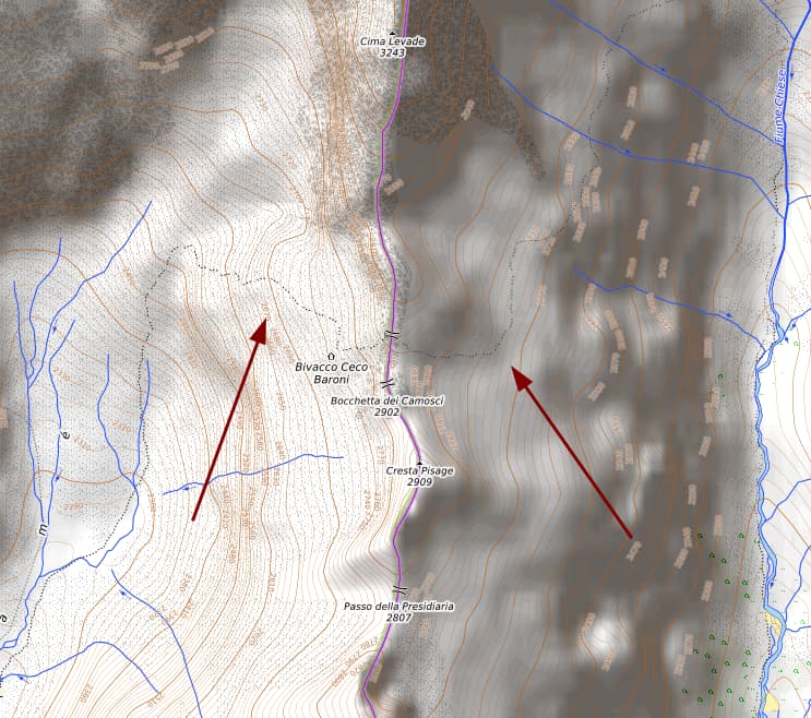
On the left, there is a moderately difficult mountain hike.
On the right, the expert alpinist, unmarked track requiring ropes and rappels which I deleted.
They appear very similar on the map, and that one is indeed a very specific hiking map.
It is a sequence of rocks with no trail whatsoever, either marked or unmarked. The only reference we had was the OSM cartography track. Until we found ourselves stuck on a steep waterfall the track was passing onto and that was impassable without a rope.
Small note: As far as i know opentopomap is currently not maintained and does not render new tiles (only provides old cached tiles). See OpenTopoMap Serverwartung (german, but you can use the translate button)
With regard to the path mentioned: I think the tagging with trail_visibility=no and ‘expert’-sac_scale is fine, but we should make sure that such tagging is regarded in more map styles. It is indeed somewhat unfortunate that a route that is already tagged as not visible is rendered on the standard map style.
In which case you should lodge an issue with the very specific hiking map, rather than deleting real-world data just because one or two maps render it wrongly.
So, the general consent here is that the route is fine as it is at the moment?
If that is the case, as it seems, I’d accept it, but I would nevertheless be puzzled. What is the sense of mapping something that is totally arbitrary, as does not exist on the real world whatsoever?
@Superfebs Just a general hiking tip: if you are hiking in the mountains, always study and carry a paper map. OpenStreetMap is usually quite correct in that region, due to the extensive involvement of the Club Alpino Italiano (CAI), but for mountain hiking preparedness is key, even if just as a fallback option. Ideally you have both digital and paper maps available.
That path was marked as sac_scale=alpine_hiking, currently it is demanding_alpine_hiking, which seems to suit it better. It looks like it is tagged correctly at the moment.
Generally speaking all sac_scale with alpine in them are only suitable for experienced mountain hikers. Maps geared towards hiking should clearly show that this is the case. If they don’t, do file a bug.
You could ask the CAI if that trail is indeed marked (even minimally), but their changeset indicates that it is marked, although badly:
Il sentiero è segnato da vecchi segnavia sbiaditi.
If a rappel is in fact the only option to continue, marking it as a path even with T5/T6 SAC scale might indeed be questionable also because using it in the other direction would then possibly require more than grade II climbing. But I lack the local knowledge to assess that, there might be other option to avoid a rappel. Maybe @CAI_Salò (not sure if the tag works, the username has a space instead of an underscore…) who created this path has any input?
The newly created path to replace the one you deleted deviates quite a lot. So much to the arbitrary. There is absolutely no Strava heat in this area. Strava heat stops right at the saddle.
The relation the “path” is part of (as single member) is not of type “hiking”, it is of type “route”. Curiously the “path” is also of type=route. Is that a way to tell, that this path is not a path?
Shouldn’t Superfebs have seen them? Perhaps they are completely faded, not just in the process of fading?
I trust Superfebs. In my opinion, the path should be marked abandoned:path and when the CAI Salò refreshed the trail blazes it can be put back.
The faded trails signs are there only in the first 200/300 meters. Then there isn’t any. We were two people and precisely walked the route, plus making several detours to search for any trail way marks, in vain, until we got to the non-passable terrain.
CAI Salò told me in practice to mind my own business because that is not my competence, except the map is open and it is competence of everybody.
This is their message.
“Ciao, è stato ripristinata la traccia Sentiero 30. Si tratta di traccia alpinistica di grande valore per alpinisti esperti. Sei pregato di non cancellare nulla che non sia di tua stretta competenza.”
which Google translates with
“Hi, the Sentiero 30 track has been restored. This is a mountaineering track of great value for expert mountaineers. Please do not delete anything that is not within your area of responsibility.”
Leaving aside the highway value, do the other OSM tags on this way seem correct to you? You can click through from e.g. sac_scale to the wiki. Are these wrong? If so, what would be better?
Note that “what tags are in OSM data” is different to “what a particular map shows”. Sometimes data consumers such as maps misunderstand the data in OSM and misrepresent it - problems of that sort need to be sent to those maps if the OSM data is correct. There is an additional problem here because one of those maps as noted above appears to be unmaintained.
Strava is a requirement for alpine mountain hiking now? At most you can use that to deduce that Strava users seem to stick to the less demanding trails.
Or you could defer to the local experts (CAI) first. You know, ask them, involve them.
That is a fairly polite reply for someone blithely deleting someone else’s work without seeking a dialogue. Mappers do tend to get annoyed at that.
By the way, you’d have to ask someone with native Italian proficiency, but stretta competenze is more like core competency, not area of responsibility.
Also, I frankly didn’t even know I could discuss with the author, this is certainly good to know. But please bear in mind that every single edit I do on this map is for the sake of making a better map for everyone, as it should be.
Also I’m afraid you don’t know who the “local experts” are. I’ve been a member of the CAI for so long. Being a member of the CAI doesn’t mean you’re more right than anyone that just walked that rocks recently.