Along with many other folks, I’ve been exploring @amapanda_ᚐᚋᚐᚅᚇᚐ 's OSM River Basins map (original announcement thread), and connecting missing links in rivers and streams. In order to make a fully connected waterway network, it seems to be a fairly widespread practice to map linear waterway features through lakes. When looking at smaller lakes with a waterway=stream or waterway=river through the middle, this makes sense to me. The water flows somewhere and the lines help show this. It does seem a little odd to be tagging these lines as streams or rivers when they are in the middle of lakes. Perhaps not a problem though. It seems that mappers often leave these lines without a name tag. This also makes sense to me since a lake will most often have a different name than a river that flows into or out of it.
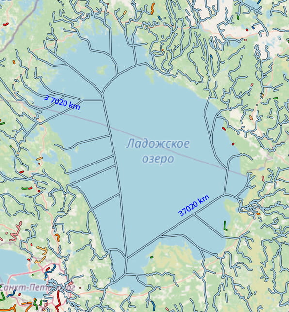
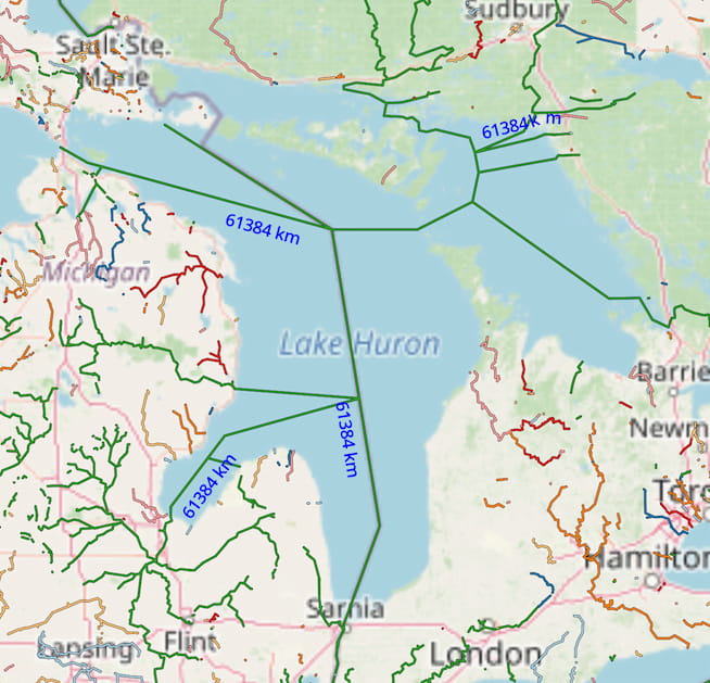
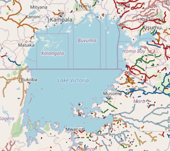
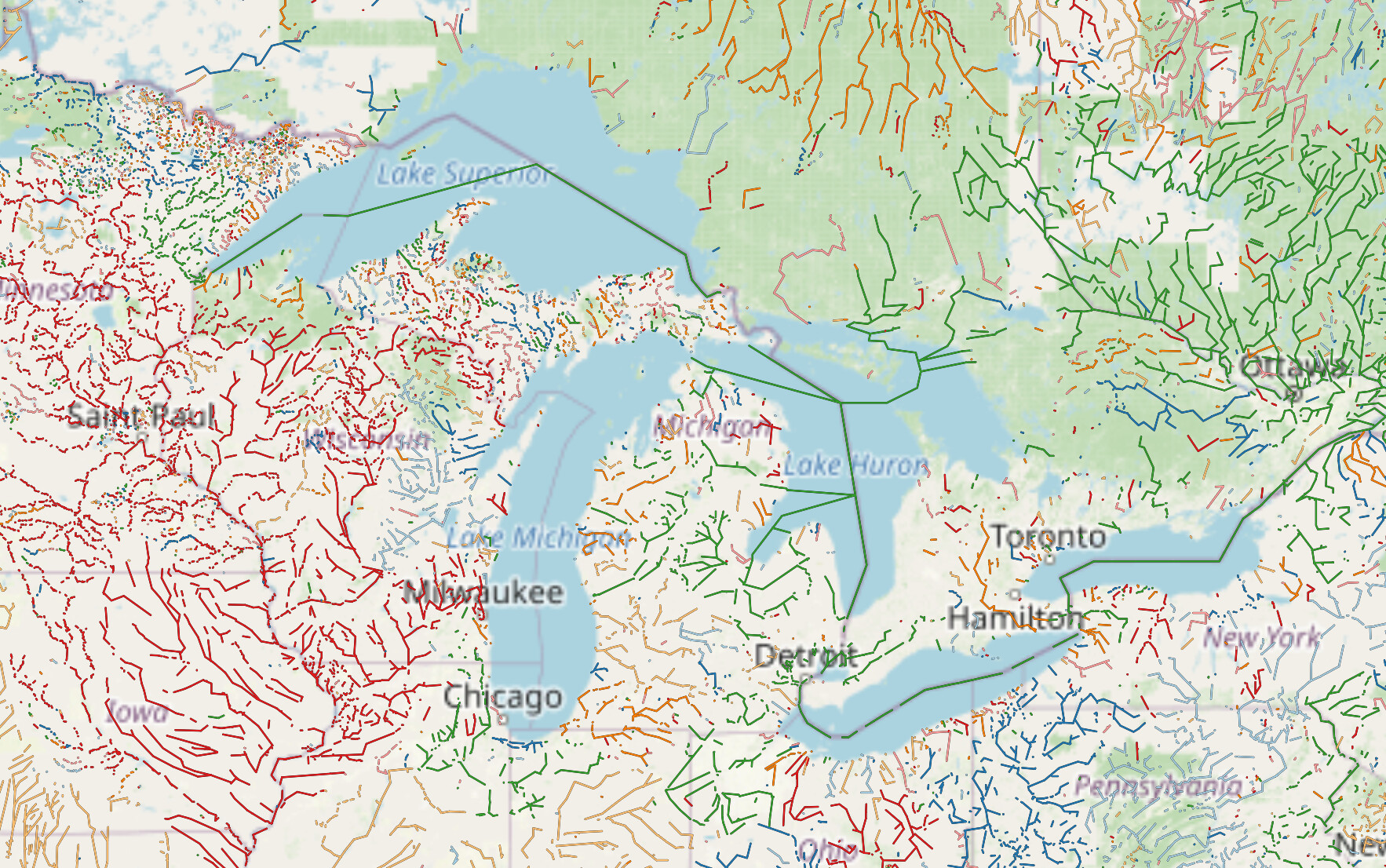
Once I started to see “rivers” mapped through very large lakes, though, this started to feel perhaps not quite right. Here are.a couple of examples:
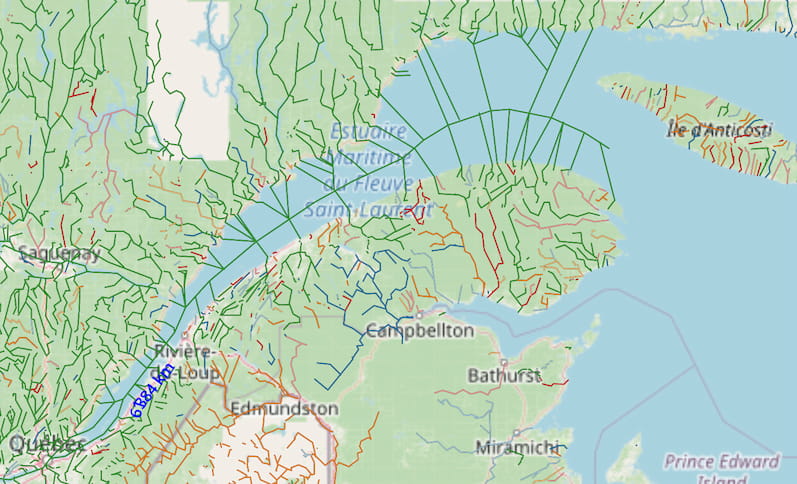
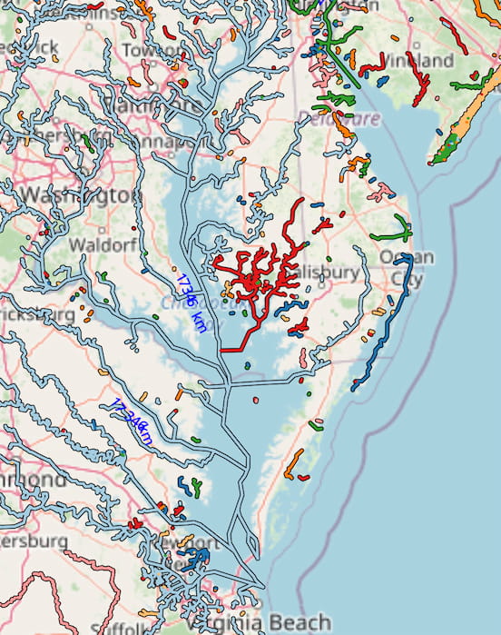
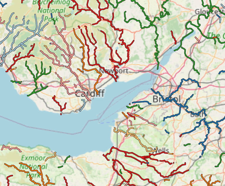
I also noticed the same sort of mapping with some large estuaries. These are outside the coastline so it feels even a bit weirder to be mapping “rivers” through them. Some examples:
What do you think? Should waterways be mapped through very large lakes or not? How about estuaries or elongated gulfs or bays that are outside the coastline? If waterway lines should be mapped through these water bodies, what value should be used? Is the common practice of using waterway=river acceptable or should a new waterway value (or several) be developed?
I personally would connect 2 lines of the same river if it goes through a sea. Same if a road goes over a place.
I would not connect rivers like a street network like in some examples above.
First of all, it is necessary to give an answer - why this, the connection of riverbeds - should be done. For me the answer is to be able to lay routes on linear water networks.
Based on the answer in each case, you can choose the appropriate approach to mapping.
Thanks for raising this issue @ezekielf – I followed the same train of thoughts as you and I was glad someone else started it first.
I have mapped a lot of waterways and I’m among the ones who consistently “map linear waterway features through lakes” (usually omitting name and even “hiding” it using layer=-1). However, where I live those lakes are almost all dammed reservoirs, so it comes pretty natural.
I agree with andygol and R0bst3r that mapping virtual waterway through large water bodies constitutes a best practice, to facilitate routing through radial water networks and simplify the model for water-routing and QA applications (such as OSM River Basins). I just spotted a large unconnected basin off the south shore of Lake Balaton, but then I realized that someone has already created a virtual waterway there where those streams can connect.
I also agree that such virtual waterways should be simple linear ways roughly following the centerline of the waterbody. They should branch only if there are major gulfs or bays that collect a significant number of tributaries.
Can think of the conceptual tag of river/stream=link similar to mapping cycleway and footway=link sections to express it’s for routing across areas…
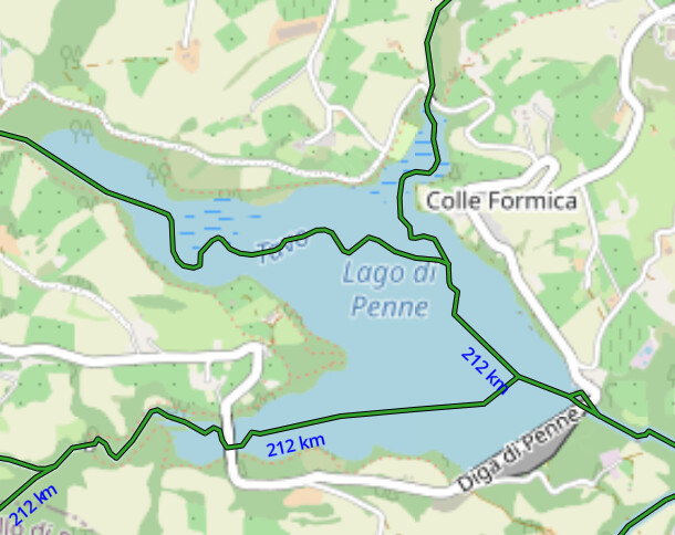
We have several reservoirs that fill up in late autumn/winter/melt season where the actual original path of the streams/rivers are ‘revealed’ at end of summer, Lago di Penne between high in spring and low end of summer, draining exclusively for irrigation is some summers 21 meters or more, a gauge on the sloped dam wall showing the state of affairs.
Wouldn’t waterway = lake/reservoir/bay/estuary be a natural choice? Actually, it’s probably a good thing that those won’t render under most of the current OSM stack.
(Btw, I wish there was waterway=oxbow to accompany water=oxbow… most oxbow lakes are actually long linear features. I know, “any tags you like”, but those are the ones I’d want to be rendered).
The wiki for waterway=fairway might be worth a look
quote: Use waterway=fairway for a linear representation of a navigable route in a body of water such as a lake or sea, in cases where other values such as waterway=river… are not appropriate. Do not use instead of waterway=river…etc.
Seamark:type=fairway is also a possible addition. although they only have a few thousand uses between them.
without a consensus, as far as I understand. Again there are a couple of topics dealing with the same problem in the german community. I am looking forward to the outcome here.
What I’m hearing so far is that folks do consider waterway lines through lakes to be a good practice, but perhaps tagging them differently from rivers or streams would be an improvement. The idea of virtual or link waterways makes sense to me. I also noticed waterway=fairway, but it seems to generally be indicated by man made markers of some kind. So a virtual line through a lake where there are no markers may not qualify.
Also it is a good point that reservoirs can be considered not an interruption of a river. A waterway=river line going through a reservoir make perfect sense because the reservoir would not exist if the river wasn’t dammed, and if/when the reservoir is drained the river will still be there. So I think reservoirs can be left out of the discussion about whether any different tagging would be good for other types of large water bodies.
It also seems like virtual waterway lines outside the natural=coastline in estuaries, gulfs, and bays are more questionable than those in large lakes.
At least some mapping of waterways outside natural=coastline makes sense.
Coastline in OSM follows mean high water springs, and for regions with significant tides, there are often substantial areas exposed at lower tides. It makes sense to map established channels for streams in those areas.
The only reason to map these “virtual” waterways is to make the rivers join up topologically, but it can be done without all this hassle. (In the simplest case, someone pointed out that you can just consider the lake as a “roundabout”.)
Adding waterways through larger lakes is just tagging for the renderer, and we shouldn’t be requiring it. In some situations it also means river names unexpectedly appear in the middle of lakes.
That said, I think there are some cases where mapping waterways within larger bodies of water is still useful:
Smaller lakes (and of course riverbanks), where it simply makes more sense to keep the linear waterway mapped.
Tidal/intermittent areas of water, where the route of the stream is sometimes visible when the water level is lower.
I support @Russ comment above.
l also support the two bulleted exceptions to the rule at the end of the post.
Mapping rivers over lakes does not seem to conform well with the “what’s on the ground (water)” rule. To draw virtual rivers over lakes can only have one purpose: Mapping for render/router. Routing should use line-of-sight routing across open areas and make use of seamarks data to improve routing.
If the river continues on the other side of a large lake I would expect there either to be identical tags or a relation.
The river-basin map should not rely on connected river-centerlines. The lake body should be included using inflow-outflow to calculate the river basin coverage.
If we map a stream/river relation, does leaving out the lake sections not cause validators to act up with ‘you’ve got a gap’. If only consumers would be able to interpret the omnidirectional areas as part of the route we’d be done.
At any rate, as it is now got a reservoir that before it became one had 3 torrents converging in it and now the map show depending on the zoom all these names in the reservoir on top of the reservoir name. Fortunately the streams themselves don’t render in the standard issue else it would look a little perverted. It certainly would break in the present config Amanda’s river basin project showing the total tributary distances of watersheds like the sample below. Most of the 212km feeding the Tavo would be gone. Not ready for that yet.
note that “should not be done for Great Lakes” does not mean that it should not be done and should not be required in general and “document that it isn’t required” should not imply this
I don’t think we necessarily need a solid rule here - we just need to make sure that people don’t rely on (or massively over-map) these “virtual waterways”. But a good rule of thumb might be:
If the same named river flows in and out of a lake, then it should continue through the lake (and other inflows should join it). Otherwise the inflows should terminate at the edge of the lake, or at the lowest water line if the level is variable.