Hello,
In Lake Edward, between DR Congo and Uganda, I’ve found many ways connecting large and small rivers in the middle of the lake.
In my dumb opinion, it would make sense just in case a river’s relation exist and the mapper wouldn’t want left gaps in the relations.
Is there any guidelines about the topic?
Thank you
Alessandro
“All rivers, canals and streams should normally be represented as a linear ways. Those ways used should point in the direction of water flow and connect with other linked waterway features to create a routable network.”
I see two streams that are connected with tagless lines: this one and this one.
There are some very long lines JOSM complaines about. For example this one, 30 km long. As I have understood in the past these long lines are preferably split up by adding some nodes here and there in 1 - 2 km segments to make the conversion [Round Globe] → [Flat Map] better or easyer.
The “main channel” is tagged waterway=river. I myself would tag it as waterway=lake because Lake Edward is obviously not a river.
But others might think different about these things
Not to say that shouldn’t be followed, but it seems weird to treat streams on the opposite sides of say a 50 mile lake as if they are somehow connected. There’s also no way to verify where exactly the way for the stream/streams should be mapped. For instance there’s been multiple instances in my local area where someone mapped a waterway through a water body as a straight line, and then when the water body dried up it turned out either the waterway didn’t exist or in reality took a completely different route then how the person had mapped it.
Again, that’s not to say the practice shouldn’t be followed, but maybe just make sure it’s not being followed for it’s own sake and that the route your creating at least somewhat matches the real world. Otherwise, I’d just map them as disconnected waterways that end at the shore line of the waterbody.
Lol. I didn’t say it at the time but I don’t think there’s any apps that do routing for waterways anyway. At last not out of the box. I guess OsmAnd+ has a plugin for nautical, but that’s all I’ve ever seen. So the whole idea of mapping a waterway to create a routable network is sort of moot point to begin with. Although there’s probably some very short canals in Europe safely use OpenStreetMap to route a boat through if you really wanted to but it’s definitely an extremely small, if not exiting, niche.
My question aimed to know if any convention exist. If doesn’t exist, should be nice to discuss to set some rules.
Drawing these ways for routing purpose sound strange to me. We don’t do on highways’ areas, why we should do on waterways?
As I said, in my opinion, this could be done if a river keep the same name before and after a lake, and this river has a relation (so the relation wouldn’t have gaps).
I’d take “routing” as a logical term for pathfinding, not for actual getting directions for a boat tour.
Drawing waterway=* inside of water=*-areas is the same as drawing highway=service inside a amenity=parking-area.
If you look at the water bodies around Stary Staw (Stary Stow?) it looks like they don’t even connect to each other from side of the water bodies to the other or for that matter even on the land. Plus it’s not a router anyway. But OK.
Sure, but the wording of the Wiki article for waterways make it sounds like it’s a practice because people currently do it. " Those ways used should point in the direction of water flow and connect with other linked waterway features to create a routable network. “To create a routable network” makes it sound like it’s a thing that’s currently possible. Otherwise, what’s the point since we can create all kind of practices for things that software might do in the future. If your going to tell people they should do something because of X reason then that X reason should at least exist when your telling them to do it and not be based on future plans or theoretical features of nonexciting software .
As you already mentioned, OsmAnd will give you routes over waterways. A bit of testing shows it will happily route between marinas on the English canal network so a routable network does already exist for OSM waterways data. I don’t know if the routes it proposes are actually navigable with any particular vessel but it at least shows that this is not some nebulous potential future capability but something that actually exists in current software.
Personally, I’d consider one mobile doing it via a plug rather nebulous and more about future potential. Especially if you tested on English canals, which aren’t what this discussion has to do with. Sure though, routing through waterways can done now via OsmAnd. But is that single use case, which probably doesn’t create actually navigable routes anyway, enough to warrant someone following a certain “practice” when mapping streams that go through lakes? Probably not. Especially since no one can seriously argue that the streams even go through the lakes in the first place. Let alone along the route that the person will map them as following. So, whatever. I stand by what I said. Rivers that flow through lakes aren’t English canals and it makes sense to have different “standards” depending on what exactly is being mapped.
It seems someone would like to add all that “routing information” on lakes.
BUT … have you thought the consequences?
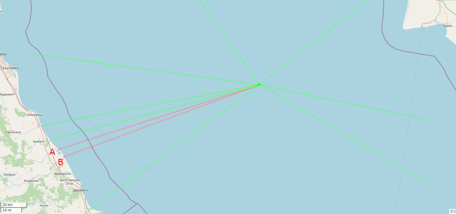
on water bodies like Caspian Sea and Lake Victoria, we should draw thousand ways to join all the waterways
the result, besides the mess on lines (but this is not relevant for this point) would be if one would navigate between two rivers, software would send you in the center point and after to the line joining the second river: for large water bodies like Caspian Sea would mean hundreds kilometers more of navigation. Have you ever considered this SMALL drawback?
On highway routing we avoid to draw fake highways on large squares. Smart software could navigate on areas; why the same smart routing software couldn’t do the same for water bodies?
actually on large squares we typically add highways, particularly if it is drivable (but then there are also typically defined “roads” on large squares where you can drive on, so it is not comparable). Squares apart, we always connect highways on junctions and do not stop at the crossing of the connecting road with the border of the carriageway of the other.
Technically I believe there aren’t rivers inside of lakes, rivers enter and leave a lake, but do not remain to be rivers inside the lake (at least this is common, not sure about strong flows inside of lakes). So far I always thought this representation was kind of a compromise to assist people interested in the network aspect of waterways who can’t be bothered to take polygons into consideration, maybe not “clean”, but acceptable and apparently creates more benefit than problems. If you did more sofisticated evaluation e.g. about the kind of water body, you could exclude those parts of watercourses which are inside of standing water bodies.
People adds these highways due to the current routing limitations; highways routing is massively used.
Navigation imply many different aspects: doing with a kayak or with a vessel; we don’t know the bathimetry; most of the navigation limits are not marked (dangerous areas, etc.).
But seeing the image I posted should be enough to understand that trying to draw routable water network is unfeasable. It would be like to have squares as big as Italy: if such a huge square exist, would you ever draw routable highway lines?
This map doesn’t seem to support your statement. Rivers and streams flowing into lakes are correctly associated as part of the same watershed as lake outlet even if no connections exist in OSM.