[RFC] Feature Proposal - Tag:natural=wadi

I’d like to propose the use of natural=wadi to map the area of the broad, flat channel of an ephemeral stream with distinct banks.

This proposal is the result of an extensive discussion about mapping wadis (regionaly known as dry washes or arroyos) in the OSM Community Forum.

This proposal suggests that the area between the banks of a wadi should be mapped as natural=wadi in order to consolidate several ad hoc and inaccurate tagging schemes for these features.

This proposal does not suggest any changes to the mapping of linear water courses through wadis. These should continue to be mapped as waterway=* + intermittent=* as appropriate following established practice.

The proposal is documented on the wiki at Proposal:Natural=wadi - OpenStreetMap Wiki.

Comments on the proposal are welcome here and on the Discussion page in the wiki. Commenters are kindly requested to read the previous OSM Community Forum discussion as background on the topic.

4 Likes

Looks like a decent proposal, however i am not sure what “ephemeral” means.

Does this proposal include artificial wadies?

For example:
https://www.openstreetmap.org/way/1077439919
https://www.openstreetmap.org/way/1242222560

The proposal is for natural features, hence the use of the natural=* key.

If someone were to construct an artificial wadi, I suppose it could be disused:waterway=canal since it would necessarily be dry. Or if the feature is purely decorative and not functional, an appropriate value of surface=* would suffice.

The Dutch use of the word “wadi” here is a bit of a “false friend” - see https://community.openstreetmap.org/t/iemand-enig-idee-hoe-je-wadi-s-mapt-in-osm/109798

2 Likes

Ah. I see that there are two senses of the word in Dutch.

This would be the dry stream bed, rather than the infiltration basin.

Is it resurrecting of waterway=wadi under a different tag name?

No it isn’t. See:

1 Like

The word ephemeral means “lasting only a short time”, so an ephemeral stream is one that lasts only a short time (usually after a period of rainfall), and is otherwise always dry. On the other hand, an intermittent stream has consistently flowing water for much longer periods of time between its seasonal dry periods.

1 Like

Your quotes imply intermittent==seasonal.

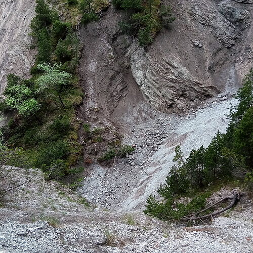
Here photo of a what might get filed under wadi in the area of my local knowledge:

There actually is water there most of the year, cant be seen on the photo, cant be seen on the ground, but can be heard on the ground. It is a stream on layer -1 so to say, under the gravel most of the time.

As much as I understand the desire to create something that can be used to create US topo maps look-a-likes, I am completely at a loss on how to draw the boundaries.

I don’t think the picture above meets the definition of a wadi as we have it in the proposal. The brief definition of wadi from the proposal is “The broad, flat channel of an ephemeral stream with distinct banks” and the more detailed definition is:

A wadi, also known regionally in the U.S. as a dry wash or arroyo, is a normally dry watercourse in an arid or desert region. Wadis have distinct banks formed by erosion, beds of loose rock typically composed of the same cobble, gravel, and sand as the surrounding terrain (or decomposed from surrounding bedrock). Many wadis only have flowing water during relatively rare flash floods but some wadis have ephemeral water flow following seasonal storms. Water flow in wadis may be sheet flow across a broad surface or channelized into streams that shift with each successive flood. Under normal conditions, there is no surface water in a wadi.

The photo above looks more like natural=gully to me.

The proposal came out of a long discussion about the deficiencies of the currently available tags in OSM as applied to wadis. What we’re really talking about is that mappers are applying tags like natural=scree or natural=wetland in places where they don’t belong because they are tagging for the renderer in their attempts to map wadis.

The proposal is to create a tag that can be used to map wadis properly, even though this tag may not be rendered at all in the near future.

As for drawing the boundaries, natural=gully is mapped with a single way down the center of the feature. That would work well with the picture above.

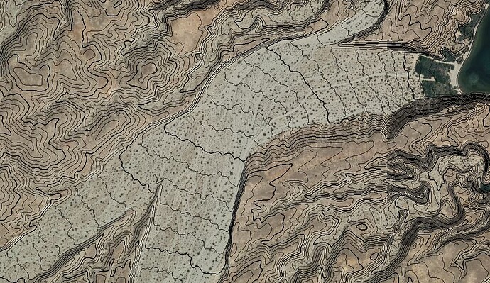
With an actual wadi, the banks are notably distinct from the broad, flat area of the feature. Here’s a picture to illustrate that:

If you look closely there’s a track through the wadi in this picture, which can give you some idea of the scale of the feature. The banks are steep and well-defined in contrast to the broad, flat area of the wadi. These can easily be mapped both from aerial imagery and from the overlayed topo contours.

Unfortunately, this particular wadi is currently mapped in OSM as natural=wetland. Which, clearly, it is not.
5 Likes

Thank you for the explanation. Might we say, an ephemeral river – from the looks of it, I’d think so!

1 Like

That was something we debated in the original thread. It seems that some wadis might be like that when they flood and others are quite different.

Your not suggesting changes to the waterway version. Why is there a need to create another version under different top level key? It is basically a dry riverbed so it must be created by natural cases. Otherwise it must have been a result of run off from a farm or job site. Implying that there are no unnaturally created wadi.

Great idea Kai Johnson. I’ve been editing southern Morocco and the whole region is choked with ‘waterways’ that run for 2 hours a year. Excessive logging is perhaps another discussion, but the problem is you have to log/ignore a ‘ford’ each time a track crosses a dry creek. Tedious. It’s not a ‘ford’ imo – neither wet nor man-made – just an eroded dip in the track at most. It would be great of small wadis did not require logging a ford.
Like eskimos with snow, there are scores of names for ‘wadis’ common in Egypt. In Morocco a stream is an Assif and a river is a Oued (same root as wadi). But I think wadi is better know, at least with Brits. Some oueds will have very wide banks, but just a trickle down the middle, if anything. Very occasionally I see this correctly drawn but in my experience the course of this intermittent waterway down the middle of a wadi will change and braid from storm to storm. So it will never be accurate for long.

4 Likes

You might be interested in a separate thread: Imaginary fords

@Kai_Johnson I think You were also into a rock-glacier topic? I mapped some and during that I realized that key geological is much better suited and helps a lot in avoiding conflicts than key natural.

1 Like

Yes. I like to think of natural and geological as complementary. Where natural is good for the general, superficial form of a feature, geological says more about its true nature or origin.

For example, we have natural=bare_rock but geological=volcanic_lava_flow.

1 Like

That is what geologists file-under the term rock-glacier :wink: I wanted to suggest wadi put into geological key, but perhaps …

1 Like