A few days; Maxar is blurred on my ID editor. When will it be fixed and what is the reason?
3 Likes
What day will this problem be fixed?
In past I’ve not found any discernible quality difference between the Maxar Premium (if that’s the same as just Maxar) and ESRI (Esri World Imagery) but for an ever so slight offset differential. They are at least to my eye not perceptibly different.
2 Likes
Both layers vary in freshness from locality to locality, and Esri World Imagery also varies in resolution from region to region. The difference is stark in some metropolitan areas in the U.S., for example, where Esri has ingested 3-inch or 6-inch aerial imagery, far higher resolution than satellite layers can provide. Maxar is much fresher in most of those places. But in Southeast Asia, I’ve found that Esri relies heavily on satellite imagery, so it’s typically not much different than Maxar.
In past did some viewing in the US and was astounded by the focus and detail, trees in winter where one could sharply distict the individual branches to include those closest to the ground.and thought why on earth is that not on offer here. Only BING here looks lots better than Maxar/ESRI but has a bad and inconsistent offset, even a twist.
1 Like
Only Maxar knows if, and when, this will be fixed. It isn’t a big secret that the way keys are made available currently doesn’t really work and only provides a superficial barrier to misuse.
7 Likes
There has to be a long-term solution. The API key updates do not carry over to Potlatch 3 automatically.
1 Like
I suspect that step 1 to that would be “first, launch your satellite” ![]()
3 Likes
More seriously, the specific Potlatch issue is mentioned here.
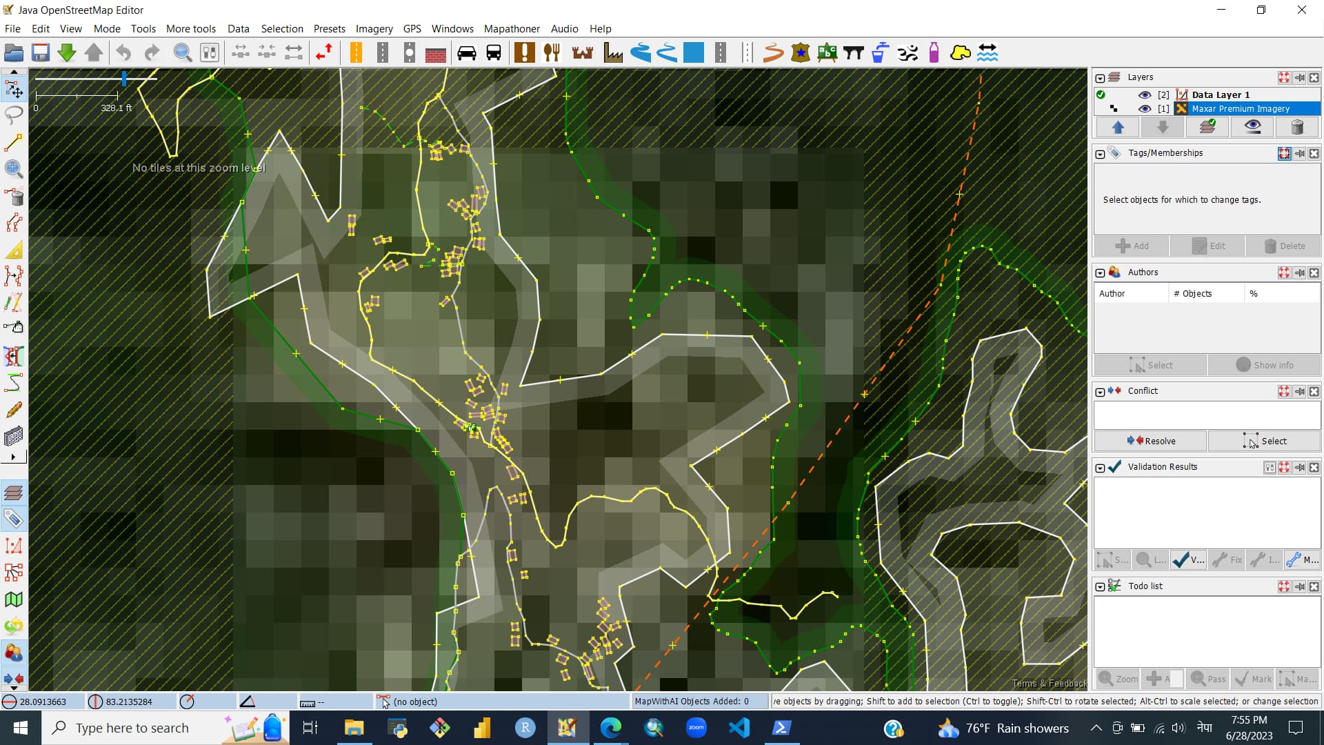
Getting this imagery error in the JOSM for the past few days. I tried everything people suggested to do but the imagery still shows error. Can anyone tell me how to fix this?
3 Likes
See #23025 (maxar tiles cannot be downloaded - invalid connect ID) – JOSM
(currently nothing can be done as an user, JOSM developers are waiting for updated key for Maxar imagery)
2 Likes
JOSM is returning errors instead of tiles for the “MAXAR Premium Imagery” tile layer today.
Are other experiencing this? If not, what is likely to have gone wrong with my internet connection?
Error message:
Error downloading files: Login failed - an invalid connect ID was specified.Credentials[username=null, connectId=((something that looks like a unique ID))]
The api keys have been invalidated and new ones haven’t been distributed yet.
12 Likes
See Maxar imagery not working (was "Maxar is blurred in ID" and other similar topics) - #7 by SimonPoole
As an editor who likes to work on remote areas, this is quite a massive hit.
Maxar was my go-to most of the time.
I’m not quite active here and mostly read the weeklyOSM news, so not sure if I missed something, but is there some effort from the Foundation or community to obtain reliable imagery for those remote areas?
I’m sure that this is not cheap, but maybe we can get some kind of fundraiser if there is a deal?
2 Likes
This is going to cause plenty of problems in Zambia, it is the go to imagery there as it is the most up to date by a long way. I fear new contributors to HOT projects will start to delete items mapped previously using Maxar that do not appear in other imagery. This is particularly so around large towns and cities where development is fairly rapid.
1 Like
Maxar imagery is a great resource that many mappers appreciate. It is useful in many places; crucial in some.
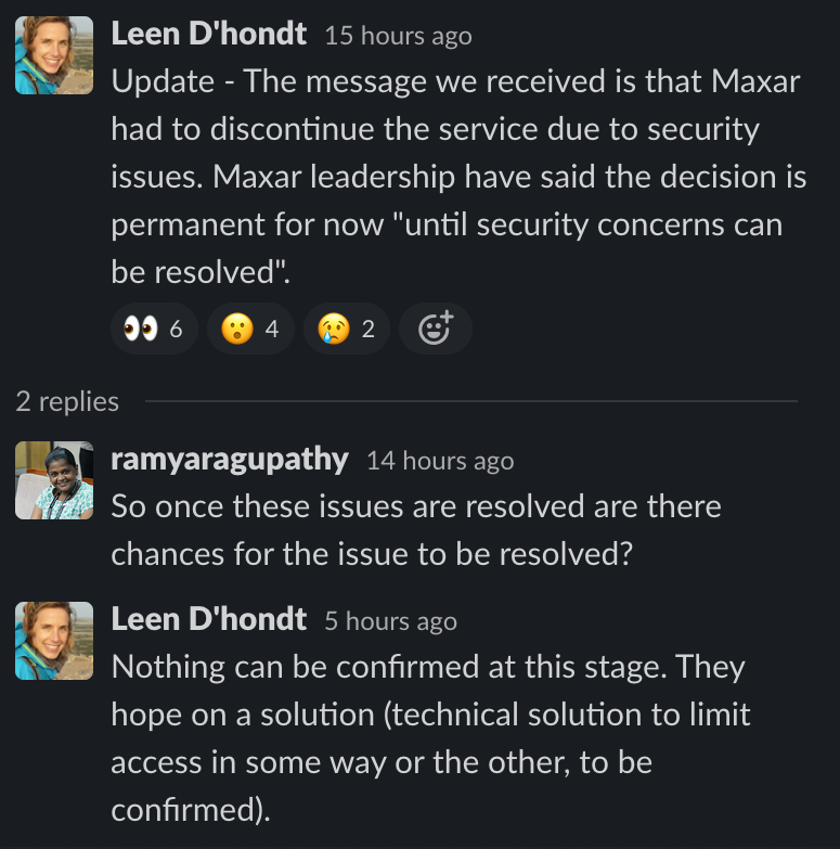
We’ve been in regular touch with them about API key rotation and other security mitigation efforts. We understand their concerns that a small number of people are using the OpenStreetMap API key to steal imagery for use for non-OpenStreetMap usage.
We have not heard much from Maxar on the current situation, but are trying to connect and resolve the issue.
14 Likes
I have seen pricing of about 10 $ / square kilometer. And license of imagery data would be anyway incompatible with OSM and would be impossible to use it for mapping.
No idea how much they would charge for commercial access on special rules allowing use for OSM mapping. And data storage rules required by commercial entities paying for it are quite strong, to the point that each mapper would likely need to pay for own access.
So about 10 $ / square kilometer for each mapper?
2 Likes