Natürlich!
Gott bewahre! Selbstverständlich nicht!
Entschuldigung, falls es blöd rüber kam.
Natürlich!
Gott bewahre! Selbstverständlich nicht!
Entschuldigung, falls es blöd rüber kam.
Discussing complicated questions with people in the same language is already challenging enough, I think but this example below shows that even (or especially?) with help from translators an extra dimension appears:
for this sentence in #45:
bleibe aber dabei, dass für mich eine Böschung und ein Deich unterschiedliche Objekte sind
the Dutch forum translation says:
, maar ik blijf erbij dat voor mij een dijk en een dijk verschillende objecten zijn
Deepl translates this into:
, but I maintain that for me a dike and a levee are different objects
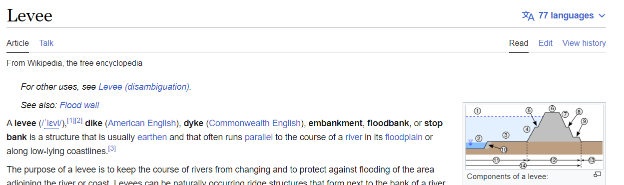
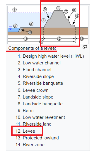
While Wikpedia states that dyke, levee and embankments are synonyms… ![]()
Another reminder for myself as well to take each others good intentions as a starting point when making any assumptions ![]()
Are there perhaps any native English speakers / embankment specialists that can help out here to get a shared starting point of the terms used here?
I’ve been trying to understand the relation between the terms below, and so far my view is:
see https://en.wikipedia.org/wiki/Levee (above)
and oxfordlearnersdictionaries :
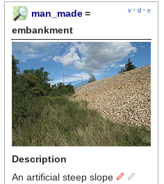
embankment: a wall or bank of stone or earth made to keep water back or to carry a road or railway over low ground
See: UK Enviroment Agency
An embankment is an earthen structure used in the fluvial, tidal and costal environments for flood defence and/or erosion protection. Also covers embankments used in dam structures.
And also:
Thanks for your views on whether this is the most correct and common usage of these terms.
Just to be clear - the terms that they use appear to be terms with a specific meaning within the processes that the EA uses when building flood defences. At best, some of them are adaptions of general English Language terms. For example “berm” normally means “long linear pile of something”. Here is an example within OSM that follows that general usage. A different specialist usage is here, where it’s been used for a specific constructed feature. Corporate language evolves like that and sometimes is no longer intelligible to someone not familiar with an organisation’s “dialect” (as an example, think about the “TPS Reports” in the movie Office Space).
I wouldn’t use words that the EA has used that also mean something else in more general language, I’d pick something else.
Underscoring the tone of what I believe is clearly everybody’s best intentions: it is terrific when people discussing something relatively complex (dykes, embankments, berms and how they might be improved with OSM tagging and eventually rendering…) do so knowing that there are cultural and language challenges AND that all here go out of our way to both recognize that and respect that.
It does appear that there is “a great deal of light and almost no heat” in this discussion, and I write these words to simply congratulate everybody on excellent communication in our endeavors to achieve consensus: “nice job so far, everybody.” I can see the dedication and deeper levels of understanding and “transmission of thoughts” between ourselves, and it is good. Words in cyberspace in multiple languages can be fraught with difficulty, yet we overcome these difficulties quite well right here and now. That only happens with good intentions, which it’s clear we are extending. ![]()
Yes, you are right of course that you must keep in mind in which context terms are used. And in the quoted text the EA in uses a narrower definition of embankments than we would do here (they only consider what we would call dikes embankments and exclude other types of embankments such as those that support a railway or that are build next to a highway to reduce noise pollution).
But for now I think it would help us forward if we could agree on the scope of and relations between the terms mentioned below, even if it is only for our discussion here and possible related proposals and wiki-edits in OSM.
This could help prevent misunderstanding that could arise when we have different interpretations of terms and their relations.
So here is a second attempt (from a non-native speaker), please anyone: feel free to coin a better variant if you can improve this text or to support this text with a thumb in reaction to post. Cheers!
===
Proposed working definition for usage in this discussion
( source: https://en.wiktionary.org/wiki/embankment )
embankment: a long mound of earth, stone, or similar material, usually built for purposes such as to hold back or store water, for protection from weather or enemies, or to support a road or railway.
A dyke / dike / levee / stop bank is a specific type of embankment to control the course of water and/or to protect against flooding
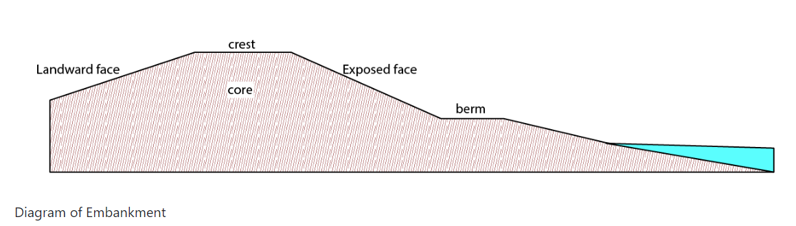
The scope (outline / circumference) of the embankment is the total of the slopes and the crest
(so not just the slope or just the crest)
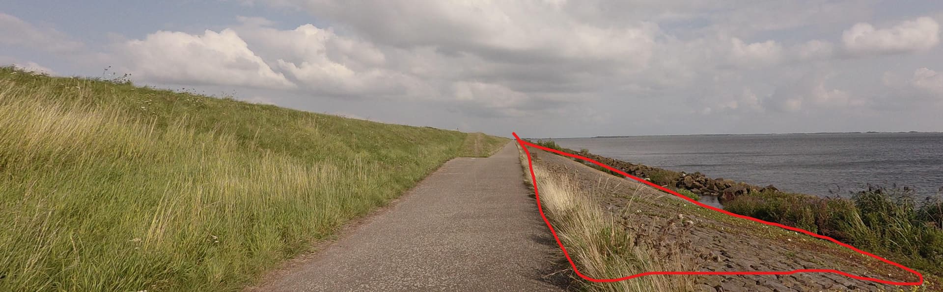
Part of this has already been done in this case: some parts of the embankment slopes where reinforcements are visible, are mapped as man_made=embankment. What I would like to see on the map, is e.g. how much flat field there is between the railway embankments; whether the serviceroad is beneath the rrailway embankment or half way on the slope; where on the slope of the canal bank the road and the cycleway are and whether (and where) there is an elevation difference between the road and the cycleway.
Using separate slopes with (where it counts) an explicit lower end line makes this possible.
Where it counts, that’s up to the mappers. In this showcase I think it counts, because it’s near my residence and I know the map does not even begin to reflect what it is like over there. In other places I might think a crest line is enough, but others might disagree; then they can add more detail, eg add slope toe lines. Then another maper may want even more detail, by breaking down a cascading slope into separate embankment slopes.
I know we should use British English, but I do wonder if we should have avoided d[iy]ke and used levee instead.
Note that the stepped profiles described here can also be seen on many dam structures (to add to the list of slopey things we map).
You are right and I apologize for writing this short reply in german language which I normally don’t in an english topic. I was some kind of surprised by the comment to my last post and tired as well so I didn’t even notice having written in german, sorry for that.
In regard of the terms used in this discussion you are absolutely right: very confusing indeed and the major problem is the multiplicity of meanings of “embankment” as I have already pointed out here. In a common dictionary you may find some 30 different meanings for “embankment” in german language - just a hint on how wide the definition of embankment is spread.
This is also reflected by the description in the wiki:
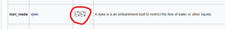
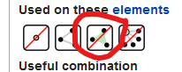
however a well defined tagging scheme for describing the different elements of an embankment and their relations is not yet available. For the area of the slopes the non-documented tag man_made=reinforced_slope is sometimes used but this is not explicit in the direction of the slope.
To add some more confusion, tagging of embankments is not consistent. On a raised road or railway you can add embankment=yes as a single tag for the whole object. You can also add 2 lines to the left and right to tag the slopes on both sides individually as man-made=embankment. So once the embankment includes the whole substructure of the raised way (or dyke as well), next the embankment is nothing but the slope on one side (or even not more than a part of it).
Therefore I appreciate your idea to work on a consent on how to define the different terms before new tags will be created. The definitions you propose here seem a good start to me. Documenting the definitions in the wiki should be the second step to achieve a “well defined tagging scheme”. Without such mapping of embankment of any kind will always remain unprecise.
I think embankment=yes doesn’t map the object. It tags the road as lying on an embankment, without specifying anything about the embankment.
man_made=embankment actually maps the upper line of an embankment slope, without any further information. Of course, attributes of the embankment slope could be tagged on this line object. E.g. if it’s reinforced from the top line down, you could tag reinforced=yes. You could add the angle of the upper side of the slope (which would be much appreciated by me, because of my fear of heights).
This is the same as:
It tells you only, that it is there, but not where it is on the slope. Which part is reinforced.
Look at building, which is in the base, man_made=building, there we use building= and building:part
With man_made=bridge, there we use bridge= and bridge:structure, bridge:support.
How are the various components named. Use the same method for man_made=dyke
dyke=
dyke:part or other component key typename (:structure :support) and a component value.
A line or a polygon. Line relations are too difficult.
Now, people used a own man_made (base tag) to express a part of the dyke.
man_made=reinforced_slope
Which is not correct (?), it is part of the dyke, also on the right the poured stone has a flood defence function, as part of the dyke, partly under water.
I did not talk about that - I just wanted to point out, that the meaning of the term embankment in real life can be used for the whole substructure of a raised trafficway or a dyke and at the same time for one of the artificially created slopes one one side or even part of such. That makes it difficult to use this term in OSM imho.
That is what most mappers do, other use this tag at the toe liine or may even place it in the middle of the slope. There is no explicit instruction in the wiki about this.
The wiki says to draw the line so that the downside is to the right. And that is how it is mostly used. A toe line mapped as man_made=embankment would indicate a further slope down, which is not correct, because then it wouldn’t be a toe. Man_made=embankment is sometimes even used in the wrong direction, so that the arrows point upwards, which puts it on the map but is clearly not consistent with the stated intention of the object/tag.
A line where the slope becomes steeper, that could happen especially where reinforcements are used, and that could merit a separate man_made=embankment line. A plateau, if it is important enough to map, has a toe line of the upper slope, then another embankment line for the lower part. Again, mappers decide how detailed they want and can map in each particular case.
If the plateau is a road or cycleway, I think I would not bother to map upper and lower slopes. Same for regular long stretches of standard dykes/levees, which all have a plateau (banquet) between crest and toe. But in the showcase above I would map upper and lower slopen, e.g. where the combined railway embankment rests on the even wider embankment beneath the whole complex, which then ends somewhere on the bathtub floor, and I would also indicate that “landing line” with a toe line.
This way, regardless of naming or official /technical component mapping, very complex setups can be broken down and mapped reasonably accurate, in a way that enables effective rendering. Existing landuse/natural mapping is not touched, it just adds information that is currently missing.
It does not get in the way of even more detailed mapping where more parts of the construction are mapped separately. And, it even enables mapping of areas between the high and low edges, where the crest and toe lines can be rendered as themselves, and the area can carry other attributes such as name, material, surface, angle, height,…, and can even have other areas within, such as areas of wood, allotments, meadows, partial reinforced_slopes.
I did a small test to see how an embankment slope area could work:
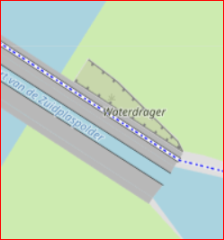
This is an embankment under an aqueduct, that’s why it is triangular. I had no renderings for special lines, so I used the upside down man_made=embankment to get an impression. The left side of the triangle is a toe, and I gave that a non-renderable tag.
The whole area is tagged as natural=scrub (it’s actually rough grass), and I gave it the name of the aqueduct. I actually think it doesn’t look that bad, even though it could still be a pit instead of a single slope. The upper line looks fine. Imagine that the lower parts of the outline would look like a thin line with some shade at the slope side, I think it would give a good impression on the map.
I honestly don’t understand that.
“man_made=embankment should be added to a way drawn with the lower side on right side of the way’s direction.” Klang für mich immer eindeutig nach der oberen Kante.
… an there ist no lower side!
and in the middle of the slope there is not only a lower side, but also a higher side. So it can’t be visible either.
Misapplied mapping/tagging should not be the basis for making the description in the wiki even more complicated and confusing. It should rather be a reason to make the description in the wiki clearer and more concrete. Incorrect application must also be clearly described as incorrect.
Btw. I don’t like the edits to the OSM wiki on man_made=embankment that have been made this month. They are too detailed, cause confusion and I think one thing or another is not described correctly.
A berm is not exclusively
The extent of horizontal ground between the watercourse or coast and a raised feature.
A berm can also be halfway up a slope. Berm is also a word with many different meanings. And probably different in the Netherlands than in the UK or Germany.
The German Wikipedia says:
A berm is a horizontal piece or ledge in the embankment of a dam, rampart, excavation, quarry or on a slope. It divides the slope into two or more sections. A berm is designed to reduce the earth pressure on the base of the slope. An embankment with a steep slope and berms is more stable than a continuous embankment without berms. Slope failure is thus avoided.
next point
the word used in the OSM-value for man_made=embankment typically refers to the embankment as a whole (sloping parts and the crest), but the focus in the descriptions and images used focus on the sloping part
embankment=yes on a highway or railway refers to the crown - yes.
As far as I can remember, man_made=embankment always referred to the edge between the crest and the slope. The rendering also follows from this: a line and markings (triangles, semicircles, small lines at right angles …) on the sloping side. Comparable representations can also be found on historical maps.
- the instructions in “How to map” refer to a line with a with a high side and a low side, without making explicit if this is (a) the toe at the base of the slope (“face”) ; (b) the crest at the top of the slope or (c) both ;
That was never misleading for me. It must - for me always - be b). Since the rendering is comparable to natural=cliff, you can compare it with the description there:
If the cliff is not perfectly vertical the way should be located on the top edge.
If the previous wiki was misleading, it should be clarified as with natural=cliff.
however a well defined tagging scheme for describing the different elements of an embankment and their relations is not yet available. For the area of the slopes the non-documented tag man_made=reinforced_slope is sometimes used (Taginfo) but this is not explicit in the direction of the slope
That is correct. So back to what Peter wants: a simple tag marking the bottom of a slope.
KISS - Keep it simple, stupid!
Can be used for all kinds of embankments, dykes etc. Easily recognisable by the mapper in most cases, without the need for a mapper to have expertise in dyke construction, embankment construction, dam construction. Without knowledge of technical terms.
I fully agree with you in most of your points. What I tried to express is that the description to embankment in the wiki is poor and should be enhanced:
You may understand that this defines the upper kink of the embankment but it is not explicitely stated. An embankment is an area and if the area is represented by a way (bacause auf reasons of simplicity or else) that way could well be in the center of the area as long as the indicators shows the correct direction of the slope.
I do not say this is correct, I just pointed out that people can misunderstand this. And again it is not my idea that other mappers may draw the way at the toe line of the embankment:
and moreover the wiki also reflects this (see your own quote). Again I do not say this is correct, I just pointed it out.
Your idea that man_made=embankment always referred to the edge between the crest and the slope is reflecting the OSM tagging practice in most cases (although not clearly defined as such in the wiki).
But the text you quoted from the wiki talks about the meaning of the word embankment in real life where an embankment ist mainly understood as the whole structure beneath a raised traffic way from the crest down to the ground and then points to the fact, that in OSM the word embankment is used with a focus on the sloping part only (by the descriptions used and images attached). It is just a criticism on the poor definition of the term “embankment” in OSM which is one of the points in my earlier posts as well.
Thank you, this is exactly my point.
Please consider the possibility that other people don’t want to be KISSed by you.
Personally I first interpreted the text
man_made=embankment should be added to a way drawn with the lower side on right side of the way’s direction
also as to draw a line on the high end of the slope.
But then I saw several large embankments with man_made=embankment also around around the toe of the embankment, then I read the text in the wiki again and came to the conclusion that the tagging instruction wiki does not exclude this : when looking perpendicular at the toe line, when you move away in both directions, one direction is lower compared to the other.
This might for most people not be the first way to read the tagging instruction (it was not for me), but if you would only allow it only to the high end of the slope and consider all other uses as incorrect, you are left with a much worse problem:
If you draw a line around a simple embankment like a sound barrier, with downward slopes on all sides of the crest -only around the the top the slopes-, you would draw the circumference of only the crest, and leave out all the slopes , while the definition in the wiki and images focusses on these slopes :
This while the feature that man_made=embankment aims to describe is normally regarded as the sum of crest+slopes.
So with this narrow approach of what current man_made=embankment may be used for, it is actually representing man_made=embankment_crest , which would be a very confusing choice for a tag name and tagging instruction.
That is why I would ask again to please respond to my earlier question on whether you agree to these working definitions or if you have a better alternative.
Because if we don’t agree on the scope of definitions we can have endless debates and not get anywhere, and that would be a waste of time.
No, it doesn’t, if you consider the whole wiki text and examples. I have altered my opinion on this point, and no longer think the wiki supports the option to use man_made=embankment on a different line than the top line of one slope of an embankment. I think the intention is clear, and most mappers understand this and use the object as intended. I do think the wiki should be made more explicit on this point. Which I will not do during this discussion! It would give the impression of retrofitting the wiki to enforce my preference, while I am, on the contrary, keen on keeping the current usage, based on this wiki, unchanged. I just want to offer renderers the option to improve their rendering, and renderers who do not want that should not have to do anything.
I think the “overwhelming minority” of uses based on a different interpretation, will stop once an easily renderable alternative (to map the end of an embankment slope) becomes available.
Or, the feature that man_made=embankment aims to geotag is de top of an embankment slope, also to be used for one-sided embankments, so a two-sided embankment needs two lines, one for each side of the crest. The lines indicate positions of the artificial slope tops, but not the extent or area attributes of slopes. This is all standard stuff in OSM, where a road is represented by a single way, a parking lot can be represented by a single node, etcetera.