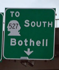
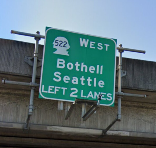
The tags currently used for state routes in Washington are inconsistent with the real world names. Routes like SR-527 are named “WA 527”, using the WA prefix. The “WA” prefix isn’t used on any signs, on the WSDOT website, or any other official documents I can find. There are random websites that use the WA prefix, but they are in the vast minority. This incongruity between the existing tags and the real world is causing confusion with navigation and editing.
I think the tags should be adjusted to match the real world, and use the “SR” prefix, or spell out “State Route” so navigation programs like OSMAnd give accurate instructions. If differentiation is required to prevent conflicts with roads in different states “Washington” could be spelled out ahead of “State Route”.
That should be fine as long as the Washington community agrees on it, more of an “to each their own” approach for ref tags among states is a good thing.
The next step would be to invite other Washington mappers to this conversation. For the benefit of those who aren’t as familiar with the state, also consider posting some representative examples of real-world usage – not just from WSDOT, but also from the media or other sources from the general public.
I think it would be more of a pain to change from WA to SR in the ref tag. As it stands, on highway=* objects there are far fewer instances of ref~SR than ref~WA (from overpass turbo):
I’ve actually been meaning to clean up the segments that use SR instead of WA but I haven’t gotten around to it.
I understand the argument that it more closely matches what’s “on the ground” but this is a fairly easy “OSM-ism” to learn (in my opinion) and it’s well documented/used in other places. There’s even this mention on the OSM Wiki page for the ref tag:
In the United States, some of the most popular ref formats do not correspond to what’s on the ground, due to historical technical reasons. For example, Interstate highways are tagged e.g. ref=I 75 instead of ref=I-75, and some states use postal abbreviations instead of more ambiguous, human-readable prefixes such as “SR”. However, this Sophox query demonstrates how a data consumer can automatically generate human-readable refs using the network=* tag on route relations.
Anecdotally I’d say most folks I speak with (I live in Seattle) refer to state highways by their number (“522” or “highway 99”) rather than saying “SR 520” or “state route 167” conversationally.
I agree that most people just use the number in regular conversation. Is there anything preventing a batch edit to correct the tags throughout the rest of the state? The argument of “we’ve always done it the wrong way so we should stick with it” doesn’t seem like a good reason to keep the format unless there is some major issue that a bulk correction would cause.
Yeah I’m sure a batch edit could be done, my concern is mostly with updating/notifying all the data consumers who may expect WA and not know how to handle SR (I’m not sure if such an edit has been done yet for any other states). Also to consider is the task of documenting/socializing/retraining such a change to long-time highway mappers, which seems more daunting to me than new mappers figuring out the current convention (but I may be mistaken about this, I just feel like new things are easier to do in OSM than changing old things).
If we feel the benefits of a more “on the ground” tagging scheme outweigh the resistance to change then that’s fine by me honestly, just wanted to make clear that I believe it to be non-trivial.
Since the discontinuation of the MapQuest Open renderer, there should no longer be any software that depends on these state abbreviations. @Minh_Nguyen wrote up a more detailed history of this issue here.
This is a fair point. Aside from Mapquest which @clay_c mentioned is discontinued are there any other large providers that might be impacted? As @Minh_Nguyen mentioned we should get other mappers opinions on this, are there any good groups to notify?
For what it’s worth, I think the standard should be what the public uses formally rather than conversationally. In any state where numeric conflicts are rare, people will tend to drop the qualifiers in conversation, because that extra context is unnecessary. I don’t think this should necessarily dictate our tagging. By analogy, people habitually refer to “Main Street” to just “Main”, but we still tag “Main Street”.
Thanks. The reason I brought up public usage is because some state transportation departments have their own internal designations, or their official designations haven’t caught on with the public at all. A good example is California’s “SR”, which is official but probably confuses motorists whenever they see it on a rare sign. Few Californians even know they’re called “State Routes” as opposed to “Highways”.
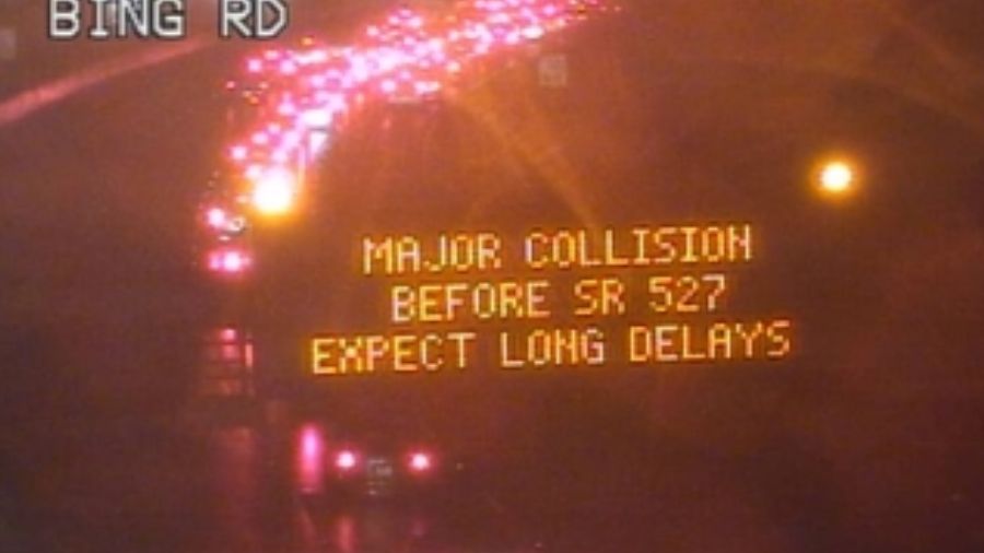
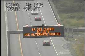
These photos of dynamic message signs show that WSDOT expects motorists to understand “SR” in situations where they must post the route number as plain text.
Although MapQuest Open was the main driver of the state postal abbreviation adoption in OSM, some other data consumers later introduced dependencies on these specific abbreviations. Here are the ones I know of:
Mapzen’s house styles chose state-specific shields based on these abbreviations. Mapzen itself is defunct.
The Mapbox Directions API can optionally return a state-specific image based on parsing a prefix out of a way ref. This image is meant to be displayed in the UI alongside the name of the upcoming exit. Generic prefixes like “SR” are supported, at least in some states. Anyways, Mapbox has introduced a newer API that no longer distinguishes between states. Only the iOS version of the Mapbox Navigation SDK still uses the old API, as a workaround for the lack of state-specific shields in the new one.
Valhalla expands postal abbreviations into full state names in guidance instructions meant to be read aloud by a text-to-speech engine. Fortunately, it also supports the generic “SR” abbreviation. If you think “state route five twenty-seven” sounds better than “Washington five twenty-seven”, then “SR” is your prefix.
Some other data consumers like OsmAnd and Mapbox Streets also match known way ref prefixes to choose shields, but they don’t care whether state routes are tagged with state abbreviations or something generic like “SR”, because ultimately all the state routes get the same generic shield.
Indiana’s experience makes me optimistic about a smooth transition. Usage of “IN” went from zero around 2012 to 65% in 2014 to 91% in 2019, but “SR” never completely went away, especially in the southeastern corner of the state. A given route would switch back and forth repeatedly, which was bad for everyone. With an admitted bias for “SR”, I manually fixed all the inconsistencies in southeastern Indiana by changing “IN” to “SR”. I tried to start a conversation about aligning on a single prefix across the state, posting on this forum, the wiki, and Slack, but the only response I got was that, soon enough, another local mapper finished off the rest of the state while I wasn’t looking.
I’m unaware of any serious fallout in Indiana over the past five years, other than the occasional out-of-state mapper getting confused and reintroducing “IN” haphazardly on some exit ramps. We’d need to update the route shield field guide, which mapping teams rely on as training and reference material, and a few other pages around the wiki. Otherwise, I don’t think there’s a great deal of risk compared to other kinds of tagging changes. After all, just about every renderer that varies shields by state already supports route relations. But moving off the postal abbreviations would send a clear signal to developers that they shouldn’t create something new that tries to parse way refs, even for something more predictable like an Interstate or U.S. Route.
By far the most common thing is no sign at all: signposts only carry the name of the intersecting street. Presumably this is on the basis that state highways are so important you’ll be able to identify them by reputation alone.
In cases where it is signed, my sampling suggests that “State Highway” or abbreviations thereof is more common than an “SR” prefix. There are also hybrids such as “SR 902 HWY”.
Are these street name signs that local authorities put up? I’m not sure we should base any tagging convention on local street name signs. Anywhere in the country, they tend to be so wildly inconsistent that we’re left just mapping the signs themselves. I realize this consideration undermines the goal of tagging for wayfinding, but it’s a much larger problem than numbered routes in one state.
Which of “WA 902”, “SR 902”, or “SH 902” would be the least surprising on something more prominent, like for instance, a dynamic message sign about an incident or traffic times? Does the signage practice vary by WSDOT district?
Here in the Spokane area, the only roads that consistently get mentioned on dynamic message signs are I-90 and US-2. There aren’t any signs positioned to talk about 902 or 904, 290 and 27 are referred to by their street names of “Trent Avenue” and “Pines Road”, and everything else is too minor.
The last time the Keller Ferry was out of service, the newspaper referred to it as “State Highway 21”.
I wonder if that’s the result of influence from Idaho. ITD formally refers to their state-designated routes as State Highways, though apparently other monikers are common enough:
SH
SH stands for state highway or an Idaho route. SH 55 is also referred to as Idaho 55 or ID-55. The Idaho Transportation Department (ITD) takes care of interstates, U.S. routes and state highways (SH) in Idaho.
For its part, WSDOT headquarters seems to distinguish between state highways as infrastructure that carries state routes as designations. (I’ve lived in two states where the DOT the same distinction.) And SR is the standard abbreviation in that case. But regardless, I think the real question is whether “WA 21” or “Washington 21” is the most suitable form for data consumers to present to users in text or voice guidance, whether by regurgitating what’s in the way ref or by pretty-printing the route relation’s tags, since parsing way refs has been frowned upon for ages.
If Washington is going to change from “WA” to “SR”, it should be a nationwide change also tbh. Most of the other states use their state abbreviation for their state highways, including all of the state’s western neighbors, why should Washington change? If the argument is that the signs don’t say “Washington”, I would only agree if the majority of signs within the state were not shaped with George Washington’s head.
I can offer anecdotally that as a Washington resident I find the WA/Washington designation confusing as I’ve never seen that used. I informally asked a few friends what the highway through Aurora is and all answered “SR 99”.
A link to this thread has been shared in OSM US Slack’s #local-washington-state.
To keep the change set from being too large keeping it on a state by state basis would be best. Unless all the various state mapping groups get on board. A bunch of states use different prefixes as documented in this table that @SD_Mapman made
Interestingly though, Oregon’s DOT does seem to use OR ### as its abbreviation for its state highways, so I’m not sure this is an apples to apples comparison.
That’s not really the argument I’d make though… it’s more about the fact that the “WA” is contrived. As you’d see from these historical discussions, proponents of the postal abbreviations cited the following rationales:
Every state would be consistent. But we could never achieve that consistency because the tradeoff wasn’t a good one in every state. OSM is not really the project someone would enjoy if database consistency were the overriding goal.
You can quickly glance at the map and know what state you’re looking at. But this is actually an argument for appending postal abbreviations to place names, where they normally belong. If you need to know what state you’re looking at, you can simply right-click and choose “Show address”.
MapQuest Open detects the “WA” and puts the route number on a bust of George Washington. But even back then, we wanted renderers to look at the route relation’s network=US:WA tag instead. This is what “Don’t tag for the renderer” is all about, but we were desperate to have accurate route shields like a real map. Nowadays, we can have those shields without distorting the ref=* key.
Yes, many states do actually use their postal abbreviation in practice. No one is going after those abbreviations.
The only national standard we’ve ever had is that every state does it their own way, which might be to adopt a postal abbreviation or to adopt whatever is common sense locally. Not for lack of trying: I count dozens of attempts to start a national conversation about enforcing a national standard, and here we are.