A new layer “Tracestrack Topo” has appeared on OSM (at least on iD) this morning
Looks good, but does anybody know anything about it?
A new layer “Tracestrack Topo” has appeared on OSM (at least on iD) this morning
Looks good, but does anybody know anything about it?
Looks like it’s from here: https://www.tracestrack.com/ and here’s where it was added: Add Tracetrack Topo as featured layer by pnorman · Pull Request #4255 · openstreetmap/openstreetmap-website · GitHub
That’s all I could find out.
It’s so new, it’s still not documented, after I checked yesterday Featured tile layers - OpenStreetMap Wiki
I want to know who should I contact for network problems, that persists on their own website. I don’t care about their official service yet. Only need to be viewable on this side. Ie would requesting from www.openstreetmap.org avoids the blockage.
If you’re not seeing the tiles then it’s probably not a network problem - you probably have a browser extension that is faking referer headers and it won’t serve tiles if the referer isn’t openstreetmap.org.
The cause is OpenDNS. Using it, I have NS_ERROR_CONNECTION_REFUSED , with Referer: https://www.openstreetmap.org/ . On their own Map Explorer too.
The Tracestrack map is also available on a standalone website.
I noticed that they render highway=busway. This is very good. It fixes a long-standing problem with the maintainers of OSM Carto.
Thanks for the hint, I like the design. Note that the layer is not added to iD but to carto.
<aol>
I like the busways too.
What does this mean?
I had to look this up too. Apparently it means “I agree,” not this:

Anyone knows whether they have public issue tracker?
<aol> refers to the ancient habit on the America OnLine billboards to post lots of agreeing replies (thumbsups, likes) with no added content. Other messaging systems looked down on that, but at the same time started to use “<aol>” for exacty the same purpose. Some niche forum members still use it, sometimes, mainly to display how wise and old they are. Others probably would see that as totally outdated…
Nothing on the side of sac_scale, trail_visibility and so on.
Where can we send bug reports?
There is an issue tracker for the label overlay but not for the base map as far as I can tell. The TracesMap website lists info@tracestrack.com as the e-mail address to contact.
I really like this map style. It’s a nice evolution from osm-carto: not too different from it, yet looking more modern. Also, the high-DPI tiles look nicer on my phone.
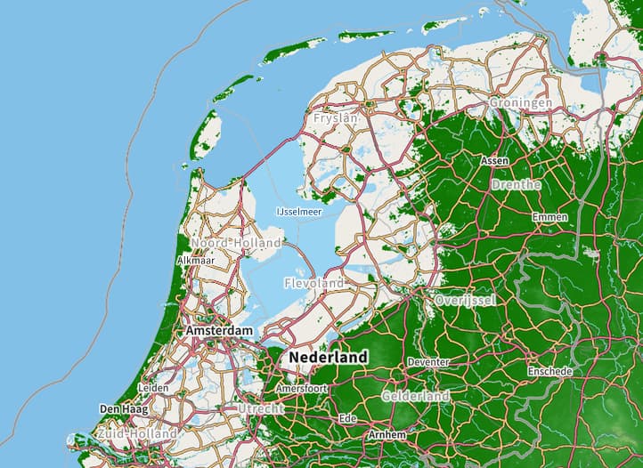
One thing I don’t like is the elevation coloring on zoom level 8 and below. It is really prominent and distracting in my opinion, plus it doesn’t properly handle areas below sea level (i.e., half of the Netherlands is gone). I think I’d like zoom level 8 and below much more if they’d just use hillshading but no coloring, like level 9 and up ![]()
Map shows paths with solid lines & tracks with dotted lines! WTF? IMO useless for outdoor purposes as it is contrary to common sense and the current OSM Standard Map.
Thunderstorm cyclemap (layer C) is quite good at this. Mountain paths and cousins there do not look like convenient walk-ups. The hill-shading also better tuned.
The source code is now available, and there’s an issue tracker too: