I am looking for a way of tagging training areas like this one of the German THW. The THW has multiple of these places in Germeny. These training areas are areas equipped with special buildings, ruins and objects like piles of rubble or old railway cars. Things that can be practised are searching and rescuing of people, breaking open concrete walls, building/repairing dikes, climbing walls and more. There are probably similar training areas for fire fithers, rescue dog units, medical first responders and so on all over the world. It would be nice to find a general tagging for these places.
The training areas can be combined with other places managed by the operating organisation but they can also be stand alone. They do not necessarily have permanent staff. There is not necessrily a teacher or fixed courses that you can visit. The training areas I refere to are in most cases just places where units of search and rescue organisations can practice their skills on their own. Only in some cases these areas are combined with some sort of school.
I am looking for something similar to military=training_area just for non military organisations. There is an old proposal for fire_service=academy that was never finished. But I am looking for tags for a training area of disaster responders/civil defense units. So neighter “fire service” nor “academy” fits.
Am I missing something or is there realy no established tagging scheme for such training areas?
Based on emergency=disaster_response I could maybe use something like disaster_response=training_area or a more general landuse=training or training_area=yes. But before I invent new tags I would like to know if there are already fitting tags in use.
We had a discussion about emergency services before Initial discussion: Possible new way of mapping emergency service areas & locations
The problem with disaster_response= as a feature is you prevent it from being able to be used as an attribute for emergency=disaster_response if needed. This consequence is seen in amenity=police from police= features.
Then you have to invent a set of =academy , =barracks , =helicopter_unit , =offices , =storage , and =training_area for every service. Results in many =training_area for each service, iedisaster_response=training_area , fire*=training_area , water_rescue=training_area , mountain_rescue=training_area , etc . There’s a further complication if different services share a facility.
Compare with how there’s no army= / navy= / air_force==training_area , but only military=training_area one unified. Then military_service= for the service.
There are a few ideas that could be used for all emergency services. It can still be improved if emergency= is not the best. emergency=training_area | Tags | OpenStreetMap Taginfo
In addition, there are spots on the outer edges of airports where airport fire crews practice rescuing from, & extinguishing, crashed aircraft, but they’re usually not even mapped in any way, or if they are, as e.g. Way: Fire Training Area (575390730) | OpenStreetMap (& no, I didn’t map it, I was only updating roads & fences! )
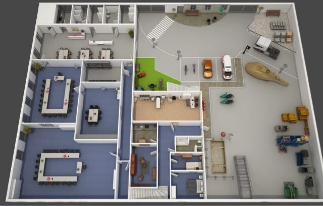
It’s a big building where the emergency medical services can do indoor training of all types of situation. The building is high enough that they can drive an ambulance in there:
I’ve used amenity=training + training=emergency back then, in lack of a better available tag. Even though it’s a training area, you can see from the picture that it’s also got conference rooms for teaching and planning. Would something like this fall under emergency=training_area, or rather under the forming education=*?
Coming back to your post, I don’t think either of these are a thing.
I was with a (blue water / coastal) Marine Rescue unit for many years, & any training was just done in a random area out at sea.
My wife is a skier & asking her, she also said the same about teh Ski Patrol units she has seen - if they are doing a practice run for the day, it’s just on one of the slopes / runs, not in a separately roped-off part of the mountain.
As far as I know, such training centers are fairly well established for the fire department. In Germany, fire departments are organized by the federal states, so that each state has its own training center. These are referred to as FAZ (Feuerwehr-Ausbildungs-Zentrum) for short. Some examples:
The ski patrol (Pistenrettung) definitely only trains in open terrain. However, for us in the alps, these are more of an advanced first aid unit. They are employed by the aerialway companies and are therefore not directly part of the public rescue services.
In contrast to this, the mountain rescue (Bergwacht) is the voluntary counterpart to this and they have highly modern training centers where you can rappel from a helicopter, simulate cable cars and so on. See some crazy pictures here: https://bw-zsa.org/
The water rescue service (Wasserrettung / DLRG) has training centers, usually one per federal state. But these are usually only sparsely equipped (more like a classroom), since the practical training takes place outside. Can’t find any good open&free pictures, but you can search for “Ausbildungszentrum der Österreichischen Wasserrettung Wien” for some pictures, at least attached to the Google Maps POI.
And of course the already mentioned training centers for the THW (Technische HilfsWerke “Technical Relief Organization”) mentioned from OP.
I don’t agree. emergency=* is used for objects that are relevant/get used in emergency situations. A training area for emergency-responders is different. It only has a relavance for the preparation for emergency-situations but in case of a real emergency it is absolutely irrelevant.
From my understanding, a training area and an academy are two different things:
An academy is a place comparable to a school. You can visit courses and get certificates for what you learned. The THW has such places, caled “Ausbildungszentren” (=education centers). If you are part of the THW you can visit this place to learn specific subjects from a professional teacher.
A training area is a place comparable to a playground. There is no teacher or anything like that. So if you want to visit such a place with your unit, you have to bring your own ideas for what to practice with you.
A training area can be next to an academy because for some courses you need them. But training areas can also be stand alone without much infrastructure around them.
That is probably because others didn’t find a good way of tagging eighter.
For me that looks more like an academy than like a training area. Is that right?
Maybe we need a tagging like that for tarining areas:
landuse=training for an area that is used for some kind of training.
training=fire_fighting;medical;rescue;... to specify what can be practiced there.
fire_fighting=airplane, rescue=water;high_altitude;... for a very detailed mapping. If there are no specific training areas for e.g. water rescue than rescue=water is not neccessary. But this tagging may possibly be much to detailed.
And additionally for academys we could use something like amenity=academy.
I’m not sure if “academy” is the right word for it. Different emergency services go there for training and workshops: firefighters, emergency medical services, THW …
landuse= is a homogeneous statistical classification, not exactly a unique individually identifiable feature. It’s only used when there is nothing else usable. training= already has amenity=training , which will be passed as education=training now. But it includes lecture-only learning centers, and needs at least eg access=private for these “in-house” internal training. =academy is yet more vague, and both features should be considered together somehow. education= actually had =exercise_area before, however not the clearest https://wiki.openstreetmap.org/wiki/Proposal:Education_2.0#Types_of_educational_institutions
Fundamentally, education= can only be used for teaching and practice. It can’t solve other supporting facilities, which only a few eg =storage may be considered in emergency= for the usability.
Anyway, t’s better to align with military= and police= (instead of education= ) , and =training_area (instead of =exercise_area )
Feature options
A. emergency_facility= : Too similar to emergency= ?
B. emergency_service_facility= : More verbose
C. emergency_support= ???
D. emergency= : The above aren’t promising at the moment. At the same time, the assumption that emergency= should only be used for emergency situations could be discussed. Currently, it can be described as “related to emergency services”, not only the vague “related to emergencies” Emergency facilities and amenities - OpenStreetMap Wiki
E. Or we have to consider limited fragmentation. This may have to be accepted somehow.
fire*= (I suggested firefighting= as the feature to the proposal, to reserve fire_service= for the units)
rescue= ?
EMS / Ambulance services
Other civil defense
Etc
Already quite many. Again, this won’t be suitable if we want to keep the possibility of unifying all emergency services.
In any case, the facilities can simply be distinguished by the organizations first
If needed, it could be distinguished by the training content. This should only be used when there’s a misfit, eg the fire services performing and training on other tasks.
A. Sub-tag: training_area= : Can’t be used on other features if needed. Requires one for each.
B. Unififed: emergency_activity= ?
C. Limited fragmentation: rescue_activity= ?
=training_area could be inside, adjacent (different perimeters connected together), or separate from =academy
The only example now are inside what’s currently a =collegeWay: Campus Vesta (112015591) | OpenStreetMap (inspect the non-rendered areas)
That being said, these small parts inside an =academy may need to be distinguished from large standalone ones.
Yours would be an indoor= detail if you want to draw it. Aside from this, the =academy could have eg training_area=yes , if there are urban ones for lectures only having =no
For reference only, the general education system was proposed to used education_service:*= to distinguish the form of teaching/learning in a facility Proposal:Education 2.0 - OpenStreetMap Wiki