Initial discussion: Possible new way of mapping emergency service areas & locations

During discussions about the emergency=disaster_response proposal, I had a thought, brought on by a couple of comments, about possibly completely redoing the way we currently map the areas and locations used by emergency services, as well as the way we tag them!

So, currently we map the various emergency services (Police, fire & ambulance) in different ways:

Police stations, and their land, are both https://wiki.openstreetmap.org/wiki/Tag:amenity=police?uselang=en, together with Key:police - OpenStreetMap Wiki for “other” Police-related features.

Fire stations are Tag:amenity=fire_station - OpenStreetMap Wiki, with their buildings as https://wiki.openstreetmap.org/wiki/Tag:building%3Dfire_station

Ambulance stations are Tag:emergency=ambulance_station - OpenStreetMap Wiki, but they don’t render on Carto, although the others do.

Here’s a spot with all three of them sitting side-by-side: OpenStreetMap

There is also https://wiki.openstreetmap.org/wiki/Tag:amenity%3Demergency_service for “civil protection agencies”

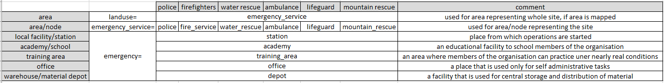
I would like to look at introducing a new tag of <landuse=emergency_service/s>, similar to Tag:landuse=military - OpenStreetMap Wiki, to cover the areas for all emergency-service units / bases.

Together with that, also copy https://wiki.openstreetmap.org/wiki/Key:military%20service?uselang=en, to show what particular service (Police / Fire / Ambulance) are there.

We could also include the Tag:military=base - OpenStreetMap Wiki & https://wiki.openstreetmap.org/wiki/Key:base_function layers to further define what goes on at any emergency-service station?

This could also be extended to include the various other Rescue groups covered under Emergency facilities and amenities - OpenStreetMap Wiki.

So, thoughts, comments & suggestions?

& yes, I do know that I am talking about potentially modifying 300k features! :grinning:

2 Likes

Are you saying that all emergency facilities would be primarily mapped using the landuse tag? Or is landuse in addition to other tags? How would this work for a small police station mapped as a node?

Also, would all police facilities be regarded emergency facilities? That feels non-obvious to me. Almost all my visits to a police station are for bureaucratic reasons like renewing an ID card. To me that doesn’t really feel like the same sort of thing as a fire station which primarily exists to respond to emergencies.

2 Likes

For me, what I asked is not about the homogenous landuse= paint to characterize these areas. It is the supporting features.

  1. There are shared facilities between different emergency services
  2. For dedicated facilities, I have doubts on whether it is necessary to have =academy , =training_area , and =depot / =storage for each emergency service eg fire_service= (I prefer firefighting= ) and disaster_response= . Proposal talk:Fire service - OpenStreetMap Wiki

There won’t be a change in the most common features =fire_station , emergency=ambulance_station , and =disaster_response for the duty station.
My thoughts for emergency_service= or fire_service= for the service comes the existence of firefighting units other than the municipal fire departments. Most commonly, wildfire by forest, land, or park agencies in North America. In transportation, UK has independent airport fire services, and notably the US has a unique example in Eisenhower Tunnel, Colorado.
Separate issue exists for non-militarized coast guards (not covered by military_service=coast_guard), where both amenity=coast_guard and emergency=coast_guard (ignoring seamark:type=coastguard_station) have been put forward. It’s not related to =water_rescue .
Technically emergency services may include police, but that’s not what I meant. In fact, I would want to ask about whether the concept of “law enforcement” should be used to extend police= to non-“police” organizations, especially ATF, DEA, and USMS in DoJ. DHS agencies are sorta mixed. USBP when considered as border guards is commonly policing in other countries if they are not military; while customs part of CBP is less police-like. Then there’s ICE.
Comments against the voted police= feature brought up the mismatch of national police:FR= for the police organization. While I suggested eg police_service= instead, this does brought up the lack of police= for what a amenity=police station is, from the organization or area headquarters, to local stations and kouban community or special police posts.

fire stations actually also do a lot of “bureaucratic” work, at least in those jurisdictions where they have a significant role regarding applications for construction (fire prevention, conformance with fire regulations).
I agree that “landuse” shouldn’t be the key for mapping features.

1 Like

If the facility is on it’s own block of land, then yes, map that area as landuse=emergency_service + emergency_service=*.

It would remain as a node, but tagged as emergency_service=police. Same if it’s a self-contained building e.g. the ex-fire station shown in Ghostbusters :grinning:, map the building as emergency_service=*

Probably not, as per the current amenity=police for “actual” police stations & police=* for other things, but the area of the landuse could still stay as emergency_service.

As are mine, but it’s still a “real” police station I’m walking into.

1 Like

Sorry, K, but you’ve got me a bit confused as to what you’re saying here?

We are talking about different aspects. That’s related to @dieterdreist 's opposition. I’m suggesting to follow military= features for all emergency service facilities. You are suggesting to have a landuse=military for emergency services, which is a statistical classification. It would be more specific than landuse=institutional .
landuse=civic_* is actually what’s proposed in Proposal:Landuse=civic - OpenStreetMap Wiki despite the title. Among them is =civic_safety . I don’t like the use of “civic” here, and it seems confusing with “civil”. Civil defense is another thing that’s not exactly the same.
Also related to police, there is landuse=prison that may be repurposed for multiple individual amenity=prison .That’s getting further away from law enforcement itself, but is still part of the justice process.

Ah, thanks!

Yes, I thought this was the main idea of having all of the various landuses?

Ok, you reminded me something. As there should be separate amenity=fire_station and emergency=disaster_response when they share a site, there is a need for alanduse= similar to landuse=education enclosing =school campuses .

Yes, I thought this was the main idea of having all of the various landuses?

landuse is not suitable for feature tagging, for one because features tend to be in buildings and buildings often have several floors or are split horizontally. And because we usually use different tags for features.
This doesn’t mean we could not have a tag emergency_service similar to how there is “healthcare” (which is tagged in parallel e.g. with amenity=hospital). I don’t think we should deprecate amenity=police or similar tags.

1 Like

you can have it, but it isn’t required. You could have the whole site tagged as amenity=fire_station (if it applies) and either have emergency=disaster_responseas a smaller contained area within, or also at the full extent, depending on the situation.

That’s much what I was thinking.

Looking at OpenStreetMap (which also needs quite a bit of work done to it!), the whole area is currently mapped as amenity=fire_station. The northern building is for vehicle servicing, western is training, NE (other side of the helipad) is a garage, while the main SE building is the fire engine garage, staff quarters, admin offices, comms room, public office etc.

Theory would have the whole area tagged as landuse=emergency_service + emergency_service=fire_service.

The main building could then be tagged as emergency_service=fire_station, while the other buildings become fire_service=training / maintenance etc?

I don’t find most of this absolutely necessary.

  • =fire_station can continue to be used on the entire site. (It won’t be deprecated anyway) This is the same as military=base . Does emergency_service=fire_service means it belongs to the fire service, or it is a generic fire service facility?
  • The main structure could be indicated by building=fire_station . That’s back to the old topic, whether all buildings in a amenity=fire_station should be building=fire_station . If you add fire_service= to them, there is no need for the rest to be building=fire_station . However, I could agree to have something new for a fresh start, to avoid the existing noise of building=fire_station being used for all buildings. If that’s the case, the future of building=fire_station still needs to be clarified, optionally making some suggestions for what building= should be used for other structures.

So the question is do you want to use emergency_service= for the service (organization), or facility? emergency= already exists for the latter. I guess that’s a typo for emergency=fire_station ?

As raised in Proposal talk:Fire service - OpenStreetMap Wiki reply, I prefer to reserve fire_service= for distinguishing other organizations (forest/park/land, airport fire service that doesn’t belong to the local authority) from the usual municipal or rural fire service. This aligns with military_service= , and potentially Proposal:Emergency service - OpenStreetMap Wiki if someone wants to keep emergency_service=technical .
If I have to choose, I would suggest to use firefighting= for the facility. But again, my original question last thread was whether it is necessary to have =academy etc in both firefighting= and disaster_response= simultaneously. Following eg military=base + military_service=army;air_force , a shared facility can be indicated by eg =academy + emergency_service=fire_service;technical .
For this, I causally mentioned to use emergency= to have emergency=academy to the author of fire_service= . If emergency= needs to be reserved for emergency operations and equipment, I have no other good idea yet.

I like the idea of rethinking if the current mixture of amenity= and emergency= for different facilitys is the right way to go. Just think of this question: Why is a fire station amenity=fire_station but an ambulance station is emergency=ambulance? Both features are used for the facilitys of emergency units to house the employees, tools and vehicles.

I combined what I think @Fizzie41’s idea is into a table:

The area used by an emergency organisation would be tagged with landuse=emergency_service. If the area is unclear or the organisation just uses a part of a building, this tag would not be used. With emergency_service=* we would define what type of organisation is running the place. And with emergency=* we would tell what use the facility has.

Here are some examples:

  • police academy:
    landuse=emergency_service + emergency_service=police + emergency=academy
  • fire figthers administrative office:
    landuse=emergency_service + emergency_service=fire_service + emergency=office
  • ambulance station:
    landuse=emergency_service + emergency_service=ambulance + emergency=station

This concept is not finished and only a draft. But I think it is a structured draft to replace chaos.

Or in cases where two different groups share the same building (which is very common in Australia, with SES & a Rural Fire Service units frequently in together), have landuse=emergency_service for the block of land,
possibly building=emergency_service?,
with 2 nodes in it: emergency_service=fire & emergency_service=disaster_response, each with their own Operator, contact details etc

Discourse can format tables with Markdown. The one it uses can’t merge cells, but may be faked manually.

| A | B | C | D |
|-|-|:-:|-|
| 1 |   |`emergency_service`||
| |  B2 | C2 | D2 |
| `emergency` | B3 | C3 | D3 |
| | B4 | C4 | D4 |
| 4 | B5 | C5 | D5 |
A B C D
1 emergency_service
B2 C2 D2
emergency B3 C3 D3
B4 C4 D4
4 B5 C5 D5

amenity= =fire_station will continue to exist from historic reasons. healthcare= didn’t replace amenity= in =hospital and =clinic yet.

  • =lifeguard is not commonly considered an “emergency service” though? If you add =police together, will someone want to ask for amenity=security Proposal:Security guard - OpenStreetMap Wiki ? Most of the other Emergency service - Wikipedia listed is too far-fetched.
  • On top of my concerns about emergency= being used for not responding to emergencies , will emergency=office somehow look like an office that you should go to for emergencies???

amenity=fire_station is landuse tagging

I do not see a big benefit from explicit addition of landuse=emergency_service

1 Like

=fire_station is a single feature. landuse= can be used to paint an arbitrary extent, ie separate =fire_station and =disaster_response here, which would not cover the entire shared site.
=ambulance_station and =fire_station form a much more common sharing. As a side note, =ambulance_station still isn’t rendered. To have some progress, a new landuse= could be promoted as a stop-gap before =ambulance_station , =water_rescue , =mountain_rescue , and =disaster_response response. Render emergency=ambulance_station · Issue #3968 · gravitystorm/openstreetmap-carto · GitHub

Wouldn’t it be more likely to get through if it was going to be a single landuse for all “emergency” features?

1 Like

But are there repeated complaints that there are too many things mapped under amenity=?