The Wonders of early medieval Fore Abbey, and OSM river topology today (i.e. WaterwayMap.org is going around in circles!)

Around the year 630, St. Féchín founded Fore Abbey, about 75 km northwest of modern day Dublin, Ireland. There are Seven Wonders of Fore Abbey, one is “the water which flows uphill”.

Naturally, this is merely the fantasy of early medieval monks, and couldn’t actually happen in reality.

So here’s a map of them! WaterwayMap.org/loops/ There are 21,000 loops of water going around in a circle in OpenStreetMap today.

These are almost certainly mapping mistakes.

The code, looks any waterway tags, excluding: dam,weir,lock_gate,sluice_gate,security_lock,fairway,dock,boatyard,fuel,riverbank,pond,check_dam,turning_point,water_point,spillway,safe_water (because those don’t represent water ways), and excluding canal,ditch,drain because those aren’t flowing water (or are they? :thinking:)

Data should be updates ~daily.

:smiling_imp: Time to get mapping and fixing! :smiling_imp:

Feature requests can also be made to the WaterwayMap.org issue page
13 Likes

they can be flowing water, but also may be not flowing one

hmmm, yes a few near my region have upstream flow direction mapped but also self intersecting overlaps. Will fix those in a jiffy… 21000 - 4 :O)))

1 Like

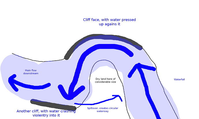
I have in some turbulent rapids seen this situation arise, creating an actual circular waterway, so it’s not a complete impossibility:

Will map next time!

4 Likes

Around here it seems to mainly be finding cases of a riverbank tagged as the river itself and occasional use of strange tags. Riverbanks being tagged as the river is a real problem, as the two are generally treated differently by most software that uses them.

I agree with excluding ditch and drain. Although some have obvious directionality, I’ve observed many where I can’t figure out the flow direction at time of survey or from imagery. I’m sure they technically have a flow direction, but if you can’t figure it out in the field on the day you’re there, it’s going to result in loops.

image

2 Likes

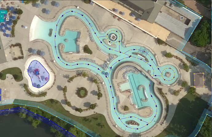
Found this water park attraction mapped as a looped stream: Way: 443088803 | OpenStreetMap

I’m guessing it’s a pool with artificial current, where people can float along in a loop. It’s not a documented tag, but there are 27 hits for attraction=lazy_river, which sounds about right.

3 Likes

You might want to exclude waterway=tidal_channel as well, since they’re bidirectional.

Edit: Also spotted a waterway=put_in at Way: ‪Beach/Kayak launch ramp‬ (‪355814424‬) | OpenStreetMap, undocumented but another good candidate for exclusion.

As the role of Spillways at the bottom of a dam is to regulate water release and some times avoid seismic reaction, let’s be reassured that water dont go up. look at usage=spillway | Tags | OpenStreetMap Taginfo or at the seismic type version James Bay Project - Wikipedia :rofl: :face_with_spiral_eyes:

As we discussed in a previous thread, the difficulty with canal derivations is to determine their flow characteristic.

  • they come back in the same watershed → they move down
  • they can be redirected to an other watershed → they move down
  • canals using the up tidal flow can move water up to saltponds

This is simply a temporary exception. I expect that globally more water is going down then going up otherwise their would be flooding aside the river. Floodings arise but are exceptional. This is why we see floodgates in places like Venetia and Rotterdam. :upside_down_face:

There’s a large loop near me that is caused by a way using this proposal for waterway=riverbed.

May need exclusion… may need to get the proposal refined. What do we think?

It also seems that the wiki documentation for waterway=rapids could use an update to indicate that it’s not the current preferred way to tag rapids as areas (natural=water + water=rapids?). I’m happy to make the adjustment but wanted to see if that’s incorrect/controversial.

it means canoe=put_in?

they can be flowing water, but also may be not flowing one

arguably a drain without flow is not draining, or could it?

Seems that’s a more popular tag. I’m not judging the validity of the tagging, though, just saying that a closed way tagged with waterway=put_in is a false positive for a looped waterway detector.

(If we were talking tagging, I’d say that using a vehicle type as a key is already pretty overloaded, encoding both vehicle-specific access and details of transit stops. Generally, vehicle keys aren’t used for “top-level” tags to map physical features. Not saying that waterway=put_in is better, but I understand why a mapper might prefer not to use canoe=put_in, tag popularity notwithstanding.)

Ran into another candidate for the exclusion list, waterway=derelict_canal. Again, possible to “fix” this by revising the tagging but it’s not IMO an error.

1 Like

About 2000 of these are from the CanVec waterway imports having water rapids areas marked as waterway=rapids + area=yes. The wiki suggests natural=water + water=rapids for such features and seems like a sensible and easy update. I’ll talk to the folks working on those things and see about doing a mass update.

Done those 2.

2 Likes

The rapids areas from CanVec have been updated to the modern tagging. :white_check_mark:

I have spoken to the couple of folks who have recently been doing CanVec imports and they should be in a spot now where more won’t make it into the DB.

1 Like

The few hundred cases of waterway=wash (from NHD imports) have been reviewed and modified to natural=wash. It’s an unusual feature unless you’re familiar with arid climates but is described pretty well here. The surface is pretty distinct from say natural=sand or natural=rock. Anyhow, they shouldn’t trouble the loop map any more.

In my area, water is rarely flowing throughout the year. Therefore, intermittent streams and rivers are often converted into canal/ditch/drain in order to regulate their flood flow near residential areas and roads. They are certainly part of the intermittent water flow network.