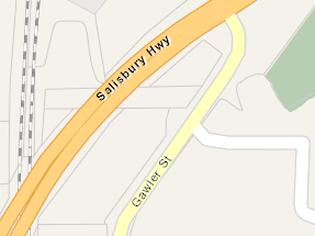
In South Australia, Over the last week a number of roads have been edited to change the classification from the actual usage of the road according to Data SA. The changesets Changeset: 146810025 | OpenStreetMap are left with a comment of “Change highway tags to reflect real usage”. I would like to point out Gawler Street, Salisbury.
Gawler Street never used to be a Secondary road barely could even class it as a territory road either!. Sailisbury Interchange is a major public transport hub cater to roughly 10,000 people per weekday and fluctuate depending on events in Adelaide city on weekends. October 2002 4 school kids were riding in a bus on their way home from school, the route the bus was taking turned right on to park terrace from salisbury highway. Due to congestion the bus became stopped over the railway line with nowhere to go. The Ghan which is a huge luxury passenger train was north bound heading towards the park terrace railway crossing. It couldn’t stop in time and crashed into the school bus. 4 kids lost their lives in that accident. it lead to a major overhaul of way the interchange operated. If you look at the bus route relations in OSM today you can see that no buses go over the railway line anymore… infact they don’t go through that section of park terrace at all. its not just buses its also trucks and long trailers. Gawler Street became the link to the primary network of salisbury highway. The city of salisbury built a memorial in the honour of the victims. Gawler Street needs to keep the secondary classification to divert traffic the intended and safest route to the primary road network. It is up to us to do whatever we can to prevent a disaster like this happening again.
The “real usage” is a secondary road, but more importantly secondary is the actual nature of the road. After my blocks winds up if a discussion here decides otherwise I intend to change this road back to secondary to reflect the actual usage of the road.
Thankyou