There has been a revival of an old discussion on the talk page of trail_visibility that has gone cold. It is proposed to remove references to marking quality so the tag only refers to visibility, but there are different opinions on how much to stick to the description by SAC (on which it is based) or to add additional description. Please contribute at https://wiki.openstreetmap.org/wiki/Talk:Key:trail_visibility#highly_confusing_tag so we can decide on what to do.
Er - not quite. The history suggests that you revived it, and a couple of people replied.
I’m not sure that that will help. Wiki talk pages are a very poor place to have a discussion. They’re entirely hidden to most OSMers and rapidly veer into the irrelevant (e.g. the references to GPS vs map and compass in the new section of the talk page).
Attempts to add caveats and more clarification to wiki pages tend to reduce their ability to convey meaning - right now https://wiki.openstreetmap.org/wiki/Key:trail_visibility is actually pretty good - it uses relatively few words, and gets the meaning across well. Where there are potential ambiguities (e.g. is the path unmarked but there are clear markers for some route along it?) it lets people use their common sense.
We lack a tag for route visibility (is it clear which path I should follow at a fork?), but to me, the Wiki page is pretty unambiguous about the fact that the trail_visibility tag is about path visibility: is it clear where I’m supposed to be walking to make sure that I’m still on the path?
That is, when the path is not visible on the ground (I am walking over grass or scree or snow), but cairns or splashes of paint on boulders clearly mark it, that still qualifies for good or excellent trail visibility. “Unambiguous path OR markers” implies that only one of the two are required.
Therefore I don’t think removing references to marking quality is a good idea: it would significantly redefine an existing tag. What problem would that solve?
Is this tag about whatever path itself is visible - or it is about whatever hiking route is visible?
Next marker always visible, but sometimes has to be searched for.
Indicates “about routes”.
This seems to be the source of the confusion. The way I see it, markers can be used for routes (e.g. signposts with route names on them) but they can also be used for paths. Of course, in some areas, there is only one path and that is the route, so the markers do both jobs. This is not actually a problem, because in that case, trail_visibility covers both, almost by accident.
A useful addition could be something like route_visibility. Consider a dense network of paths in a forest, all clearly visible on the ground, but no signposts anywhere to tell you which one to follow to make sure you’re still on hiking route ABC123.
I disagree that the tag is clear. The wiki defines the tag in terms of itself. I believe it should be the lack obstructions. An average trail will likely have some tall grass, a few low hang limbs or easily avoidable stones. A great one will be clear enough to run through. bout path clearance not visibility. The surface and smoothness tags can handle whether the ground conditions.
The other part of problem is that the current “visibility” values include aspects of how well a path is marked with signage. The two are different but related attributes of a trail. Signage has really nothing to do with be able to travel the trail itself. They become important when deciding which trail you should be on. The level of quality of marking should be a seperate tag with its own set of values.
That has never been how I have interpreted this tag. I have always assumed it means what it says, i.e. it is about how visible the trail is. How easy is it to know where the path goes and avoid straying off the path, navigating visually without referring to GPS or maps? It is true that obstacles may make the trail less visible, but I don’t see that as being fundamentally what the tag is about. E.g. sometimes I find that where a trail crosses a wide dry stream bed, it is hard to be sure where the trail is and find the right place to continue on the other side. To me that is poor visibility, even though there are no physical obstacles.
Again I don’t really agree. Taking my dry stream bed example again, if there is some kind of prominent marking every 10 metres, the visibility problem goes away as I can easily navigate visually. It doesn’t matter in that context if those markers belong to particular hiking route - I don’t even have to be aware of the route to use them for navigating that section of trail.
This has come up here before. From what I learned from peoples comments, it gets indeed mostly used to map how well the path itself can be seen on the ground, regardless of markings. Perhaps, as we now have Key:trailblazed - OpenStreetMap Wiki it might make sense to drop markings from this key.
SAC did not remove that, it was never in there, in their text. From point of view of navigation, of course it comes out much the same though. Gonna invite the originator:
PS: As to the routes: trail_visibility is not about, which way to follow at a crossing, it is about: Where is the goddamn path! And starting from bad, one might sometimes ask, on what ground is there mapped at path at all, if it cannot be seen so often?
Then removing the language about “marking” from it’s values.
I think we are talking at cross purposes here.
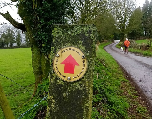
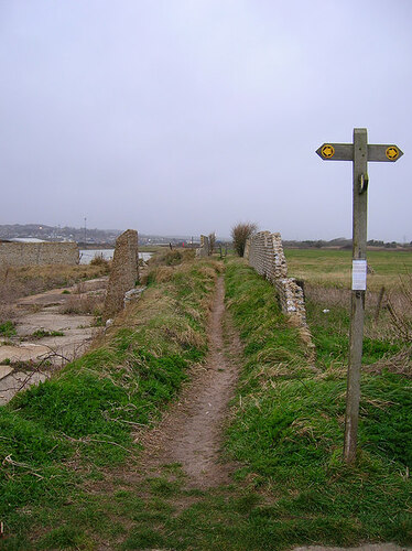
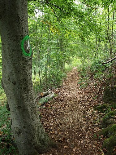
When the Wiki page for trail_visibility talks about markers, I don’t think of ones like these:
(Source 1, 2, 3)
These are markers that show you that a path is part of a signposted hiking route. The sort that is mapped in OSM as a route=hiking relation and that shows up on https://hiking.waymarkedtrails.org. They often have a specific symbol that is used just for that route.
The purpose of these markers is that they tell you which way to go at a fork. In the examples, whether or not such a marker or signpost is present is obviously irrelevant to the question where the path is, because the paths are very clearly visible on the ground itself. I wonder if the people who would like to see all references to markers removed from the Wiki page are thinking of examples like this?
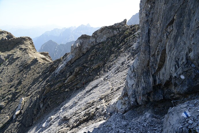
When I read the page, I think instead of markers like this (bottom right):
(Source)
This isn’t about which path to take at a fork. These markers are there to make sure you know where the path is in the first place. They are essential on scree, boulder fields, and anywhere else where the absence of grass or footprints doesn’t tell you where the path is. If you miss one, you’ll have to retrace your steps until you find the last one you passed.
They are everywhere in the Alps, but not so common in other places I’ve walked. In the UK cairns can play a similar role:
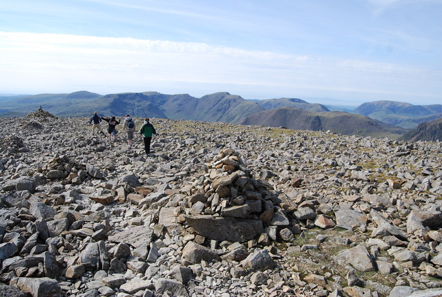
(Source)
So when the Wiki page says that trail_visibility is not about route visibility, and then it says that something qualifies for good trail visibility if you can see the path on the ground OR if the next marker is always visible, I don’t see a contradiction. The point is, you don’t really need orientation skills to see where the path is. (Though obviously if it’s in or near dangerous terrain you still shouldn’t attempt it, for reasons unrelated to trail visibility.)
It’s true that we also have the (much less widely used) key trailblazed for the quality of way marking. If we were designing a new tagging scheme from scratch, we could perhaps limit trail_visibility to “on the ground visibility” and use only trailblazed for marking quality. But we’re not, trail_visibility has been used over 600,000 times and the references to marking quality have been in the Wiki since the page was created. That’s why removing the references sounds to me like a major redefinition that would require re-surveying a lot of paths…
From what I gather from walking such paths, people consistently mapped trail_visibility NOT regarding markers.
PS: SwissTopo uses dots instead of dashes where there is no path, merely a route, this happily coincides with how trail_visibility is mapped in OSM, even on trailblazed SAC maintained routes. Just what I observed though.
Just to throw in a “how I might map such things” I would probably map a trail that would otherwise be “trail_visibility=bad” as “trail_visibility=intermediate” if there are cairns or other route markers on it - the east-west path here is an example of one that I added recently.
I guess, that @Peter_Elderson put it best here Proposal:Trailblazed=poles;cairns - OpenStreetMap Wiki
The tag trailblazed=yes is important because without it the way isn’t there.
Looking at the photo above, trail_visibility=no + trailblazed:visibility=excellent is just not the same as trail_visibility=excellent.
Speaking as the one, who probably tagged trailblazed=cairns first in OSM history, yet “had comments” during vote.
The one trailblazed=yes “path” I mapped has seasonal/intermittent visibility, when disregarding the coloured poles. It’s sand dunes with sparse to medium low vegetation, and the poles are mostly on the dune tops. Hikers tend to walk in the valleys between dunes. Though some like to show off and climb every dune to touch the poles, sometimes literally.
If there is snow or overgrowth, or a storm has wiped out all footprints in the sand, the first hiker to pass would say invisible, the second just follows the footsteps, and after that it’s a visible path until the next snowfall or stiff breeze.
I didn’t bother to tag trail visiblity at all.
I did bother to map the most likely trail from (or around) pole to pole, because several hiking routes use the “swerve area” as a section. Not much of a swerve though, if you get too far aside there is a fence. We’re not allowed to waymark the hiking routes in that area with their own route symbols, so we need the ‘trailblazed’ key to count it as a waymarked, hence mappable, route.
Not very helpful for the current discussion, I’m afraid. Sorry!
I don’t know about that, Peter. Maybe tangential, but certainly interesting, if not somewhat helpful!
I’m not sure I understand the point here. To me, trail_visibility=no trailblazed:visibility=excellent is just a contradiction. Even the proposal you link to calls trailblazing a “trail visibility improving feature”.
To be clear I certainly wouldn’t consider the path in the photo with the cairns to be trail_visibility=excellent either, but something near the middle of the scale.
There is definitely some judgement required which naturally means some variability in how people use it. Still better than no tag at all, or only yes/no.
I have not used trailblazed before, such paths are actually rare where I live.
I see! My point was just that I don’t find the Wiki page contradictory, and I wanted to make sure that we’re all on the same page about what kind of markers we’re talking about. I’m not sure how consistent actual mapping practice is with the wiki definition…
I agree with both - the trail_visibility=* to me means how unlikely I am to get lost while attempting to walk that trail. If I’ll reach home by following that trail in the middle of the night after 4 beers, I’ll call it trail_visibility=excellent ![]()
The exact method of how it might be visible can be done via many different ways: different surface (e.g. compacted vs dirt), by walls or fences on the side, by poles, via painted markings on trees (or rocks), via cairns, via posted signs, via solar lights embedded on the side of the path, or via millions of bones from skeletons scattered on minefields around safe path ![]() – the important thing is how (un)likely I am to loose the sight of that trail.
– the important thing is how (un)likely I am to loose the sight of that trail. ![]()
And which of the methods are being used to improve visibility of the trail might be indicated by trailblazed=*
In my reading of the Wiki Documentation, a path with markers will always get visibility excellent (markers everywhere) or good (next marker always visible, but sometimes has to be searched for). Only paths without markings can go intermediate or lower. Perhaps, that is why I did not tag visibility, when I added the trailblazing key near Kraspes. Trust me, from cairn to cairn, there is just rocks; Likely, because people just navigate from their personal assessment of the terrain. There are lots of such paths in the so-called nival zone, For the Sherlock Holmes around, they can search for lichen scrubbed, but they will not make miles then. I just cannot map trail_visibilty=good for that.
In the end, maybe the key should more explicitly say: It is about the ease or lack thereof in following the path as mapped in OSM. So to say, the navigational aids presented by not only human feet but also human hands.
I’ve been following this discussion without commenting so far, but now that everybody seems to have had their say, I think we can conclude that although the wiki description is clear for many, there are also quite a few for whom it is ambiguous. That means there is scope for improvement.
I suspect that part of the confusion is related to language. I’m not a native speaker of English myself (I’m Dutch), and realised that I misinterpreted 2 words: “trail” and “marker”. I always thought “trail” was a synonym of “path”, but after looking it up in several dictionaries, I now understand that its meaning is somewhere between “path” and “route”, so “trail visibility” is more than “path visibility”. By “marker” I understood “trail blaze”, while I now understand it’s “any visual clue” to where the trail is.
I think there are 2 possible approaches to clarification of the wiki text:
-
My original idea was that
trail_visibilityshould be separated into “path visibility” and “quality of marking (trailblazing)”. This would then have to be clearly described on the wiki page, with explanation that for “quality of marking”,trailblazed:visibilityshould be used. (I already added links totrailblazed:visibilityto thetrail_visibilitypage) -
We can clarify that
trail_visibilityis about how easy it is to follow the mapped way, and includes both the visibility of the path on the ground as well as availability of any visual clues as to where the trail is, including trail blazes, signposts, cairns, poles and other clues added for that purpose by humans as well as other signs of use such as the visibility of a treeless corridor through a forest (@IanH “lack obstructions”?), differences of vegetation on and next to the path, etc.
I now feel like option 2 is the best, if it is clearly explained, because it changes the meaning of the key as little as possible.
I think, you came to quite similar conclusions than I did in the post above. Two remarks though:
Not a native speaker here too, yet I got told from natives, that those terms are in fact synonyms and only due to American vs. British use. I cannot get rid of that though, that trail always rings route in my mind, something that path certainly does not do.
How do I tag path_visibility then?
I agree, to me (1) would be a redefinition and (2) merely a clarification.
On the linguistic confusion and American vs British English: This blog post is worth reading for anyone interested. Clearly, a lot of the things that we would call a route in OSM jargon are called “Something Something Trail”, which doesn’t help.
Not. If trail_visibility covers both path_visibility and trailblazed:visibility, I don’t see a reason (a use case) for also tagging them separately.
