This seems to be trying to address an issue I’ve alluded too a few times, but I did write it up for back-country ski routes (not marked, visible only in certain circumstances, often described in guidebooks).
I was pondering this last night and was thinking that a pathless route would almost work better as an area - it could be wide at the base, then narrowing at chokepoints and then widening back up again. I’m not sure how much value it has that point, but another approach to pathless routes is for people to draw very wide lines over a map.
We already have people adding non-paths as paths, which to me is less than ideal.
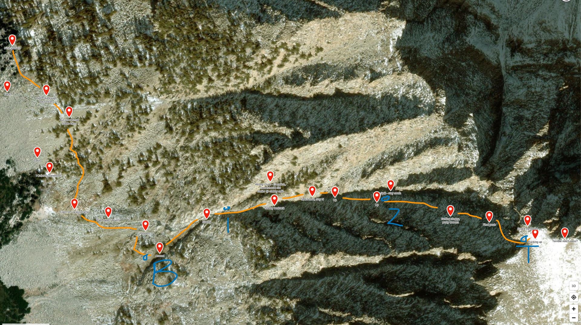
I’d also honestly be fine with just not allowing pathless routes - we already have some passes and cols which are not natural saddles, so are essentially the top node of a route that get away with being an arbitrary “feature”. I think for some of them having a bottom node would be good (Little Joe Pass can be hard to locate without GPS). My drawn up notes for a community elsewhere as an example (though I’d cut the vast majority of waypoints here, I’ve done two variations from the bottom and would consider getting to the base of the chute from Lake Reflection up to the person attempting the route with no nodes to guide them - I kept them in this photo for the context of how to find the proper avalanche chute to go up). Pardon the language at the top, it was quite a slog getting up there and I was tired lol. I marked in blue where I would have networked nodes for this route - four nodes, top, bottom, and the two main forks in the chute.
I’d say that in OSM terms a path can be a trail, and a trail can be a mix of imprint of human traffic on the earth and markers (where such imprints aren’t possible). A route can contain a path or trail, but may not. There’s also the distinction of routing or route relations, which is how to decide which path(s) to take to get to your desired destination.
So a route can have a path or be pathless (orienteering / routefinding), if there is a path it can take the form of trail or road or whatever.
Having a sequence would also be necessary to avoid ambiguity, sometimes one has to ascend or descend a certain area and traverse then go up again and it’d be hard to tell which horizontal marker to aim for. My screenshot here has a lot of extraneous points in it (things I found interesting, extra notes to myself, etc), I think in general there’d be 3-5 markers per side of a feature to minimally define a route, which shouldn’t be too hard of a burden to create.
We were about 80-90% sure it’d work out and definitely scouted it out visually and talked it over before trying it out and were willing to turn back and just head back via trail instead of creating a loop. No direct exposure despite the steep shadows.
I’m not familiar with them, it just came up as a suggestion that seems more sense to me than drawing a set path between nodes. I don’t think it should have the exact same rendering - I think having it follow more in the climbing route example where you have a top, bottom, and bolts in the middle makes more sense though I can’t think of any big wall climbs where they’d be easily visible on a map.
I do think that taking that idea to work off of makes more sense than modeling it after a road or trail as a distinct path. Having numbered nodes of a route (Cirque Pass Top, Cirque Pass 3, Cirque Pass 2, Cirque Pass 1, Cirque Pass bottom) etc with some descriptions on them or a short sentence if zoom the map in would make sense.
What lies between two cairns in a rocky area, according to OSM norms, would be a path unless the cairns are so far apart that it’s hard to see them. I’d personally view that more as a route (there is the ability to routefind your own way to the next cairn, vs following on top of bootprints on a surface) but since there are many formally maintained and recognized trails that consist of regular markers over terrain that won’t hold imprints/wear on a surface I think just saying that there is a path there is fine. If there’s a marker every 10m or 30ft in open areas I think that’s “pathy” enough, vs say a cairn every quarter kilometer or cairns that random people put up on their own versions of a route in terrain that has no formalized path on it.
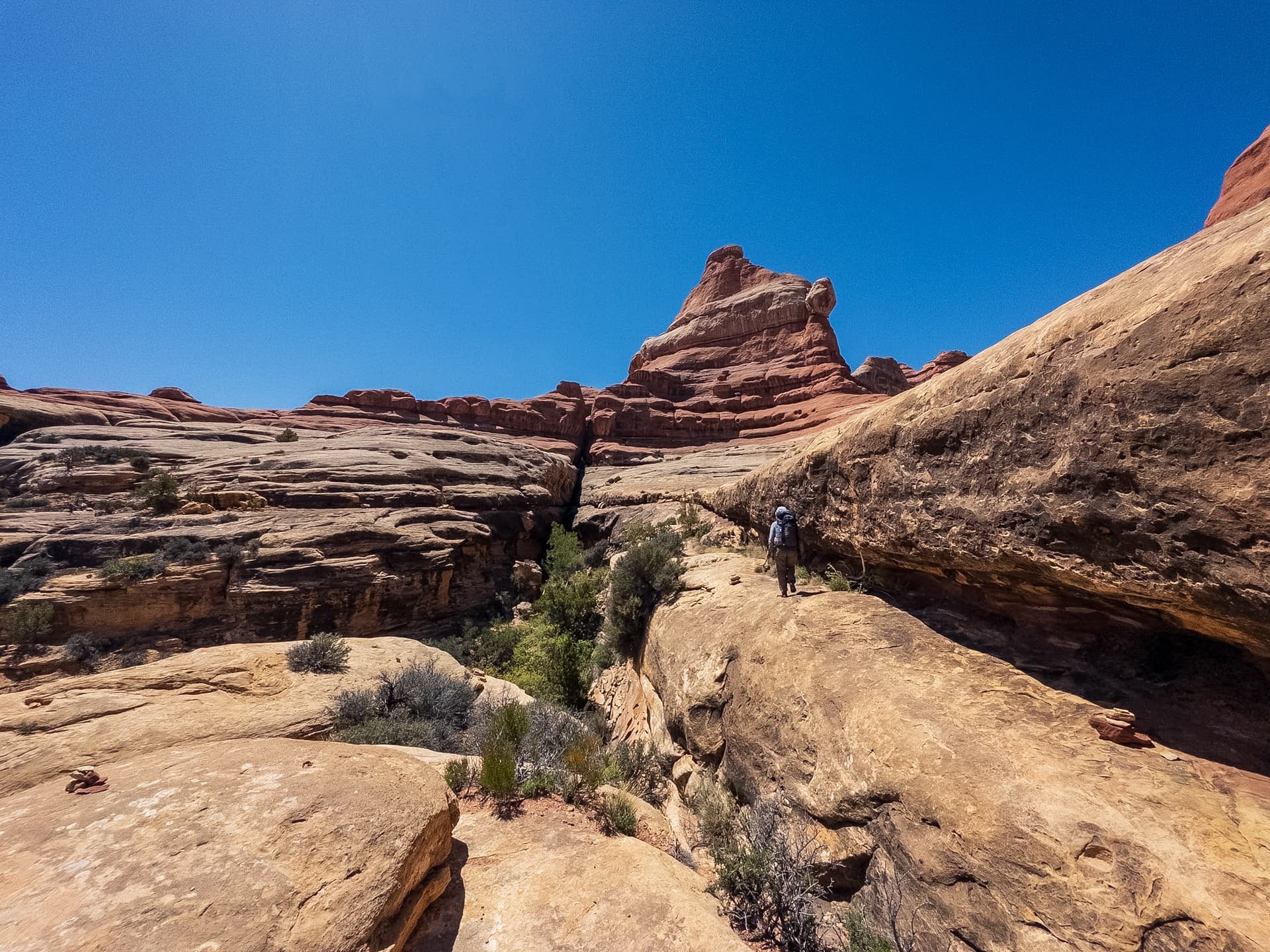
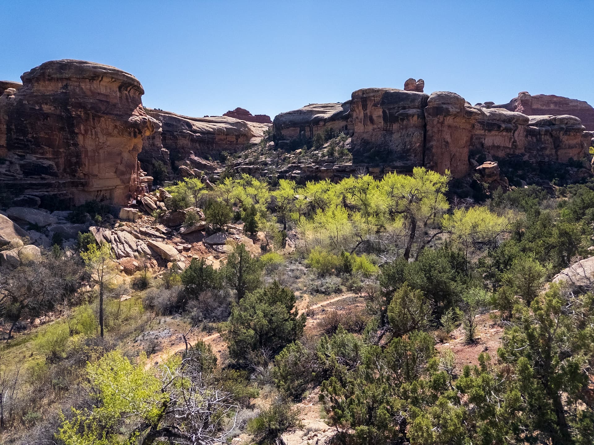
The “Lost Canyon” trail in the Needles district of Canyonlands National Park is a nice single track dirt trail when it is in valley floors, then switches to being markers only (cairns) for going over a ridge, then switches back to single track again. If the conservative (in terms of not wanting tourists to die and have to medivac them out) national park service calls it a trail who am I to argue?
And looking down at the same “trail” earlier that day where it is clearly visible single track.
If there’s just a cairn here or there it’d be trail_visibility=horrible and/or trailblazed:visbiilty=horrible trailblazed=cairn. At the point where we have a trail_visibility=no which is entirely or mostly pathless (or IMO a route which is bad or horrible visibility with only markers and no path) I feel like it should just be rendered as a route, or as fragments of a path where there is a use trail with blank spots in between for people to figure out for themselves. There’s a lot of broken “fragments” of paths in the Sierra Nevada mountains which seems appropriate to me in terms of ground truth.
That link isn’t working for me. ![]()
Works for me both in the quote & original post. Wonder what the issue is.
Ah, it blocks my VPN. Loaded it now.
Routes. To a certain extent showing routes spoils some of the key aspects of being away from the piste. Picking ones own line, both in the light of one’s ability and safety of surroundings is part and parcel of developing the skills and awareness necessary. In many places (Albona at Stuben, most of Les Grands Montets below 2800m, Pavi in A-basin) all that is needed is to show that the area is free-ride territory. In others entry lines and exit routes may not be immediately obvious and are worth showing (it is not uncommon for these to be the least pleasant part of a route), particularly if there are cliffs or other hazards lower down (e.g., above Le Fornet, Val d’Isere).
Very similar thoughts here. Hazards seem to be more snow orientated - trying to map every area with loose talus or exposure doesn’t seem feasible, and there’s less surprise due to going at a slower pace and not (generally) having terrain buried under a potentially thin layer of snow.
For your purpose, having a general area with optional entry/exit lines seems to make sense, and that’s something I considered in my comment above (though more a node for top/bottom than lines/ways). It’d be a bit noisy for a general map, but could work if rendered as a separate map layer by clients that would be opt-in.
“Trail” has a distinct meaning in American English (and to some extent Australian/NZ English) which is closer to “Route”. It is not often used that way in British English. I would therefore generally advise against using it in OSM to avoid confusion. I realise this is a bit of a horse-bolted[1] scenario in a thread about trail_visibility but there you go.
[1] es ist ein roß entsprungen, as the hymnodist wrote.
1 Like
To a certain extent, though that’s regional. I always thought of trails as the compacted/scarred surface over terrain growing up in California, after spending more time in the southwest where trails can consist just of cairns for periods of time I’ve had that narrow definition expanded but still think of a trail as a nice single track in my head vs a route. The NE has a lot of tree blazes, Acadia has cairns, etc.
There have been some calls for the new trail_visibility to have an alias path_visibility that would be used going forward with trail_visibility being deprecated and eventually ported over, but it hasn’t caught on. IMO that’s a bit clearer if it encompasses both surface and markers. You can chime in at Tag trail_visibility: Proposed Improvements for this Descriptive Tag where this thread/issue was forked from to help keep it on topic.
1 Like
I like the diplomatic answer, in OSM a trail can be a path or it can be a route ![]() (Thereby ignoring the where clause. But who is going to honour that?)
(Thereby ignoring the where clause. But who is going to honour that?)
In my area, trails where on the ground there is not much bootprints, but where there is a steel cable running all along (not of the via_ferrata kind, but the assisted_**trail** kind), get tagged trail_visibility=horrible. If trail_visibility is to start meaning any clues, we have to change some mappings, some dating back ten years.
The name of the song, the Christmas carol, is “Es ist ein Ros’ entsprungen” - a rose, not a horse ![]() It is a very nice song, I never managed to sing it correctly.
It is a very nice song, I never managed to sing it correctly.
I’d just appreciate if debate here kept to one meaning, so I do not have to guess every mention of the term. At least path seems unambiguous?
A bit of digging found this, birth of the idea for the sac_scale tag - Re: [Talk-de] Wanderwege, Klettersteige, Kletterfelsen
Here Re: [Talk-de] Wanderwege, Klettersteige, Kletterfelsen it was voiced, that a new base tag highway = trail might make sense, and one highway = via_ferrata just as well. But this immediately got voted down, to not create more highway-inflation, and use highway=footway instead. Discussion then turned on to cycleways.
So, that should explain, why its called trail_visibility and not path visibility, because the brand new path only came little later, but just in time to make it the preferred base.
.
1 Like
maybe I’m becoming too conceptual here but could we say that, in the universe of routes (people advising other people where to walk), a path is a special case of route? That is, it has its own way of conveying information whereas other routes rely for that on cairns, on signs, on lists of pre-existing routes, etc.
This would open a way to situations where a route can be made of routes that are either paths, composite routes themselves made of other routes… and other objects (non-paths) made for instance of ordered lists of nodes ?
I have been looking for some suitable examples and this precisely relates to one I have found.
The Westgrat of the Muttler is mapped as a path on OSM, but is not marked at all on the SwissTopo maps. There are some good pictures in this account on Hikr showing that as the rock band is reached there is a cable anchored to the rock, implying some existence of a route
I’ll add some more to the thread later, for instance Fluela Wisshorn (GR, CH), Piz Minschun (GR, CH) and the Bliistock (GL, CH)
It’s a famous mispronunciation by non-German speaking choristers!
(Though the finest version is of course the one set to the English translation ‘A Spotless Rose’: https://www.youtube.com/watch?v=QQnApR9PNV8)
I’ve mulled over the idea and come up with a simpler version (and a more elaborate one, but let’s keep it simple)
What if what we need is routes that can be routable even though they contain elements that are not ways? It would be the responsibility of apps to decide how to render series of cairns, areas, etc.
Thinking about the data model, there are nodes, ways (= ordered sequences of nodes), and relations (= ordered sequences of nodes, ways, and relations).
For routefinding in the wilderness, @erutan would like a way to describe a route as a series of way points without having to draw a highway=path between them. I can relate to that. A lot of hillwalking routes in Scotland are variations of the form “park your car at spot X, walk to the saddle, then follow the ridge to the summit and back down again”. To draw a highway=path here, with trail_visibility=no trailblazed=no, would essentially be troll tagging. If people in the US have been doing that, it’s natural that we should look for a solution.
Now, it seems to me that there are two questions here. The first is, how can this be represented in OSM? We would need new tags for the nodes, to say that they are waypoints. @erutan has made some suggestions. For simple routes, an ordered list of nodes can be represented using a way whose elements are the way points. You don’t need a relation at all. In fact, the typical route=hiking relation is a sequence of highway=path objects (or similar), and that is exactly what we don’t want. The question is just, what would be an appropriate tag for such a way? pathless-hiking=route? And when the situation is more complex, because there are alternative way points, what would a suitable relation look like to hold this data? Should this be modelled after how climbing routes are mapped, or after how node networks are mapped, or some combination of both?
The other question is, should this data be in the OSM database at all? Are such routes verifiable? Besides, you can already map summits, saddles, cairns, and (for better or worse) arbitrary named locations, so how much would it add to group them in a relation? I think many of these questions need to be answered by more experienced mappers than me… but it seems to me like these are the questions we need to be thinking about?
If a tagging scheme can be agreed, we would then need to lobby existing data consumers to support it, or new maps and apps would need to be developed.
The ‘alpine routes’ that have been discussed here are a little bit different, aren’t they? When there is an obvious route between two way points, because you follow an arête or a steel cable or way markers (trail blazes) placed every few metres, there is a verifiable geometry that can already be mapped as a way using established tags. So if these should come under the same tagging scheme, then we would need relations that sometimes consist just of nodes and sometimes consist of nodes and the ways between them.
Exactly what I was thinking! I understand that what @erutan calls a node network is like a series of ordered “virtual cairns” that suggests a route where there is no visible path (or markers). I think it is a good idea by itself, but in the spirit of https://en.wikipedia.org/wiki/Wikipedia:No_original_research, it should be developed outside OSM. Once such a system of virtual cairns is established and made official (by a National Park authority, the American XC Association (if it exists), etc.), we can quote them by adding these virtual cairns to the map. Adding them to the map without some form of official endorsement, they would be like
In my early days as a mapper, I did add paths to the map in mountainous areas based on GPS tracks I found on Internet, not even knowing if they represented visible paths or not. My motivation was to help other hikers and myself by showing that “this is a safe way to cross that pass” and to be able to get an idea of distance and time needed to hike that path (using a routing app). What I should have done it to upload those GPS tracks on my own phone, and upload my own GPS tracks to wikiloc to show people where it’s safe to go.
What we can do, of course, is to add information to the map to show hikers where it’s not safe to go, such as cliffs and screes, as long as they exist on the ground.
(off topic) On the topic of not promoting the creation of more informal paths, the European approach (by National Parks and the likes) is often to provide (marked) paths on purpose while at the same time forbidding hiking outside those paths. In stead of spreading the bootprints as much as possible like the American XC community tries, the Europeans generally try to concentrate them on a limited number of paths so that the rest of the area stays undisturbed.
1 Like
are you deliberately leaving areas out? sorry to be trivial, but we already have to deal with pedestrian areas in routes.
1 Like
That’s an argument for this thread Tag trail_visibility: Proposed Improvements for this Descriptive Tag - #87 by erutan. I’d personally consider a steel cable as designating a path, similar to a line of rocks.
I think that makes sense, and that a “path” is a special kind of route which has to have trail_visibility. (linked to above, currently a matter of some controversy). The Sierra High Route is 200+ mile route that is a mix of official trail (paths), social/informal trails (not maintained, which have visible wear to follow), and off-trail routes.
I think having a top and bottom node would allow for “routing” connecting it to paths in a mapping application. That would then require that said nodes connect to a path, which isn’t always the case. In the Little Joe Pass example above with four nodes, the top of the pass opens into a SAC 1-2 open area which one can then routefind to the nearest trail as they see fit. There’s a few options but they are all a few miles away and creating an arbitrary route just to allow for that case doesn’t seem appropriate to me.
OpenStreetMap there was an existing path here that I deleted from OSM because a) it had no ground truth b) it made some poor routefinding decisions leading from lake reflection to the base of the pass.
I’m pretty sure the nearby Millie’s foot pass doesn’t have any ground truth, but haven’t verified that.
Harrison Pass follows an old trail that hasn’t been maintained for 90 years, but a path probably exists in some fashion except for the steep northern part of the pass where there’s been enough collapsing terrain that it’s gone.
These are sort of “power user” type things and I’m not sure someone that wants to find the fastest way from A to B should have off trail routes included in that by default.
We’re definitely on the same page here! ![]()
As to “alpine routes” I’m not familiar with the ones in Europe, in the US they are generally informal and don’t have Via Feratta, though climbing_routes will often have bolts on them which may or may not be officially sanctioned. Any markers are informal user made cairns, which may or may be helpful (some people cairn bad routes - I generally ignore them unless they’re marking the top or bottom or something to be honest).
I would say if there’s markers every few meters that would fall into a path… there’s technically some routefinding to be made between each marker but that’s within the margin of error of GPS for someone checking the path on their phone or other digital mapping device and there’s no real experience needed in routefinding or orienteering as you can presumably find the next marker easily, that’d fall under trailblazed:visibility=good or trailblazed:visibility=excellent.
I honestly wouldn’t mind a policy that just bans pathless routes, but there’s an appetite for them and having something like a relation of nodes to me seems like a possible compromise.
In the Sierra Nevada a lot of these pathless routes are marked by a saddle feature, which is not actually a saddle feature (see little joe’s pass above). This indicates that a pass is there, but doesn’t say anything about the safety or ease of reaching it (some are simple, some are deadly). If we can have the top, why not the bottom (which in some cases is just as important), if we can have the bottom, why not a few points in between… it’s a bit of a slippery slope argument, but one that I think needs to be addressed. ![]()
I’m not sure about marking out scree/talus fields that are unsafe - a lot of times that comes down to individual experience and skill. I’ve “boot-skied” down collapsing scree and found it fun, while my partner shook her head and just potholed down a steep snowfield (that I didn’t feel comfortable on). Some named off-trail passes & cols include unstable talus, others are simple walks, and others require some simple climbing. Cliffs should already show up via the new high resolution slope angle shading, at least in most of the US ala Latest High Resolution Elevation Data Updates - CalTopo
Some areas of the US ban off trail travel, or do so in specific fragile areas. I think a major factor is we just have a lot more wilderness that hasn’t been impacted for as long - I do enjoy how entire basins are left pathless instead of building trails up to them and I do my best to destroy any cairns I see in them. ![]()
I’m not sure about how to mark that (having an area that overlays terrain would be noisy) but it’s something to considered even if there is “ground truth” for an informal path. There are some tags for paths that are not recommended by land managers if I recall.
1 Like
I’ve personally added some informally named XC passes (that are known in the local mountaineering community, sometimes mentioned in guidebooks, etc) as I think they provide useful information, but would not add nodes in the middle except in relatively rare cases where there is genuine routefinding confusion or people often make routefinding mistakes (and have not). There’s only one or two cases where I’ve been tempted to add a bottom node. I think in terms off of trail passes the majority are fine just having a top marker. When writing up passes I generally push back on people that think their way of doing a pass is the way to do it, or the optimal way, as everyone has their own comfort levels and terrain preferences, though at times there is an obviously safer or simpler route.
One issue I can see if how to enforce the subjective bright line of keeping the nodes sparse enough to feel like a route. Someone can just put a node every meter etc if they want to, which would defeat the purpose (or create their own cairns and map them). On a related note, if trail_visibility changes to include both the surface and markers, someone can just stack a handful of cairns for a route and just tag it as trail_visibility=no and that would technically be a valid path, as it is mostly pathless but includes some markers. ![]()
The ones, the Alpine Club marks with respective sign on their guideposts certainly are different. I am fine with them mapped as paths. Not so though with the routes from the guidebooks, comparable to the Swiss High Alpine Routes (where the Mountain Hiking Routes, that are covered by its SAC Mountain Hiking scale are the approach routes.)
Cliffs are fine to see, not all users have excellent DTM; screes get mapped already, they rarely are dangerous, often fun instead, going down.
I agree, a perfect example why a path with trail_visibility=no can still be mapped a path, without breaking the verifiability credo. Mind you, these cables are no suitable to plug carabiners, just something to hold on. Sometimes they are more a nuisance, if having to step over them to not fall, when they lie on the ground. But some people cannot get enough of them.
One more reason to map an invisible path, where there is no path to be seen OTG, while still being verifiable as used for human traffic.
I heard, asking locals about a name makes it verifiable, cant this apply to routes ![]()
Routes can contain paths, that is what we have now. Lots of routes get by with that. Routes can also only mentions waypoints where no path leads to. The goal is to map those, and not pull paths out of the thin air, to meet the current model. Please continue your research!