The author of the proposal seems to consider the tag though not specific to hydropower but instead to apply anywhere water is contained without space left for air, such as naturally occurring siphons.
From participating in this issue there, I got the impression, that this indecisive meaning has actually been approved back then. Therefore this RfC: As can be seen from the waterwaymap issue, this creates more problems that it solves.
To questions to quick start discussion:
Does anybody know of natural features, like siphons on rivers or streams – perhaps even in lakes or the sea – actually having been tagged waterway=pressurised? How is it then recorded, if that section is a stream or a river, or a flow in a lake or the sea?
Wouldn’t it be just so much more straighforward to apply siphon=yes to a stream or a river and not having the problems of how to tell, what kind of waterway something is?
To be more precise about my point of view, I currently only use waterway=pressurised on artificial features (not only hydropower) as it was approved back in 2017.
However, despite it was argued that “pressurised” sounds more artificial than natural, we are still lacking a valid solution for natural inverted siphons as @yvecai mentioned.
The original intention to split water flows from their containers (pipelines, tunnels, caves, whatever) is valuable to efficiently take care of a large diversity of situations seen on ground.
It’s consistent to classify water flows according to their regime and their containers by their artificial or natural character.
Even if we agree on not using waterway=pressurised for natural sections, handling pressurised sections (both artificial and natural) is required to process watersheds connectivity graph.
A river going through a dam will be tagged as man_made=pipeline + waterway=pressurised and this section will be involved in the river’s relation.
Rivers and streams are free flow and are opposite from pressurised waterways.
It would be ok to define waterway=siphon or something similar.
Let’s remind some simple points :
Hydropower is not the only artificial water usage and there is no point to specialise waterway=* values for hydropower (however some had been proposed to address hydropower water supplies)
Artificial and natural are more related to the waterway’s course/container than the waterway itself
In my opinion, a river going underground is still a river. If openstreetmap wants to have an extra term for that, it should be amenable to lay persons so it gets consistently mapped.
Siphon not bad. Anybody knowing of such where natural and big enough to actually map? Other than hazard=siphon as a node for white-water enthusiasts?
The feature @yvecai mentioned perhaps a waterway=aquifer then? It has been proven with die, so fulfils the OTG truth requirement, not for the exact course, but at least the end points.
I’m not sure but it’s probably percolate flow, so different from free or pipe flow.
An aquifer is yet another feature than siphons or underground rivers.
To me, “pressurised” implies that it is at a higher pressure than its surroundings. I would tend to think of things that run underground naturally as being at (approximately) the same pressure as their surroundings.
Essentially I think of it as being gauge pressure rather than absolute.
If something is naturally full bore flow then I’d rather we had some sort of flow regime tag that indicated this directly rather than assuming things about pressure which does all sorts of counter-intuitive things as flow encounters changes in section and bends.
Similarly for a culvert or underground pipe or tunnel that we somehow know about, I wouldn’t want to record guesswork about the pressure of the tunnel/pipe relative to groundwater.
I would prefer if (naturally) underground rivers and streams just get tagged as rivers or streams with a tag to show that they are underground or in a cave and tagging to indicate if they are fully flooded or not (if known). If we think that is too much of a step change from current tagging and would whip the rug out from under too many data consumers then maybe waterway=cave/underground+full_bore=yes/no/intermittent?
The static pressure (at the intake) depends directly of the height between the intake and the water surface. It can be visually confirmed by anyone, it’s not a guess.
If a cave entrance is below the level of a lake, then the flooded section of the cave below this water level is pressurised, whatever the surroundings can be.
Just like a tunnel, if built by human.
It’s not legit to transpose the environmental difference between a cave and a tunnel to the contained water inside. It’s the same water with same (rather similar) physics.
I prefer to keep common waterway tags in these cases (river/canal/stream etc) with either a tunnel=culvert or tunnel=flooded tag, depending on the situation, both of which are already well-documented. See for example Way: Linge (973099226) | OpenStreetMap, which could arguably have tunnel=flooded.
In any case I support the idea of limiting the usage of waterway=pressurised.
If the inlet’s actually limiting the flow then the actual pressure inside the tunnel/cave/whatever can be lower than this, so yes, you are still guessing. This video has some nice visuals. In the case of a tube siphoning out a bucket (or emptying a pond over a dam) it can even dip below atmospheric at which point pressurised is a very, very silly tag despite the pressure on the inlet itself.
By this logic we should be tagging the middle of a lake as pressurised, and coral reefs, and the bottoms of deep rivers and the inner edges of dams. For what that’s worth an air filled tunnel is pressurised by the weight of the atmosphere so they should be pressurised too. There is no logic to treating hydro-static pressure differently here than we do anywhere else.
This is why I say it only really make sense to me for this to be gauge pressure, relative to the surroundings and the only cases where this is going to be obvious to mappers is when they’re clearly full pipes surrounded by air. For everything else we’re better off mapping what can be unambiguously determined and that isn’t (usually) pressure.
From my limited command of French, this is about lakes?
That would put aside waterway=siphon, I’d be all for that. Some hydropower installations superficially resemble siphons, but they get mapped tunnel=flooded. Current practice well working.
Prime example the Venturi pipe. Nice video, BTW. Sections with left-handed-driving?
Siphon is a bit too precise a term IMO. That’s why I suggested waterway = subterranean in the other thread, as most than often a proper survey wasn’t ever done, one just now water flows from there to here underground.
Think of karstic ground, for instance : there can be siphon, rivers, lakes…
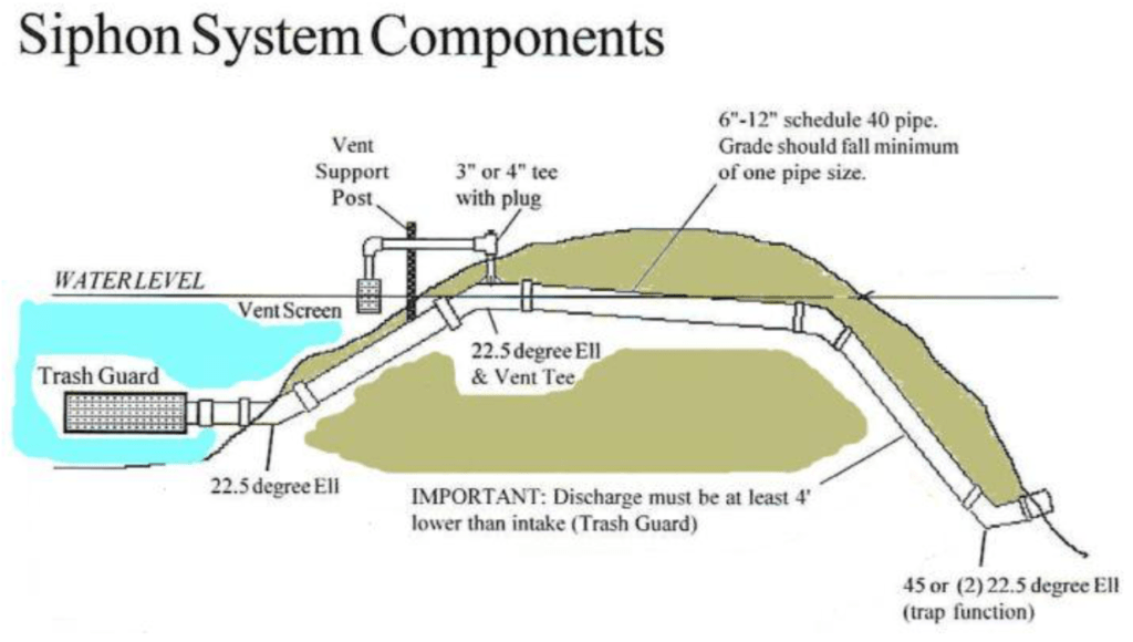
waterway=pressurised is well defined as The waterway=pressurised key maps artificial conduits where water flows in a permanently closed space, without air. As water is filling all space available, it applies a positive static pressure on the conduit walls.
Hopefully bottom of a lake is out the scope of our discussion and actual siphon is the only exception to this definition.
No, the page states the opposite, it doesn’t cover the lakes.
See also: Sump (cave) - Wikipedia
This value would be too generic as it not properly distinguish pipe flow regime from percolated regime.
This is a value, not the definition of it.
In my mind the definition would be ‘natural water flow of uncertain geological type’.
A subtype or other values (underground_river,…) could be defined when there is more clues.
I read that: They do not cover any old lakes, just the ones of interest for speleology. Many of their samples are just holes in the ground. No water flowing there.
Some are springs, Schwarzbachfall-Höhle – Wikipedia - from the drawing one could map an underground waterway there. Openstreetmap ontology is missing a tag for this.
Waterway=pressurised should be limited to artificial structures. Obviously, the mapping community does not use it outside of that? So after all, nothing to deprecate?
Like anything in OSM, if you can’t map it, then don’t map it.
Some situations are well documented by speleologists, sometimes described in sources suitable to use in OSM. It’s easy to get if it’s a siphon, inverted siphon or gravitational flow without guess and we can provide elevations on most representative nodes in OSM to testify it.
Some other situations are undefined, require to investigate more if possible but are they representative enough to refarm OSM tagging?
Yes, but we struggle to find anything better.
The original RFC upside states it should be deprecated for anything except hydropower. First point to make is to include many many more situations in artificial category. No point to restrict anything to hydropower here.
I think we’re having translation issues here. What is your definition of “free flow”? Flow with a free surface, or flowing without restriction? If “the same environment” is a theoretical borehole nearby that has equalised with the groundwater then I think many of the “siphons” are probably going to be the same or lower pressure.
That’s why I’d go a bit further than the RFC and depreciate waterway=pressurised almost entirely for underground stuff, especially if it’s natural, and probably some overground stuff too. Whether it is siphon=yes or some other tag, I think that’s a better way to go about the tagging. We can then tag whether it is pipe flow (or full bore or some other synonym) if we have access to that information without having to do more involved analysis.