According to Wikipedia, there is an underground connection (OSM) between the river “Esera” and the spring “Uelhs deth Joeu”. The water from the Esera seeps away at the “Forau d’Aigualluts” and then emerges again around 3.6 kilometres further on. The Wikipedia article can be easily read using translation tools and is very interesting.
This phenomenon connects the Garonne and Ebro rivers and creates a link between the Atlantic and the Mediterranean.
Is the used waterway=stream the correct tagging for this natural phenomenon?
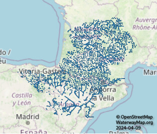
The connected watershed can be seen on WaterwayMap.org, on the “Natural Waterway (excl. canals)” map view, which is aimed to be “naturally flowing waterways”. (wwm.org intro post)
The current tag filter for calculating this is: waterway∈dam,weir,lock_gate,sluice_gate,security_lock,fairway,dock,boatyard,fuel,riverbank,pond,check_dam,turning_point,water_point,safe_water→F; waterway∈ditch,drain,tidal_channel→F; waterway=canal∧lock∈yes,disused→T; waterway=spillway∧area=yes→F; waterway=canal∧usage=spillway→T; waterway=canal∧usage∈headrace,tailrace→T; waterway=canal→F; waterway→T; F using the osm-lump-ways tag filtering system¹
It’s the waterway=stream tag on w413263368 which causes these 2 watersheds to be joined.
Initially I thought it was a mapping mistake, but now I think it’s a regular river bifurcation. Changing this from waterway=stream to something else might be a good idea. But I think any map of “connected natural water flows” will have to include join the Garonne & Ebro like this.
¹ Yes this is a new tag filtering system. No, I don’t want to implemented SQL
So, how about a new tag describing natural subterranean water course or flowing aquifers?
Practically the exact course is often unknown, however waterway connection is known from experience or geology.