For that we need to have a good understanding of how the tag is used right now, based on actual usage and not just the documentation. Once we know that we can come up with alternatives for specific and common use cases.
A more correct term would be open channel flow, flow with a free surface.
It’s really unclear to me.
Which underground and overground pipe flow stuff shouldn’t get waterway=pressurised?
A penstock (as you are referring to artificial infrastructure as well), whatever underground or overground, whatever its usage can be (hydropower, irrigation, sewerage…) is pressurised every time, aren’t you?
Are you proposing siphon=yes for actual siphons or inverted ones?
I started this topic under the assumption that waterway=pressurized was used or even approved for anything not having to do with hydropower, the topic of the proposal it came with. I started this Request for Comment by the community after a long discussion on the waterway.map issue tracker, where @InfosReseaux stipulated, that waterway=pressurized was a fine tag to map natural underground waterways, e.g. inverted siphons.
As already mentioned above: As far as I can tell, nobody uses the tag for that and nobody considers this use approved in any way. I consider the tag fine in hydropower installations. After all it just echoes the engineering language used in the field.
I think I already asked but got no response, perhaps even in top post: What are the actual uses of waterway=pressurized apart from hydropower? Links, Pictures, Diagrams?
It’s possible that waterway=pressurized implies man_made=pipeline and substance=water, but there are some counter examples per this Overpass query.
One of the more common counter examples seems to be tunnel=flooded, which according to the wiki is “A flooded tunnel is an artificial structure intended to channel water on a significant distance.” The wiki says this is different from man_made=pipeline, but I’m not sure I understand why.
There are also some instances of waterway=pressurized with pipeline=penstock but without man_made=pipeline. This seems to be a mistake to me, but maybe I’m missing something.
Just about any closed pipe full of liquid is pressurised, if only by the mass of the liquid inside. Elevation change and pumping influence flow and pressure. Storage elevation provides pressure. Pipe friction reduces pressure. There are 1000s of kilometers of underground pressurised pipes in the UK alone. Only a small percentage relate to hydropower. Thanfully no-one has attempted to map them all on OSM.
Perhaps it is better to tag pipes related to hydropower to purpose=hydropower or similar. This removes uncertainty from inferences and also allows for purpose=* for gas, water supply, oil, sewage etc. Each of which operate under pressure and can be hazardous as a result.
1 Like
Here are the different usages combined with waterway=pressurised.
- Only
headrace,penstock,tailraceand sometimesspillwayrelate to hydropower, so 36% of 8 300 km currently mapped. - 2 250 km relate to transmission and irrigation, so 27%
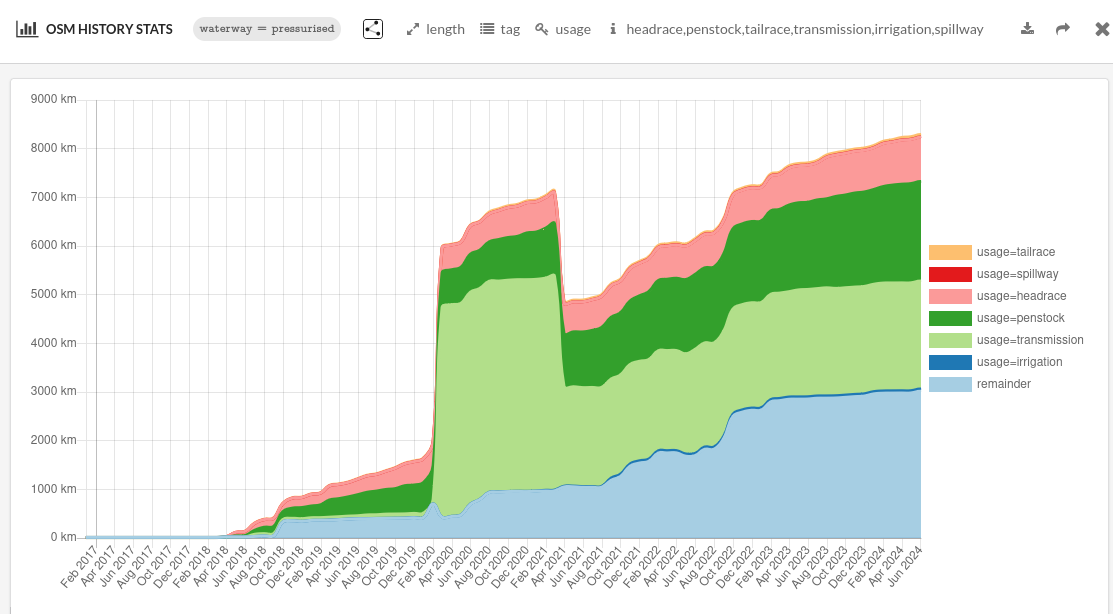
It’s wider than hydropower only and 3 015 km of unspecified or other usages may relate to more different things as well.
No, as it was proposed in combination with tunnel=flooded from the very beginning. It’s not a counter example, it’s done on purpose.
Because a tunnel is bored and a pipeline is a assembly of pipes. It’s a different structure for different purposes.
Yes, it should be waterway=pressurised + man_made=pipeline + substance=water + usage=penstock.
We already got usage, utility and substance for that.
Hydropower infrastructures, including the whole millrace, should be involved in a power=plant + plant:source=hydro relation like this one.
1 Like
Thank you re the usage, utility etc tags. I’m an OSM tagging newbie, so huge amount to learn. Given they exist, I can’t think of a good reason to limit waterway=pressurised to just one utilty.
(I’m not a water utlity data newbie, and I have some concerns about some sewer/drainage mapping that I should put down in words.)
1 Like
That was the proposal in the original post of this thread, mine was to use full_bore=yes/no/intermittent to record record whether it is pipe flow or open channel flow (if known) and sidestep the pressurised thing.
Penstocks would probably be one of the few cases where you definitely know that they are pressurised as that’s their whole reason to exist: they lead in to a restriction (turbine).
That’s just one use or definition of a penstock. They existed well before modern hydropower and may themselves be open to atmosphere. The term may also be applied to an associated control valve, usually a gate type. Sloppy terminology perhaps, but that’s life.
1 Like
Semantically, the only way to sidestep waterway=pressurised is to propose a new waterway value.
Usage chart upside shows that there are way more features than penstock which are pipe flow.
Water mains, artificial inverted siphons, irrigation abductions…
Pipe flow may not only be a feature but a consequence of infrastructure dimensions and flow rate to carry as well.
(creator of wwm here ![]() )
)
To clarify, “natural” vs “artificial”, I don’t care if a person dug a canal/pipe for the water, or not. I care if the water inside it is being pushed against gravity. I thought =pressurised meant “this water is being pushed uphill” (hence I removed it). WWM looks at waterways that are flowing under normal gravity. I don’t know enough about hydrology to comment more, I merely ask that yous tell me which tag(s) i can look at to only get naturally flowing water.
3 Likes
=pipe, =cavern, =subterranean_river or even =penstock =raceway. For many of them we could just let the river/stream tag stand.
The inverted siphons would be vacuum rather than pressurised though?
I’m getting no sensible Google results for “irrigation abduction” do you have a link to the untranslated term so I can see it in context?
I thought an open one was usually a race/raceway or a flume?
I’d say theres no 100% constency of use across industry and cultures. You are mostly right about general use, but alternative useage exists. Don’t get me started on valves! Perhaps mappers should not get too involved with terminology precision that’s not followed by any paticular domain?
(Apologies for lack of quoting, not worked out how i do it on phone.)
1 Like
I’ve been following this thread, wondering if the existing OSM tagging is appropriate and sufficient to describe two local features:
The Colorado River Aqueduct, which has two reservoirs, five pumping stations, 62 mi (100 km) of canals, 92 mi (148 km) of tunnels, and 84 mi (135 km) of buried conduit and siphons. (Edit: The diagram on the Wikipedia page is worth looking at.)
The Mojave River, which runs naturally underground for the majority of its length. However, the course of the river is generally constrained by less permeable bedrock.
Thanks to the explanations by @InfosReseaux, I’m pretty well convinced that the existing OSM tags would work for the aqueduct, where waterway=pressurized would certainly fit with the pipelines heading up the mountains from the pumping stations. That’s a good example of water going uphill where pressurized is not specific to hydropower.
I’m not yet convinced that we have the right tags for the case of the Mojave River, though. The simple approach of waterway=river + level=-1 + location=underground would seem to be correct, but could cause confusion if that could be interpreted as a man made watercourse rather than a natural one.
1 Like
Hello there
Why is it important to focus on gravity flowing waterways?
Here you have a pumping station pusing water uphill: Way: Station de pompage Aristide-Dumont (287070929) | OpenStreetMap
It sends Rhone water to different watershed and is responsible for most irrigation in this area.
I think it doesn’t exist yet. It should be introduced.
pipeprobably conflicts withman_made=pipelinecavernmay conflict withnatural=cavesubterranean_riverok for open channel flowing inside a cavern or through karstpenstockwould confuse withusage=penstockracewayshould be described consistently with forebays, we are discussing it here, socanalon way andwater=racewayon polygon.
I see no vacuum in an inverted siphon.
It’s pressurised sections of usage=irrigation pipelines or tunnels. Like such things or those pipelines.
That’s a good example, thank you.
I’m not knowledgeable of this area, if the rivers flows through a cave, proposed subterranean_river would match. Or it infiltrates through soil?
In this case, the river flows through permeable soil, mainly sand and other alluvium, and not a cave. The places where the Mojave River comes to the surface are mainly where it passes through granitic or other metamorphic bedrock.
The lakes at the end of the river, Soda Lake and Silver Lake, are similar. Their normal water level is below the ground and the water level only rises above ground in unusual and relatively rare circumstances.
1 Like
Thanks, that’s clear.
Then it’s an opportunity to find the appropriate waterway value for percolated flow as well.
Interesting point. Why are they named lakes instead of aquifer if their normal level is below the ground?
I’d misread it. Blame it on insufficient coffee.
1 Like
This is an interesting topic, and possibly one for another thread. But one perspective is that the surface of the lake is notably different from the surrounding terrain. In the case of Soda Lake, the surface is often muddy. It also accumulates sodium carbonate and sodium bicarbonate from evaporation (hence the name).
1 Like
I am not aware of a canal where water does not flow under normal gravity.
1 Like