OK, i will revert his recent changetsets, so this will be fixed too.
Thanks for letting us know.
1 Like
All changesets of Geminiani S from 24 May 2023 till 10 Jul 2023 have been reverted for vandalism (mass deletions).
1 Like
Δεν ξέρω ακριβώς αν λέγεται βανδαλισμός ή κακοσχεδιασμός κι ενώ μου έχει βγει ο κ@λος να σχεδιάσω τους αυτοκινητοδρόμους όσο πιο πιστά γίνεται, με καταγραφή από το GPS, έρχεται ο ακαλαίσθητος να βάλει το χέρι του και γίνει αυτή η… αηδία!!! Δεν θα μπω στον κόπο να ψάξω να βρω ποιος είναι, γιατί έδειξε βέβαιος πως θα προσφέρει βελτίωση, σε τέτοιο βαθμό που η έλλειψη αυτογνωσίας θα οδηγήσει σε τσακωμό.
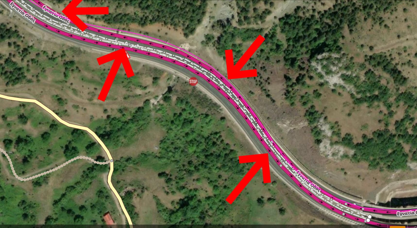
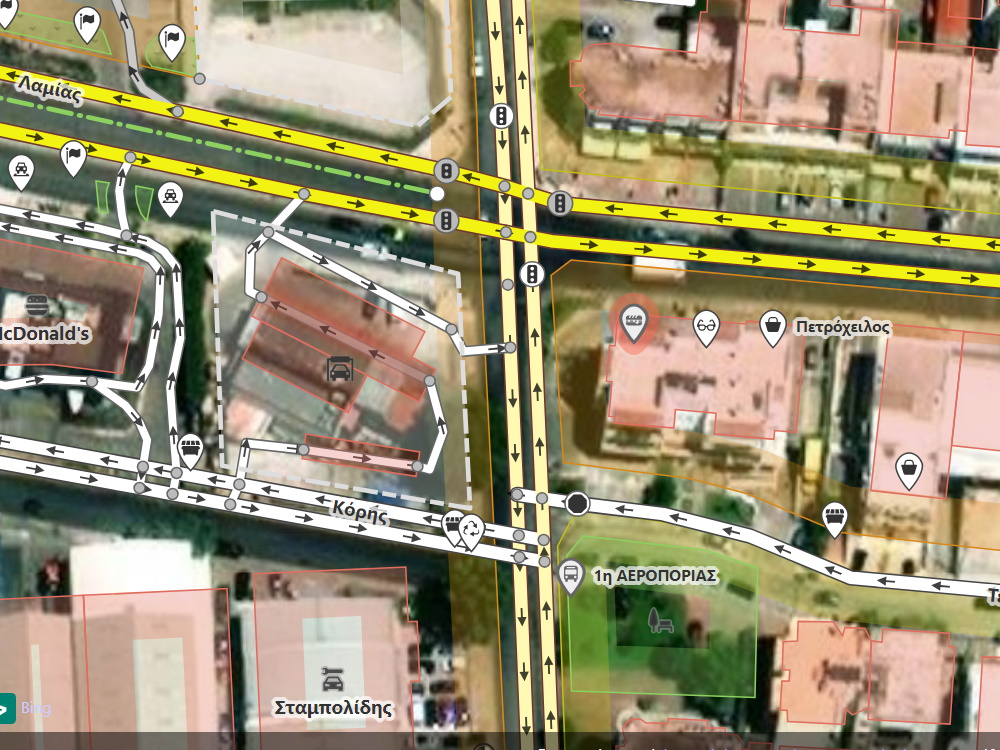
Εδώ έχουμε το “φαινόμενο” κάποιος να έχει επέμβει και να έχει διαχωρίσει τα ρεύματα κυκλοφορίας των οδών Λαμίας, Τιτάνων, Αεροπορίας, Κόρης, δρόμους στους οποίους υπάρχει ενιαίο οδόστρωμα χωρίς διαχωριστική νησίδα.
Το είχα ξανασυναντήσει στο παρελθόν αυτό το ίδιο φαινόμενο, το οποίο διόρθωσα χωρίς περαιτέρω συζήτηση. Υπέθεσα πως αυτός που το έκανε δεν ήξερε πως να θέσει τους περιορισμούς στροφών και ήταν ευκολότερο να δημιουργήσει 2 ρεύματα κυκλοφορίας.
@ika-chan : I know that you know nothing about these, you are only after me!
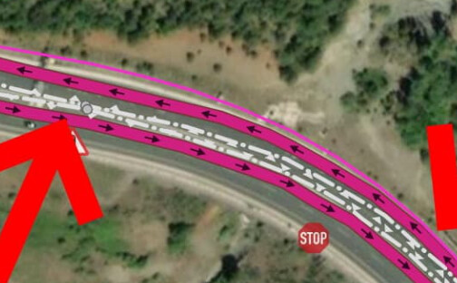
What I see here (in the image) is that the 2 carriage way’s are not on the centre line of each direction, squeezed up against the I think is double sided guard rail which can be tagged with a single guard_rail way as well using the both tag, albeit does not render in ID or JOSM or Carto. Proper would be that at least the carriage ways are ‘spread’ proper on the area:highway zone. Map that and it truly visualizes how off it is. Since I map bridge areas the Shift+B comes in really handy to get perfect distribution to get an appealing render.
(No inkling what these this thin pink lines are on the side in the image)
At any rate if this was mapped/traced on the same background imagery as shown in the picture, not all too picture perfect aligned but then What I see daily is Tom maps with Bing without offset correction, Dick maps with ESRI without offset correction and Harry, well he prefers very dated ESRI clarity to map his stuff and all do that in the same place so nothing is aligned to each other. Particularly when you get to urban zones it’s horrible, in real life building facades perfectly aligned, on OSM street one part up against the southern side buildings, the next up against the northern part of the street.
PS I use JOSM Shift+P to map perfect parallel ways which corrects for inner/outer bends inclusive.
1 Like
Although the mantra says that if there’s no ‘physical’ separation to map the way as single rather than split, here with left a tree row or hedge in between then right none mapped, if then the 3rd section does have that physical separation again I’ll let that be. Case in point we have a special type of T junction here very very wide for turn left, turn right, on and off, traffic islands are often only painted. The general accepted mapping style is here to draw per the natural flow of traffic which a renderer would not be able to emulate in a million years. This way what’s on the GPS screen is what the driver sees through the windscreen and the computed route overlays well with the GPS locator arrow.
My Navigator is good and having the GPS arrow though snap to the mapped way but it gets really awkward if there’s a close parallel way… confusion, suddenly the maxspeed warning flares up.
At any rate, I’m not going to do a back and forth and back and forth revert/restore fight. Got better things to do. Today a ‘tunnel’ when actually originally is an embankment was developed for a motorway and concrete walls were set where old ways cross, then when constructing the motorway on top of the embankment a cover/‘roof’ was layed on that intentionally left gap in the build up embankment. Is it then a bridge or is it then a tunnel? The German Community had a long winding discussion about this but to me, no soil, rock, a ‘natural’ layer between the road going over and the one going below makes the bridge and tunnel tags questionable. And it get’s funny when the road manager put’s signs up ‘low bridge’, our lowest is 1.8m height through the railway embankment, some 20 meters wide. Cycling through is hazardous… duck.
In short, sometimes a little pragmatism works.
The distances between 2 carriage way are steady along all the way of highways.
The gurd rail appearance is distorted.
I any way the result is awful!!!
In fact, I never touched the area that you accuse me of bad mapping. If you load changeset 140386220 in the JOSM reverter and look at the history, I never touched any of those roads.
I cannot allow this false allegation to stand. Map-Finder has a long history of uncivil and aggressive behaviour against me and I cannot let this continue, because that kind of behaviour makes it harder for me and others to try and resolve the issue.
c.c. @jimkats
I’m aware for quite some time now of issues between mappers in Greece. Including myself. Maybe it’s time to finally try and solve this? If so, a new topic would be required.
Because exactly as ika-chan says:
Note that this current post isn’t directed only at you map-finder. Is a general attempt for all issues us in Greek community are facing silently, that is there’s rarely an open discussion about the private fights that have an impact on how the mapper acts in OpenStreetMap.
@ika-chan do my english need extra translattion?
Did you read that I accuse you for changing this part of map?
I repeat: Did I accused you for changing this part of map?
I clearly said, that you are always after me and my changes on the map and you don’t see other’s changes. That’s very strange or possible you are partial to me.
BlockquoteI know that you know nothing about these, you are only after me!
.
@jimkats Βλέπω διαρκώς μια μεροληπτική στάση από τον ika-chan, σε βαθμό που βλέπω έναν εμμονικό έλεγχο στο τι κάνω.
Εχω εντοπίσει πάμπολες αστοχίες από άλλυς χρήστες αλλά δεν έχω δει τον ika-chan να ασχολείται με αυτές, παρά μονο με ο,ιτ κάνω εγώ. Σε βαθμό ενοχλητικό.
Αποκορύφωμα της συμπεριφοράς του ήταν κάποιες αλλαγες (απαγορεύσεις λόγω μονοδρόμων) στην Εύβοια. Μου έκανε παρατήρηση ιδιωτικά, του εξήγησα πως έχουν τα πράγματα (διπλή διαχωριστική στο οδόστρωμα) αλλά με αμφισβήτησε, και εμένα και τον ΚΟΚ και δημιούργησε thread στο forum.
Δεν είναι προσβλητικό αυτό να αμφισβητείς έναν αυτόπτη χρήστη και οδηγό;
Όσο για το “uncivil” θα του το επιστρέψω σε “obsessive”.
Θα πρέπει να υπάρχει λόγος γι’ αυτή την μεροληπτική στάση. Μήπως θυμάσαι πώς ξεκίνησε η όλη ιστορία; Π.χ. πείραξες κάτι που εκείνη είχε επεξεργαστεί; (και ναι, έμαθα ότι είναι γυναίκα και όχι άντρας).
Τυγχαίνει πολλές φορές όταν κάποιος επεξεργάζεται κάτι που ξέρει, και έρχεται ένας άλλος και το χαλάει, να υπάρχει μια αντιμαχία που συνήθως δεν φτάνει σε επίπεδο επέμβασης του DWG, αλλά μακροπρόθεσμα σε κυνήγι.
For the record, I already decided to stop touching the turn restrictions in Greece, in order to de-escalate the situation. If they are signed, then source=* should be set to “sign” or “Mapillary (YYYY-MM-DD)” [i.e. today’s date]. Relations support the source=* key: that will reduce the risk of confusion.
I think I said something similar before. Oh wait, here it is: Turning left on a double white line - #16 by ika-chan
Λοιπόν για να ξεκαθαρίσω κάποια πράγματα:
- Όταν γράφω στο 1ο αρσενικο γένος είναι επειδή αναφέρομαι στον “χρήστη”, ανεξαρτήτου φύλου.
- Οταν κάνω επεμβάσεις, δεν ψάχνω να βρω από ποιον έγιναν οι αλλαγές ώστε να επέμβω.
- Στο παρελθόν η ika-chan με κατήγγειλε στο forum πως έκανα κάποιες συγκεκριμένες αλλαγές (στις διασταυρώσεις) χωρίς να ρωτήσω την ελληνική κοινότητα. Της παραθέτω το thread (στο παλιό forum) στο οποίο είχα ρωτήσει το πως θα έπρεπε να γίνονται οι αλλαγές. Δεν απολογήθηκε ούτε ζήτησε συγγνώμη για το λάθος της καταγγελίας.
- Το πιο πρόσφατο, αυτό με την διπλή διαχωριστική γραμμή. Της εξηγώ τον ΚΟΚ, τον οποίο ΔΕΝ γνωρίζει, δεν την ικανοποιεί η απάντηση και συνεχίζει στο forum. Δεν είναι σχήμα οξύμωρο να κάνει οδικές παρεμβάσεις κάποιος που δεν γνωρίζει τον ΚΟΚ της χώρας στην οποία επεμβαίνει;
- Στην Ανατολική Αθήνα έχει πάει κάποιος και έχει προσθέσει σε κάθε κτίριο το tag “building=roof” το οποίο δεν δηλώνει πως είναι η οροφή του κτιρίου, αλλά ένα επιπρόσθετο οικοδόμημα (A building open on at least two sides). Το σωστό είναι “roof:shape=*”. Η ika-chan δεν το έχει παρατηρήσει αυτό, παρά μόνο ό,τι κάνω εγώ. Εδώ πηγαίνει το “@ika-chanspeech_balloon : I know that you know nothing about these, you are only after me!”
Καταλαβαίνω. Θα το πάω σε άλλο επίπεδο τώρα και θα ρωτήσω εάν η ενημέρωση που λες ότι της έκανες για τα λάθη της, όπως για τον ΚΟΚ και την οροφή (που λανθασμένα φαίνεται να έχει εκληφθεί ως ταράτσα), με επικοιδομητικό τρόπο; Εάν υπήρχε πρόβλημα στην επικοινωνία καιρό τώρα, γιατί δεν ενημέρωσες την υπόλοιπη κοινότητα για το συγκεκριμένο ζήτημα;
How could I know about that? If someone else mapped buildings with “building=roof”, then you should ask the user who did that, and not me. And please, provide examples of changesets that you feel are concerning.
Blockquote How could I know about that?
How you should know? In the same way you learned about my changes that you found wrong!
This is the proof of your obssesion about me!!!
@ jimkats
Τα λάθη με το tag roof έχουν γίνει σε τόση μεγάλη έκταση που ευελπιστούσα πως κάποια σαν την ika-chan που ανακαλύπτει τα (κατα την κρίση της πάντα) λάθη μου, θα το ανακάλυπτε και αυτό.
Λίγο αυθαίρετη σκέψη εκ μέρους μου, αλλά βλέποντας το “κυνήγι” που τρώω από την @ika-chan , έλεγα πως θα το ανακάλυπτε και αυτό, πως δεν ήταν μεροληπτική και εμμονική στο να ψάχνει μόνο τα δικά μου changesets.
Και άντε πες μπορεί να μην ασχολείται με τα κτίρια παρά μόνο με τους δρόμους, που κυρίως ασχολούμε και εγώ! Φευ! Ο άλλος στα νότια προάστια μην μπορώντας να αποδώσει απαγορεύσεις δεξιόστροφες ή αριστερόστροφες, σχεδίασε 2 ρεύματα κατεύθυνσης σε οδοστρώματα που δεν το δικαιολογούν. Αρχικά το είχα εντοπίσει στην Καλαμακίου, αργότερα το εντόπισα και στις άλλες οδούς που παρέθεσα στο screenshot.
Εν κατακλείδι να γράψω πως δεν είμαι αλάθητος. Δέχομαι την κριτική. Για αυτό συμμετέχω και στο forum. Απλά εκνευρίζομαι να βγαίνω στα μανταλάκια από την συγκεκριμένη χρήστη για θέματα τουλάχιστον που έχω ενημερώσει την κοινότητα ή απλά εφάρμοσα τον ΚΟΚ, όπως να βλέπω πως άλλα τραγικά λάθη περνάνε απαρατήρητα χωρίς καμία νύξη.
I would be ready to address any issues if you could kindly stop with such defensive and somewhat paranoid language. I don’t see that kind of attitude on Wikipedia. Again, I already decided to stop touching the turn restrictions in Greece but adding the source will prevent confusion in future.
I am focusing on the unmapped woodlands now.
I really don’t mind you to touch anything, unless you learn the local rules.
I never made any special thread for what you think by mistake or misunderstand, as you did for me.
If I wanted to insult you, I would write at the community right after I found out that you don’t know the local (and paneuropean too) Highway Code, about double white line.
But you did it by yourself and all the members of the community found out what you don’t know.
It is an act of wisdome to admit your false on this subject.