During my hikes last year I saw a lot of streams I could easily step over, then a fortnight later the same ‘stream’ overflowed the area.
for you “often” is this one time before in Romania? ![]()
To clarify for others - back then I deleted a lot of mechanically imported trees in Bucharest, many of which were obviously incorrect (standing on the streets, buildings, sometimes 15 trees instead of 5 in real life, so on), and remapped some of them as wood areas - and my mistake is that I didn’t talk with community before, but after reverts and warning-block (not a proper ones which you had, just saying) I’ve chatted with them in Telegram and indeed most people agreed that such tree mapping didn’t make much sense. It’s just that I started cleaning the map before asking people, that’s my bad, yes.
friend? I don’t even know who this is ![]()
ok, great you didn’t do it lots of times, and important you are writing here and explaining those accusations against you are unfounded. It is important people are researching well before publicly accusing others for vandalism. Still, in the case of the deleted cliffs in Luxembourg it is seems they were not justified (at least the edit comment doesn’t suggest it) and these should be reverted.
UPDATE: @dpolovinkin thank you for reverting the deletions of cliffs in LUX!
Just to answer that question - I don’t do any “special handling”** on cliffs on my raster or Garmin maps; the representation on raster maps is unchanged from how OSM Carto did it 10 years ago. I’ve not actually looked at how “small diameter” rock pillars are mapped in OSM - there aren’t too many of them near me! “large diameter” ones I’d expect to see as “circular cliffs” but I haven’t investigated that either.
** “special handling” means looking at other tags and seeing if some other representation would be better.than he vanilla one for that feature type. As an example, the “buildingness” of a ruined building is shown slightly differently to a regular building, and “ruined” can be implied by 3 or 4 different tagging styles.
The difference here is that we have a pile of different tags to explain what’s going on here - river vs stream, intermittent, flood_prone and more.
Is there anything similar for cliffs? How high does something have to be before it counts as a “cliff” in OSM? My naive thought as a mapper and with “what people map as cliffs in the UK” would be 3m vertical or so, but there might be different opinions elsewhere.
Is anyone aware of an attempt in OSM data to say “how much of a cliff this is”?
With quite accurate lidar data available, micromapping cliff height is not unrealistic.
2 Likes
I just did an on-site estimate in the linked place above. Administrative GIS allows me to make measurements by drawing lines that query the terrain model to create a height profile. Comes out it is 50 m instead of 40, at 80° incline. This cliff here is said to be 900m high (Wikipedia), administrative GIS gives me ~650m, also at 80° incline. In another topic though I got told that adding such data will stain the whiter than white waistcoat of osm, so I refrain from corrections.
LIDAR based hill shading says little actionable about height, contour lines can give a rough estimate, but only for high cliffs. LIDAR alone is also prone to misperceptions. Sometimes there is no cliff at all, just a steep embankment kind of terrain, @tekim already mentioned that above. Some kind of local knowledge should be there.
There are a number of cliffs where I map that I have doubts. While they got mapped from LIDAR, I have to visit them, one by one. I already could falsify a few, but progress is slow. All that said, cliffs are useful in maps, their presence can change how to approach a site or can save a large detour. Not all users have high res hill shading in their apps. With SRTM even the 50m cliff cannot be seen.
So yes, adding height to cliffs very much welcome! Less than 1% of cliffs have that.
I agree that some of the trees in Bucharest could have been plotted as areas instead of individual trees but not all and part of those were not reverted. It’s not only these though, you also deleted a lot of buildings with an offset that could have been just repositioned very easily. I bet even more easily than recreating them (filter elements > move).
2023.08.14 cliffs Luxembourg OSMCha
2023.08.17 trees Bucharest OSMCha
2023.08.28 trees Bucharest Changeset: 140499434 | OpenStreetMap
2023.09.12 trees Serbia Changeset: 141181140 | OpenStreetMap
2023.09.12 trees Bucharest OSMCha
2023.11.16 buildings Russia OSMCha
2023.11.26 buildings Russia OSMCha
2023.12.04 buildings Montenegro OSMCha
2023.12.04 buildings Montenegro OSMCha
2024.01.17 cliffs Luxembourg OSMCha
2024.01.17 cliffs Luxembourg Changeset: 146370525 | OpenStreetMap
Isn’t this often? And I can fo further back in time if you insist…
As I said you talked about someone who thinks I excessively add paths only thanks to LIDAR (which I’ve demonstrated existing), he also started deleting cliffs after your deletions from 2023.08.14, you came here talking about cliffs + my blocks even though there is worse elsewhere and you don’t live here, finally here apparently he knows you are Serbian. So yeah, you seem knowing this guy who also does massive deletions.
Agree, but contributors who value these topographic elements I’m convinced they try their best to plot complex shapes. Personally I do try to keep them simple and with a low ratio of nodes, avoiding plotting every corner and every height. On very large distances in mountains/large hills, I only plot the highest, lowest and most relevant in between. When close enough and surrounding roads/trails only top/low. When tight, only one line of cliff.
Yes there is a height description in OSM Wiki: above human height with a risk of danger for various users (horse riders have a higher risk than pedestrians). Also in Wiki’s discussion, there is a contributor who talked about plotting complex cliffs, some being not a straight drop but dangerous anyway.
I would like to emphasize this concept of “various users” i just talked about. Off topic but important. Across my decade of contributions I noticed several contributors only have their point of view but forget there are other kind of users using OSM. Pedestrians, cyclists/mountain bikers, horse riders, drivers, tourists, etc… Each might find something useful but not another. We really need to avoid subjective interpretations and focus on facts: does it exist/can it be recognized and how to tag it properly thanks to a clear definition.
Yeah tris thread is about lidar cliff mapping, not about whether I deleted something among my 2k+ changesets, so I don’t know what point are you trying to make going through this all to collect places where I deleted something heh…
And I’m Russian, not Serbian :)))
Indeed about cliffs, that you deleted and these are part of your other mass deletions that have been reported by others. Since you questioned my “often”, I just replied politely to your doubts by pointing out each of them with a date to make a clear statement. :)))))))))
On the rest, good then…
it’s getting old already… I think the only time I was actually reported for deleting something was this one time in Romania, which I described.
And you don’t have any info or context about other deletions which I did, whether I was remapping something, already talking with the author about changes or else. So basically stop imagining things while trying to paint me in bad picture. “clear statement” for real…
But overall, I’m happy that the thread sparked quite some discussion here! ![]()
Your deletions from 3 days ago are rather recent. The bad ratings and comments from others on the CS and on this post are self explanatory, they were justified. Anyway…
Yeah overall, thanks for the discussion you all ![]() and @dpolovinkin for reverting your deletions. It’s not worth staying in conflict and admittedly you came here by yourself, yet I don’t understand why you created this post since we had a discussion 6 months ago where i took the time to explain you (calmly IMO) everything what people here said and with examples. Different opinions are natural but subjective interpretations of needs in a shared open project is irrelevant.
and @dpolovinkin for reverting your deletions. It’s not worth staying in conflict and admittedly you came here by yourself, yet I don’t understand why you created this post since we had a discussion 6 months ago where i took the time to explain you (calmly IMO) everything what people here said and with examples. Different opinions are natural but subjective interpretations of needs in a shared open project is irrelevant.
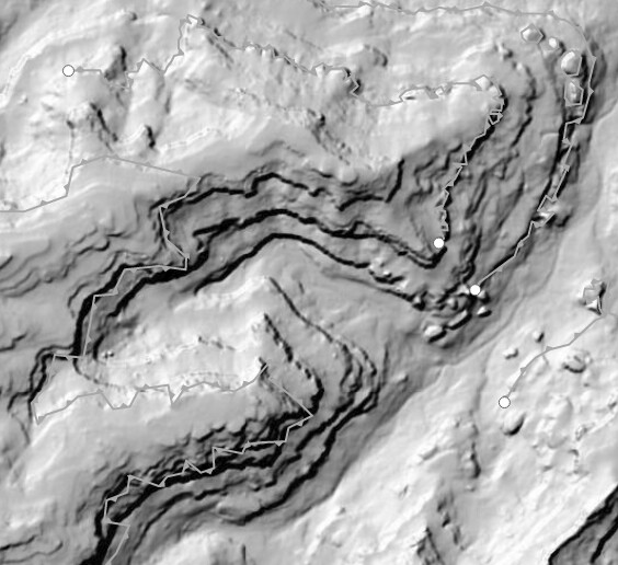
I’ve walked there (the Red Rock example) and they aren’t helpful.
But they’re also incorrectly mapped from satellite imagery. Some of those lines are cliffs and others are not, so it might be different from other cases: Many rock features drawn as `natural=cliff` but not correctly
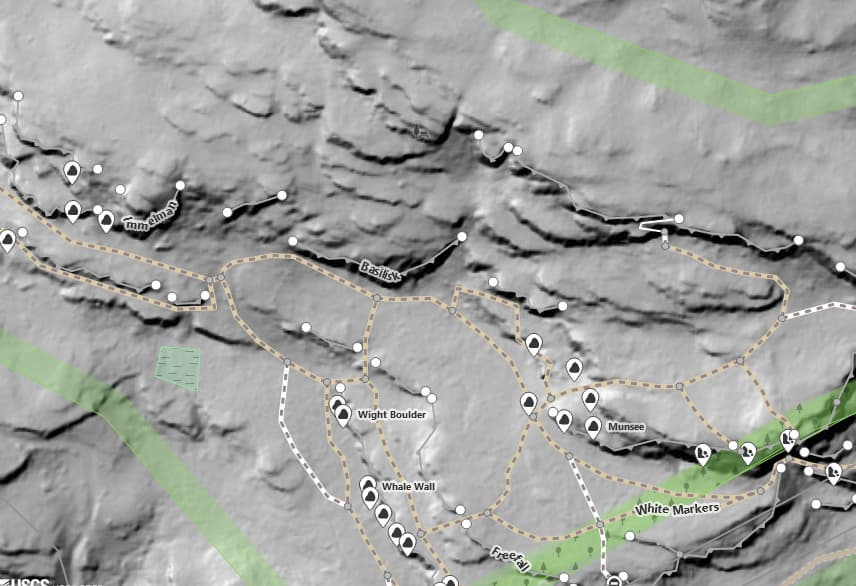
It also clutters the map so much that it’s more difficult to see the notable climbing cliffs that I’m aiming for. Using LIDAR hillshade imagery for the background image, with OSM notable cliffs overlaid on top is much more useful, like this:
I’m not sure if the other two examples are really cliffs, either:
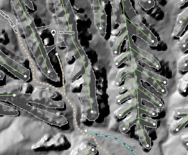
I’m not opposed to mapping all cliffs, I guess, but they have to actually be cliffs. If they’re all connected into a continuous polyline, it’s unlikely that they’re actual cliffs.
3 Likes
Replying to the OP: Mapping like this adds nothing of value. It merely duplicates what the source LIDAR data already states in a more convenient way.
3 Likes
You are questioning the entire OSM.
Mapping roads does not add any value either. It merely duplicates what thousands of other maps already show.
2 Likes
We should change name to OpenTopoMap. Put contour lines in already!
BTW, can somebody point out where on how to make map files (for Osmand etc) but with all extraneous details like this filtered out?
There is (as always), a few rhetorical responses on this thread, so I thought it was worth a shot trying to render cliffs in a way that does not clutter the map in those micro-mapped areas.
Because there’s no way to actually differentiate a natural=cliff from one another, on Opensnowmap style (just locally, this is not live) I tried to make a fainter rendering on cliffs in areas where they are very densely mapped (OpenStreetMap).
So, instead of this rendering query for cliffs:
        select  geometry, type
        from osm_natural_ways
        where type='cliff'
I tried this:
        select  count(*) as density, st_collect(sq.geometry) AS geometry, type
        from
        (Select geometry, type, st_clusterdbscan(geometry,100,1) over() AS cluster
            from osm_natural_ways
            where type='cliff'
            and geometry && !bbox!) sq
        group by cluster, type
And split the simple style to this (isolated cliffs stay the same, densely mapped ones are smaller and less opaque):
#land_features[zoom>12] {

    [type='cliff']{
      [density > 8] {
        [zoom <=16]{
          opacity: 0.4;
          line-pattern-file: url(img/cliff.svg);
          line-pattern-transform: scale(0.6,0.6);
        }
        [zoom >16]{
          opacity: 0.6;
          line-pattern-file: url(img/cliff.svg);
          line-pattern-transform: scale(0.9,0.9);
        }
      }
      [density <= 8] {
        opacity: 0.6;
        line-pattern-file: url(img/cliff.svg);
      }
    }
}
Simple query result:
Elaborate query result:
More importantly, this is not that expensive, except in densily mapped areas:
Area with cliffs:
- Simple query: 1.4ms
- ClusterDBScan query: 16.1ms
Area without cliffs:
- Simple query: 0.17ms
- ClusterDBScan query: 0.22ms
7 Likes