Hi community!
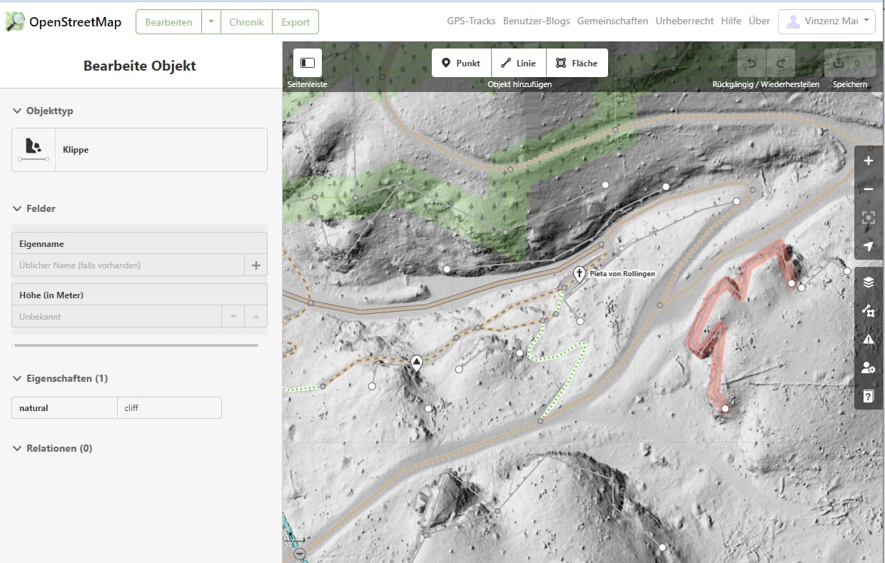
There is one issue which is quite noticeable in Luxembourg and I’d like to start a discussion to find a consensus with the community of what should be done with that - user @SHARCRASH for quite some time (3+ years at least) was adding a lot of cliff lines all around Luxembourg and near it’s borders.
For example, it is very noticeable in different forests, for example here you can see for yourself the state of the map because of that, here and here.
If we zoom in, you see how it looks like in this place.
I deleted a bit of them half a year ago, which lead to reverts and big and heated DMs to me of why I’m in obviously the wrong. You can also read details of why this user was blocked repeatedly, especially the last one. So this thread is kinda the solution @woodpeck was talking about there.
Let’s decide if there is any value of keeping/adding any kind of such edits on the map, and how is it affects the end-users of OSM, who see all those cliffs all over the map in forests right now, or should they be partially/completely removed from the map. Thanks!
They shouldn’t be removed without on the ground knowledge that there’s no cliff.
The topography of Luxembourg (and across the border) contains lots of cliffs, natural and the result of iron mining (with a great part of surface mining) in the southern part…
Some examples:
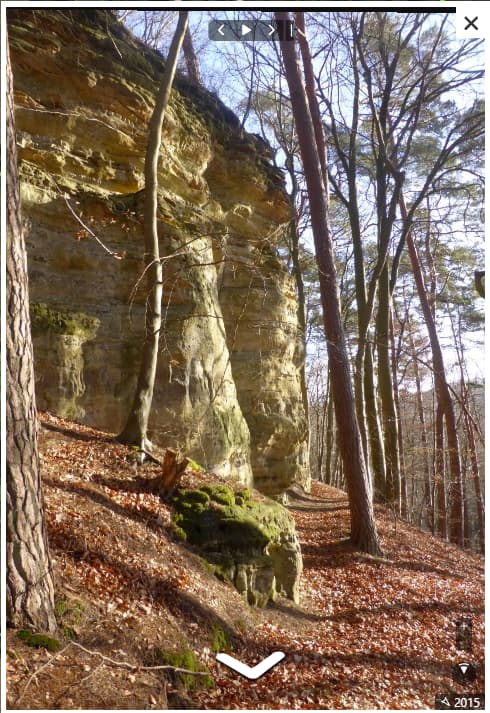
Please have a look at Mapillary cookie policy use (please follow the hiking and at the end the next picture series) for cliffs in the forest - in my opinion correctly mapped by @SHARCRASH .
Yeah, I guess shouldn’t have deleted right away, but as I understand, it’s kinda an issue in Luxembourg…
I’d rephrase that for first things to be first - were those places checked “on ground” when they were added in the first place, or just mapped according to LIDAR and that’s it? I think it’s fair to say that with 99% chance they were not checked in person before
No, I mean I understand there are cliffs of course, and some of them should be mapped.
It’s more like two questions, at least from me.
First, especially when you guys noticing it should be checked on ground before deleting… but was it checked on ground before adding in the first place?
To make a point clear, imagine - if I for some reason mapped a lot of places which do not exist or added garbage data to the map or did a lot of weird micromapping or whatever, then after a year someone noticed that and decided to clean the map - is it fair to say to the “fixing” person - “waaait but did you check the data in place before deleting? can’t delete nothing otherwise! v-word!”?
The situation here is different, but I can be seen as quite similar.
But most importantly (as I understand lidar is probably correct and mostly there ARE some cliffs there) - but does the map need micro-mapped stuff like this? And there are a lot of places in such a style. What exactly does it mean? Two-meter long “cliffs”? Or is it just a small ground elevation somewhere in the forest? That’s the main issue at least for me, which I can’t really understand. And it’s cluttering the map quite a lot…
And to make it clear - I’m not even living in Luxembourg, just traveling a lot and was there half a year ago and noticed while biking around the forest on the south that it’s much harder to read a map with all this cliff-cluttering, didn’t understand what it was, so checked it out on OSM and saw this situation all around Lux
I just thought that it’s quite strange, and hurts users which use the map (my friend even asked me “what is this mess here” looking on the map). And there were reports of such a mapping before as it seems looking on blocks of this mapper, so I just decided to make a thread to at least people to discuss here what should or shouldn’t be done with such a micro-mapping.
Additionally, it seems that there is also quite some mapping of trails which are not really there anymore, as one mapper in Luxembourg said to me in DM, apart from that’s all is quite an issue there - lidar-based cliffs and non-existing trails.
Micromapping isn’t wrong. Micromapping by LIDAR isn’t wrong too.
I hadn’t had any problem with my Wahoo Bolt while cycling in the south of Luxembourg and I hadn’t had any problem with my new Garmin Edge - both using OSM-based maps.
Here this user didn’t map only the cliff he mapped that path too (Way: 676274224 | OpenStreetMap), clearly an existing one.
Please have a look at the Mapillary photo series. Neither two-meter long nor a small ground elevation.
And yes it seems there’s great LIDAR data in Luxembourg that enables to map such cliffs from LIDAR.
A hillshade of an elevation model (derived from lidar perhaps), is an excellent source for mapping some trails. In the US I use the USGS 3D Elevation Program data hillshade quite frequently for this.
Worth mentioning that an other source is mandatory, there are a lot of historic trails that no longer exists that can be perfectly seen with such data.
Yes, of course. I should have mentioned that. One should have some first hand experience, see some Strava heat, or have a trail in an official source (with compatible license).
I don’t generally have a problem with micro mapping, but…
It is hard to tell from the hillshade (lidar) how high these cliffs are. If they are only one meter or so (I am unsure what the exact cutoff should be), they probably shouldn’t be mapped, or at the very least, they should be tagged with their height. Also, to be a cliff it should be nearly vertical, and in some of the cliffs that have been mapped it is not clear that they are. Maybe they are, maybe they are not.
BTW, there are lots of streams that one can step over around here (US) that have been mapped.
Fact is, it can look really odd on maps, but gives a good idea of the landscape. In fact I think I like it but in the future I’ll maybe try to render short cliffs a bit smaller on Opensnowmap
We don’t map for the render and we don’t leave anything out for the renderer. OSM is not a map, but a geodatabase. If you think this is overloaded, then render your own map without natural=cliff.
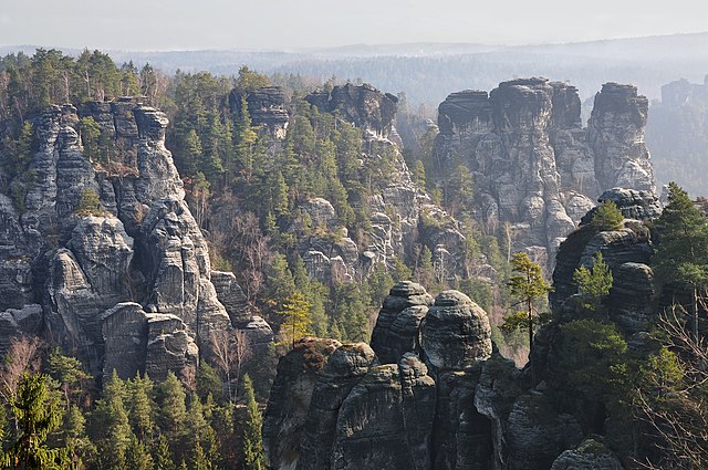
Oh yes - I find these examples really harmless. I recommend a trip to Saxon Switzerland to anyone for whom this is already too overloaded.
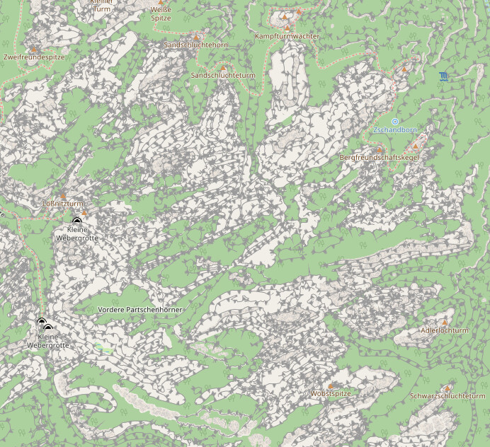
If you think that’s bad, have a look at the southwestern United States. It’s an absolute mess of excessively mapped cliffs. See here, here, here, and discussion here:
It’s not even really wrong, it just shows that mapping every cliff in a landscape that is all cliffs basically amounts to custom drawn contour lines. Certainly doesn’t make for a useful map.
maybe the cartographic visualization of cliffs should be less impactful in a landscape that is all cliffs? I do not think it is wrong to map cliffs where they are, and if there are many, unless the map takes particular precaution, it will look like a black blob as the standard way to show cliffs is with high prominence, calibrated for areas where a cliff should be highlighted because there are not so many.
I wouldn’t be so sure about this. Certainly you would want to know about all cliffs when walking there.