I like their rendering of intermittent and “mainly dry” for lakes and think it could also work where water sometimes flows.
2 Likes
There’s some pretty consistent rendering of wadis. The historical USGS topo style above covers the area of the feature with reddish brown dots.
The current style used in the USGS National Map uses a light brownish gray dot pattern with a darker brownish gray dashed border:
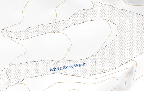
Personally, I like the dashed border because wadis often have well-defined banks and the border makes them stand out. The banks are important aspects to map because they’re often steep and sometimes vertical, so they can be barriers to travel.
But I think any rendering within the range of styles we have here would be good.
4 Likes
Is there something more we need to do before documenting this on the wiki?
I was wondering about that too.
It seems to me that the discussion here, along with the images that have been posted in this thread, would be pretty good content for a proposal page on the wiki.
5 Likes
This has been a nice discussion. Appropriately, I just visited Death Valley and would like to improve the landcover mapping there, so how to map dry washes is very relevant. I gave some wadis a shot here: Changeset: 147998558 | OpenStreetMap. I attempted to follow my interpretation of the consensus in this discussion, using waterway=stream + intermittent=yes + ephemeral=yes for the linear way, and natural=wadi for the “riverbank” area. Feedback welcome.
I’m coming across a problem very related to dry washes while mapping that I think should be considered in tandem, so I’ll pose it here: how should alluvial fans be tagged? In many cases, at least in Death Valley, dry washes terminate in alluvial fans when they empty into a valley. See here, for example: the narrow washes in the mountains on the east and west terminate in broad fans as they enter the central valley. Meanwhile, the main north/south wash is a well-defined natural=wadi/dry channel in the north, but it spreads into an alluvial fan as it enters the dry lake to the south.

Should these fans also be tagged as natural=wadi? They share some of the same characteristics, like being shaped by sporadic water flow and having slightly more vegetation than other areas. But they’re also distinct in being delta-like rather than channel-like features. There’s an existing rare geological=alluvial_fan tag, documented here: Glossary of landforms - OpenStreetMap Wiki, is that alone sufficient? Maybe the tandem natural=wadi + geological=alluvial_fan? Another natural tag? Nothing at all beyond tagging heath, scrub, or sand as appropriate? (Most of the pictured valley is covered in sparse small bushes). Interested to hear what people think!
1 Like
Similar discussion which was one of my first forays into the community here
Using that discussion and the results of this discussion I would map the fans as part of the wadi and break out any further detail using the geological=alluvial_fan for those specific features as you see fit to delineate them. Given the low relief and ephemeral nature of the features you can decide whether the alluvial_fan is “in” the dry_lake or defines the shoreline of the dry_lake.
Interested to know how others might use the guidance here to map the features.
Well, I wrote the Glossary of landforms - OpenStreetMap Wiki and mapped the other two instances of geological=alluvial_fan. We’re definitely in the realm of Any Tags You Like here, and not anything settled or agreed upon.
I also visited Death Valley and Panamint Valley a little over a week ago, and spent most of my time there talking about alluvial fans with a geologist friend, so I’m familiar with the specific alluvial fans we’re talking about. Here are some observations I’d make.
The alluvial fans in Death Valley and Panamint Valley vary in composition from coarse gravel, to cobble, to small boulders. The size of the rocks in some of the fans is really impressive and says a lot about the power of floods that can come down those canyons!
As you noticed, there is some plant life on the fans. It’s mostly Creosote Bush, but also some Brittlebush and some other stuff I couldn’t identify. In some places the vegetation is relatively sparse and in other places it is relatively thick.
The picture you posted shows not just alluvial fans, but also a classical “bajada” on each side of the valley where the alluvial fans overlap and join together. It’s really hard to tell where one fan ends and another begins. In fact, the big fan just below the middle at the right of the picture is actually combined from both Titus Canyon and the adjacent Fall Canyon just to the north.
This poses some challenges if we try to map these features in OSM.
The boundaries are indistinct and likely change with each new flood, so mapping the boundaries would be pretty arbitrary. Also, the fans mostly don’t have distinct identities or names, so even identifying them as individual features is also pretty arbitrary. (The Titus/Fall fan is a good example of a fan that is indistinct and doesn’t have a verifiable name.)
That’s how I ended up using a single node for the Lucy Gray Fan, which actually has an official name. I used a way to map the outline of the Cedar Creek Alluvial Fan but I think that was a mistake and that mapping it as a single node would be better.
We could use descriptive tags to map the surface features. Maybe natural=scrub for the areas with vegetation, and natural=gravel or natural=cobble for the areas without. Sadly, we don’t even have a single use of natural=cobble to tag an area of loose stones of a moderate size. In any case, these fans are definitely not natural=sand. I don’t know where people got the idea that the deserts in the US are all sand, but there sure is a lot of it mapped in OSM in places where it shouldn’t be!
Personally, I wouldn’t map these fans as wadis, and certainly locals wouldn’t call them washes. One of the defining characteristics of a wash (i.e. wadi) is that it has banks on either side. Alluvial fans are just the opposite of that, where the sediment radiates out from the mouth of the canyon. On the other hand, the waterway down the middle of this valley is Death Valley Wash, and THAT should certainly be mapped with natural=wadi.
2 Likes
We actually spent quite a bit of time discussing this when we were out there recently.
First off, those fans are a lot steeper than they look in aerial imagery. There’s about 1000 ft of elevation in the Titus/Fall fan I mentioned above. That’s enough to call it a mountain in its own right!
There’s not a lot of evidence for the shoreline of the historical Lake Manly at the north end of the valley shown in the picture. I suspect that’s because the features have either eroded or been buried by more recent sediment. Maybe there’s something out there if you really search for it, but we didn’t see it.
But at the south end of Death Valley near Badwater, you can spot erosion lines from Lake Manly on the flanks of the mountains, and most notably on Shoreline Butte.
It’s probably a topic for another thread, but there was a recent conversation on OSMUS Slack about how to map Tulare Lake and specifically where to put the boundary. There was some consensus that it could be mapped at the historical high water point, and not necessarily at the current water level (which is changing rapidly).
Definitely make the terminus of the alluvial fan the defining boundary of the natural=wadi at that point. The fans are distinctly fan-like while the wadi is the reworking of sediment influx from them when water is present. My guidance at least…
Best I can see that’s available is natural=blockfield even though it doesn’t describe the genetic origin of the alluvial fan.
2 Likes
Yes, and natural=blockfield is specific to exposed rock that has eroded in place to become a field of boulders. That’s a very different process from the deposition of boulders in an alluvial fan, so I don’t think we’d want to use it here.
Yeah I think I agree. I definitely mapped the middle waterway in the above image as natural=wadi: Way: 1255489183 | OpenStreetMap. I’ve also added a couple of natural=wadi canyons in this changeset: Changeset: 148035956 | OpenStreetMap, and converted the existing incorrect natural=sand polygon along Furnace Creek here: Changeset: 148035956 | OpenStreetMap. I ended up adding surface=gravel, cobble might’ve been better, but either seems like an improvement over sand.
2 Likes
For the alluvial fans, I haven’t tried mapping the larger bajadas yet, but I think one large, unnamed geological=alluvial_fan polygon is probably the most sensible way to map it. I suppose you could also add nodes if you wanted to name each one, or arbitrarily break them up just for ease of mapping. I did map a some of the alluvial fans that had somewhat more definition, again with surface=gravel, like the big one at the outlet of Furnace Creek (there really is very little plant life on this one, although there’s actually some development, namely two of the park hotels): Way: 1256468840 | OpenStreetMap.
1 Like
What can you say about the incline, when you compare those. Is this a reason to choose the one or the other.
I’m very late to this party (i found this discussion via willkmis’ changeset comments), but i just wanted to say that I think natural=wadi is a pretty good solution for the area features. Distinguishing between “dry streams” and “dry rivers” is unnecessary. And I think the linear features should definitely remain waterway=river/stream.
And a general comment/rant about NHD data, which someone mentioned earlier in this thread: it drives me nuts when I find that people have dumped ALL the streams from a watershed into OSM: Every tiny little gully, with irrelevant “reach codes” and streams split into 100 segments. I’ve done some NHD imports myself, but I try to only grab the named streams and other significant valleys. (Sadly, NHD does not include “Canyon” names, so I have to find those using USGS maps or GNIS points.)
2 Likes
It’s taken a while, but I’ve put together a draft proposal for the natural=wadi tag based on this discussion.
https://wiki.openstreetmap.org/wiki/Proposal:Natural%3Dwadi
I would be very grateful if anyone from this thread would like to contribute to the proposal! If I didn’t manage to capture all the information from the discussion, please call that out or edit the proposal to include it!
7 Likes
That is a very good first draft. Thank you!
1 Like
Looks good to me.
1 Like
Excellent draft, it does a good job of capturing the details without being too verbose. One suggestion if possible…alongside the photo examples include a sat image capture showing how the aerial view translates to the ground view. Most mappers will be using the sat image so this does a good job of connecting the two and why the distinction matters. Again, just a suggestion if it’s possible to help clarify.
3 Likes
Yes, looks good, one suggestion I have: create a new paragraph “definition” in the text part and move the text from the template there, and put a oneliner in the definition field of the template. This is usually not more than a few words (it must not be complete, but should be very concise)
1 Like
There are a couple of aerial images in this thread that I didn’t include in the proposal because I wasn’t sure about license compatibility.
Is it OK to take screenshots from Bing and post them in the wiki?