I think all the references make it clear that “wadi” and “wash” really mean the same thing (although “arroyo” has other issues). Especially the link to Oman where Salalah escarpment directs flow from the highlands to The Empty Quarter, which is indistinguishable from an aerial picture from the US Southwest. Here’s what that looks like:
The most recently active channels are a lighter color and the older/abandoned channels are slightly darker. I don’t know if the processes are the same, but I would guess that the coloring in Oman is the result of accumulated desert varnish, the same as in the US. The banks on either side are clear and distinct.
There’s not much vegetation out there at all, but if you zoom in you can see that there is some scrub in the wadi, primarily at the margins of the active channels. And there’s little to no visible vegetation in the higher ground outside the wadi.
I would map that with a linear way tagged with waterway=river + intermittent=yes through whatever looks like the most recently active channel, but with the expectation that this way is an approximation that could be wrong each time the wadi floods.
Then, I would map the area between the banks asnatural=wadi and hope that someday the renderers would do a good job of drawing that. Eventually, we would need a rendering that would be distinct from natural=sand, natural=bare_rock, or natural=ground.
For the area features we’re talking about I am preferring the tag natural=wadi over natural=wash for a few reasons:
wash is more likely to be mistranslated from English into something to do with cleaning in other languages (e.g. “lavar” in Spanish). I’ve not tried the auto-translate in these forums, but Google translate messes this up.
wadi is easier to search for. Googling for “wadi” brings up results related to the landform. Googling “wash” on the other hand brings up hundreds of results for a variety of things that aren’t the land-form – everything from laundry to hair to sanitation.
wadi is used in a wider swath of the world across at least north Africa and the middle east, whereas wash is only used in American English in the south west US region.
As someone from the very wet US north east I wouldn’t know what a “wash” was without having traveled to the south west. Without significant context most American English speakers would not identify the term.
I voted for wash, but If we had more choices and ranked choice voting, I would rank it third behind dry_watercourse, and dry_wash.
It’s interesting to keep in mind that what brought this up was a bunch of NHD washes in the Rockies, which are more of a gulch than a wash or a wadi.
That’s why I like dry_watercourse since it’s more generic and not a localized term.
Creating an OSM specific term is kinda nice because it avoids various regionalisms and we can make it what we want… it’s less nice because it’s less intuitive and discoverable. I would support one for sure but alas nothing is free.
Actually, your post in the river topology thread was just a catalyst to get me to write up something that has been bugging me for a long time. I run into all sorts of odd tagging for these features in the desert southwest – as you can see from the examples in the first post.
I have put a polygon around “Big Wash" near Oro Valley, Arizona with natural=wadi on the tag. Once the extracts for this area get published, I will down load them and update my map rendering to show natural=wadi the same as I show an area of sand. Probably not ideal but a fairly easy change to my style information.
For what it is worth, Big Wash drains into the Cañada del Oro wash which has been previously tagged with natural=river, intermittent=yes and water=river so you can see the difference in how I render that. My rendering is quite different than the usual OSM but it might be useful.
A side note.
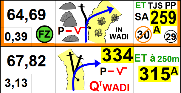
In cross country rally “wadi” is also used in roadbook tulips. FIM lexicon page 107 FIA page 101
Settting out a stage, survey is the important part.
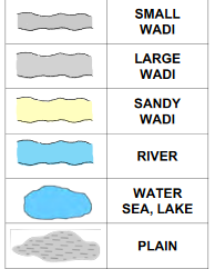
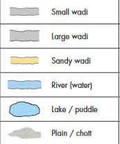
Hmmm. That map key distinguishes between a wadi and an sandy wadi. I guess we can do that with a surface=* tag. I don’t see how that would conflict with a top level natural=wadi tag.
In the paste the used paper roadbooks in black and white.
Now they start using color and tablets.
It is then only the color yellow that changes for small and large wadi when it is sandy.
I had speculatively mapped Coyote Wash near Ocotillo, CA with natural=dry_wash but I’ve just converted it to natural=wadi with surface=gravel since it’s too coarse to be sand.
I might suggest rendering these features using the same pattern as natural=shingle since they’re likely to be adjacent to areas with natural=sand and that would distinguish them. They’re also not likely to be next to areas tagged with natural=shingle. If we wanted to be clever, adding a couple of green specs in the dot pattern to represent the scrub would be really cool!
I don’t think OSM Americana has much rendering for natural features yet. I wonder if they would let us try out some rendering there.
.
The suggestion for shingle shown on the wiki looks a lot like my sand fill so I decided against just using it.
My sand fill is an svg with the dots a color of #f4e7dc. So as a quick and dirty update, I simple duplicated the sand svg file and looked on line and found an “analogous color” of #f4f3dc which is slightly green and changed the dots to that for the wadi fill.
If/when natural=wadi becomes accepted tagging I will look to do better (better default fill, honor surface=* tags on the polygon, etc.).
I have a very slow rendering computer (an old NUC with limited storage and RAM) which is grinding away now to import the most recent us-west-latest.full.pbf I hope to have enough time this evening to see how this renders.
It took a day longer than I expected. Apparently my edits the other day were after the extract for my area was started. Anyway, here is a render with Big Wash tagged as natural=wadi and Cañada Del Oro tagged as natural=river, intermittent=yes and water=river. Both have a “center line” way tagged with waterway=stream | river and intermittent=yes. Style is loosely based on older USGS topographic maps.
My wadi fill is way less in your face than my intermittent river fill. If wadi is accepted I’ll probably spend some time making things look better together.
I think that looks great. Just looking at the map, you would know what to expect in the location of Big Wash.
I have updated the Glossary of Landforms to reflect this discussion. Many things on that page are speculative, but at least these entries now reflect the discussion so far.
That area is in the higher elevations of the semi-arid Sonoran Desert, so no areas of just sand near by. If someone knows an area where there is both a wadi with this tagging and adjacent sand area I can point my PDF generation scripts to it.
It doesn’t look like this forum allow uploading of SVG files but I guess I could convert my sand.svg and wadi.svg to JPG or PNG and upload them. But this is just my personal rendering, the rendering by OSM Carto and others would be different.