Pedestrian lane on the road

For me, there’s a difference between a footway and a sidewalk. A sidewalk is a structural element of a street, next to it. How it’s separated from the carriageway is probably down to local legislation. In Germany, 99% are separated by a kerb and raised above the level of the carriageway by ~12cm. A sidewalk is usually only used by pedestrians, but it can be a shared space with cycleways, in which case it’s still a Sidewalk. Further structural elements include the carriageway, shoulder and verge. Then there’s also the embankment, the median strip and maybe others I’ve forgotten, or simply don’t know the English word for.

A footway, on the other hand, would be more like a space on the street “where can I walk”. So if there’s a sidewalk, then the footway would usually be on the sidewalk. Since there’s usually no sidewalks outside cities in germany, most of the time you either have to walk on the shoulder or the road verge.

This would mean, for me, that sidewalk:<side>=yes implies something like footway:<side>=sidewalk, much like we have cycleway:<side>=lane/track and track would mean, at least over here, on the sidewalk. I completely agree that in case of a footway painted on the street, footway:right=lanesounds like a sane choice if sidewalk:left=yes always implies footway:left=sidewalk. And the problem is: it doesn’t, because footway=* is a key to precise a separately mapped highway=footway / highway=path and not to specify where pedestrians are supposed to walk

We have similar issues with the cycleway-key. We use cycleway:<side>=track, but over here, in the majority of cases, this “track” is actually the sidewalk, so cycleway:<side>=sidewalk would make more sense. I’m sure it’s not the same all over the world, but it’s like this in Germany. But then we also have cycleway=crossing, which is kinda misusing the “where are the cyclists are supposed to drive”-key as a “is this cycleway track crossing the road”-kinda key.

So taking this all into consideration, I think the only way to tag this right now is to use lanes:

highway=residential
sidewalk=no
lanes=2
vehicle:lanes=yes|no
foot:lanes=no|yes
oneway:lanes=yes|no

As much as I’d like sidewalk:right=lane to be valid, it seems like a contradicting tag if we consider a sidewalk a structural part of the street and not just “the area where pedestrians walk on”
footway:right=lane would be great, but footway is currently used in a weird way. Maybe this works, maybe not. I’m not sure yet.

Disclaimer: this is, if you consider sidewalk a structural element of a street and not the intended use of a part of the street.
1 Like

I’m just going to leave these two links here, because they’re worth reading in conjunction with this one:

What’s clear to me from all these discussions is that we are lacking a system for tagging poor pedestrian infrastructure, like the one we have for cycling infrastructure, from shared_lane and lane to track, etc.

2 Likes

Rest assured, if this was not shared by whoever, it would not have remained, original author already invited here. I did not like the gallery back then. Now browsing the history, I think I know your reasons. This is unnecessarily combative. I rework that.

PS: Rewording complete, dubious flag left in place though, as I do not know, it the update heals that. I am sorry for any inconveniences that caused.

Also added shoulders to the introductional text of the attributes section, which here exist almost exclusively as breakdown-lanes. Obviously, there are places where shoulders are much more common and serve quite a host of uses.

I’ve tried to document various methods mentioned to tag pedestrian lanes at Sidewalks - OpenStreetMap Wiki.
Feel free to improve and add other possible methods if I missed some.

1 Like

At the same time, pedestrian lanes do exist, often right next to cycle lanes and vehicle lanes, and the characteristics are quite similar.

That is the same here. I would not place too much emphasis on sidewalk being a term that comes from American English. All the sidewalk documentation in the OSM Wiki has been started by Germans, so it is not guaranteed, that they used the term in the US meaning.

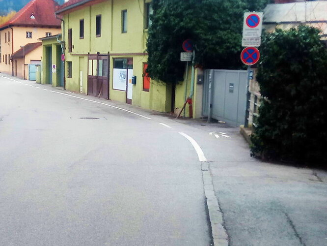
Here picture, where the separation between footway and carriageway changes from kerb to road marking.

For me it is just sidewalks, certainly no shoulders there. Mind you, local law has a definition of sidewalk, and markings are literally allowed as separators.

2 Likes

I agree, there is some confusion. But it is relatively small (and insignificant for data consumers) compared to for example far more problematic OSM use of highway=footway in a way that is contrary to what Footway actually means in English (i.e. in OSM, footway not only does not need kerb/etc separation, but in fact does not need to have nearby carriageway at all). With sidewalk the confusion is at least only partial :person_shrugging: - it seems to me that if OSM is to be used around the world, and not just in one country, that there will be necessarily always be confusion for English speakers (given tags are in mostly in English). There is even often serious confusion between just different dialects of English; now imagine how it must be in much more culturally diverse parts of the world!

I sometimes wonder if it wouldn’t have been better if OSM decided to use wikidata-alike numeric IDs instead of UK English names for tags / values - it often seems to create way more confusion and flamewars than it helps with “intuitively” understanding the meaning :frowning:

That being said, I do not wish to enforce any particular use. I would just plead that whatever people decide to map those “pedestrian lanes” (or whatever one want to call them) that they make sure that:

  • it is documented (as I’ve tried to document in Sidewalks - OpenStreetMap Wiki for this specific issue)
  • open appropriate tickets so routers (and other data consumers) actually make use of such way of mapping

Choose key from that list in link I’ve sent you, click on Values, and type lane and press Enter.

Ummm, I think you might’ve confused me with someone? I’m the one who opened this thread in order to find out how people map it (and replied to you only to clarify something you asked about). I do not intend to promote any way specific of mapping those. I only intend to invest time to document what people say how they are mapping those things, in order so next poor soul that comes along does can see that in short form and decide for themselves quickly, instead of instigating yet another long-winded discussion without consensus. IOW, I only intend to describe how it is being tagged (so interested data consumers can handle it), and not prescribe how it “must” be used.

That is true that it would bring extra details. As you said, it has not been used yet. If you care about it, I suggest to link into other thread by clicking on port reply arrow and choosing Reply as linked topic, and try to describe how it would be used (or even jump straight into https://wiki.openstreetmap.org/wiki/Proposal_process).

Thanks, I’ve not seen that suggested so far, I’ve documented it in the wiki too!

1 Like

I have no problem with using the :lanes-tagging schema but please be careful with the value of lanes=*. Bicycle anf foot lanes do not count!
Two more points to consider:

  • How about horses? Are they allowed on the right lane? I guess not.
  • oneway does not count for pedestrians

I propose:

highway=residential
lanes=1
oneway=yes
access:lanes=yes|no
foot:lanes=|designated
width:lanes=|1

and probably placement=middle_of_1 if the way is drawn in the middle of the vehicle lane.

EDIT: fixed links

1 Like

Thanks! I’ve added a warning to the wiki that while :lanes “extension covers all kinds of lanes for all kind of vehicles and is not restricted to motorized traffic”, lanes=* does not count neither foot nor cycleway lanes.

(also, you links seem to link to wiki.openstreetmap.de instead of wiki.openstreetmap.org, which doesn’t work for me)

They are not defined (not only for the right, but also for the left lane!), so it is unknown. In places where they are an realistic possibility, it should be defined (as might other things like kick_scooter, snowmobile, hand_cart, electric_bicycle which might be region-specific)

It is unclear. See wiki part about “some mappers consider oneway=* valid for all kinds of movement, including foot” and below, as well as Talk:Key:oneway#Pedestrian_oneways

is the first element empty/undefined on purpose? I see it documented for lane maxspeed to be omitted when non-existent, but cycleway lane example (which should be similar to pedestrian lane example for :lanes extension) at Lanes - OpenStreetMap Wiki uses regular no as example for forbidden access

Thanks for pointing out that lanes=* only refers to the lanes with motorized traffic, that was new to me. Your usage of access:lanes=yes|no + foot:lanes=|designated would imply that pedestrians are allowed to walk on both lanes of the road. I’m not Croatian, so I don’t know if that’s correct or not.

I am sorry. Thanks for the hint. I have fixed the links.

I do not know how deeply we want to dive into :lanes-tagging here or if a new topic would be better.
Additionally, I only know the German law well enough to talk about details like horse and which lanes are completely prohibit.

The first sentence is pretty clear in my understanding (only vehicles), https://wiki.openstreetmap.org/wiki/Key:oneway:

The oneway tag is used to indicate the access restriction on highways and other linear features for vehicles as appropriate.

see also:

Yes, I left the values empty as I do not know the rules in Croatia.
Even in Germany, no for bicycles is disputed as there are too many exceptions like turning left on the next intersection, overtaking, or if the lane is blocked. We have use_sidepath as access value but we miss a use_sidelane or similar for access tags per lane, see:

Wouldn’t “shoulder” better than “lane” for an at grade pedestrian strip at the edge of the roadway. They could be used together “shoulder:both:lanes=2” in the case of separate bicycle and pedestrian lane on each side of the road surface.

I’d suggest not - in British English (the dialect that OSM mostly uses) it’s not a shoulder because it’s not wide enough.

Call it verge if you want and add a surface tag, or make up your own term, but picking a word that means something else is likely to confuse.

Personally I’ve always tagged sidewalks separated from the road by paint but not a kerb as sidewalks.

1 Like

Which brings us back to the main question: is a sidewalk an infrastructure that’s separated from the carriageway, or is a sidewalk just “where pedestrians walk, wherever that is”.
My understanding has always been that in OSM, a sidewalk is a dedicated way for pedestrians and/or bicyclists, physically separated from the carriageway, running along of it. But since I’m not a native speaker, so that might be a misunderstanding. I always thought sidewalk = trottoir = Bürgersteig, just for background.

1 Like

That my understanding. It mainly the seperation by some type of barrier.

I wasn’t aware that a shoulder was less than a particular width. Is there a term for an at-grade pedestrian way.

I would suggest one but the US doesn’t have a concept of anything else but shoulders. Other than for emergency use, designated at-grade pedestrians ways don’t really exist. There usually a customary yellow line to marks the outer edge of motorized traffic but I don’t know how much it is enforced.

This because most municipalities either build sidewalks or let pedestrians to walk on the road surface of any residential or low speed street.

I have always thought the tag included ways dedicated for pedestrians but separated from the road only by markings

Probably, look at the picture I posted above, where the sidewalk changes from being separated by a kerb to being separated by a road marking, is it instead turning into a shoulder then?

The more I read about the subject, the more I like the tagging mentioned by @Minh_Nguyen - the pedestrian_lane - which is very much American :slight_smile: This even would lend itself for separate ways tagging, much the same as is done with sidewalks. I miss his vote in the proposal there.

I put the pedestrian_lane in the Wiki section, it got moved from top to bottom, while this is the most convenient way for mappers. The lanes: stuff will never work. I bet, there are lots of such lanes mapped either as sidewalk or as nondescript footway.

After all, the distinction, even if here not based in law, is based in construction standards, for good reasons: Ground markings are not seen in winter, e.g.

Ummm, both of those resolve to the same meaning to me? “infrastructure that’s separated from the carriageway” does not specify how it must be separated (tree lines, jersey barriers, bollards, kerbs, different surface on the same level e.g. paving_stones vs. asphalt, or just painted lines) - just that there should be clear delineation between carriageway (i.e. lanes dedicated for regular motor vehicle traffic) and other surfaces (where regular motor vehicle traffic is not allowed).

Note that we already have the similar “what is required for delineation” with foot vs. bicycle combined ways - i.e. how we tag segregated=yes cycleway and footway – they might often be segregated/delineated by kerbs, or they might be on same level but just different surface, or there might be only painted line (and some pictograms) for delineation.

Depending on the country, some of those demarcations are more popular then others, of course.

I’ve tried to sort them by their current usage according to taginfo where possible, as that at least is (mostly) objective. Trying to sort them by what is preferred would necessarily bring subjective bias into play (and thus needlessly hurt feelings of everyone who does not share that same preference) so I tried to avoid that as much as possible. As taginfo usage changes with time, feel free to rearrange them.

Just north of here there’s somewhere you can walk separated from the road by a painted line. I mapped it from survey (originally as “footway”, later changed to “sidewalk”) about 10 years ago. There’s no Mapillary coverage, but you can see it on GSV here.

I am a native British English speaker** and I’d suggest that the description of this would be a “pavement”, but because that means different things in different versions of English OSM tends to use “sidewalk” for that. It’s not really a shoulder - those are common on motorways and some expressways in England, but not on other roads. In Ireland, going back a few decades, shoulders were extremely common (less so now after more motorways have been built). There are still some examples; here is one that I found without much searching.

** but I am only one of many, and as the StreetComplete shoulder debacle showed there are different view here.

1 Like