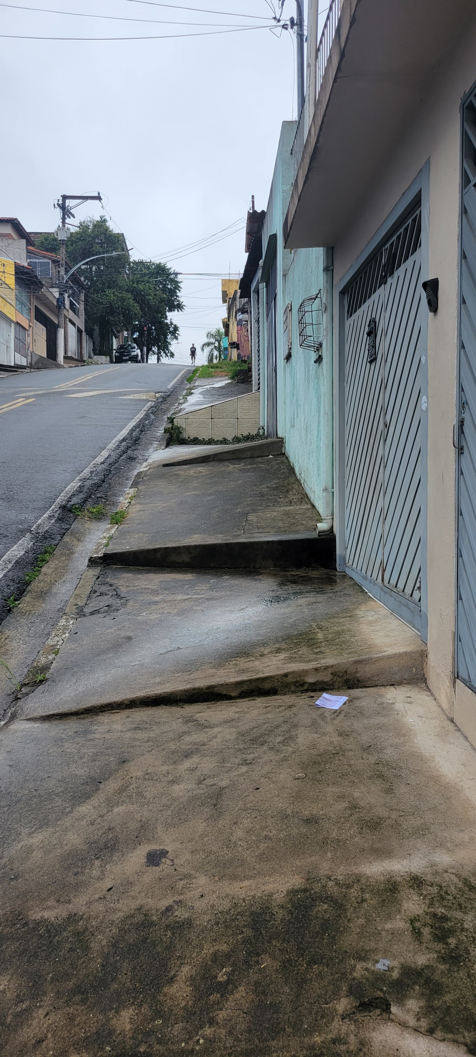
Hello folks. In some countries, but particularly South America I think, on the side of the street there exists a semi-formal space where people can walk to avoid cars, which also forms the periphery of private property with many ramps into the garages of private residences. Most people elect to walk on the street because it is more comfortable, and then walk in this strip of space during moments of heavy traffic which is expected. To my knowledge there is not a good way to represent this with current tags. Would it be useful to introduce an additional sidewalk tag? Or is there a decent way to represent this with a combination of existing tags. Pictures below:

6 Likes
is this public or private space?
Good question!
My initial reaction is at least this ones I would tag as highway=steps if I would be forced to select one of existing tags. But I am not claiming that it would be a good tagging. It does not entirely fits as in many aspects is clearly worse than steps.
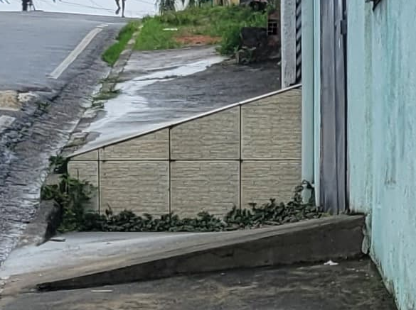
Especially say here which seems to not be passable and requires getting to road.
2 Likes
I am unsure. It is possibly private technically, but no one treats it as such de-facto. People walk here all the time. The residences need the ramps for their cars, but it is not treated strictly as their space.
Maybe the best solution would be using the tag of sidewalk:both = no. I can’t imagine it would it be of any significant benefit to the map to add foot=yes as an additional tag? I think this is clearly implied by the residential classification, but maybe it needs to be explicit so no foreign companies ingesting OSM data gets the idea to restrict it from being a walkable road in their navigation applications?
1 Like
maybe it can be treated as road shoulder? maybe even it is a road shoulder? (road shoulder tagging has bunch of own issues)
It seems like a ramp in front of each shop. Is there a local name for what you are describing?
It’s called “garage ramp”. We have them in Bulgaria as well. Usually they pave it with tiles or concrete. It is possible to walk on it, but if the ramps are “up, down, up, down …” and the denivelation is high, most of that sidewalk becomes unusable. So far I’ve classified such paths as sidewalks if they fulfill the following criteria:
- It’s possible to go around the ramps using a stroller without going on the road
- If it is wide enough (at least 1.5 meters)
- If it’s not too slopped towards the road
The first criteria can be ignored if the difference in the levels between each two ramps is 12 cm or lower
Following these 3 requirements, both photos show sidewalk:side=no
4 Likes
I do not see a sidewalk on these photos: Neither one to map as an attribute of the highway, nor one to map as a separate highway=*, including the possibility of mapping steps there. My personal opinion, these roads are sidewalk=no, on the side pictured. And no shoulders neither, verges perhaps?
3 Likes
Not too my knowledge, My partner who is local only described it as the ‘side of the road’
I think your solution works, but as people prefer very much to walk on the street itself, but frequently deviating to the ramps for safety during busy days or to get out of the sun a little bit, as is accepted by the community, I am in favor of tagging these as “sidewalk:both=no, foot=yes”. When a road is more commercial in nature, maybe I will add hgv=yes. Thank you everyone for your input. I will discuss this with the local community before mapping it in this fashion though.
1 Like
This kind of “sidewalk” is pretty common in big cities in Brazil because cityhalls transfer the maintenance of sidewalks to residents, and urban development standards are not enforced if any.
And yes, it’s a public space.
EDIT: another example Mapillary
I’d map the street as highway=residential + sidewalk=both + sidewalk:both:wheelchair=no + sidewalk:both:smoothness=intermediate down to impassable.
EDIT#2:
If the sidewalk is mapped separately from the street: highway=footway + footway=sidewalk + wheelchair=no + smoothness=intermediate down to impassable.
Reference: Key:sidewalk - OpenStreetMap Wiki
3 Likes
Thank you sir,
This is the answer I needed.
1 Like
I have added some more details in my reply.
A footway is something a stroller can be pushed along. These examples would require you to be very nimble, I wouldn’t trust a grandma with a stroller on this path. At least add nodes with barrier=kerb/retaining_wall/yes on the way.
3 Likes
I agree, when deciding on footway / sidewalk I always imagine typical use case: a young thin mother pushing baby pram with twins inside. Would she be able to safely use it? If yes, then it is highway=footway or sidewalk=yes etc.
If not, then it is not footway, but highway=path + wheelchair=no + sac_scale=demanding_mountain_hiking (and maybe even alpine_hiking if judging by some parts on that picture when usage of hands is required to proceed using that “sidewalk”).
See also somewhat related How to tag *unusable* sidewalks?
1 Like
I’ve seen very similar in Argentina, particularly in Ushuaia on the roads in the grid descending to the waterfront (not the best example). I presume a similar issue exists with respect to maintenance. I saw no point in mapping these.
1 Like
There is nothing in the wiki that talks about downgrading a footway because it is too step. Making it a path doesn’t even imply anything particular about the way’s extreme slope either. Only the sac rating does. Even then nothing else calls out that this way is not within range of what normal path or footway is like.
1 Like
Indeed it does not, and I did not mean to imply steepness is a reason for footway/path distinction.
The wiki however does say that highway=footway is intended “for designated footpaths”. The thing from picture above looks at best as informal footpath to me, not a designated one, and I don’t see signs attempting to mark it as designated.
While it is certainly possible that some, ah, logic-deficient municipality indeed didn’t think it over and officially designated this footpath to be used for all pedestrian city traffic (including elderly people, mothers with prams etc), I find it unlikely (and if true, that is indeed something that should be loudly complained about, as I sincerely doubt that it could be used by vast majority of pedestrians – instead it looks like it could be used only by talented parkour athletes)
Making it a path doesn’t even imply anything particular about the way’s extreme slope either.
Indeed it doesn’t, but I don’t see tagging that fits better then most generic path. (as ideas like highway=demanding_path never materialized beyond the basic ideas – if they did, it might fit even better than more generic highway=path).
Only the sac rating does.
Yes, that (sac_scale) was my point (BTW wheelchair=no and smoothness=impassable mentioned before also fit, but not to repeat too much). Depending on local situation I’m not familiar enough with, informal=yes might fit too.
Even then nothing else calls out that this way is not within range of what normal path or footway is like.
I’m not quite sure I parsed this OK.
But to me, if vast majority of pedestrians is physically unable to use some footpath, than it is not really highway=footway. Especially if it is not officially designated to be used by pedestrians.
highway=path on the other hand has “very broad, non-specific meaning”, and e.g. it might require you to use both feet and hands (see highway=scramble thread linked above), or it might even be unpassable for humans without specialized equipment, or it even may be animals-only. Thus, it fits even for such ways (even if, as you correctly note, by itself it does not say anything about how hard it is to use - thus the all other tags to be added are needed).
Does that better clarify what I meant?
1 Like
I think a sac rating might be overkill. In this situation would suggest infomal=sidewalk as a better tag. It implies that this way is an informal path that sort of functions like a sidewalk. Basically it is a collectively way that could be a sidewalk but is not usable like one.