It looks like you copied the command twice.
Edited original, screenshot.
Found the point that connects North American Atlantic ocean and Pacific ocean watersheds. Seems it’s natural, and a tourist attraction.
I took a look around on the map, and I found an odd patchwork of dense networks near Bremerhaven, Germany on the map of non-artificial waterways: waterwaymap.org / osm.org
Someone tagged all the ditches here as waterway=drain. That’s probably not correct.
Someone tagged all the ditches here as
waterway=drain. That’s probably not correct.
drains are artificial waterways, afaik the distinguishing property is how the banks are made (just dug = ditch, also lined with stones, steel or similar: drain)
Based on how these tend to be used in OSM, that’s not really a hard and fast rule. Different places use drain and ditch in OSM in different ways, but generally speaking drains are larger and more important and ditches less so.
Also, plenty of things that look “just dug” or completely natural might have a clay lining or clay in the banks to control the movement of water.
That definition got a big “whatever” from my side when I first read it. To this day, I don’t understand why would anyone want to distinguish waterways by lining of their banks.
I typically map the countryside of my province, most of which is arable land on former floodplains, and thus laden with irrigation and draining systems. As SomeoneElse indicated, I use the following rules of thumb to distinguish artificial waterways:
- ditch - a small waterway. Usually easy to cross by foot, but not by a vehicle. Typically intermittent (dry in summer), so much that I’m bothered by having
intermittent=yeswith those, since it’s so by definition. - drain - larger waterway. Typically contains water year-round. Hard or impossible to jump over, but not wide/deep enough to support any vessel other than a light kayak. Sometimes named, but always has a
refin the public water management company inventory. - canal - larger still, with water year-round. Supports at least boat-sized vessels. Virtually always has a name and a
ref.
And then, there are hard cases when former river beds and oxbow lakes have been reused as drains or canals (recognizable by curved shapes), or existing rivers and streams re-channelized into man-made structures. I deal with those case-by-case (as a drain, canal, stream or river), and not always consistently.
Perhaps I’m being idiosyncratic, but I believe this or a similar approach is more frequently used worldwide. However, I’m admittedly lazy to investigate and perhaps change the Wiki articles.
Today looked at Amanda’s flow loop thread and waterwaymap.org showed there, so visited the main site and low and behold, working again. The elves did something for W10-64, not booted since patch Tuesday on about the 13th. The odd bit, same worked fine on the Vivaldi browser on Android that syncs tabs and history across with all devices on the file.
Clam back in happy pose.
When I was visting family recently, WaterwayMap.org didn’t work for me either. It looks like their DNS was returning a local only address for r2.dev, which was weird. Maybe something like that affected you too
A drain isn’t just a wide ditch. Drains with lining only serve to drain surface water from A to B, while ditches also interact with groundwater, for example to maintain a certain groundwater level at farmland.
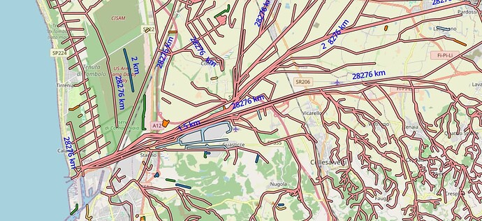
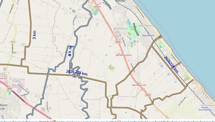
For those who’d like to untangle this, a river entering the sea at Livorno with sum connected waterways of 28,276 km, nr 2 shows 12,560 km and feeds off the same area. (just a short swim looking at 2,626,228 km where the River Rhine enters the North Sea. :o)))
Awesome tool you’ve built! I can’t seem to get the links that should include natural=water in the network to work… Eg. WaterwayMap.org - OSM River Basins does not seem to (automatically) connect the Cogburn Creek as your post indicates… Should I do more than click the link? Or is that feature no longer available?
Thanks!
Sorry about that. I turned off the natural=water connection ~6 months ago. A lot of natural=water in OSM are mapped with relations, which this tool osm-lump-ways doesn’t support. Rather than have something that is broken for half the water areas in OSM. I turned it off. Although in the area you descibe, there are ways with natural=water.
I would like to support that at some point.
That’s not the correct way to map it though – ways with waterway=river should come first, and the surrounding natural=water areas only after that (if ever).
Not sure what is the referent of “that” but I don’t think it would be a good idea.
@Duja and @amapanda_ᚐᚋᚐᚅᚇᚐ , sorry for opening that can of worms ![]()
I chose that particular river simply because it was used as an example in the post first describing the feature.
It seems clear that there are differing opinions on how to best map water flowing through extended bodies of water. For me, having the tool visualize connected water systems for all unambiguous mapping methods would be useful.
I guess the question is whether the tool is for detecting “wrongly” mapped water systems, or for visualizing water systems. Maybe it could even do both ![]()
At one point, I also grouped ways based on natural=water. But my tool osm-lump-ways can’t do relations. So half the examples didn’t work. I turned that feature off.
I like connected waterways. IMO WWMorg should show both, to prevent people “mapping for the waterwaymap” ![]() . (BTW: OSM forum discussion on mapping through .)
. (BTW: OSM forum discussion on mapping through .)
![]()
![]() What do you mean? Do you want something fixed?
What do you mean? Do you want something fixed?
My post last sentence ended in :o))). Think you could not possibly do anything with any of the 3 cited waterway groups, just an open call to the mapping community to figure out where things need separation. The 2626228(km) number shown on the map at Rotterdam also shows up on the map near Rimini suggesting there’s a way across the Alps, maybe around.


