That certainly is a rather odd site when compared to (say) https://hiking.waymarkedtrails.org/. Presumably it’s some sort of curated list of something?
Ah, now I remember… you presented this some time ago on Telegram I think?
The tourism sector indeed needs initiatives like this to make proper use of the OSM information. Things like associating POIs (including hotels, parking lots, restaurants, PT-stops) with routes, trip planning, cutting and exporting sections at will including the POIs), OSM doesn’t do that. Which is fine, because other parties are much better at that, but it could do more to enable it.
I seem to remember that you use a list of trails, which includes selected OSM-relations but also other trails, including non-waymarked routes?
1 Like
So essentially Topics tagged hiking, but in the Communities - OpenStreetMap Community Forum? That would help with discoverability (I’ve forgotten to tag some of my posts hiking), but might be odd if someone wants to have a hiking related discussion for a specific country.
Maybe having a sidebar navigation page that has lists of some common thematic tags along with a sentence or so would allow for granularity. Being able to tag something as “hiking” and “tagging-discussion” is useful.
(apologies; nothing to do with hiking routes, just me commenting on Discourse again)
You can certainly combine categories and tags - https://community.openstreetmap.org/tags/c/communities/pt/176/tomtom is an example of that,
https://meta.discourse.org/t/how-can-i-search-with-multiple-tags/27769/7 suggests that it should be possible to search for multiple tags (and and or), but the functionality is pretty well concealed ![]()
Edit: The advanced search box is sometimes available, sometimes not, but a URL search as https://community.openstreetmap.org/search?q=tagging%20conditional%20tags%3Atagging%2Bconditional will search for two tags together. There’s no automatic link from there to “create a new post with these tags” (which there usually is for categories or just one tag), so the UI’s a bit rubbish though.
The original question of whether we need to create a hiking community on OSM was out of context of hiking routes in and of themselves as well. ![]()
There’s still ambiguity in combining categories and tags. For example - would a theoretical post about trails in Denmark belong in the Denmark category tagged with hiking, or would they be in the Hiking category (tagged with Denmark)? Or if it was about tagging hiking trails, would it belong in the tagging-discussion category with tags of hiking and Denmark. One benefit of just sticking with tags is that less topics would be siloed, though it’s not intuitive or discoverable as things stand.
If there is a community / category just for hiking it’d seem like other communities / categories would also logically spring up because of that (which would have it’s own pros and cons). Perhaps a more general category like “outdoors” or “non paved surfaces” or something would be better, as there’s overlap with climbing, walking in parks, skiing, etc.
I know we’re offtopic now:
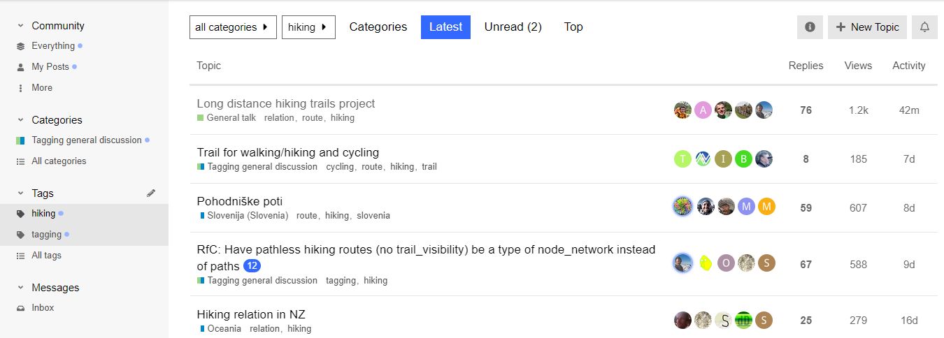
I don’t think such communities (with the need of moderators too) are needed. You can create these on the fly by editing your preferences and select the tags you’re interested in.
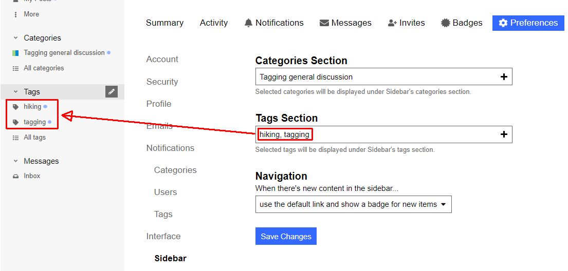
You can then select one of the tags in your sidebar and get the list of topics with the selected tag:
5 Likes
Nice to hear you had use of the data. If I remember correctly I was the first to digitize that path based on a permission by the association that maintains the path ![]()
I have never walked it so it might not be accurate ![]()
Based on my experience the data is we usually have on hiking paths in Sweden is high quality when it exists, but a lot of paths are still missing a relation.
Thanks, I just added this to my mental list of things to discuss in our sub-community: how do we track progress? In France we have figures published by the national hiking federation but it’s not clear how they obtain them and I’ve found that figures produced by each local authority or tourist office are inflated. Anyway, nobody here seems to have spent much time tracking progress so far.
This makes at least a half dozen if topics I’like to raise with you guys. Hopefully you have yours too. But with my current perception of this community Discourse I feel that creating threads would be like throwing pebbles on a beach hoping the right people find them.It is only months after it was created that I discovered this very thread, lost amongst threads in Korean and Dutch, and pointed @pyrog to it. So I believe Davey’s intention was “create the conditions in which we easily detect new topics and can work more efficiently towards consensus or action”
The trick above (setting our application parameters) may be what we need for that. If that is the case we probably need to advertise it (where?). Otherwise we need everything else we can find. Maybe even a report to the site managers to explain our difficulties? Something like “we’re the long trail mapping experts but we keep losing our way”.
Thanks, I’ve added the hiking tag to some recent discussions on related topics. If we all do the same we’ll have a nice overview of relevant discussions on the tag page
2 Likes
I have ![]()
I recently begun opening an issue for every single hiking trail in Sweden that I find in some primary source (municipality or similar website og open data)
The data I find I store in Wikidata, see Wikidata:WikiProject Hiking trails - Wikidata because it is a better platform to keep track of things and it can easily be linked to OSM with the linking tool i recently built
Well, in all honesty I have too. But I have kind of put it off, both because I felt very much alone trying to update information in the wiki, and because I had the feeling that more automated solutions could come from integrated QA & monitoring tools.
After exploring a bit (thanks for the tip!) and noticing that tags are free form, chosen by users (e.g. @pangoSE uses hiking-routes instead of hiking), I’d rather be in favor of the creation of a Community named “Hiking (English spoken)” or “Outdoors (English please)”, which would be both easier to monitor and more easily found by new users.
The machine translation feature integrated into Discourse (the little globe that appears next to the thumbs up button when you’re looking at a foreign language post) works surprisingly well.
If you read some of the recent Korean posts, some of them actually make the point that having separate subforums per language is problematic because it excludes speakers of other languages, and the fact that the general forums are predominantly English speaking means that whatever is discussed there is just accepted as the global consensus without input from people who don’t speak English well enough to feel comfortable posting there.
(At least that’s the point I think they’re making, based on machine translation of the posts, haha)
Wouldn’t it be nice if we could have a discussion about hiking trails where each of us feels free to post in whatever language they want, and still we all understand each other?
This would work even better if thread titles were auto-translated and if we had multilingual tags or multilingual community names.
3 Likes
Yes, I was among the ones who suggested it originally. But as you guessed I’m talking here about topic titles. Browsing a list of titles in various languages to find the ones you may be interested in just defeats the whole idea of subscribing to domains you’re interested in.
And believe me it’s frustrating to feel the responsibility of transmitting ideas from my own linguistic community to this forum and back. Unfortunately, I must accept that even with auto-translation my compatriots do not feel like coming. We’re not there yet. Not far, but not yet.
“Outdoors” would be good - there’s a lot of commonality between working with walking routes and cycling routes, for example.
4 Likes
Outdoors would be a good forum to dispute that statement! ![]()
I am currently working on the E2 hiking route.
Why now?
I got a request by the operator/developer of longdistancepaths.eu to check and improve the route relations. He uses gpx-exports to transport the osm-routes to his site. The challenge is to make sure that the exports are single strand continuous gps-tracks. To do this, you need to make sure there is one continuous route designated as the main route.
Issues
Gaps in the single gpx-track are caused by missing ways, wrong order in relations, roundabouts, variants added as ways with roles, missing connectivity between sub-relations, and the use of complete regional path relations where the E2 only uses part of the regional hiking path.
Ah, and the use of backward and forward roles, which is normal for bicycle relations but useless for hiking relations.
Since the E2 is a complex collection of national, regional and even local hiking trails, and most of those include variants and/or are used only in part, this is not a trivial task. Trying to catch this collection in a single hierarchy of relations is not everybody’s cup of tea.
Tools:
Tools are beginning to pop up, but none (yet) are up to this very complex task. I simply use waymarkedtrails for an overview and to check the hierarchies, sometimes also to check for gaps using the elevation profile. Then I load problematic relations into JOSM (Control Shift O). So far, I had to load each and every relation into JOSM!
Progress
Currently, I fixed the east variant part UK (Scotland and England).
I will continue with the UK west variant to finish the UK part.
Then Nederland, Belgium and France. I have done Nederland and Belgium in the not-so-distant past, and I know these areas and their OSM communities better than the UK or France.
In France, E2=GR5 and I believe much work has been done already by the national OSM community. Some of these mappers are also active on this forum.
I expect to finish this project end of next week.
1 Like
Er, not quite.. I’d suggest checking with people familiar with the on-the-ground situation elsewhere too - the Teesdale Way had some issues before and seems to have some different issues too.
Thanks, I will look into it and correct my mistakes. Looks like the route mapping in the UK has increased since the last time I checked there!
I may have to accept a few gaps where the separate ways do not actually connect. I did use viewers to find the acorns, but failed.
Ground truth is a thing - on the continent we sometimes have a few markers at important points, and in between you have to follow the regional or national markers (or even a local trail). Since these few markers associate the actual path symbol with the E2 symbol, I think that is considered ground truth.
The best page I’m of aware of about the UK part of the E2 was removed from the Ramblers Association website when they upgraded their website about a decade ago, but is available still via this archive org link
At least the Essex Way section and the link path to Harwich International don’t sign the E2 route - my assumption has always been that it is this footpath then Ray Lane, Refinery Road that is the intended route.
Edit: I’ve just found some newer websites about the E2 that show following the Essex Way all the way to Harwich which leaves you nowhere near the International Port (which is near Parkeston). I suspect this mistake crept in after the Ramblers Association removed the details from their site.
1 Like