We just signposted an E route in our little town!
3 Likes
E2, West Route, passes through Belgium. Did some work on that. Still missing the Irish section. In France E2 follows the GR5. I would say E2 is pretty complete.
1 Like
Oh I thought it might be waymarked as they also mention it here: Rondom Berg en Bosch . But could very well not be the case (I will check it)
What E route would you propose @Peter_Elderson ? And how would you approach a pilot project for such a long and complex route?
You are right! It was waymarked back in 2008. Since then no maintenance was done. This organisation has/had a dozen such routes. I have surveyed and mapped one, the Koninklijke Weg. I found many problems with the signage, and contacted them about it. They did not plan any maintenance, hoping that the national operator would take it on, but they didn’t. Nothing whatsoever. E.g. the routes are supposed to be wheelchair-friendly, but in many places road maintenance has been done, making it impossible or very dangerous to pass in a wheelchair. They would e.g. get stuck while crossing a road and finding they cannot cross the kerb on the other side.
So I think it is a good example of bumping against a wall, but not one to set up a mapping project for.
Maybe E1 or E6? Those run North-South and traverse a lot of countries. The mapping is mostly complete in the middle, but less so in the north (Norway, Sweden) and the south (Italy).
I think first thing is to find out which countries are involved and how to contact mappers/teams/communities. Second is assessment of completeness and quality, by the national or regional participants.
While doing that, I think it would be beneficial to inventory what tools are being used by mappers communities, which may benefit other mappers who do not have that.
Same for workflows to map new routes or sections, and maintenance workflows.
Using the satellite image I have been tracing a lot of the hiking trails around West Newbury, Vermont that I have been on. There’s a lot of unmapped area around there and it is also a great opportunity for mappers, especially with these interests.
1 Like
Sounds like an opportunity for hikers with a bodycam. Recording the trail and the things you pass on the way to Mapillary, then co-operate to map it in OSM. Some could map the terrain and the roads/paths, while others fill the route relation as the mapping progresses.
1 Like
Both look fine. Lets start with the E1 then, as a matter of system.
What would be a good platform/place to gather and organise this information? I am not so familiar with the different communication channels of OSM.
We are talking here, that seems fine to me. Anyone can join in.
I think the osm wiki would be the place for an umbrella project / progress / log document. This would then fall under Mapping projects - OpenStreetMap Wiki and would contain links to any country-specific hiking projects, such as Sweden/Hiking trails - OpenStreetMap Wiki
Edit: I have created a project page on the wiki, and added the link tot this page to the mapping projects page. It’s under Recreation… as an example of Hiking.
Just a few sentences on it, feel free to add or edit. Next step would be, I think, to look at the countries involved, and establish contacts (mappers, communities) who can provide more information relevant to this project. Preferably contacts able to add/edit their section on the the wiki project page!
Unless someone has a better idea (you never know…)…
1 Like
Exploring the wiki, I found this project: Europe/Long-distance paths (Project)
Latest edits 2022
Which links to sub-project:
-
European long distance path E1 (Project)
Latest edits: 2015
Seems like E1 was fully mapped; so we’re probaby looking at a quality improvement project and maintenance.
Nobody here mentioned this, so it looks like it’s not a very wel known project. But, the completion statistics are impressive, so they must have been very active back then.
I am not sure how to proceed.
1 Like
Many routes such as this have wiki pages, and they aren’t always very up to date. To call any one of them a “project” implies that more than one person is working on them at any one time and they’re collaborating with each other, which may not be happening. More likely they’re occasionally just noticing that the wiki is out of date and updating it.
True. They use the word “program” somewhere - that’s probably better. Looking at the completion statistics, I would say it has worked very well, and I guess they considered it done and left! Which provides a fine basis for a restart to check and improve. However, is that the pilot we had in mind?
Great work @Peter_Elderson !
I think it is especially a good project to start with then! It gives us a basis of how things have been organised in the past. It seems only 2 European Long Distance Paths have their own wiki, so I guess a future project would be to expand this and have a status for all of them.
It seems that for the Via Alpina there was also collaboration between hikers and mappers, maybe also interesting later on. (ViaAlpina - OpenStreetMap Wiki)
So lets start with quality improvement and maintenance. What do we want to focus on? Is it an idea to put all the relations through the Relation Analyzer (OSM Relation Analyzer) ?
Are European Long Distance Paths generally verifiable on the ground?
I ask because the E8 in Ireland is not. Currently in OSM it is shown as having a section from the end of the Wicklow Way through the suburbs and centre of Dublin, finishing at Dublin Port. This is not waymarked, even as local trails. There are many possible ways of connecting these points - who decides which streets should be part of the route?
Even on the parts that coincide with local waymarked ways, when I used to map in Ireland I had mixed feelings about the E8. It meant that if I wanted to updated a route relation for, say, the East Munster Way, I also had to worry about another (very large) relation for the E8 that I knew nothing about. And from the viewpoint of a map user, it was frustrating that applications prioritise displaying a route that was useless for navigation, above the routes actually visible on the ground.
But I don’t know if these issues are specific to Ireland, or apply to these E routes in other countries.
In the UK, generally not. There are exceptions, though:
2 Likes
If there is really nothing on the ground, no signposts, no boards, no local waymarking, then the route doesn’t belong in OSM.
I am not very strict though. If e.g. a series of villages each has a map/board on the central square showing the E-route to the next village, that is enough on-the-ground verification for me, for routes of this magnitude.
1 Like
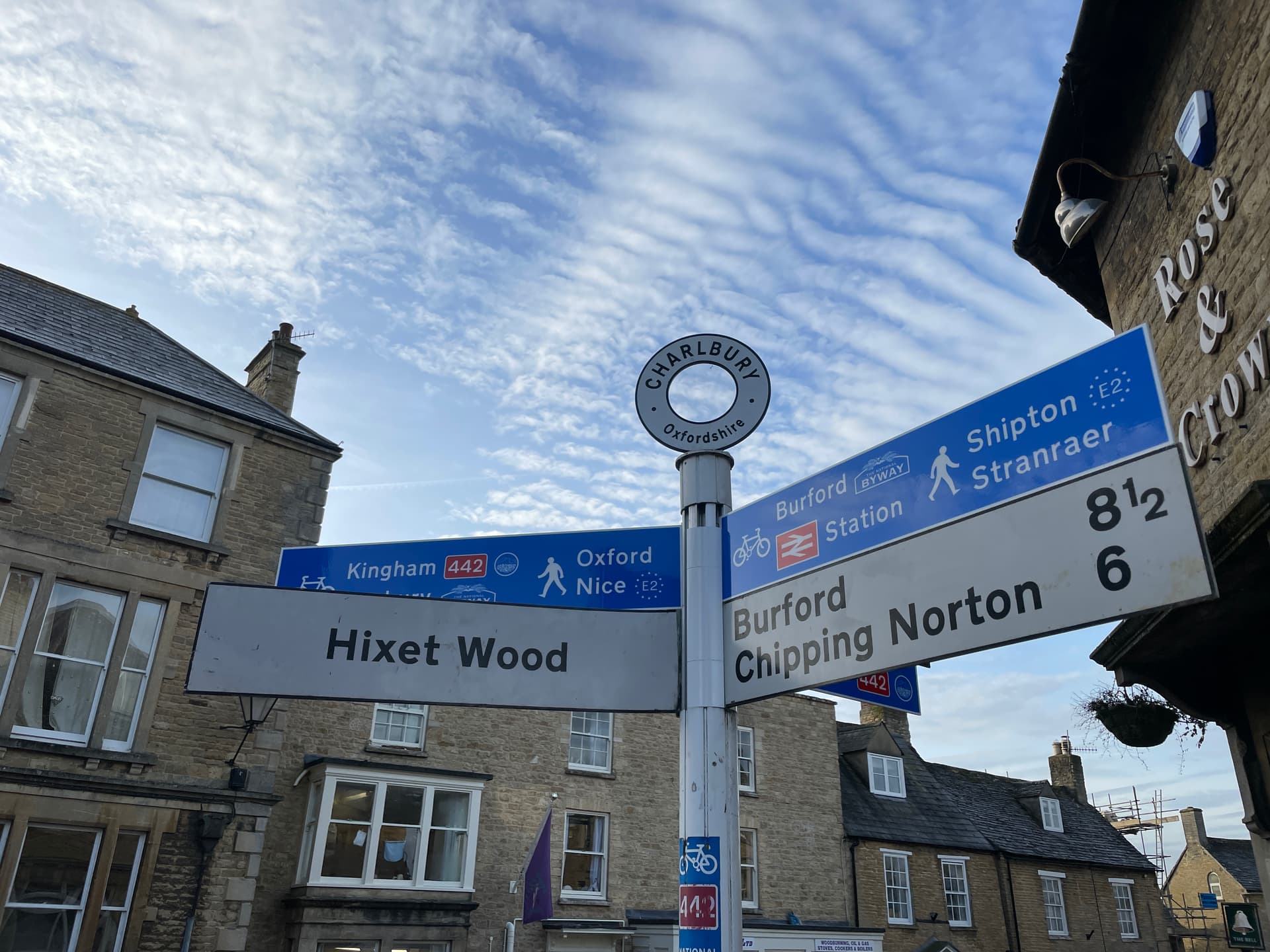
Plus a couple of E2 signs on the UK North Downs Way, apparently.
I’m tempted to be lenient with the E routes because, in the UK at least, they’re made from existing routes which are genuinely waymarked. Through Oxfordshire, for example, the E2 follows the waymarked Oxfordshire Way and Oxford Canal Walk. By the same token, there are relations for the motoring E routes in the UK, even though none of them are signed - they just follow existing motorways. Something like unsigned=yes or signed=partial would perhaps not go amiss.
1 Like
I would not call it unsigned, it’s just that you have to know which local symbol to follow for the E-route. If the association of E-symbol with the local symbol is found on the ground at the beginning of a section, and preferably more points along the route, then it’s fine with me. If it’s purely external information from a web site or a printed guide, or just that everybody knows it, I would not map it, but if someone else maps it I wouldn’t delete it either. I am much stricter about copyright if the info is taken from a different source.
The association of the symbols is recorded in OSM by the local route relation being a member of the E-route relation.
1 Like
Are European Long Distance Paths generally verifiable on the ground?
maybe not all of them, but generally you find signage on the ground (or they wouldn’t be mappable in OpenStreetMap, would they?)
I‘ve seen a lot of Via Francigena signs, and while the Sentiero Italia is not an international path, it definitely is long distance (almost 8000km and currently 588 stages (day tours)) https://sentieroitalia.cai.it/
Unfortunately, it;s a bit more complicated that that. Take E2 as an example here, from Lincolnshire to Durham.
From the Viking Way, you need to cross the Humber Bridge (not actually part of the Viking Way or Wolds Way), then follow the Wolds Way until it joins the Cleveland Way. Then leave that (unsigned) onto the Tees Link. That joins the Teeside Way half way along it.That then joins the Pennine Way, and E2 follows that when it diverges from the Teeside Way again.
Signage? We’ve heard of it ![]()
Maybe we should have a “make reality match OSM” project ![]()
(Signs are cheap!)