Interstates in the southeast not marked as Truck National Network

First off, hgv:national_network=* is a legal access restriction, not purely a route designation or highway classification. That has been a point of confusion in the past.

The hgv:national_network=* key flew under the radar for many years. It first turned up on the talk-us mailing list in 2019, leading to an initial draft of the wiki page. The participants in that discussion weren’t very familiar with the National Network, so the page ended up discouraging the key’s continued use in favor of hgv=designated, even though the key had multiple distinct values.

I discovered the page a couple years later and attempted to rescue it from this consensus with more information. From my perspective, hgv:national_network=* and hgv:state_network=* or something like them are valid and necessary, because hgv=designated is far too simplistic. At least two states distinguish a state network, so evidently hgv=designated is always ambiguous in these states.

For California, this distinction is important, because many roads in the state are physically and legally accessible only to California Legal trucks, not STAA trucks that come in from other states. California doesn’t have a unique sign for the state network, because it’s coextensive with the state route network apart from roads that are part of the national network.

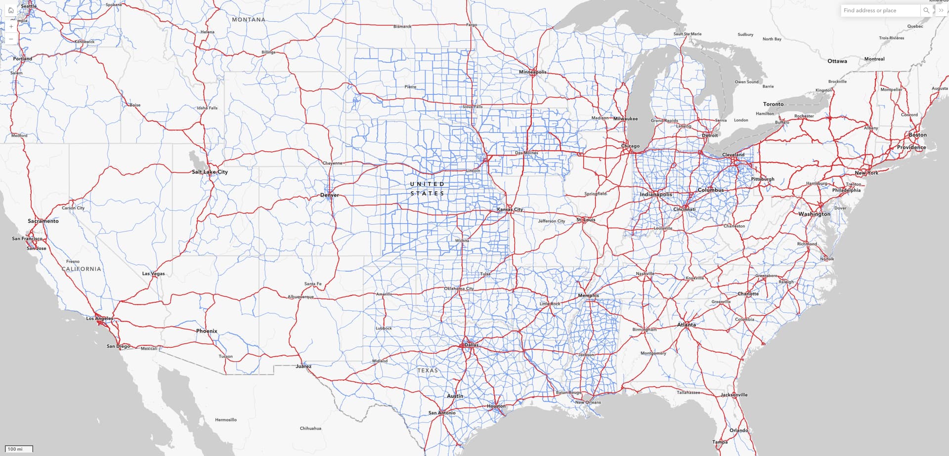
Just as STAA trucks come in multiple configurations, California Legal trucks also come in two different configurations, so these access restrictions are orthogonal to length limits or advisory length limits that the state may or may not post on the same roads. California also happens to be one of the states that measures truck lengths by KPRA; we don’t have any syntax to distinguish the formulas explicitly. If you’re in need of an illustration of “a patchwork of state laws”, behold this map:

Contrary to the speculation on the mailing list, terminal access is not just about funding. For example, in California, terminal access (denoted by a “T”) means an STAA truck is allowed unconditionally, whereas service access (“S”) means an STAA truck can only use the road for a short distance to make a pit stop. Here’s what the signs look like on the ground (with an NEV route making a cameo appearance):

Other states may have similar restrictions even if they don’t signpost them. It isn’t unusual for state and local governments to notify trucking fleets of restrictions primarily through websites, maps, geotargeted CB announcements, and other means that are easier to manage and won’t distract other motorists. Since these tags are about legal restrictions, they’re only useful if they reflect the legal reality. If necessary, we can distinguish between signposted and unsignposted restrictions by other means, such as hgv:signed=* or traffic_sign=*.

In hindsight, hgv:national_network=* and hgv:state_network=* are somewhat unfortunately named, though closer to the mark than other NE2 classics like hgv:minweight=* (equivalent to hgv=no maxweight=*, but the idea is that the tag indicates the minimum weight considered to be a truck). If we were starting over from scratch, maybe something like hgv:national=designated/destination and hgv:regional=designated/discouraged would’ve avoided unflattering comparisons to the network=* tagging scheme. :man_shrugging:

4 Likes

Slightly off-topic, tangential to NEVs: NEVs map plan example exist in California’s Orange County. Not legally the same as a golf-cart (to DMV), must be VIN-registered with the local authority, in conjunction with Orange County and CHP (state police). “The Ranch Plan also requires these low-speed vehicles to be registered through Rancho MMC to obtain an access code to these multi-purpose pathways.” Whew!

Then, you can electric-power zoom around with your spouse, child and maybe tennis gear aboard.

Trucks out on the Interstates and (maybe) certain nearby trunk roads? Not here, not today: those trucks are “elsewhere.” OSM can map where; we can tag these. It seems we largely already do.

Showing where “S” and “T” truck signs are? Well, sweet, and bonus where OSM didn’t have these before. A working “legal” (federal, state, local) “truck network?” Priceless. This can be finished in the SE; we can do this. There’s a minimal set of tags that largely do so in the rest of the network. There are signs that could help. We can map both. Nudge it forward, everybody…we got this.

1 Like

asking why I-40 wasn’t preferred in our truck routing.

If this was a recent question: note that I-40 is still closed to through traffic in NC because of severe damage from Hurricane Helene. Even parallel detours are unsuitable for HGV since they go through national park service roads, etc.

Thank you. We’re aware of that, but the complaint was unrelated.

CS1
CS2
CS3
Southeast interstates should be tagged correctly now.
I added the tags based on “route=US:I” relations and compaired with the Wikipedia Interstate lists, hope I didn’t miss anything.

6 Likes

A serious tip of my hat, sir or ma’am. Nicely done!

I’d be delighted to see a follow-up post by @MarkoŠatrak as to whether anything was missed.

1 Like

@zluuzki thank you!

Indeed, the interstate query with either hgv=designated or hgv:national_network tags no longer shows a gap in the southeast.

1 Like

And to follow up on the topic further, there are (or rather were) still small gaps in the interstates across the country, as visible here:

In our organized editing activity, we will likely assign a part of the team to review the entire Truck National Network, not just interstates. The end goal would be to ensure that the official data (Appendix A to Part 658) is fully and accurately reflected in OSM.
This data is also visualized in the U.S. Department of Transportation, Federal Highway Administration map: National Network Conventional Combination Trucks Map, as shown below (red indicates interstates, and blue represents NHS roads which are part of the Truck National Network).

6 Likes

Just so you’re aware when you eventually get to this, SDDOT has been trying to remove mainline US 14/US 83 through Pierre from all truck routing due to a low bridge just north of downtown, I’ve added hgv=no and re-routed the highway=trunk to that one segment (Way: ‪South Pierre Street‬ (‪1316022705‬) | OpenStreetMap) per that request. I think there’s an official request to re-route the highways and adjust the NHS, but I don’t know how long that will take to percolate through.

2 Likes

@SD_Mapman Understood, thanks.
Speaking as a routing provider, the maxheight=11'3" tag set on that way would have been sufficient for us to avoid that route for trucks.

1 Like

Apparently other routing providers don’t think the same way unfortunately; since COVID there’s been a significant uptick in trucks getting stuck under the bridge so we (I say we loosely, I’m not affiliated with DOT) have been throwing stuff at the wall to see what sticks.

1 Like

I have one more question regarding the Truck National Network, truck tagging in general, and how to possibly prevent potential future deletion of related tags.

Do you think that adding a source:hgv:national_network tag on the ways, quoting the source for the National Network, would help? Similarly, for roads that are truck-designated per state or city and receive an hgv=designated tag, would adding a source:hgv tag on the ways be beneficial? Or do you feel this might be excessive and lead to data overload?

I’ve noticed some use of these tags, as visible in the tag links above.

Of course, general source tags exist as part of the changeset metadata, but I’m not sure how noticeable it would be for a mapper to understand that an hgv tag exists due to a source mentioned in a changeset, especially if buried in the way’s history.

Yes, @NE2 was pretty diligent about adding these tags. Unfortunately, the most common values point to URLs that have been defunct for 15 years. Those URLs are for an electronic copy of an entire part of the U.S. Code, which would be more appropriate for related_law=* than source:*=*. Otherwise, tagging sources on individual features is probably worthwhile in these cases for the reason you mentioned.

2 Likes

Hi @Minh_Nguyen,

Our team has recently bumped into truck routes for CA Legal trucks, example is in this map from West Sacramento.
I recalled you mentioning this topic before, so I wanted to ask for your recommendation on how best to tag these “Local City Truck Routes”.
We could go with just hgv=designated, while the STAA routes tagged additionally with hgv:national_network=yes/terminal_access, but wanted to review it here first.

Thank you!

The National Network documentation calls for the following tags for the entries in that map’s legend:

  • Local City Truck Route (CA Legal): hgv=designated hgv:state_network=yes hgv:national_network=no
  • National Network (STAA): hgv=designated hgv:national_network=yes
  • Terminal Access (STAA): hgv=destination hgv:national_network=terminal_access
  • Local Road: hgv=no
1 Like

I do have another request as you go around and fix the HGV designation in Texas…remove the source as well. I believe we all agree the Sign Guidelines and Applications Manual: Truck Routes link is not the correct source for the HGV routing throughout the state.

1 Like

@txemt, this topic is about the Truck National Network, and I believe you are referring to the discussion here. There may be benefits to keeping that Texas source for the time being, but it is best we continue that discussion in the related thread.

Sign Guidelines and Applications Manual: Truck Routes is a source for cities and towns on how to designate a road as a truck route through their jurisdictions. This link has nothing to do with identifying a road as a truck route throughout the state. There is no map or list that says FM XXX in West Texas is a truck route. It tells Muleshoe, Tx on the steps it needs to go through to designate Main St as a truck out.

That’s why I’m asking for it to be removed.

1 Like

@txemt, I’ve replied here in the original thread that discusses the TxDOT source, so the full context is in one place.