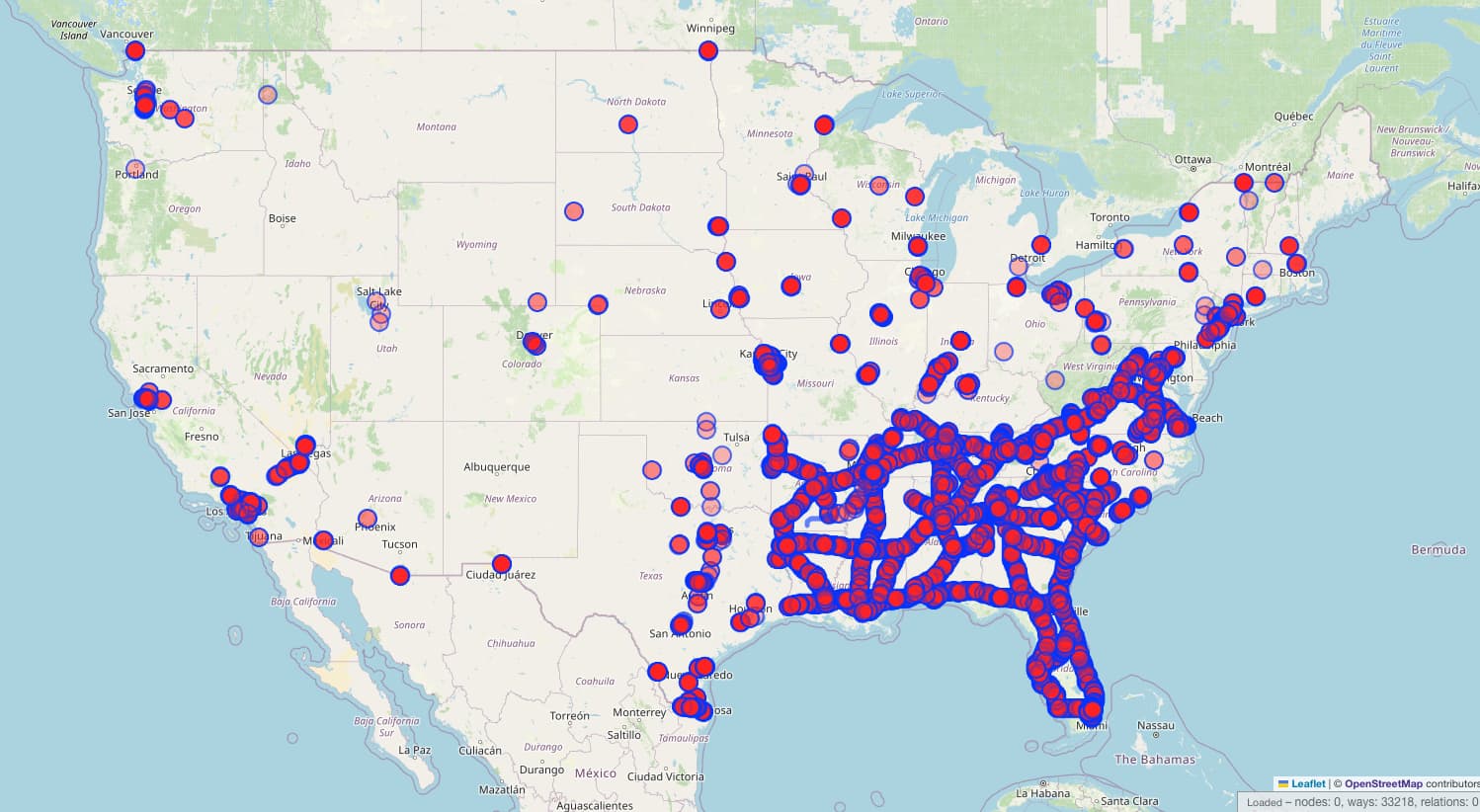
Through our organized editing activity, we have identified an issue with the National Network tagging. Interstate roads across much of the southeastern United States are not tagged with hgv=designated, hgv:national_network=yes, or hgv:national_network=terminal_access, as evident from these Overpass Turbo query results:
[out:json][timeout:60];

// Find all relations with network=US:I in the current bounding box
relation["network"="US:I"]({{bbox}})->.us_interstates;

// Find all ways that are members of those relations and meet the filtering conditions
way(r.us_interstates)["hgv"!="designated"]["hgv:national_network"!~"^(yes|terminal_access)$"]({{bbox}})->.filtered_ways;

// Show only the filtered ways
.filtered_ways out geom;
The Truck National Network is very important for long-haul commercial truck routing, as it ensures compliance with federally designated routes for larger vehicles.
Thanks. How will you identify the sections of the interstate network that are not part of the truck network? It sounds like there are a few exceptions.
Exceptions are very rare, and all are listed here: Appendix A to Part 658. Important: this list includes non-interstates that are part of the National Network (comprising about 99% of the list), as well as exclusions for certain interstates (these are very rare and limited to only a few states).
Looking at the big picture, we’re not sure why approximately 30,000 ways weren’t already mapped, while all other interstates were. It seems consistently not applied in the southeast, which is puzzling.
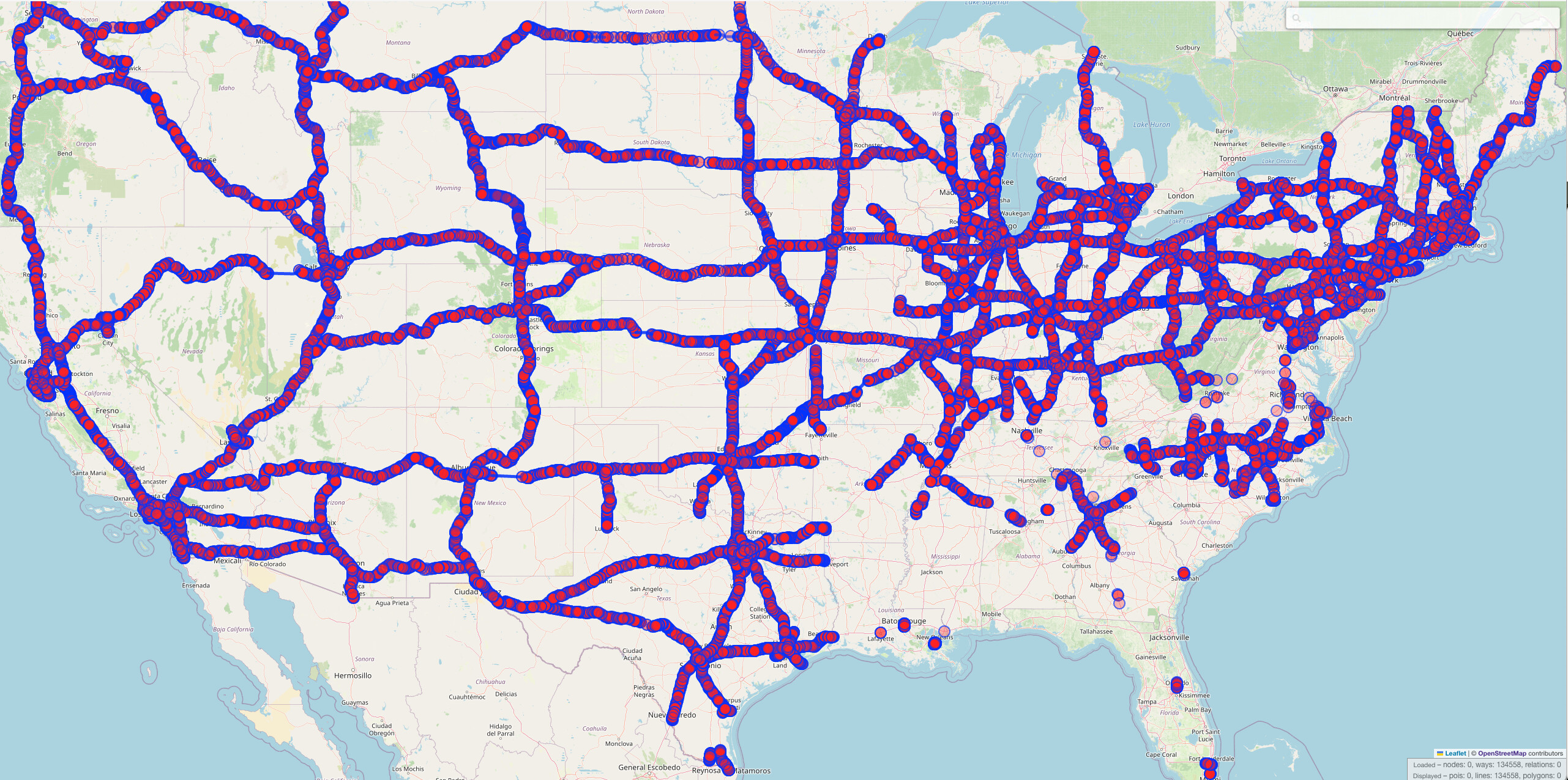
To draw a contrasting picture, here are all interstate OSM ways that are tagged as hgv=designated, hgv:national_network=yes, or hgv:national_network=terminal_access. The southeast is noticeably missing.
Thanks. As long as you’re careful about the exceptions, this sounds fine.
I’ll answer this question - it’s not puzzling at all. These weren’t mapped because data consumers aren’t using it. There’s plenty of other tagging that can be used for truck routers, and the national designation just doesn’t matter much in real world usage. Hence my curiousity as to why someone suddenly cares
Further, to the point of your map, highway=motorway would be interpreted by any data consumer to be appropriate for trucks, hence why the hgv tagging is not all that important. But by all means, let’s complete the tagging.
I would argue that assuming all data consumers interpret highway=motorway as appropriate for trucks is not entirely accurate. I know of at least one data consumer that doesn’t.
Additionally, stating that all highway=motorway is truck-appropriate isn’t true globally, nor is it true for the U.S. For example, consider Kansas KS 96. While it is part of the NHS, it is not included in the Truck National Network.
It might be worth opening a discussion on one of those changesets to see if there was a reason the tagging was removed. Based on the changeset descriptions, the user may have thought it was cruft that no one was using. But I think you’d be well within your rights to just go ahead and re-add the tags without commenting on the changeset too.
If you intend to bulk add these tags, I would personally prefer using the more specific hgv:national_network=yes rather than (or at least in addition to) the vague hgv=designated. Clearly I’m not alone in assuming that hgv=yes would be a reasonable default assumption for highway=motorway, and combined with the lack of signage on the ground for the Truck National Network as far as I can tell, I can understand why someone would see hgv=designated on an interstate, think it was unnecessary, and delete it.
Well, somebody just going ahead and deleting tags without thoroughly inspecting what their purpose is, is… unfortunate. hgv=designated is well-documented on the OSM Wiki:
• Key:hgv
• Tag:access=designated
This tag represents a truck route in the U.S.
hgv=yes is actually the default if not designated, according to the Tag:hgv=yes page.
The OSM Wiki on hgv=national_network, under the “How to map” section, also explains that these routes should be tagged with both hgv=designated and hgv:national_network=yes.
Hello, some time ago I researched & tagged the opening year on various southeast roads. Along with doing that, I removed some tags which I considered to be implied by highway=motorway, such as foot=no, horse=no, etc. and also hgv=designated.
I did not remove any “Key:hgv:national_network” tags - the roads which now lack HGV tags had only “hgv=designated”.
I don’t quite understand why “hgv=designated” implies “HGV national network”, as I am sure that there are many e.g. “hgv=designated” service roads which aren’t part of some national network?
I just looked at various Interstates all across the country and none had the “hgv:national_network” as described in the wiki.
But whatever, this can easily be re-added using JOSM if nessescary - but then probably “hgv:national_network” instead of “hgv=designated” (or both; I have no clue about truck networks).
Let me try to summarize based on OSM Wiki pages and what we’ve observed from querying data across the U.S.:
The HGV/Truck National Network (NN) consists of interstates and other highways/motorways, but not all motorways are part of the NN. That’s why a dedicated tag, hgv:national_network=yes, exists to clearly identify NN roads.
Beyond the NN, there are also other local truck routes that are tagged with hgv=designated. These don’t have the national network tag, obviously.
We actually avoid bulk edits in our organized activity. Since you’re familiar with this type of action, would it be possible for you to perform a bulk edit of the southeast interstates? Specifically, adding both hgv:national_network=yes and hgv=designated tags. This would align with the recommended mapping approach and the vast majority of existing mapping.
Here is the official list mentioning interstate exclusions for each state, noted at the end of each state’s entry after the list of state highways included in the National Network: Appendix A to Part 658.
The only exclusion mentions for the southeast interstates (depending on which exact states you consider part of the region) are as follows:
District of Columbia: I-66—There is a 24 hour total truck ban on the Theodore Roosevelt Memorial Bridge and its approaches.
Georgia: Atlanta area—Interstate highways within the I-285 beltway are not available to through trucks with more than 6 wheels because of construction.
Maryland: I-895 Baltimore—Widths over 96 inches and tandem trailers may be prohibited on the Harbor Tunnel Thruway because of construction.
Virginia: Note 1: I-66 Washington, DC, area—There is a 24-hour total truck ban on I-66 from I-495 Capital Beltway to the District of Columbia. (Excepted under 23 CFR 658.11(f)).
Note 2: I-264 Norfolk—Truck widths are limited to 96 inches for the westbound tube of the Elizabeth River Downtown Tunnel from Norfolk to Portsmouth because of clearance deficiencies.
I’ve at least a couple things to say here, largely at the 30,000 foot level, not down at a detailed level of “right down on the tarmac.”
Let’s be careful with statements like “I’ve lived here my whole life and don’t know about that” (or haven’t seen signs), or “what is the point?” The real world is a rich place, full of subtle, nuanced things not apparent to everybody. Part of what makes OSM such a rich and fruitful database is that it can (and often does) accommodate these things. Sure, there may be discussion and debate on whether something seemingly esoteric belongs in our map, but if it is a “real thing,” able to be pointed out in active legislation / statute (for example, a Truck National Network), I find those data suitable to include in a map whose middle name is Street. Others can disagree, though consensus eventually emerges.
User NE2 was a notorious, abrasive (over a decade ago he swore at me and insulted my perfectly reasonable edits) former OSM Contributor who was rightly asked to leave the project; he has not returned. His edits, extensive and far reaching, especially spanning the southeast, continue to persist in our data. They often confuse and misrepresent reality, I speak from first-hand experience. I don’t wish to offer a blanket statement to ignore all his edits, but many can be considered either questionable or downright suspect. He often self-styled himself as a “clever tagger,” when in fact he was simply outright wrong.
I’m not surprised that it has taken 15+ years to uncover that 20%+ of the country’s Interstates are poorly tagged in this regard. I am encouraged that someone (@MarkoŠatrak and friends) is / are improving this — it is a task that obviously someone cares enough to improve, and not only with his / their particular use-case benefit, OSM (via our data improving) enjoys the “rising tide that lifts all boats” as well. This is a basic tenet of our project: what you or I or she improves benefits the wider community, not “only” or “simply” me or a few. We share our map fabric with everybody, even as we sharpen it up for “our own” needs and use-cases. For any and every OSM edit you make, you have no idea how many it will benefit in the future. So “sign your name to your edits” with pride (and accuracy!)
It seems “worth it” to (further) discuss whether hgv=designated simply-tagged implies this specific network, or whether different tagging may be appropriate to specifically denote this network. The former seems OK, but does appear to suffer from the possibility it is deleted inadvertently as superfluous, that’s a shame when it happens, but apparently it does. The latter seems overkill, but explicit denotation is sometimes required to “make the point” (and allow non-ambiguous parsing). This is a fundamental struggle in OSM, it is solved by good discussion, consensus, documenting (as in wiki), diligence in correct mapping and continuing maintenance of the data to support this exact toolchain (of data meaning something, being able to be parsed as such, and staying both correct and relevant).
If several long-time editors have not even heard of a designation that applies to the road network, then that is useful local knowledge worth documenting regarding the relative obscurity of the designation. Especially so given the extensive efforts in the US regarding highway classification! Someone that finds this thread later seeing information about the tag will now be better informed about the character of the truck network designation. If others have other experience with truck networks, then that is useful data also.
I have asked what the point is of this tag and I find @MarkoŠatrak’s description to be reasonable.
I would suggest that “official truck network” and “OSM hgv tagging” are likely different though perhaps often-overlapping concepts. With the former being a government designation and the latter being a legal access restriction.
What I think is up for debate here is whether the federal (on paper, perhaps unsigned) designation meets the definition of hgv=designated or whether that latter tag should only be applied where truck access is explicitly signed. I don’t think that part has been adequately explored here.
We are a routing provider. This topic came to our attention following a complaint from one of our customers in southern Tennessee, asking why I-40 wasn’t preferred in our truck routing. As I investigated, it became clear that the issue extended further south, revealing an even bigger problem. As stated earlier, relying solely on highway=motorway as a rule for truck preference is simply not accurate—both in the U.S. and worldwide.
Truck routes, or even truck restrictions (such as no trucks or weight limits in certain areas), don’t always require mandatory road signs to be in effect. Some city codes of ordinances specify that an erected sign is necessary for the rule to apply, while others do not. In some places, truckers are expected to be aware of brochures or other materials that provide guidance on what is legal in that area.
Like @ZeLonewolf and @SD_Mapman im here in Valdosta GA and never seen a sign for this but if there’s a standard that would be useful to update 75 with I don’t think I have an issue with it.