I’d probably do it with naturalearthdata.com which has country
boundaries and land mass. Easy to hack something up, even loading the
boundaries as GeoJSON into Leaflet or so.
(In addition to Grame’s comment about this being a rabbit hole, a lot of
discussion has been had in OSM about the question of how to represent
“country X’s view of this boundary as opposed to that of country Y”…
Okay, first to the question of disputed territories, and what level of boundaries to show at what zoom levels. These are all not any problems, because one could simply show the same thing that the Carto style layer will do… Just with thicker boundaries, that’s all.
https://osm-boundaries.com/Map looks very promising, except one, it doesn’t work on a cell phone pleasantly. Two, it’s either all or nothing: you can choose the plain boundaries layer, or you can choose the Open street map layer, but you can’t combine the two to get the heavier boundary effect.
Political maps are a sensitive topic.
Usually those maps are produced at small scale, like 1M or so, to avoid political issues.
BTW, have you checked on the United Nations geoportal if any public map could fit your needs? https://geoportal.un.org
Thanks, but even loading that website is tough for my browser.
Anyway perhaps people replying to this thread could all used the same
California sample area as I did above, giving a link to what their solution looks like vs. mine.
(somewhat away from the original request, but still worth mentioning I think)
Unfortunately, the inclusion of Gibraltar on a list of “Non-Self Governing Territories” there, and the exclusion of the Chagos Islands from that list doesn’t reflect well on the veracity of the rest.
What it does help demonstrate is that all maps have a point of view - in a sense all maps are political. You can show “who controls what” or “who claims what”, but there is no superior independent authority, only various lists of countries and other organisations that support particular views. The UN is one of those lists, an important one, sure - but not the only one, and certainly not the arbiter of truth in all cases.
That’s a really good example of the political shenanigans that can result in large international organisations (such as the UN) pretending that certain places “aren’t really countries”.
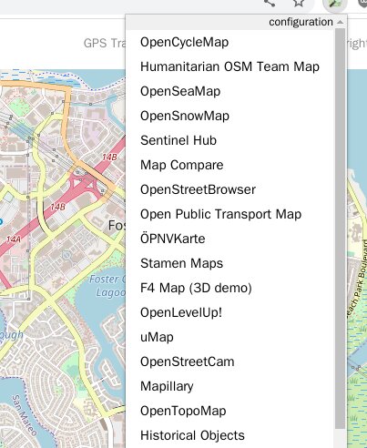
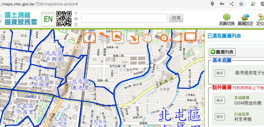
So you’re probably asking, “Dan, it looks marvelous! How did they do that?”
Well, all they did was have, village, city, and county boundary layers available in their layer selection menu. (Hold on, there’s a big EN button. Maybe I can make the same map in English. One moment please… Nope, they don’t even have half as many layers in their English version, so never mind.)
So all that is left is how to put this right into https://www.openstreetmap.org/ !
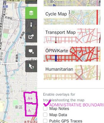
Well, here we go!:
Yup, right in the Layers menu, under “Enable overlays for troubleshooting the map”,
there would be a new [x] Administrative boundaries checkbox! Yeah, I know, now you’re saying, “Well there are village, city, county, etc. boundaries. How are you going to deal with that? See, your plan is falling flat on its face.”
To that I answer: a new pair of “A+” and “A-” buttons would appear on the edge, so the user could quickly switch from admim_level=…6, 7, 8, 9…, without even having to open up the Layers panel each time!
Sure, now you’re saying “It says ‘for troubleshooting the map.’ I don’t think you are troubleshooting the map. I think you just had “trouble” “shooting” your holiday snaps when you couldn’t tell your friends if you took them in Frostbite Falls or neighboring Fergus Falls, because the boundary waved all around the map.” OK, well shoot me.
As mush as like and use Id, editing administrative boundaries would be unworkable. The limited zoom in which editing is allowed is too small for most use cases. It would require a bit of work to add what your proposing without much benefit. You may try pitch the idea to Rapid. They found a way to solve restricted edit zoom by switching to a different render.
Editing? I’m not talking about editing.
I’m talking about browsing. I want to see clearly where boundaries are. That’s all.
“Openstreetmap, with boundaries that make sense, without needing glasses”
The above screenshot that I marked in magenta is for https://www.openstreetmap.org/, not https://www.openstreetmap.org/edit.