I feel like the tag highway=busway needs to be better defined. It’s original justification is for the increasing deployment of BRTs but the way the page is currently written first implies a specific use for BRTs but is written fairly general otherwise, reflecting all other types of bus-only roads regardless whether they’re classified as BRT or not. Even other pages (most notably highway=bus_guideway which is one of the main inspirations for the creation of highway=busway) don’t mention BRTs.
The original rationale is that is that separated bus lanes aren’t truly service roads because they don’t access anything but rather are a type of throughfare. However, the main focus is on BRTs whereas other forms of protected bus lanes (which e.g. split a carriageway into two) aren’t well described with exception of bus bypass lanes and bus bays (especially the latter makes sense to me).
Part of it is explained that the tag is intentionally vague but it’s also a problem when applied to busways which largely fit the exception except that it they aren’t (officially) BRTs.
Furthermore (which also bugs me) is that (from the names alone), highway=busway is to busway=* what highway=cycleway is to cycleway=*, especially because highway=cycleway is commonly used for protected cycle lanes.
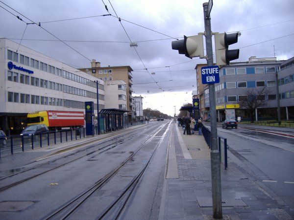
One example I’m very familiar with (to the point where I initially wanted to implent it on my side) is the Rheinstraße in Darmstadt which incidentally is used as the first example of tagging highways in urban areas (which btw should also be updated both in terms of Mapnik display and tagging, both because the information is outdated and because of the busway):
Here, the highway is a dual carriageway split by a tram-/busway. It is not, however, considered a BRT nor being licensed as such (in part for lasting only one and a half kilometre). It nonetheless fits the description of “maintain a high level of importance specifically for bus passengers” in that it allows busses to bypass the car traffic on the Rheinstraße while also being kerb protected. It also isn’t a protected bypass lane like the Piccadilly Circus example because it lasts for a longer distance, essentially for the entire length of the Rheinstraße east of the bridge up to Luisenplatz (which is more of a transit mall and thus unsuited for highway=busway).
Personally I believe trying to limit highway=busway based on a vague criterion such as “it’s part of a BRT” (?) or “it maintains a level of importance for bus passengers” has been a mistake. Such criteria are impossible to apply consistently. To compare, we also mark all bike paths with highway=cycleway, regardless of whether they are a back alley used once per day by some random cyclist, or a cycle highway. (The difference between these can and should be expressed with other tags, IMO.)
For me, any separated roads/lanes that are meant specifically for bus passenger traffic, are highway=busway.
The fact that your example also includes tram rails slightly complicates things but, but in my opinion this is still undoubtedly a highway=busway.
Yeah we’ve all been following that busway osm-carto thread with .
The reality is there’s one maintainer left on osm-carto and he doesn’t like it and will just talk in circles around any attempts at real collaboration.
Osm-carto is a dead render project that’s just waiting for the minutely vector stuff to be good enough to replace it.
I don’t think the OP was really trying to discuss the busway rendering in osm-carto here. I believe it would be more productive to keep the flames from that discussion where they belong, in the respective thread, and try to just discuss the semantics of highway=busway here.
Highway=busway was meant to be used for BRT only, however it turns out that is can be hard to know what is and is not BRT and where a BRT start and stops.
Currently in the Nederlands highway=busway is applied on all bus exclusieve roads. Including short sections and bus terminals.
We see a massive flame, as you put it, yet again trying to hopelessly push through busways on osm-carto, and the maintainer says “go fix osm”. And now we see this thread about busway tagging.
Perhaps the way people are using the busway tag is perfectly fine, and we shouldn’t be trying to modify tagging practices to please a single osm-carto maintainer that simply cannot be pleased.
Willem is correct, though the rendering is a problem, it’s ultimately a separate one and my main concern was never the rendering itself but rather its use for non-BRTs (for this reason, I marked both of your replies as thumb down not as “I disagree with you” but rather as “You’re off-topic, it doesn’t contribute to the question”).
I’m all for the meaning of highway=busway expanding beyond BRT roads to include other dedicated bus roads. I don’t think it should be for every bus only road though. Short pieces of road in and around bus terminals and depos already fit the meaning of highway=service as they are for access to buildings. I don’t think it makes sense for these to be highway=busway. Any other road that would be highway=residential or a higher classification if it were for regular vehicles seems fair game for highway=busway though.
I don’t have a view on where it “should” be used, but where I was interested in usage it seemed to be on short “service” road stretches, annd at the end of guided busways. - there are relatively few BRT schemes in the UK or IE.
Regarding your specific example, I’d fairly confidently call it highway=busway: the bus/tram only-lanes appear to go on for a significant distance separated from traffic (maybe Germany has stricter definitions, but in the US, a city would probably proudly call 1.5 km of dedicated lane like this “BRT” ).
Perusing overpass though, and as commenters here have noted, I think your broader point that the wiki does not accurately describe current usage of highway=busway on non-BRTs is true. In the US, it seemed like most usage is on ways that are at least close to “BRTs”: bus-only roads that go on for a while separated from traffic, and have at least some sort of special amenities. But in other areas, especially the Netherlands and Belgium, it is used on even the most insignificant bus bypasses, as well as at terminals, in addition to on longer bus-only roads. This usage quite specifically contradicts the documentation, especially Tag:highway=busway - OpenStreetMap Wiki.
My personal view would be that all four of these would be better tagged as some sort of link or service road with access restrictions: they aren’t really comparable to BRT-like systems. I’m wary of making an arbitrary length threshold or something, but maybe a busway has to go through an intersection with a non-busway or something could be a good rule of thumb? But, if people would like to keep tagging such short service ways as highway=busway, it needs to be better documented on the wiki, which currently explicitly recommends against such usage.
I feel like that’s part of the novelity of the tag as well as taggers not understanding on what it’s supposed to be intended for. Germany isn’t all much better and highway=busway tends to be used also for minor stuff (though I wanted to improve it upon as evident by this thread).
One notable exception is the ÖPNV-Trasse in Oberhausen but that’s an actual BRT line (even mostly grade-separated) even if it isn’t known as such.
I fundamentally object to characterizing the community in this way. Mappers in various places have considered their options and chosen to use the tag in certain ways. We should respect those choices as valid ones and not dictate to anyone how something “should” be tagged or say that they “don’t understand” how to tag.
The fact that there was a proposal associated with the tag doesn’t change this. Proposals document consensus as it exists at the time. Consensus can and does change over time. If mappers have organically come to use the busway tag (or any tag) in certain ways, it’s not for you or me to tell them that they’re tagging in the wrong way.
It’s actually part of the reason why I created this thread in that it covers figuring out the best practices for highway=busway.
Considering how uncommon BRTs are in Germany (besides the aforementioned Obershausen example, there also is the guided busway in Essen and the infamous Metrobus 5 in Hamburg as at least partial examples), I don’t think BRT is properly defined in Germany and any resembling example is more the result of the occasional best practices and sometimes by taking advantage of tram infra (as the aforementioned Rheinstraße is).
For me personally, I think we should introduce something like service=bus_bay. It’s a very rare tag but but given the “misuse” of highway=busway for such bus bays, there clearly is demand for them (not to mention it is the tag-counterpart of bus_bay=*) and should be turned into an official tag.
Just an observation: it seems like wherever a highway classification technically represents a distinction that rarely exists in a country or region, local mappers have a tendency to fill in that gap with the nearest concept intuitively, perhaps out of a sense that the extraneous tags help to establish a deeper visual hierarchy on a rendered map.
Over the years, this has helped to explain the persistence – rightly or wrongly – of highway=living_street in countries that officially don’t have pedestrian-priority, motorable streets; highway=unclassified as a step above highway=residential where the abutter-based definition seems artificial; motorroad=yes where blue “same traffic rules as a motorway” signs are unheard of; highway=cycleway where bike-hike paths tend to be called bike trails colloquially; and bicycle_road=yes or cyclestreet=yes for “bike boulevards”. (If the proposal for highway=golf_cart_path ever goes anywhere, we might see the golf course mappers blanket surrounding residential streets with it, as they have golf=cartpath, because the golf carts matter a whole lot more than the residents from their perspective.)
A data consumer may find it trickier to support a skunked tag if it wants to completely stay out of tagging debates. The competing visions for highway=busway would prevent some renderers from applying a simple heuristic for which zoom levels at which to show or hide busways while maintaining balance with the rest of the road network.
As a stopgap, many renderers have chosen a “lowest common denominator” of showing them at the same zoom levels as major service roads. Even though it might not be ideal in places with more prominent BRT systems, they’ve made a tradeoff that avoiding conspicuous gaps in the map is more important than exacerbating any skunking. After all, the de facto usage of highway=busway is certainly less ambiguous than any individual occurrence of highway=road, a tag that even openstreetmap-carto sees fit to render in some fashion.
I fundamentally object to characterizing the community in this way. Mappers in various places have considered their options and chosen to use the tag in certain ways. We should respect those choices as valid ones and not dictate to anyone how something “should” be tagged or say that they “don’t understand” how to tag.
I get what you’re saying here, and it’s a valuable point that the wiki should generally be “descriptive” rather than “prescriptive”, regardless of what might’ve been in a proposal at any time. Maybe I’ll try phrasing my point from a different perspective. A couple of mappers in this thread, including @Tjuro and I think @Willem1, have expressed the view that highway=busway is for any road that is exclusive to buses, including very short segments. This seems to represent the prevailing mapped consensus in their local area, the Netherlands, but not in some other regions, such as mine, the United States, and is contrary to how the tag is currently described in the wiki. We certainly can, and probably should, change the documentation to reflect that the tag has significantly different usage in different regions. But I think it would be most helpful for me, and perhaps others, if they could clarify why they think this is a good method to tag these sorts of ways as highway=busway instead of highway=service + access tags, as is currently documented. That will inform in what way to change the documentation: to reflect an emerging worldwide consensus about defining the tag in a broader way, or a place-to-place “agree-to-disagree” approach in which the tag implies slightly different things in different regions.
I think that’s a fair question, and it’s also fair to ask what exactly is wrong with the Dutch approach beyond the fact that it disagrees with the wiki.
I don’t have a view on where it “should” be used, but where I was
interested in usage it seemed to be on short “service” road
stretches, annd at the end of guided busways. - there are relatively
few BRT schemes in the UK or IE.
Experienced one in Swansea, or is it just a road with access
restrictions?
I’m actually not so sure what to do with these very short segments like this one you posted above. I currently gravitate towards applying highway=busway for them too, just because if you don’t, it becomes hard to draw the line.
However, if the community moves towards a rule that says “highway=busway should not be applied to bus bays that serve just a single stop” or something like that, I’d have no problem with that either. My opinion is flexible in this regard
(As noted, the Dutch majority opinion currently seems to be that it’s best to use highway=busway for everything, so I follow that in my local mapping.)