In this topic it was noticed the default access rights for the different language versions of Tag:barrier=bollard are not in line with each other.
Details for language Wiki's
| access=no | foot=yes | bicycle=yes | mofa=yes | moped=yes | horse=yes | |
|---|---|---|---|---|---|---|
| English | 2008-10-21 | 2008-10-21 | 2008-10-21 | 2023-05-04 | 2023-05-04 | 2023-12-29 |
| Français (FR) | 2010-04-22 | 2010-04-22 | 2010-04-22 | 2023-05-26 | 2023-05-26 | |
| Deutsch (DE) | 2010-12-27 | 2010-12-27 | 2010-12-27 | 2024-02-06 | 2024-02-06 | 2024-02-06 |
| русский (RU) | 2011-03-06 | 2011-03-06 | 2011-03-06 | 2023-10-04 | 2023-10-04 | |
| 日本語 (JA) | 2011-03-28 | 2011-03-28 | 2011-03-28 | |||
| Nederlands (NL) | 2011-11-02 | 2011-11-02 | 2011-11-02 | 2023-05-07 | 2023-05-07 | |
| Polski (PL) | 2012-11-21 | 2012-11-21 | 2012-11-21 | |||
| Čeština (CS) | 2016-03-07 | 2016-03-07 | 2016-03-07 | |||
| Español (ES) | 2016-08-07 | 2016-08-07 | 2016-08-07 | |||
| Português (PT) | 2017-12-26 | 2017-12-26 | 2017-12-26 | 2023-07-07 | 2023-07-07 | |
| Italiano (IT) | 2018-09-24 | 2018-09-24 | 2018-09-24 | |||
| Magyar (HU) | 2019-01-23 | 2019-01-23 | 2019-01-23 |
I am thinking of creating a new Wiki template and use it for all language that has “implies” already filled in so that it will be and stay consistent over all languages.
mofa/moped=yes is a more recent addition triggered by this topic but for me at least also logical, a moped/mofa is the same width as a bicycle, what is disputable are motorcyle and horse altough “horse=yes” has been recently added on the German page.
horse/motorcycle in combination with barrier=bollard are ~65% mapped as yes.
Details for access tags in combination with barrier=bollard
628416 bollards
foot          : yes=173435 (98.2%), designated=1362, no=1274, permissive=276, other=255
bicycle       : yes=150778 (94.6%), no=6699, designated=962, dismount=535, other=474
motor_vehicle :   no=36462 (88.0%), private=2230, permit=651, yes=516, other=1552
access        :    no=9640 (61.7%), yes=2517, private=1725, permissive=653, other=1091
horse         :   yes=9717 (65.4%), no=4824, permissive=90, unknown=78, other=146
wheelchair    :   yes=5019 (79.1%), no=1071, limited=235, designated=17, other=4
motorcycle    :   yes=3508 (65.7%), no=1774, permissive=30, destination=21, other=9
motorcar      :    no=3508 (91.0%), yes=207, private=86, destination=22, other=33
vehicle       :    no=2861 (81.7%), private=229, yes=221, destination=54, other=135
mofa          :   yes=1960 (93.2%), no=117, designated=16, permissive=4, other=6
moped         :   yes=1789 (89.6%), no=171, designated=27, permissive=2, other=7
bus           :    yes=247 (88.8%), designated=15, no=11, permit=2, other=3
psv           :    yes=184 (86.0%), no=23, designated=5, bus=2
speed_pedelec :    yes=140 (96.6%), designated=4, no=1
hgv           :     no=110 (80.9%), destination=7, delivery=6, permissive=6, other=7
goods         :      no=56 (60.2%), yes=16, destination=8, permissive=5, other=8
agricultural  :     yes=44 (62.9%), no=24, private=2
boat          :      no=53 (100.0%)
taxi          :     yes=21 (55.3%), no=16, designated=1
car           :      no=26 (74.3%), yes=9
dog           :     yes=13 (65.0%), no=4, leashed=3
tourist_bus   :     no=15 (100.0%)

double_tracked_motor_vehicle : no=16 (100.0%)
small_electric_vehicle : yes=12 (85.7%), dismount=2
Looking at this list maybe also speed_pedelec=yes?
Things that also have been discussed in this context:
- Even better to map maxwidth:physical, that can be also measured using good aerial photographs
- “area=no” is currently on the FR, RU, PL, ES wiki’s. I did discuss “area=no” with the person who added this and want to remove it as this is already covered by:

- 36.2% of the bollards are not part of a highway=* so access rights make no/almost no sense.
- 32,9% of the bollards is mapped on highway=foot/pedestrian/cycleway and these access rights are more strict or matching these of barrier=bollard
Details on combination with highway=*
631579 bollards, 451270 ways, 206489 bollards without way
58029 bollards op transitions

stand_alone    : 206489   32.7%
footway        : 133531   21.1%
path           :  81705   12.9%
service        :  51460    8.1%
cycleway       :  45625    7.2%
pedestrian     :  28789    4.6%
residential    :  28777    4.6%
no_highway     :  22270    3.5%
track          :  16832    2.7%
living_street  :   7307    1.2%
other          :   8794    1.4%
Now the questions:
Is it good idea to harmonize “implies” for barrier=bollard
- no, let keep each language independent
- yes, default access=no + bicycle/foot=yes
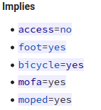
- yes, default access=no + bicycle/foot/mofa/moped=yes
Three possible additional tags:
- horse=yes
- horse=no
- no horse=*
- motorcycle=yes
- motorcycle=no
- no motorcycle=*
- speed_pedelec=yes
- no speed_pedelec=*