I am now looking for a good replacement for File:Wicket gate.jpg - OpenStreetMap Wiki within a fence
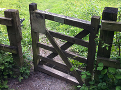
Looking for a small gate for pedestrians, without extra confusing context
Help would be welcomed! (taking a own picture also may be a good idea)
I am now looking for a good replacement for File:Wicket gate.jpg - OpenStreetMap Wiki within a fence
Looking for a small gate for pedestrians, without extra confusing context
Help would be welcomed! (taking a own picture also may be a good idea)
I’d look no further than the English OSM wiki page https://wiki.openstreetmap.org/wiki/Tag%3Abarrier%3Dwicket_gate. There are two examples on there.
As an aside the term “wicket gate” isn’t used much in modern English - they’d normally be described as some sort of “pedestrian access”. However, there are more than a few cases where archaic English lives on in OSM, even relatively modern inventions like https://wiki.openstreetmap.org/wiki/Tag:shop%3De-cigarette - these are almost uniformly referred to as “vape shops” in the UK.
Thanks!
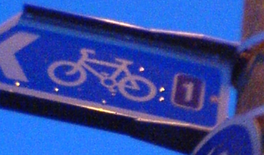
I am now looking for an alternative image of bike pods: File:Bikepods.JPG - OpenStreetMap Wiki

And closeups of bicycle signposts: File:Ncn1-Cramond.JPG - OpenStreetMap Wiki (I have not looked hard for this one but help is also appreciated)
Some context is surely needed here - what are you actually looking for? A direct replacement for that one, or something else?
ideally direct replacement: closeup of route 1 in national cycle network of UK - of higher quality if possible, if not then closeup of other UK bicycle signpost
but other bicycle signpost closeup would also work - potentially more complicated replacements like tweaking descriptions would be needed and there is a higher risk that people would be sad about a change
@Richard may have access to several photos of signs as I believe he has installed them in the past.
Here’s one with NCN route 442 - my pic and you’re welcome to use it under any licence conditions you like. https://twitter.com/richardf/status/1623985172084400129/photo/2
(Also quite a rare picture - in the UK, at least - of a European walking route sign!)
@Mateusz_Konieczny , you can use my picture in Neue Organised Editing Activities für das Radnetz Deutschland (D-Routen) - #6 by Vinzenz_Mai
Licence as you need.
EuroVelo 5 and three regional routes both sides of the French-German border:
Vallée de la Sarre / Saarradweg, https://www.openstreetmap.org/relation/107338
Tour de Sarre / Saarlandradweg, https://openstreetmap.org/relation/76142
Velo visavis, https://www.openstreetmap.org/relation/173747
The image is called Bike pod, what is mapped is bicycle_parking=streetpod.
Not too many mapped, taginfo can tel there are 237 streetpods (0.05%) mapped, I could not find an image on Wikimedia Commons.
Then extracted them and found that most are scattered through Europe but there is one concentration for Newcastle upon Tyne. I did ping the most frequent mapper.
Just to confirm: is everything OK with File:European walking route sign in Britain.jpeg - Wikimedia Commons ?
(do you remember exact date or exact location? Though for location I guess I can try tracking it down…)
are they having any freely licensed images?
The issue is the licensing - being able to download it doesn’t mean it’s a freely licensed image with the rights to reuse it.
Here you go, it’s copyright free:
Let me know if you’d like me to have DALL-E insert some space aliens while we’re at it ![]()
So by bike “pod” are you referring to those docks like you have on short-term bicycle rentals that you have an any urban area?
cool, these appear to have foldable front wheels ![]()
That picture is used here, and a search for those with images finds this, the picture of which seems to have moved here. That one may well be mistagged, but given that there are only 245 worldwide, I suspect it wouldn’t be that hard for the person with the itch that needs scratching here to find a cluster near where people add StreetComplete picture notes, and tie the two together ![]()
The CycleStreets Photomap has >137,000 images of transport infrastructure (mainly cycling, but plenty of walking too), mostly openly licensed.
https://www.cyclestreets.net/photos/categories/
https://bikedata.cyclestreets.net/photomap/#5.23/51.742/3.472
That’s an Italian producer, so probably someone from there… The only replacement on Commons is a svg drawing:
