I’d like to suggest adding a new area-type, named Residential Property, which would be used to mark out residential property boundaries (typically, the garden).
Property names (generally, door numbers) would then be associated with the residential property (not the building).
This would solve the problem where multiple properties are in the same building, as the Residential Property area splits the building up implicitly.
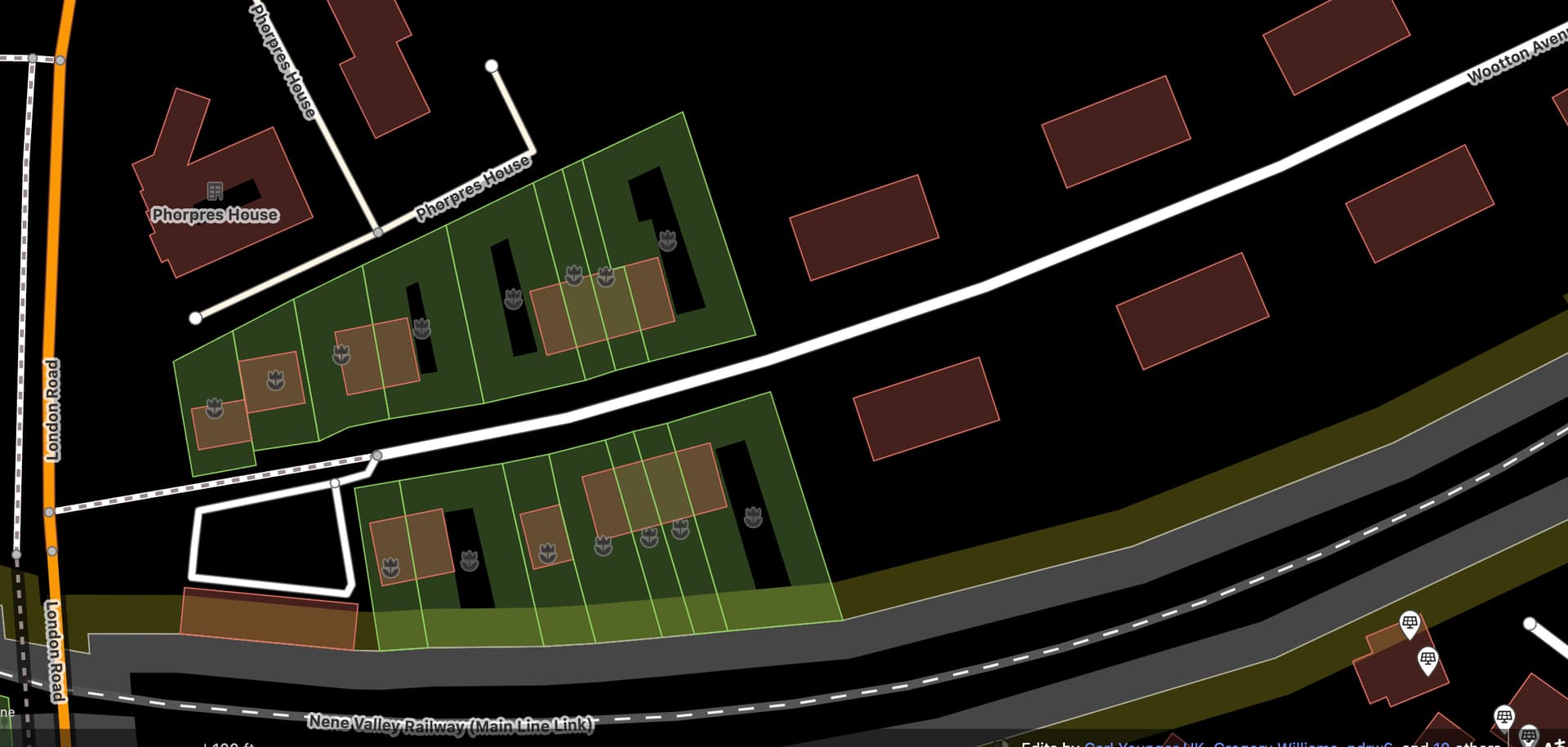
Below is an example, using Garden areas to illustrate how this would work:
Note that landuse=residential is mapped as the gardens+building gound. Since if u use leisure=garden you need to make sure the garden does not overlap with the building.
I’d advise against doing this: it makes the map rather fiddly for other contributors; it’s a huge commitment if trying to do it over a largish area; if the areas are misaligned it is a heck of a job to realign; it’s amazing how much this kind of thing changes; in general the OSM consensus has been to NOT map property parcels. I have done this in the past, and regretted it for the above reasons.
You can of course map garden fences, hedges and walls (you still have the same issues of detail & alignment) which can convey much the same sort of information.
Examples of places mapped like this (in the UK):
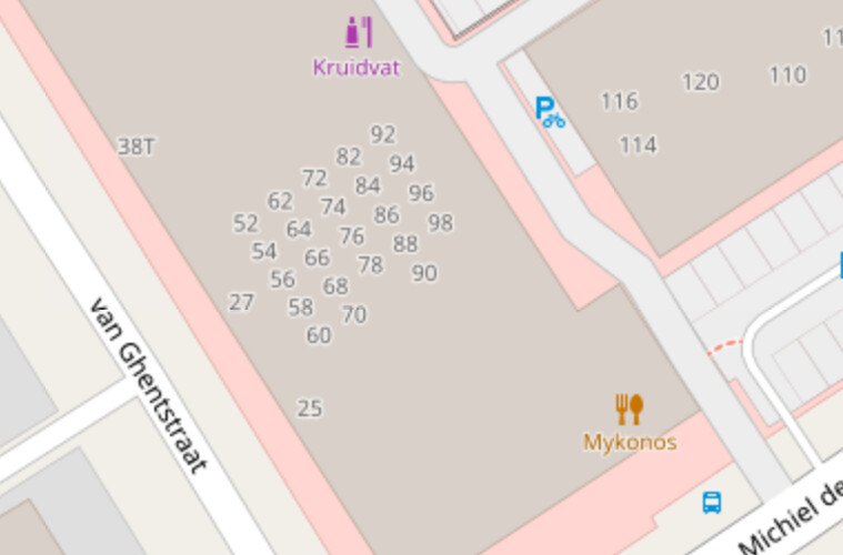
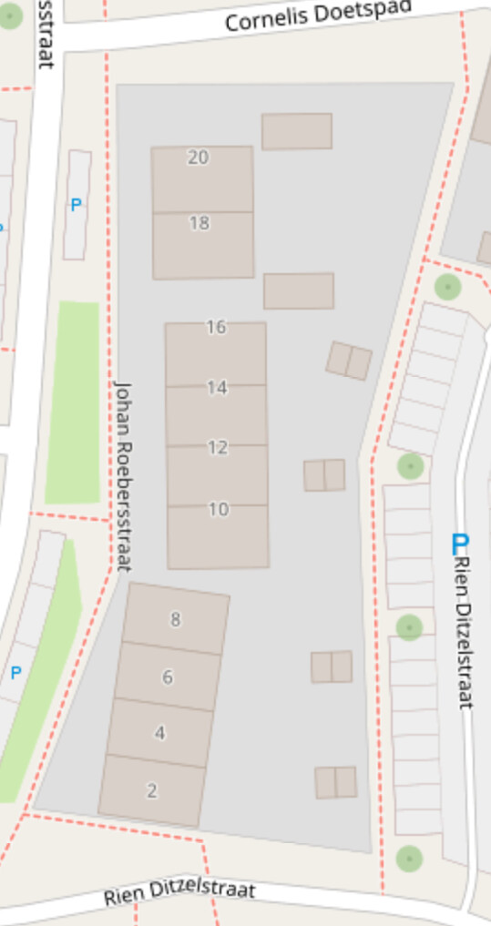
Central Edinburgh. A lot of this was mapped as part of a local history initiative (MESH) which needed accurate address data.
Sutton Coldfield, strictly speaking B72 post code area. Probably the first one to be done on a large scale.
Witney, a relatively recent dedicated micromapping effort. This looks to be being done area by area, but it’s easy to appreciate how much work remains to complete the town to the same level of detail. By way of contrast this is the sort of level of detail where a lot can be achieved in a short time (in this case a morning’s surveying).
simp
No, this is not necessary, it is trivial to cut out the building out of the garden when consuming the data. It also allows certain types of query (e.g., How many houses have their own garden?) to be done simply without any processing (e.g., in Overpass) whereas relations make this more complex.
Thank you for your advice, everyone. It’s really useful information (especially the examples that @SK53 gathered together).
We still have a lot more important stuff to do locally, so this is not a priority. I’ll try to reach out to other local mappers, and see what they think about the options you’ve listed above.
Seems like there are a lot of issues with importing that data. However the discussion was mostly focused on the US. Things might be different in the UK.
Note also Verifiability - OpenStreetMap Wiki issues, as it cannot be checked at all by on the ground survey (EDIT: in typical cases, sometimes in relatively rare cases there is signage - though some of signage claiming to mark parcels is not really doing this…).
As this data can be verified only by checking some official database - then benefit of importing it into OSM is really dubious. Basically all benefits, without problems, can be provided by using them as background layer for mapping.
(yes country boundaries and lower level of administrative boundaries are in OSM but these were basically added as an exception)
On reflection, I’m just going to leave it alone, and focus on stuff that needs doing. The more I learn about it, and consider the implications, the more convinced I am that it’s not wise to start something like this, especially not on my own initiative.
I also hadn’t considered the need to know the actual boundaries. I was just eyeballing people’s garden fences.
yes, more detail always means the map will be harder to edit. When your area is not mature and a lot of alignments and other work still is to be expected, you should rather prioritize these before adding more detail.
Wrt to these properties changing, I think it hardly happens in a way that would require realignment or redrawing, rather it will be about dividing or unifying properties, not about boundaries moving around, especially in builtup areas
it cannot be authoritatively verified without official data, but property lines (supposed property lines) can very often be seen on the ground. Sometimes they are even marked.
I do not want to encourage you to do it, because I somehow agree that it would create a lot of additional complexity and work for all following mappers, for few gain, but generally it would be perfectly ok to eyeball garden fences and walls (what we already do in detailed areas), there is no requirement of official data.
Agreed, garden fences, hedges, walls etc. can be mapped as separate objects and also be used to estimate the extent of a property but for the mapping of property borders I’d say it would be better to have a reliable (official) source in any case.
Good point, sometimes you have also boundary stones and so on - and often they even match actual plots. Though vast majority of property lines are not obtainable or verifiable, and that is before one starts to consider outdated or misplaced boundary markers.
To use landuse/landcover data from OSM it is necessary to do a lot of complex processing anyway. All of it involves making choices assumptions about the meaning of given tags, and the way in which each given class of elements is processed will depend on the underlying use case. In nearly all those cases idiosyncratic aspects of tiny proportions of the data (I can think of 2 houses on stilts out of the 150k in the local area) is just not worth the hassle, as they will not material affect the result. Of course if doing it for a waterside kampong in Malaysia then you start with a different use case and assumptions anyway.
Take two adjacent cemeteries. On the ground they all look the same.
Good thing we can use the property line, that we draw between the two boundary stones separating the cemeteries.
Thus we can make two polygons, with different names for the two different cemeteries.
So this imaginary line through thin air, turns out to be very valuable in making our map correct.
Actually I agree with your idea in general. The opposing comments focuses on land lots, and scalability in small home areas. But large villas can obviously have a visible and verifiable area of control. That’s not to mention there is no feature tag for gated community, housing estates, and apartment complex sites, leaving landuse=residential to be co-opted for this. Which if resolved, can be generalized to individual homes when valid and needed. The lack of feature tag has not stopped people from doing this for both houses and estates.
That’s not to mention there is no feature tag for gated community, housing estates, and apartment complex sites, leaving landuse=residential to be co-opted for this.
there is place=neighbourhood which is a feature tag and should be preferred over landuse which is not
What is a named landuse=military military=airfield, or landuse=retail, retail=retail_park (= strip mall in US), or a named forest area if not a feature.