Hi, I have a micromapping question. If I want to draw a traffic_calming=island area, should I map the painted area or the “physical” area? en.wikipedia says: " A traffic island is a solid or painted object in a road that channels traffic", but since sometimes we have other conventions I prefere to ask. Also we could update the OSM wiki to make it clear.
In case mapping the painted area is the correct option, is there a way to map the physical one as well? I was thinking of barrier=kerb closed way but I read is to be used only for sidewalks, which is not the case.
A kerb is the edge where a road meets a sidewalk.
and Tag the node node on the highway=footway, highway=cycleway, or highway=path
made me think it can’t be used for traffic islands which are not pedestrian/bicycle crossings like this one.
By all means: if it’s a kerb, use barrier=kerb + kerb=*. A kerb is a kerb.
In Germany, we also have kerbs directly on the road sometimes, in order to have vehicles going over it forfeit their right of way. So yes: it’s perfectly fine to use it on any part of the road.
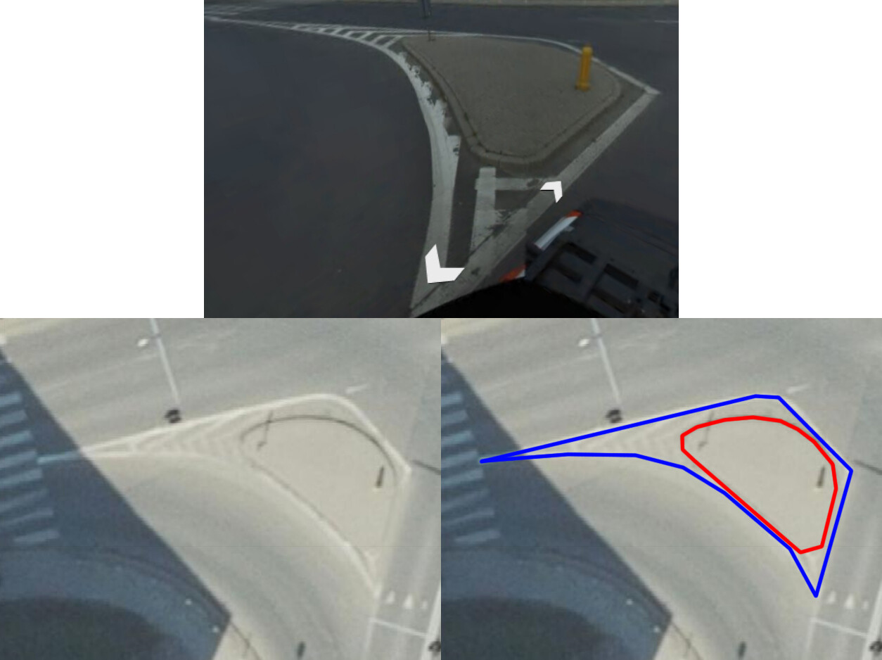
Considering what you wrote, in this case (when there’s a solid area inside of a larger painted area), I therefore propose to map the painted area as traffic_calming=island and the physical one as barrier=kerb + kerb=*.
if there’s consensus I could edit the Tag.traffic_calming=island wiki page adding this tagging schema. Let me know everyone (you can add a or if you don’t want to comment).
To me, the kerb is just the physical border where the footway and the street meet. So a footway crossing a traffic island usually has two kerb barriers:
A kerb is the edge where a road meets a sidewalk.
and Tag the node node on the highway=footway, highway=cycleway, or highway=path
made me think it can’t be used for traffic islands which are not pedestrian/bicycle crossings like this one.
I see, I was confused by the Kerb - OpenStreetMap Wiki redirect. If kerb=* is for “additional detail” maybe it should redirect to barrier=kerb instead (or the page changed from a redirect one to a disambiguation one).
you could also use =apron for a surmountable elevation, often used at roundabout paved inner circle, where the hgv combination last wheels need to take it, to make the curve. truck apron.
On the inside or outside of a curve.
area:highway=* is additionally used to describe the shape of linear features tagged as highway=*.
But traffic_calming=island isn’t a highway=* tag and also it’s already possible to map it as an area, so I don’t really see the point of it in this specific case.
EDIT: By the way, I also found this: Tag:traffic_calming=painted_island… It’s so confusing, also because all these elements aren’t linked to each other in the Wiki. I added a reference to them in the Tag:traffic_calming=island “See also” section.
As far as I can tell, the tag is only being used for islands that are physically raised, but also have an additional painted area around them. This explains why the two carriageways are split at the point of the traffic island.
@ ivanbranco: I just read this discussion. Some comments to your questions:
I use traffic_calming=island together with barrier=kerb (and kerb=* to specify the kind of the kerb like lowered/raised/rolled) already since a longer time.
The wiki page for kerb=* could really be improved IMO (the text is too much focussed on the use for single nodes e.g. on crossing ways). For me, it’s generally a subtag of barrier=kerb to specify the kind of a kerb. The use on single nodes is a special case or only one case.
I also use barrier=kerb + kerb=* on nodes (e.g. of crossing footway), often together with tactile_paving=* to complete it. (Yes – I prefer to use also barrier=kerb PLUS kerb=* on nodes, although it’s not described on the wiki page of kerb=* – but it IS a barrier=kerb, why should it not be tagged in this way? For my feeling, it’s more complete with barrier=kerb.)
The case of a traffic island area with barrier=kerb + kerb=* and crossing footways with nodes tagged with barrier=kerb and kerb=* on the border of the island is quite common for me. Of course, the values of kerb=* should correspond in this case.
The tagging on nodes can be useful for routing applications for disabled people for example (or it can make it easier to issue warnings for such applications exactly on these nodes) and rendering engines can display a special symbol on these nodes. On the other hand, rendering engines (and editors) could use a different rendering of the outline of a traffic island depending on the kerb (or no kerb).
I think, that traffic calming islands (when used for areas/closedways) can be a quite special case of “double feature tagging” or even “triple features tagging” on the same closedway line, if you consider traffic_calming=*, barrier=* and landuse=* as (also) standalone features for ways/closedways. But if you draw separate/duplicated (identical) lines to tag these feature separately, this results in validator warnings (e.g. Osmose).
And some questions are arising. E.g. is it better to use landuse=grass or surface=grass (or even both)? Surface=grass might fit better at first glance, because it “avoids” one “double feature tagging” in the sense mentioned above (and there can also be cases with surface=paving_stones|asphalt|sett…!). But on second glance, there could also be landuse=greenery or landuse=flowerbed or perhaps natural=shrubbery and other values (scrub? wood?) on a traffic calming island (and surface values for these cases are not established). So landuse (or natural) might need to be used anyway … With the side effect, that landuse=grass is rendered on OSM Carto, and surface=grass not – only to mention this, too (and traffic_calming=island areas with no other tags are currently not rendered at all on Carto – not very nice).
As I have experienced, dealing with this type of “double/triple tagging” can potentially be a challenge for editors or rendering engines. The current support in editors (I use JOSM and Vespucci) is perhaps not the best … But it should be possible anyway. I did already enhance the presets and data styling for JOSM and Vespucci for my personal needs. (And I ran into a few obstacles along the way.)
For the question what to tag/draw if there are markings around a (solid) traffic island: I would draw/tag only the solid island, because this is the island, and the paintings around it are additional markings (like other markings on a street). If it’s a painted island, I would also draw the area around the painted part, not any markings around. But I never tagged such an island so far, I tagged (and saw) only solid ones. (Note: for pedestrian crossings, there is a new tag crossing:markings=*, something similar could perhaps also be used/invented for traffic island if micromapping needs to be refined.)
And you’re right … it’s somewhat confusing (specially with the wiki) in such a case and not straightforward, which you might not expect with a traffic island.
Perhaps a proposal covering all these cases and questions wouldn’t be bad for clarification …
Yes, that Wiki page is a mess. I’ve volunteered to improve the page, so I recently started two discussions here to get community feedback and find all the missing uses of barrier=kerb and kerb=* that were not documented in the Wiki: [1], [2]. My summary of what was missing from the Wiki pages is in this post. From reading your comments, I think my understanding aligns with yours. If I’ve missed anything or you have any comments, please let me know in the thread about the Wiki page.
I updated the page for barrier=kerb with the results of those discussions yesterday, and I hope to make the agreed updates to the page for kerb=* in the coming days.
I’m not sure I understood what’s the current situation. traffic_calming=island should be changed with area:highway=traffic_island while for traffic_calming=painted_island there’s still no consensus between area:highway=traffic_island, area:highway=emergency and area:highway=buffer? Is this correct?
Neither! This should not be tagged with traffic_calming=* at all. Mentioned structure does not impose calming the traffic. Use area:highway=traffic_island instead.
traffic_calming=* was meant to be used as nodes or ways ONLY. It was thought to mark roads, or points on roads with features that are designed to slow down traffic. This is reflected in the Wiki as well as in the original proposal (approved).
That means, that traffic_calming=island should be used only to mark traffic islands that somehow make the cars need to slow down. For example by having them to ‘slalom’ around the island (kind of a traffic_calming=chicanes but with just an island in between the lanes). SV Example.
That also means, that areas (and nodes in case of non-traffic-calming-islands) marked using traffic_calming=island are making the tag skunked.
For areas there is area:highway=* tag from inactive proposal, which is still widely used.
for the ‘striped painted islands’ there is area:highway=emergency or area:highway=buffer (no consensus)
I am against usage of traffic_calming=painted_island as it doesn’t make the cars go slower, drivers can go straight through souch features.
for the ‘any island that is made of something different then the road and probably raised’ there is area:highway=traffic_island.
Updated the PLwiki to be coherent with ENwiki (diff)
Added photo of traffic island to the original proposal of area:highway=* (diff)
Changed the name of iD preset, which since Nov 2020 called traffic_calming=island by “Traffic Island” which I think is misleading. Name was changed to “Traffic Calming Island”. (#1074)
OsmAnd has a feature where it warns drivers about incoming traffic_calming=*. Marking non-traffic-calming-islands using this tag leads to false-positive alerts. (source)