How do you tag them in these cases?
Also, there’s not even a traffic light here at all, so I want to designate this as a pedestrian zone.
What are your views?
If something is unclear to accept, I have to wonder why no one is asking for a clearer explanation, rather than making an uncertain claim based on that unclear basis.
I have used crossing:scramble=yes on my own for both diagonal and area crossings. It can be used with highway=crossing or highway=footway as drawn. Dealing with highway=pedestrian (if that’s what’s leading to the background) is trickier, because technically it mixes pedestrians and service/emergency vehicles.
For the geometry, you are free to draw in any shape you want. The difficult with this is the crossing overlaps with the highway= road from the foreground.
The area could use area:highway=, however it is unclear whether this should be area:highway=crossing where it coincides with the intersection. Furthermore, there are differences in the method over the years. area:highway=crossing is from the newer Proposal:Pedestrian crossing as an area - OpenStreetMap Wiki , different from Tag:area:highway=footway - OpenStreetMap Wiki using area:highway=footway + footway=crossing directly.
For reference, the older Proposal:Street area - OpenStreetMap Wiki suggested to use the area:highway=* corresponding to the highest highway=* road class for the intersection area. This is somewhat arbitrary , and will be inconsistent with area:highway=crossing if adopted. There are some uses of area:highway=junction , which I prefer more. Then again, the coinciding intersection and scramble crossing area remains unsolved.
Ps area:highway= is rendered in OSMAnd and Organic Maps.
I’m not directly familiar intersections but I don’t see how they can be treat as junction. It is a normal intersection that could a pedestrian crossing in any particular direction. I would put in the outer crossings as well as two in the middle. That it is obvious to user and routers that a pedestrian can cross from any corner to another.
After considering different cases and situations and comparing the OSM wiki, I concluded that the ‘area:highway=pedestrian’ tag is the most similar.
The rationale is that…
There are too many different pedestrian directions.
There are no traffic lights and pedestrians can enter at any time.
These attributes are very similar to ‘highway=pedestrian’.
Note that area:highway=* areas complement highway=* ways but don’t replace them. The current generation of OSM-based routers is largely unable to route through areas, only around them. As long as the intersection is represented as both highway ways and a highway area, the classifications should be consistent to avoid confusion.
The pedestrian mall in the background of that photo would be highway=pedestrian, so if you map that as an area, it would be tagged area:highway=pedestrian. However, the intersection in the foreground probably should not be highway=pedestrian. That would imply that a pedestrian can loiter in the middle of the intersection, enjoying the right of way over cars, just like in a pedestrian mall or other footway.
There’s also junction=yes for indicating the extent of the intersection. This tag is kind of like your area:highway=junction suggestion, but it comes up often enough that I figure it has a better chance of taking off, for better or worse:
OSM should have the information necessary to properly display the area and to inform a router/navigator.
I think one area polygon would be easiest to hold this information.
Junction=yes on polygon would require additional tags to hold the information about the type of junction, in this case pedestrian.
Maybe it would be easiest to add a more specific value to the junction tag. In this case eg. junction=pedestrian or junction=pedestrian_area.
As a side note, I think it is time for routers to actually implement routing over an area. Not necessarily to determine the exact route within the area, but to accept an area as part of a route. The entry and exit points fixed, and the trajectory in between left open (the user has to find his/her own way). A nicely curved and dotted line between entry and exit? A proper message informing the user of the situation?
Can you explain how you would draw the intersection area? One advantage of =crossing and junction= as I see it is you can split the intersection area to pure =crossing , and pure =junction . If you draw a area:highway=footway + footway=crossing , you rely on the implication it is a roadway area, which area:highway=footway itself is not. Otherwise, others may be tempted to draw the area:highway=residential (for example) across it, as an overlapping area. Besides, the area is a roadway area foremost, being crossed by the crosswalk. So it doesn’t belong to either.
The problem with junction=yes is it’s unnecessarily interpreted as a “named” junction on points. By extension, this would apply to areas.
Is it a given that area:highway areas can’t overlap? A crossing is by definition a dual-use space. A junction=yes, meanwhile, is orthogonal to all that; it could include or exclude the crossing, depending on the situation.
It’s best to not have overlaps for simplicity. As area:highway= is defined basically as a physical roadway area, it’s redundant to have both, and the linear highway= fills the gap as an explicit functional object, If this is recommended, should intersections have overlapping area:highway= road classes to show their respective paths too?
Besides these 2 issues, there is area:highway=turning_circle for not using the road class. (I doubt the usefulness of area:highway=turning_loop . The exception to solvable overlaps is area:highway=footway inside a area:highway=traffic_island for refuge islands, medians, and inner sidewalks (depending on definition).
Ah! I sincerely apologize.
Please forgive me for not responding to your comment earlier. (I realize this was very discourteous of me.)
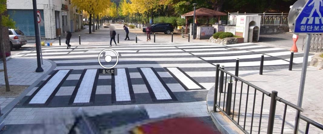
Though belated, I will now share the location of the area in question.
** Although the discussion had stopped a long time ago, I left a comment to help inform the “Mapping ‘scramble crossings’” thread. I would appreciate it if you could keep the focus on the “Mapping ‘scramble crossings’” discussion.
If I look at this correctly, as driver you are entering a crosswalk (zebra), have to turn left on the same zebra. In the meanwhile, you crossed two other crosswalks/zebra’s made for pedestrians? It doesn’t make sense to me why the surface of the driveway is changed to a zebra. If it where both pedestrian street I could understand, but this?!?
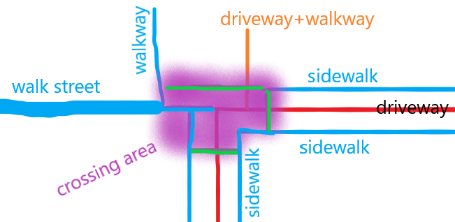
I would tag it the way you did in the second image. With the green ways tagged as footway+crossing+markings=zebra. The area can be tagged as area:highway with something like markings=zebra and junction=yes (for instance Way: 964402755)
Are there any signs that would tell a driver it’s a pedestrian zone? Or is there something in the law that these stripes are always for pedestrians to walk on?