[Survey] How to tag pathways of unknown classification?

How to tag pathways of unknown classification?
Before voting, ensure you have read the summary below!
  • highway=road
  • highway=unknown (Proposal)
  • highway=path (without additional or certain tags, TBD)
  • As a line without any highway tag
  • Other approach (comment below)
  • Not sure
0 voters

highway=road

highway=road is used for “roads of unknown classification.” These aren’t expected to be routable and should appear in a unique style to encourage mappers to survey and reclassify them based on local knowledge.

While not widely used, this tag is incredibly helpful for armchair mapping or importing external data, especially when local knowledge is lacking.

Controversial imports (like Facebook and Grab, from what I know) used highway=track or highway=residential without local knowledge, leading to a lot of false positives or incorrect classifications.

Important Note: Although the current wiki suggests it can be used for pathways, this wasn’t the original intention. Most renderers treat it like a minor road.

Some mappers argue that highway=road should apply to pathways too. After all, a path is a type of road, right?

highway=unknown (Proposal)

Besides extending its scope to pathways, I’ve proposed renaming highway=road to something less confusing, like highway=unknown.

highway=path (without additional or certain tags, TBD)

Another suggestion is that highway=path (without extra tags) could act as the equivalent of highway=road for pathways. However, highway=path is:

  • Always routable
  • Always rendered in the same way
  • Commonly used for multi-use paths and outdoor trails

As a line without any highway tag

Others have suggested adding unclassified data as a line without highway tags, but:

  • It wouldn’t appear in renderers, offering no incentive for mappers to refine the data.

Unverified data should not be added to OSM

Some believe that pathways of unknown classification shouldn’t be added to OpenStreetMap at all, but:

  • You can’t stop data from being added. Even imperfect data gives an incentive to mappers to improve the map.
  • This is exactly what armchair mapping does when relying solely on imagery.
  • There’s a range of lifecycle tags (disused:highway, abandoned:highway, not:highway…) to mark false positives and prevent future mistakes.
  • It seems unfair that roads of unknown classification can be tagged , but pathways could not.

For these reasons, I’m not including it as a survey option.
Linked discussions:

I’m not fully sure what a “pathway of unknown classification” means?

If you know it’s a pathway, doesn’t that mean you essentially have classified it as highway=path already? It’s not like a road which could be tertiary/unclassified/residential/service. Do you have in mind that you don’t know whether it would end up as path/footway/cycleway?

8 Likes

Yes, for instance a visible narrow path on imagery backed up with GPS trace or Strava Heatmap, will be some kind of path, but it could be well a footway, cycleway, or steps.

Take for example any ways tags with highway=path without additional tags. Is this a hiking trail?, is it restricted to bicycles?, is it a footpath made of steps ? is it a mountaineering path ?

On the other hand, I could ask the same question here, what is a “road of unknown classification”? how do you know based on imagery it should be some kind of road ? Maybe that you think is a highway=track was actually too narrow for motorcars.

I could live with pathway=unknown.

Maybe in the future, but for no, pathway=* isn’t a top-level tag and doesn’t have a formal proposal, so what’s the best alternative in the meantime?

If I know that it’s not vehicle-traversible, it gets highway=path. If it might be something like a logging road, it’s highway=road.

3 Likes

Is the question “I know there’s a path(way) here but I’m not sure what kind it is, how do I tag it?” or is the question “I know people go here but I’m not sure if there’s a path, how do I tag it”?

Because the two are very different questions and @SomeoneElse’s suggestion not to map it at all was in the context of the second question.

2 Likes

Or even a 3rd situation “I know there is a path here but I don’t know how it connects to other paths or roads”. That seems to have been one of the main cases that prompted this discussion. But the proposal doesn’t directly mention whether it is intended to cover this.

1 Like

Good point! I’d say it’s more like the first question, plus, ‘I know this way is popular so I’m confident there’s some kind of path.’

Not exactly. The takeaway from that discussion was that if paths are clearly visible in imagery, they should be mapped as highway=road (or highway=path). However, those with low confidence shouldn’t be mapped at all.

I didn’t think disconnected characteristics were a deciding factor. If I see roads in imagery but don’t know how they connect, I would still try to map them as highway=road—because I’d be missing the important details on their connections.

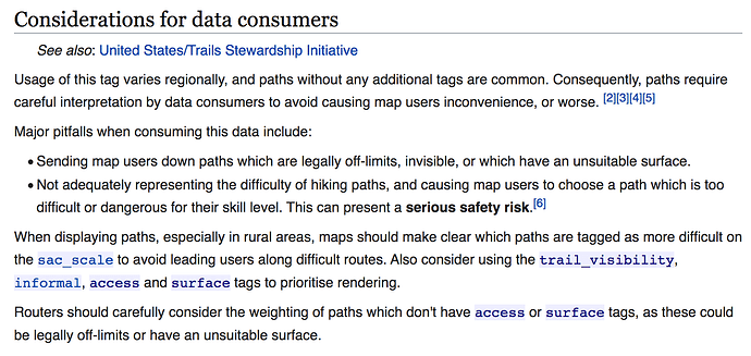
These are routing/rendering problems. Routers shouldn’t route on a path without more/better tagging. A useful map will render paths like this differently also.

2 Likes

Then that section will definitely need stronger recommendations because I don’t know of any popular routers or renderers that currently work like this.

For example, I’d expect to see something more like:

  • highway=path without additional access, surface, and difficulty tags should be rendered with a distinct style from any other pathways to inform users about their unknown status.”
  • “Routing profiles should exclude highway=path if they lack any related difficulty, surface, or access tags.”

Now compare that to the current highway=road wiki:


1 Like

I answered “Other approach (comment below)”, so here’s the comment:

First things first, the question’s a bit ambiguous - “How to tag pathways of unknown classification?” implies that you’re thinking about adding something that you think is a “pathway” (whatever that is). Comments earlier have suggested that this might be:

  1. something that you can see on imagery is definitely some sort of highway, that may or may not be wide enough for regular vehicular traffic.
  2. something that you can see on imagery that might be some sort of highway, or might be something else altogether, or might once have been a highway but now no longer is.
  3. something that you’ve got from some other source such as Strava, that merely says “someone recorded a GPS trace here”.

I’d handle each of these cases very differently. For (1) it does make sense to add some sort of highway tag to OSM, but I’d definitely try and make it clear in the changeset what the source was. It doesn’t make sense to me to add (2) or (3) as any sort of highway - that’s just guesswork, and OSM should be better than that.

If the source isn’t easily browseable I’d probably add a personal marker outside of OSM to check it next time I’m in the area (I use Garmin devices and this to process waypoints and routes).

When reading of classification, my first question would be, according to which scheme. In the “summary below” I did not find reference so such a scheme. A scheme for roads is mentioned, but I do not know if that applies to pathways? I have no idea, what a pathway is.

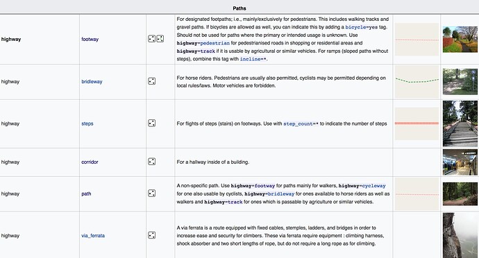
Here are the classifications defined under “Paths” section in the Key:highway wiki.

“Pathways” would be a better term since it’s a broader and more formal, whereas “Paths” could be mistaken for the specific tag highway=path.

2 Likes

Some background context, for those who missed this thread:

1 Like

There are three types things represented by highway=path objects that I can think of:

  • Rural/wilderness trails. These are where most of the issues with routing and rendering lie (not routing people onto private land, closed/emergency-only trails, or into excessively difficult conditions). The good news, though, is that most of this data is maintained by folks who are at least somewhat specialized in the issues accompanying rural trails (and have the wherewithal to reach and survey many), and the Trails WG is available as a point of contact for mappers who need guidance on this front.
  • Urban multi-use paths/trails. Some mappers use highway=path instead of highway=cycleway for multi-use trails, which is understandable (if perhaps not the cleanest). These are almost always improved trails, and while routing someone down them is generally not undesirable, many times they have been traced from aerials using bare highway=path due to a lack of further data. (surface=paved, at the very least, would be a strong clue that this should be a routable trail, likewise with explicit access tagging for non-motorized users, although this can’t always be definitively determined without survey or consulting local rules.)
  • Urban informal pedestrian paths. These are generally going to be highway=path informal=yes, without much if any further tagging (especially if armchair mapped), but represent a very different routability situation than their rural counterparts. This is because many US cities are plagued by inconsistent pedestrian infrastructure that requires the use of informal paths to make logical connections, and treating them as non-routable will outright break pedestrian routing in areas that use these to plug holes in otherwise-separately-mapped sidewalk networks.

Given that data consumers probably don’t want to base routing or rendering decisions on the presence of a containing urban entity, and category 3 will probably persist for quite some time out of sheer necessity, is there something we can do to help data consumers distinguish these cases without requiring survey-grade tagging every time highway=path is used?

3 Likes

I answered “Other approach.” Here’s my comment. I’d ask, why are you mapping highways and paths without classifying them?

If I could not determine the classification of a highway or path, I would not map it. Consider:

  • With reasonable quality aerial imagery, you can determine:
    A. Whether a linear feature on the ground has one or two tracks or is generally wide enough for four-wheeled vehicles. This is enough to decide between highway and path.
    B. The general quality of the surface of the feature, whether it is maintained or unmaintained, paved or unpaved, relatively smooth or rough, relatively hard or soft. This is enough to make reasonable guesses at surface, smoothness, and tracktype that can be adjusted after subsequent surveys.
    C. How frequently and recently the feature has been used (in the case of features with soft surfaces). This can help inform classification decisions.
  • Based on boundaries of protected areas (e.g., Wilderness), you can determine whether certain types of travel on the feature are restricted.
  • Using street-level imagery, you can identify signage that may also restrict access.
  • Using information from the local land manager, you can identify what types of travel are permitted and when.
  • Looking at the classification and usage of existing highways and paths in the area, you can determine the relative importance of this highway/path in the transportation network, and make a reasonable guess as to how the feature should be classified.

So, if you’re mapping highways or paths of “unknown” classification, you could do a lot better. And if you come across something tagged as highway=road, you could use these techniques to improve the tagging.

Can you provide an example of this?
It seems to me that a non-local should not be routed on a path that has been poorly armchair mapped.

1 Like

This is undoubtedly true in some parts of the world, such as where you and I come from. However, more often than not, the available imagery or contextual data (like protected areas) is inadequate for reaching many of these conclusions in developing countries, especially those that had been dependent on Maxar imagery. There still needs to be a clear answer for those regions. If I understand the original prompt correctly, then highway=path is more appropriate than highway=road in general, but there’s always room to apply common sense.

1 Like

Not if the path is under tree canopy, especially evergreen canopy.

No, in the US National Forests that I have visited some trails allow bicycles, while others do not, the same applies to horses and motorcyles. Access using a particular mode of transportation may even be restricted based on season. In a national park near where I live, some trails allow horses, while others do not. You can’t determine access based only on protected area status, at least not all cases.

Land manager data is often wrong, and their digital data often conflicts with the signs along the trails, which in turn can differ from their official web pages/pdf documents.

3 Likes