lokale Gebietskenntnis… Anders kann ich das nicht beschreiben.
Ich habe ca. 400 Meßtischblätter Land Brandenburg in meiner Sammlung (Kopien aus Bibliotheken nicht mitgezählt). Ich hab eine Landesabdeckung von ca. 90% und öfters Ausgaben unterschiedlicher Stände.
Alleine Kartenvergleiche Meßtischblatt mit DDR-Karten (z.B. Ausgabe Staat) mit TK10 (vorläufige Ausgabe; basieren auf den Ausgabe-Staat-Karten) mit aktuellen DTK10 in Brandenburg zeigen, daß sich Namen von Erhebungen hier nicht geändert haben.
Wenn du auf den Marienberg mit seinen 110m gehst, steht da natürlich kein Schild “Marienberg 110m” Es ist trotzdem der Marienberg. So ist das mit großer Wahrscheinlichkeit mit der überwiegenden Zahl an Erhebungen jeglicher Art.
Wenn du nach Kockrows Berg gehst, denkst du: “Hä? Was soll das denn?” Den Namen findest sich nicht ohne weiteres irgendwo. Die kleine Talsandinsel heißt aber eben Kockrows Berg… Hinweise z.B. im ALKIS. Hier in Flachland sind gerne mal Erhebungen >1-2m über der Umgebung bereits Berge… Is eben so…
Die Datennutzungsmöglichkeiten hier in Brandenburg sind bekannt.
Also da, wo ich lokale Gebietskenntnisse habe, da brauche ich keine amtliche Karte, um das mit meinen Kenntnissen abzugleichen…
Ich habe auf der verlinkten Karte jetzt einmal stichprobenartig nachgeschaut. Da findet sich ein Waldstück, das mit “Dachsbau” bezeichnet ist. Das kenne ich nicht - und das will dort etwas heißen. Im BayernAtlas wird das mit “Hospitalholz” bezeichnet. Das ist ebenfalls falsch. Das kennt man vor Ort ausschließlich als “Spitalholz”, weil es früher im Besitz des Heilig-Geist-Spitals war (und nichts mit dem Krankenhaus “Hospital” zu tun hatte).
Aber das ist OT.
Hier geht es um jemanden, der selbst erklärt, keine Ahnung von den Namen zu haben.
Nun, eine Karte zubetrachten ist das eine, die Namen entsprechend zu interpretieren und zuzuordnen ist das andere…
Wir haben z.B. Bunterstiel Da ist mittlerweile eine Gedenkstein, da das alte Landesgrenze Sachsen - Brandenburg war… Ich muß man schauen, ob ich ein mappingfähiges Foto habe…
Na so OT ost das nicht. Anhand dessen, ob es Kursiv ist, rückwärts kursiv oder Normal geschrieben, erkennt man grob eine Namemszuordnung. Diese feinen Details werden anscheinend leider nicht mehr in der Detailtreue angewendet.
Kursiv: kleinere Orte und Siedlungsplätze oder Landschaftsnamen.
Rückwärts kursiv z.B. Seen und Flüsse.
Nicht kursiv: z.B. Berge und so…
Ich hab jetzt aber keine Meßtischblatt-Legende in Petto. Ich glaube, da ist sowas erläutert.
Thanks, that’s the best answer to my question so far. The maps are quite old indeed, but if there is nothing better than asking locals, who can make things up, have their “family names” of hills etc., then this is the best source.
If I use it, I will try to confirm the names from other source before adding them to OSM.
You will find the same topomaps combined for the whole of Germany under the link posted by @streckenkundler in post #18:http://susudata.de - no need to search for single sheets here, just zoom in and out.
Ja, das stimmt natürlich, die alten Karten beinhalten Fehler, genau wie neue Karten oder die aus OSM-Daten erzeugten ebenfalls, aber unglaublich viele Details speziell im Bezug auf natürliche Objekte sind nach wie vor aktuell und stimmen mit den Details überein, die von den Ortskundigen bestätigt werden. Ich benutze diese alten Messtischblätter oft und gerne zu gegenchecken von neueren Daten oder verbalen Auskünften.
The maps of the first link are included in the map application of the second link.
These are the same maps, only put together as a sheet-free map. Missing maps come from third party sources. However, such maps and their information are copyright-free anyway. On the one hand because of the time and on the other because there is no institution that can claim copyright for map works published before 1945. This is the result of a personal enquiry on the subject at the Berlin State Library https://staatsbibliothek-berlin.de/ ; independent of OSM.
In short: If I am in possession of exactly such maps! There is no copyright holder. I am allowed to grant rights of use for these maps (DE: =Meßtischblätter), which were created before 1945 and which I have in my possession, according to my ideas…
das kann ich auch bestätigen, sowohl außerhalb aber auch innerhalb der Stadt: die (damaligen) Flurnamen für Gegenden die seit ich lebe bebaut sind kenne ich alle als Namen von Bushaltestellen oder Straßen. Außer einem großen Wohngebiet aus den 70ern, das hieß damals “Übungsplatz”
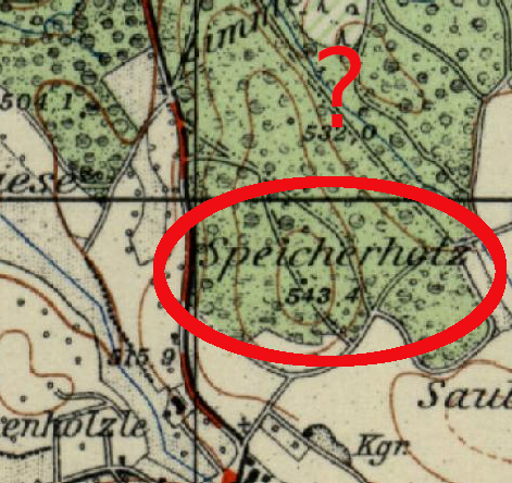
It seems that in the Konstanz region on the old topo maps the name of peaks are maybe hard to distinguish from field names (german: Flurname, which occur in forests as well. By the way: I don’t recommend using the old topo maps for field names, because they are not shown systematically on these maps).
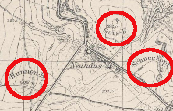
I used these maps in the past to get some peak/hill names of the Trier region. It was very easy, because they are indicated in a specific way (round text). From what I see in the Konstanz region this is not the case. I marked the helpful map style (Trier) and a potential “false friend” (Konstanz) on the images.
Was anyone able to use the historical maps from susudata as a layer in JOSM? It’s not a big deal since the right click in the web map shows coordinates, but it would make the work even easier. I haven’t been able to make it work though.