Also in most European countries star systems are based on objective factors: size of room, services available etc. I once worked with a hospital which was aiming for the “hotel” functions (catering, patients rooms etc.) to match the 3* criteria for hotels then in force in The Netherlands.
1 Like
I was mostly responding to the sac_scale / other difficulty scales part rather than the visibility part.
From a visibility standpoint I know of at least one instance where there is a definite path, then a recreation area, then the/a path continues. So far I haven’t joined them with an “invisible” path, but I’ve been tempted.
1 Like
I don’t mean to be pedantic about this, but I wouldn’t call a tag that’s mainly used in Europe and the east coast of the United States “widespread.” Sure it’s used, but it’s very Eurocentric.
That’s at least better than trail_visibility which doesn’t even seem to be coherent from one user to other, let alone follow any kind of established standards for when or how to use it. Although I do wonder what the usefulness of the star rating system is to begin with if it’s not consistent across the board since people who visit hotels probably aren’t going to be from the local, or even regional area. But that’s a conversation for a different time. I don’t want to side track this by making it about star ratings. It is a good example of the inherent issues these types of subjective, ratings based tagging schemes have though.
2 Likes
Should we strive for a global or regional consensus for things like trail visibility & difficulty?
Yes we should, and not only for trail visibility and hiking difficulty, but for all tags (that’s why we have a wiki). It is especially important for quality grading schemes such as smoothness, tracktype, mtb:scale, etc. that are somewhat subjective. Consistent mapping adds to the quality of the map, so we should strive for it, though realising that perfect consistency does not exist.
Off topic: I’m amazed how quickly discussions on this forum go off topic…
9 Likes
The reason I indulged the hotel stars tangent above is that it does a good job of illustrating the tradeoffs around ensuring consistency. Because stars is a single key that’s guaranteed to be inconsistent across countries, data consumers can’t do anything more intelligent with it than display its value verbatim when selecting a search result. That’s not necessarily a bad thing: a user looking for lodging in their country will understand this system better than any other. But a user from abroad would need to adjust to this system.
I’m not experienced enough with outdoors pursuits (other than field-mapping) to comment intelligently on either trail_visibility=* or sac_scale=*, but I have often seen trails signposted with a difficulty level according to an ad-hoc system, sometimes inspired by piste difficulty markings.
If this difficulty level is useful enough to signpost, it’s probably worth exposing to the user, probably via a separate key. Otherwise, I don’t know how a data consumer could confidently derive the same succinct, intuitive rating from OSM’s SAC-esque scale. As it is, mappers are stuffing the ad-hoc ratings in name tags because they expect the ratings to appear in map labels:
- Way: Scout Trail (Green Difficulty) (952822579) | OpenStreetMap
- Way: 1st Finger (Moderate) (71320760) | OpenStreetMap
- Way: Bear Bait (Most Difficult) (796688040) | OpenStreetMap
Globally harmonized classifications can help data consumers make better automatic decisions: prioritizing a major city’s label over a nearby town’s based on place=*, color-coding roads based on highway=*, penalizing a smoothness=very_horrible trail, or preventing a route from going down a T4+. Meanwhile, recording verifiable, locally recognizable classifications can help users make decisions of their own: choosing a three-star hotel over a one-star motel, patronizing lgbtq=welcome establishments, or deciding against a “difficult” trail in favor of an “easy” one. It all adds to the quality of the map.
4 Likes
Probably it should prefer whatever scale is used locally, but allow conversion to others? (In the same way that OSM uses feet and inches in the US and meters in other countries.)
Here is an equivalent discussion for climbing grades:
https://wiki.openstreetmap.org/wiki/Talk:Climbing#Prefered_grading_system
In the US there’s the Yosemite Decimal System (YDS) (which is used in climbing:grade:yds_class but also applies to trails) and apparently there are different scales for Shenandoah National Park, Willamette National Forest, etc.
There’s an attempt at a conversion chart here: Hiking/Scrambling Grade Conversion Chart : General
I wholly disagree with the idea that we shouldn’t have difficulty/visibility/smoothness/solidness ratings just because they’re “subjective”. For comparison, climbing route grades are subjective, and people may disagree about the exact number, but they’re absolutely necessarily for safe climbing and planning.
1 Like
You’d have to agree that mountain climbing is a completely different thing then hiking 99% of the trails anyone is going down. It’s completely farcical to act like hiking is a super dangerous thing or on the same danger level then other outdoor activities like mountain climbing, skiing, or really anything else involving the outdoors. Especially since a good majority of deaths are caused by things that have nothing to do with the particulars of the trail and everything to do with bad planning (like not bringing enough water) or random chance (falling into a mineshaft or getting attacked by bear).
That’s completely different than mountain climbing where the dangers are inherent to activity. In no way is a “visibility” scale for paths at all necessary for safely hiking though. Let alone is one absolutely necessary. Really, it’s essentially worthless. And I say that as someone who has spent most of my life doing backwoods camping and hiking in all kinds of environments, conditions, and have tested out the trail_visibilty tag and similar ones many times to see if any of them are actually useful. They aren’t. Let alone did I ever need any of them to be safe while camping or hiking. It’s fine to support the tag, but the hyperbole and overselling about it like the tag is gods gift to hikers or something is super cringe. It also just undercuts the credibility of the whole thing in a way that it doesn’t really shouldn’t be. We can discuss the merits of the tagging scheme and improve it without acting like OpenStreetMap would litterally have blood on it’s hands without the tagging scheme.
In my region (New England USA) we have a moist climate in which trails get overgrown and become invisible due to revegetation within only a few seasons of neglect or low use. Trail visibility is a real issue as highlighted in this public radio story which documents how numerous people (generally novices at the outdoors) get lost (and some die) by stumbling onto pirate mountain bike trails and losing their bearings and not being able to consistently follow the trails. This is not to say that the danger is on the same order as mountaineering – but it is most certainly not non-existent. Not bringing enough water is distinctly a problem when what one thought would be a 2 hour loop turns into a 12-hour slog because of getting lost either due to loosing the trail or trying to find an alternative to a difficult section.
In my community many of our single-track mountain bike trails might be relatively easy to follow in mid-summer when many wheels pack the treadway in sections between rock outcroppings, but become almost impossible to follow from October through May as autumn leaves cover them and then get packed by snow uniformly with the rest of the forest floor. As someone who has regularly ridden these trails for 25 years even I sometimes loose the treadway in anything other than the height of summer.
In contrast, other trails in the same area are much more visible year round due to width and construction and are easily navigable by novices.
Just because an experienced outdoors person in one region of the world “never has trouble with trail visibility” doesn’t mean that this isn’t an issue for others and isn’t considered by them important to map. I want a map that shows the distinction between very visible trails and those that are little more than animal tracks. Having recently taken some older relatives who are novices at hiking on what I personally considered an easy hike I was surprised at how much a fear of heights and ankle twisting can be a limit to the accessibility of trails that include even mild scrambling or exposure.
7 Likes
When I’ve looked into this in the past, rock climbing is only about 30% deadlier than hiking (per participant per year).
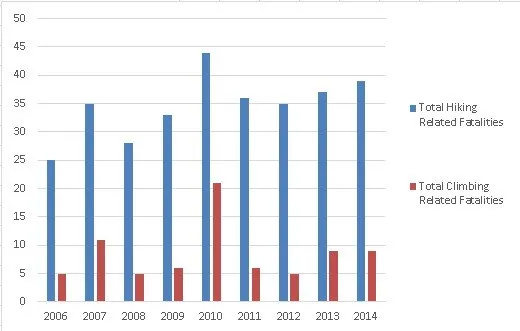
The Centers for Disease Control has reported the third most common source of injury in the wild outdoors is hiking, second only to snow boarding and sledding. In fact, more injuries and deaths are ascribed to hiking each year than to inherently dangerous activities like rock-climbing and mountaineering.
Slips and falls make up about 50% of all hiking fatalities.
Isn’t that exactly what this tagging is intended for? Planning a day to be within your capabilities?
5 Likes
I think what your talking about is illustrated well in the first image from this post. In that case the “path” is covered by some broken branches, but it’s still clear where the “trail” is because of the clearing in the trees. If you want another example, there’s this image from Wikimedia Commons. In both cases I’d agree the “path” isn’t very clear in either one. But a “trail” is more then just the “path”, it’s the complete field of view of the person hiking, and no one hikes by looking directly at the ground all the time. What people do instead is constantly shift their focus between the foreground and background (or horizon depending on how technical you want to be about it). So sure the path in the second image is overgrown, but it’s still complete visible where to go because of the clearing in the trees at the top of the hill. Same goes for the first image, it’s pretty obvious where the path winds around the tree on the left side in the background despite the over growth. So sure, you can say path is invisible in both examples because of the overgrowth all you want, but so what? Again, no one stares directly at the ground when they are hiking.
I read through the article. This is a quote from the District Trails Manager on the Pemigewasset Ranger District from taken directly from article "And we’re walking on some trails that aren’t exactly legal. And they’re pretty clearly defined. Now maybe you can answer me this, does “pretty clearly defined” sound like the trails have a real issue with visibility or maybe the people who got lost were just disoriented because they were unfamiliar with the area? You’d have to agree that someone being lost because they don’t know the area well is different from them being lost because the trail isn’t visible.
Sure, but there should at least be some or at the least an example of where someone had trouble because of trail visibility if your going to cite that as a reason for why the tagging scheme should exist and so far all I’ve seen is a news article about clearly defined trails intermixed with a lot of hyperbole. Granted the hyperbole isn’t coming from you, but there’s definitely been a lot of it over the years this has been a topic. Yet 13 years later I have to see any solid evidence that trail visibility is even an issue. At least outside of a few cherry picked examples that probably had nothing to do with it in the first. Let alone have I seen evidence that it’s a problem that can be resolved by these tagging scheme.
I had a feeling someone would bring that up. The problem with that statistic is that it’s on the raw number of people killed, when the relative danger between two sports is usually calculated based deaths per 100,000 people. Otherwise you could say that free climbing El Capitan is the safest outdoors sport because the only person who did it lived, meaning it has a death rate of 0%.
Anyway here’s the statistics based on deaths per 100,000 at least according to this meta study rock and ice climbing has a death rate of 6.77 per 100,000 persons annually. Whereas trekking, which is essentially hiking, has a death rate on the top end of 0.15 to 0.00023 per 1000 people annual depending on the location. So even at the upper end of death rates hiking is essentially benign. Rock climbing is definitely multiple orders of magnitude more dangerous. 6.77 per 100,000 versus 0.14 per 1,000 on the higher end or as little as 0.00023 on the lower end. Either way, they aren’t even comparable and hiking has almost zero risk associated with it.
I mean sure, you could take any combination of two words, turn them into a tagging scheme, and say they are for planning a hike. That’s a completely different thing then the question of if that two word tagging scheme you just invented is an effective and useful way to help people plan their day though. “The tag helps people plan for their trip because it helps people plan for their trip” is just circular reasoning that probably won’t lead this discussion anywhere except for 13 more years of arguing about it. Personally, I’d like to see this move forward at some point and hopefully sooner rather then later. I doubt that will happen if we just talk in circles all day about it though.
No. That’s a nicely-visible trail – I’d rate it “good” or better. An obscured trail is one where you’re following it more by touch than by sight, feeling for the packed dirt of the trail surface or the weak spots where the brush is growing in from the sides rather than up from the ground.
So would I. That was kind of my point since Adam_Franco said overgrowth and revegetation effect trail visibility. At least in that image it apparently doesn’t ![]()
13 years later and we can’t even figure out among ourselves if overgrowth effects trail visibility or not and supposedly this a useful tag ![]()
No, it’s per participant per year. Raw numbers are higher for hiking because there are more hikers.
Your stat of 0.15 per 1000 for hiking is two times worse than your stat of 6.77 per 100,000 for climbing. Regardless, they’re similar (though I’m still not sure how this is even relevant to the usefulness of tagging trail difficulty/visibility).
1 Like
Just an FYI, but it really doesn’t help when you edit the original post where you made the comment hours later to change the percentage. Anyway I’m not really sure what talking about when you say it’s per participant per year. The article you linked to has a graphic that displays the total numbers of fatalities per year and it’s literally the number of people that have. Not how many have died as a preparation of overall hikers or per whatever thousand. Just the number of fatalities and you can’t judge how deadly one activity is compared to another that way. For instance 9 climbing deaths in 2014 versus 39 hiking deaths in that chart doesn’t factor in that millions of people went hiking in national parks that year versus like 10% of that many if even going climbing. Of course there’s going to be more hiking deaths because there’s exponentially more people hiking then rock climbing. That doesn’t make it more dangerous though.
Yeah but that’s on the extreme high end. The lower end is 0.00023 per 1,000, which wouldn’t be worse and is essentially a rounding error regardless. So be my guest and toss the climbing thing out of this. It still doesn’t negate the fact that hiking is essentially a benign activity that no one really dies from.
Fully agree with your stance on subject, still want to mention, from the point of view of a location that is a tourist destination with incoming people with differing ablities; Where there is only little wilderness, and the visibility of 90+% of trails is good=excellent for somebody out in the wilderness for days on one go, i.e. people who often will find deer tracks not meant for human traffic of good if not excellent visibility, the difference between excellent and good might better be judged from another PoV?
ADD: Here some pictures Category:Wildwechsel - Wikimedia Commons - no English page, perhaps Category:Animal trails - Wikimedia Commons - but a link to Hungarian wiki that advises against going there, because the boar will not go out of the way.
A few replies to what’s been said here already.
I described that as good in my post, and it’s a useful example of how just relying on surface etc doesn’t replace visibility, as it is less visible than many surface=compacted trails in that thread that would clearly be described as excellent.
That’s because… the trail isn’t actually overgrown.
There’s very little vegetation on it compared to the surrounding terrain, and what vegetation is there is obviously far younger than the surroundings. It’s an abandoned trail not shown on official maps anymore with some twigs on it that gets light year round traffic.
This makes a lot of sense to me (and mirrors some of my thoughts in the previous thread). The “mental load” model vs plodding is a very useful way of looking at it. I think the first example would only be excellent as things stand. As defined the second and third would overlap from good to intermediate, and then the last would include bad, horrible, and no.
The “can just plod along looking at their feet or chatting without wondering if they are still on “the trail” or not” and " A key distinction is that losing the path is possible for novices and there is some mental load of looking ahead for those not familiar with the path" feel pretty perfect.
The third seems harder to define clearly - it’s more of what “intermediate” should be IMO. As of now intermediate and bad are essentially the same rating (mostly visible vs sometimes invisible) but this makes sense to me.
The fourth should include trails that “come and go” it reads now that it’s essentially entirely pathless. On the other hand there’s a IMO strong case to be made for breaking these segments into a true visibility=no, and having visbilities above that separate segments, but that’s another thread I’ve been toying with making.
I think it’s ridiculous that in the current rating there’s one for a clearly visible continuous trail (excellent), one for a (nearly) continuous one with adequate visibility one (good), and then intermediate through no are just different proportions of “there isn’t a path”.
I think there can be regional differences in this - a novice that is used to only gravel paths might get confused by a single track dirt trail that people used to them would consider “novice friendly” in areas that mostly have compacted single track. Minor spur trails to viewpoints and water etc complicate things a little bit in terms of “plodding along”, but there’s no real risk as they can easily backtrack a hundred feet or so so the trail and continue on.
This reminds me of some quick thoughts on the trail_visibility thread referenced earlier, though I think your take on them is more nuanced and complete.
That could be difficult to do programmatically - I took a stab at that in the scramble quote up in the original post in this thread and there’s some things that overlap. I hadn’t seen the summit post conversion chart, but I’d disagree with a few takes on it - I think YDS 3 to UIAA 1 is probably sandbagging UIAA, and SAC T2 should definitely still be YDS 1, as you aren’t using hands for balance.
There would be issues converting a YDS 3 or AWTGS 5 to SAC - would it show up as 4 or 5? Someone comfortable on T4 might not mind being on T5, but you’d’ have to pick one or another, vs some osm_scale that would by definition include that range of terrain. On the downside it’d be yet another system to learn - but could be used globally as it would map to localized systems.
For roads there is a way of indicating that it is closed in winter - having some sort of way of indicating visibility by season seems appropriate. trail_visibility=horrible + trail_visibility:summer=good would be simple without breaking it into months to show late spring & early fall.
2 Likes
25 replies in, and it really had one on-topic comment (though there were some great points here!)
Complaints about whether trail_visibility should exist (which are coming from one vocal person) belong in the thread about trail visibility where they originated.
I’m going to rename this thread and make a duplicate of it to continue the discussion (where I would encourage people to stay on topic, this one can exist as it is here and continue on!) as I think the issue of trying to shoehorn norms is a useful one to consider with pros and cons to each side and is what people came to this topic to discuss. ![]()
update: take two @ Should we strive for a global or regional consensus for things like trail visibility & difficulty (sac etc), and possible pathless paths?
2 Likes
If the suggestion is that a single, global visibility or difficulty key allow an annotation of the scale being used, that would all but force data consumers to normalize values into a preferred scale. As @erutan points out, the conversion could be tricky in the absence of more detailed tagging.
To the extent that the conversions are less than straightforward, it could be be useful to tag each feature with up to two keys, one according to a global scale and another according to whatever scale is signposted on the ground or otherwise locally recognized. If a mapper only knows one scale but not the other, they can omit the one they don’t know until someone familiar with the other can make their own observations. This approach would facilitate both automatic heuristics on the part of the data consumer and manual decisions on the part of the end user, albeit with a maintenance overhead as we try to keep the two keys in sync.
A similar bifurcation has been proposed for elevations in the local datum (not just the local units); a variation of it has seen some regional adoption. However, I think the same approach applied to trail visibility or difficulty holds more promise because of the intense interest around these attributes.
3 Likes
“Overgrown” isn’t on or off concept. It’s something that occurs along a gradient of levels. Is it the trail in image so overgrown that it’s completely invisible? no. But there’s “overgrowth” of the plants covering it. It’s not an either thing. You don’t have a completely clear, vegetation free trail one day and one that’s impossible to see or walk on the next. At least to me that would be an overgrown regardless. Not bad, but still covered in vegetation. Someone hiking definitely wouldn’t be walking on the dirt ground and if I were to ask them if the path (which again is different then the trail, but what I think people actual mean when they use the term) was visible they would probably say no. That’s kind of my point though.
I assume your talking about me. I don’t even think I’ve left the most comments in relation to this discussion. Maybe on this particular iteration of it, but I’ve barely participated in any of the conversations about trail visibility over the last 13 years. I’m certainly not the most vocal person for their side. Nor do I think I have I written the longest message, here or in any other of the other conversations. So singling me out is rather ridiculous and dismissive. It still would be even if I was particularly vocal compared to everyone else.
Also, I think complaints about how the tag should be used (I never said it shouldn’t exist BTW and I’m getting pretty sick of repeating myself about it) and in what situations were perfectly on topic to the original reason you started this. “improving” a tag can include not using it in places where it doesn’t work well just as much as it can better fleshing out certain aspects of the definition. As I’ve said multiple times now I think trail_visiblity is fine on rock paths but then it’s usefulness degrades from there. Your never going to have a global or regional consensus about something that is completely half baked though.
But regardless, acting like the only two options here are using the tag in every situation regardless of context or any other factors and it not exiting at all is a completely false dichotomy. It’s totally possible that some parts of it work well in some regions and others parts don’t. That’s fine, but your not going to have any kind of consensus either way unless the details are ironed out first. Personally, I’d probably be more supportive of the tag if the framing of the conversations around it weren’t completely bad faithed and there were more regional standards. Including not using at all in some places where it clearly doesn’t work. I don’t think that’s an unreasonable position either. Most tagging schemes don’t work perfectly in every single situation.