I had a feeling someone would bring that up. The problem with that statistic is that it’s on the raw number of people killed, when the relative danger between two sports is usually calculated based deaths per 100,000 people. Otherwise you could say that free climbing El Capitan is the safest outdoors sport because the only person who did it lived, meaning it has a death rate of 0%.
Anyway here’s the statistics based on deaths per 100,000 at least according to this meta study rock and ice climbing has a death rate of 6.77 per 100,000 persons annually. Whereas trekking, which is essentially hiking, has a death rate on the top end of 0.15 to 0.00023 per 1000 people annual depending on the location. So even at the upper end of death rates hiking is essentially benign. Rock climbing is definitely multiple orders of magnitude more dangerous. 6.77 per 100,000 versus 0.14 per 1,000 on the higher end or as little as 0.00023 on the lower end. Either way, they aren’t even comparable and hiking has almost zero risk associated with it.
I mean sure, you could take any combination of two words, turn them into a tagging scheme, and say they are for planning a hike. That’s a completely different thing then the question of if that two word tagging scheme you just invented is an effective and useful way to help people plan their day though. “The tag helps people plan for their trip because it helps people plan for their trip” is just circular reasoning that probably won’t lead this discussion anywhere except for 13 more years of arguing about it. Personally, I’d like to see this move forward at some point and hopefully sooner rather then later. I doubt that will happen if we just talk in circles all day about it though.
No. That’s a nicely-visible trail – I’d rate it “good” or better. An obscured trail is one where you’re following it more by touch than by sight, feeling for the packed dirt of the trail surface or the weak spots where the brush is growing in from the sides rather than up from the ground.
So would I. That was kind of my point since Adam_Franco said overgrowth and revegetation effect trail visibility. At least in that image it apparently doesn’t
13 years later and we can’t even figure out among ourselves if overgrowth effects trail visibility or not and supposedly this a useful tag
No, it’s per participant per year. Raw numbers are higher for hiking because there are more hikers.
Your stat of 0.15 per 1000 for hiking is two times worse than your stat of 6.77 per 100,000 for climbing. Regardless, they’re similar (though I’m still not sure how this is even relevant to the usefulness of tagging trail difficulty/visibility).
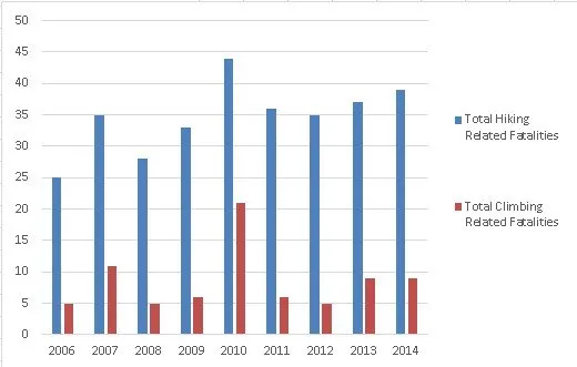
Just an FYI, but it really doesn’t help when you edit the original post where you made the comment hours later to change the percentage. Anyway I’m not really sure what talking about when you say it’s per participant per year. The article you linked to has a graphic that displays the total numbers of fatalities per year and it’s literally the number of people that have. Not how many have died as a preparation of overall hikers or per whatever thousand. Just the number of fatalities and you can’t judge how deadly one activity is compared to another that way. For instance 9 climbing deaths in 2014 versus 39 hiking deaths in that chart doesn’t factor in that millions of people went hiking in national parks that year versus like 10% of that many if even going climbing. Of course there’s going to be more hiking deaths because there’s exponentially more people hiking then rock climbing. That doesn’t make it more dangerous though.
Yeah but that’s on the extreme high end. The lower end is 0.00023 per 1,000, which wouldn’t be worse and is essentially a rounding error regardless. So be my guest and toss the climbing thing out of this. It still doesn’t negate the fact that hiking is essentially a benign activity that no one really dies from.
Fully agree with your stance on subject, still want to mention, from the point of view of a location that is a tourist destination with incoming people with differing ablities; Where there is only little wilderness, and the visibility of 90+% of trails is good=excellent for somebody out in the wilderness for days on one go, i.e. people who often will find deer tracks not meant for human traffic of good if not excellent visibility, the difference between excellent and good might better be judged from another PoV?
I described that as good in my post, and it’s a useful example of how just relying on surface etc doesn’t replace visibility, as it is less visible than many surface=compacted trails in that thread that would clearly be described as excellent.
That’s because… the trail isn’t actually overgrown.
There’s very little vegetation on it compared to the surrounding terrain, and what vegetation is there is obviously far younger than the surroundings. It’s an abandoned trail not shown on official maps anymore with some twigs on it that gets light year round traffic.
This makes a lot of sense to me (and mirrors some of my thoughts in the previous thread). The “mental load” model vs plodding is a very useful way of looking at it. I think the first example would only be excellent as things stand. As defined the second and third would overlap from good to intermediate, and then the last would include bad, horrible, and no.
The “can just plod along looking at their feet or chatting without wondering if they are still on “the trail” or not” and " A key distinction is that losing the path is possible for novices and there is some mental load of looking ahead for those not familiar with the path" feel pretty perfect.
The third seems harder to define clearly - it’s more of what “intermediate” should be IMO. As of now intermediate and bad are essentially the same rating (mostly visible vs sometimes invisible) but this makes sense to me.
The fourth should include trails that “come and go” it reads now that it’s essentially entirely pathless. On the other hand there’s a IMO strong case to be made for breaking these segments into a true visibility=no, and having visbilities above that separate segments, but that’s another thread I’ve been toying with making.
I think it’s ridiculous that in the current rating there’s one for a clearly visible continuous trail (excellent), one for a (nearly) continuous one with adequate visibility one (good), and then intermediate through no are just different proportions of “there isn’t a path”.
I think there can be regional differences in this - a novice that is used to only gravel paths might get confused by a single track dirt trail that people used to them would consider “novice friendly” in areas that mostly have compacted single track. Minor spur trails to viewpoints and water etc complicate things a little bit in terms of “plodding along”, but there’s no real risk as they can easily backtrack a hundred feet or so so the trail and continue on.
This reminds me of some quick thoughts on the trail_visibility thread referenced earlier, though I think your take on them is more nuanced and complete.
That could be difficult to do programmatically - I took a stab at that in the scramble quote up in the original post in this thread and there’s some things that overlap. I hadn’t seen the summit post conversion chart, but I’d disagree with a few takes on it - I think YDS 3 to UIAA 1 is probably sandbagging UIAA, and SAC T2 should definitely still be YDS 1, as you aren’t using hands for balance.
There would be issues converting a YDS 3 or AWTGS 5 to SAC - would it show up as 4 or 5? Someone comfortable on T4 might not mind being on T5, but you’d’ have to pick one or another, vs some osm_scale that would by definition include that range of terrain. On the downside it’d be yet another system to learn - but could be used globally as it would map to localized systems.
For roads there is a way of indicating that it is closed in winter - having some sort of way of indicating visibility by season seems appropriate. trail_visibility=horrible + trail_visibility:summer=good would be simple without breaking it into months to show late spring & early fall.
25 replies in, and it really had one on-topic comment (though there were some great points here!)
Complaints about whether trail_visibility should exist (which are coming from one vocal person) belong in the thread about trail visibility where they originated.
I’m going to rename this thread and make a duplicate of it to continue the discussion (where I would encourage people to stay on topic, this one can exist as it is here and continue on!) as I think the issue of trying to shoehorn norms is a useful one to consider with pros and cons to each side and is what people came to this topic to discuss.
If the suggestion is that a single, global visibility or difficulty key allow an annotation of the scale being used, that would all but force data consumers to normalize values into a preferred scale. As @erutan points out, the conversion could be tricky in the absence of more detailed tagging.
To the extent that the conversions are less than straightforward, it could be be useful to tag each feature with up to two keys, one according to a global scale and another according to whatever scale is signposted on the ground or otherwise locally recognized. If a mapper only knows one scale but not the other, they can omit the one they don’t know until someone familiar with the other can make their own observations. This approach would facilitate both automatic heuristics on the part of the data consumer and manual decisions on the part of the end user, albeit with a maintenance overhead as we try to keep the two keys in sync.
“Overgrown” isn’t on or off concept. It’s something that occurs along a gradient of levels. Is it the trail in image so overgrown that it’s completely invisible? no. But there’s “overgrowth” of the plants covering it. It’s not an either thing. You don’t have a completely clear, vegetation free trail one day and one that’s impossible to see or walk on the next. At least to me that would be an overgrown regardless. Not bad, but still covered in vegetation. Someone hiking definitely wouldn’t be walking on the dirt ground and if I were to ask them if the path (which again is different then the trail, but what I think people actual mean when they use the term) was visible they would probably say no. That’s kind of my point though.
I assume your talking about me. I don’t even think I’ve left the most comments in relation to this discussion. Maybe on this particular iteration of it, but I’ve barely participated in any of the conversations about trail visibility over the last 13 years. I’m certainly not the most vocal person for their side. Nor do I think I have I written the longest message, here or in any other of the other conversations. So singling me out is rather ridiculous and dismissive. It still would be even if I was particularly vocal compared to everyone else.
Also, I think complaints about how the tag should be used (I never said it shouldn’t exist BTW and I’m getting pretty sick of repeating myself about it) and in what situations were perfectly on topic to the original reason you started this. “improving” a tag can include not using it in places where it doesn’t work well just as much as it can better fleshing out certain aspects of the definition. As I’ve said multiple times now I think trail_visiblity is fine on rock paths but then it’s usefulness degrades from there. Your never going to have a global or regional consensus about something that is completely half baked though.
But regardless, acting like the only two options here are using the tag in every situation regardless of context or any other factors and it not exiting at all is a completely false dichotomy. It’s totally possible that some parts of it work well in some regions and others parts don’t. That’s fine, but your not going to have any kind of consensus either way unless the details are ironed out first. Personally, I’d probably be more supportive of the tag if the framing of the conversations around it weren’t completely bad faithed and there were more regional standards. Including not using at all in some places where it clearly doesn’t work. I don’t think that’s an unreasonable position either. Most tagging schemes don’t work perfectly in every single situation.
So, to get back on the path (excuse my pun), you’re of an a opinion that that trail_visibility=* information is worthless and beyond redemption and that people shouldn’t waste their time tagging it? So why are you wasting your time and energy here in discussion about it?
One might also happen to think that e.g. root:shape=* is too complex, subjective, impossible to tag correctly in verifiable way, and altogether useless tag (much less rest of roof:* hierarchy!) and people should not waste mapping those.
Yet guess what? According to taginfo, people do, so they seem to think that mapping those is good use of their time, even if that desire is unfathomable to others.
The same thing we have with trail_visibility=* - if one thinks is it useless and people should not waste their time mapping it, then shouldn’t they just ignore it? Because the same “uselessness” principle can be used to argue that they should not waste their time either on arguing on-and-on why they don’t see use in that tag, as it is clear from taginfo usage that other people see use of it – and such discussion is certainly even less useful that the tag itself.
TL;DR if one doesn’t care about some tag, they shouldn’t waste time following/discussing it. Now, if they do care, but think it should be improved in some some way (like clearer or more verifiable documentation on the wiki, new and improved values etc), than that is great and we should discuss it. But just “kill it, its useless” is not really productive, is it?
No. I’m just saying that I haven’t seen any evidence that trail visibility is an issue, which I think you would have gotten instead of treating me like I said it was worthless and beyond redemption since you directly quoted me saying it. BTW, you can also look through the multiple comments I’ve made here and in the other discussion where I’ve said plenty of times that I think it works well with rocky trails man_shrugging:
It’s ridiculous some people on here can’t handle even the slightest criticism or feedback about “their” tagging schemes without acting like the other side is acting like it’s completely useless and can’t be salvaged. I’ve literally said about 8 times now that I think it’s a good tag for rocky trails and the response to that has literally been people saying I think it’s completely worthless and should be gotten rid of. That’s not my position and frankly I’m tired of having to repeatedly say it isn’t.
Just an FYI for anyone reading this though in case I haven’t made it clear enough already, the tag is fine with rocky trails. I just think it could use some clarification in other areas because I hike a lot, use the tag sometimes, and there’s things I’d like to see improved about it. That’s it. The way the conversation is framed like with people acting like it’s literally a do or die situation when it obviously isn’t and the defensiveness by some people when they are disagreed with is super cringe. Does that mean I think it “worthless and beyond redemption” though, no. I’d just like be able to share my opinion without it repeatedly being mischaracterized. I don’t think that’s a hard ask either. Also, down vote the comment and flag it all you want to. It shouldn’t be that hard to not treat someone like they think a tag is total trash just because they have some issues with certain aspects of it though.
In the new text proposal, it is stated “Add the key trail_visibility=* to a way that might have visibility issues.” Is that a phrase you can live with? If not, can you propose something?
I’ll look over the propsal and send you a private message about it. I don’t want the discussion to be anymore about me and my opinions then it already has been though.
If we’re limiting trail_visbility to only ways that have visibility issues, that means that we should get rid of the excellent and probably good values. Those values are important for weight/stippling on maps as they at least indicate that there’s a good chance it is a trail worth weighting heavily / stippling thickly.
IMO there’s not any point in just limiting the key to ways that go over ground that doesn’t hold any visual impacts on the surface or have any surface construction etc, that use case can already be covered by trailblazed:visibility=*.
I’m still going to read the proposal but that sounds reasonable Maybe with the caveat that something should be done about trail_visiblity=intermediate. Although I’m not really sure what and it’s not something I care that much about anyway. I guess the usage of it around where I hike can just be dealt with somehow in absence of anything else being done to clarify or otherwise deal with it.
That’s not how I understand the proposal text. It can be added to ways that might have visibility issues, i.e. to add it to ways that a map user might be worried about having visibility issues. Tagging a way with trail_visibility=excellent then means “don’t worry” and I think that’s something a hiker/map user will appreciate knowing. The proposal also specifically states that it shouldn’t be used on paved ways because these can be assumed not to have visibility issues. For unpaved ways it’s up to the mapper to decide if it’s worth tagging trail_visibility or not.
Not to speak for Erutan but there’s going to have to be some compromises and concessions somewhere if the tag is going to ever be widely adopted. At least to me trimming a little bit of the fat to move things forward sounds a good middle ground between endlessly debating it and just ditching it in favor of something else entirely. Simple tagging schemes are always better anyway and trail_visiblity=excellent and trail_visiblity=good probably aren’t necessarily outside of acting as a way for people to fill in the map. If this is really about hiker safety like people keep saying it is then really the only tags that matter to that are the last four.
Plus, the whole thing about how trail_visiblity=excellent is for trails with no requirements is kind of nonsensical. Really, what exactly are you actually mapping there? Maybe I could understand a tag like that for say a stretch of road in the mountains where chains officially aren’t required, but a random arm chair mapper will just use it as a catch all default to fill in places that they can’t figure out a better classification for from the satellite images. Like they currently do with building=yes, shop=yes, and similar tags.
of course we do not want random users to give ratings, hotelstars are meant to be about the category (features, service, prestige etc.), although the criteria might slightly vary across regions.