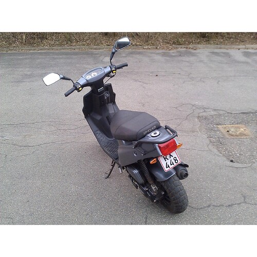
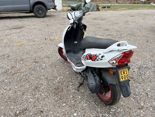
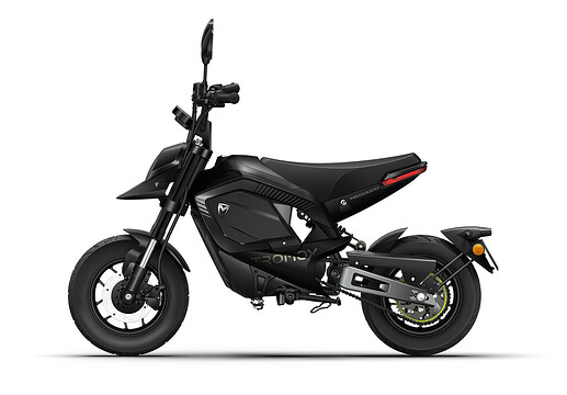
I have no idea what a mofa is, but again, let’s not overcomplicate things. It’s signed for bicycles and not cars, it’s a cycleway.
To use another potentially relevant vehicle category: a shared-use path signed as also being legal for golf carts and used by them in practice Way: Water Lilly Bridge (860258759) | OpenStreetMap
Even better, most of Ohio’s rail trails are signposted for the exclusive use of cyclists, pedestrians, and equestrians. Horses are bigger than bikes. And if you bike across Amish Country, it won’t be long before you come across a horse and buggy.
Still, no one considers them to be bridle paths or buggyways: cyclists are the main users in the public imagination, regardless of size or signs or laws or even traffic volume. It’s a real-world consensus, just the way things are. It would be difficult to capture this information outside of the primary tag, because we’d have to boil it down to a science, which it isn’t.
I get the idea but in practice, this mindset does start to slowly break down even beyond what I mentioned.
For context, there is a discussion about the tagging pure bicycle roads (i.e. one which doesn’t permit). The backstory was that this was (initially) tagged as highway=track even though this cannot be used by agricultural traffic (no exemption thereof). Said road was formally a “shared foot- and cycleway” but has been turned into a bicycle road. The main difference now is the following:
- There is an implicit speed limit (of 30 km/h) and
- Pedestrians can’t use the carriageway as a whole and have to give ways to cyclists
But in the end, its meaning is largely unchanged: It’s a cycleway which only has been signed as a designated footway because the sign for a cycleway (237) is normally exclusive in Germany.
To make it even more complex: Sign 242 (pedestrian zone) is based 239 in the middle and follows similar rules i.e all vehicles are forbidden by default and if they are permitted, they must drive at walking speed (see my previous comment and the two types of a “shared-use path”) and differences are marginal.
In contrast, sign 244 (bicycle street) is based of 237 but has one notable difference: The former is pedestrian inclusive, the latter is pedestrian exclusive and signs 240 and 241 are closer in function to it.[1]
It’s at that point where the exclusivity of cycleways got really problematic in my eyes, both in law, real-life and of course, on OSM (hence my envy to the Netherlands with their inclusive cycleways).
Of course, it gets even more complex.
I’m really questioning what the German community were thinking when this sign got introduced. The highway tagging gets a bit more complex because of different factors like who can use what. If it’s essentially a regular street (i.e. has a certain width or permits other vehicles even if only for destination traffic), it’s highway=residential/unclassified, if it permits pedestrians, it’s highway=path and if it’s bicycles only, highway=cycleway.
My problem with this one is that it throws the logic of existing tagging completely through the window since the current tagging for footways which permit bicycles is highway=footway + bicycle=yes, not highway=path + foot=designated and biycle=yes (or duck tagging if you will).
No, it’s first and foremost a way which is designated for bicycles i.e. a cycleway (just an inclusive one) and should be tagged as a highway=cycleway (bonus points that data consumers also get to know the difference between between a true “shared-use path” and an inclusive cycleway).
Even with the old signs, there are cases where highway=cycleway is more appropriate than highway=path: The “segregated foot- and cycleways” where the cycleway is much larger than that of a footway or if the footway is segregated by a kerb. In these cases, such way is really more like a bicycle street with a sidewalk attached on one side than a relative of a shared-use path (a bonus point is that you can also naturally specify the side of the footway with sidewalk=*).
Another difference is the speed limit of 30 km/h which German cycleways of either kind don’t have but that’s besides the point. ↩︎
The first half of this statement was true; the highway=path preset for shared use paths just got merged but hasn’t gone live yet:
A mofa is a small moped, with a max speed of 30 km/h. In Denmark it’s called “lille knallert” and I think its access rules are the same as in Switzerland, based on your description. A mofa is usually not bigger than a bicycle (though it is heavier), so could a shared mofa-bike-footpath not be tagged as
highway=cycleway
bicycle=designated
mofa=designated
foot=designated
Cycleways can be tagged mofa=yes to show they’re allowed.
We don’t use the term “mofa” at all in Australia.
Is it an actual motorbike, or a push-bike with a motor, either electric or petrol?
Do you have to pedal, or can you just ride, with the motor doing all the work?
All modern knallerter are pedalless, but like mopeds, they used to have pedals in the past. Most have combustion engines, but in recent years electric versions are also in use. As far as I know, the only requirement to be a legal mofa or small knallert, is that it has a max speed of 30 km/t and is physically limited to that.
We don’t use that term in Denmark either. We use the terms scooter and knallert to refer to small two-wheeled, motorised vehicles.
There are two legal categories of “Knallert”:
There is the large knallert (sometimes called the “EU-knallert” or “knallert-45”) which is equivalent to the moped key.
Details
Max speed: 45 km/h
Access: On the road.
Requirements for driving: You must be 18 years of age and have a regular driver’s license or a large knallert-driver’s license. Must wear motorcycle helmet.
License plate: Yellow plate. Always required, regardless of age.
Then there is the small knallert (or knallert-30), which is equivalent to the mofa key.
Details
Max speed: physicall restricted to 30 km/h (in theory)
Access: Only allowed on cycleways (and sharedways). If there is no cycleway, they must drive on the outer edge of the road, like a bicycle.
Requirements for driving: You must possess a separate knallert-driver’s license to drive this, which can be taken at 15 years of age. Must wear motorcycle helmet.
License plate: White plate or none at all. All knallerter built after 2006 must have a license plate, while older models are grandfathered in.
Whether something qualifies as a large knallert (moped) or a small knallert (mofa), at least in a Danish context, depends mainly on how fast it goes. Most knallerter are sold in both variants with a physical speed limiter being the only thing that makes one of them a small knallert.
It is not unheard of for young people remove the inhibitor; so while mofas in theory are restricted to 30 km/t, in practice they are not always, or even most of the time.
Sidenote: E-bikes are legally cyclists, despite being quite similar to electric small knallerter
it is a Motorfahrrad, i.e. a bicycle with an auxiliary motor, in Germany this is a vehicle class, 25ccm and not faster than 25km/h IIRR, these are not popular any more but have been in the 1970ies and 80ies, you did not need a driving license (unlike the 50ccm small scooters and moped) and they were available from 15 years on.
Ah, so that’s what mofa stands for. Interestingly, Wikimedia Commons categorizes that particular model as a moped. But maybe it would be accurate to describe it as a subclass of motorized bicycle, which in turn is a subclass of moped (but not to be confused with electric bicycle). Things always get more complicated when we start talking about engine capacities and maximum speeds. Each jurisdiction has a slightly different vehicle classification standard, making vehicle classification a fairly poor standard on which to base way classification using globally relevant primary tags.
Here in California, we have signs for neighborhood electric vehicles, a vehicle classification specific to the U.S. While I took the liberty of coining and documenting nev=*, I’m not sure I would go as far as naming a new primary tag after this vehicle classification. At most it would be a cart path, putting more focus on the general form factor or mode of transportation.
There are two classes of e-bikes. The first one has motor-support up to 25km/h the second has motor-support up to 40km/h.
In Switzerland the first one is by law a bicycle and the second one is a mofa.
To make things more complicated. There are electric mofa-like rollers without pedals. If they have a max.speed of 20km/h they are bicycles by law. If they are faster, they are mofas.
The only new class (apart from path, because that what this topic is about?) we’d need to introduce in Austria would be cycleway ![]() What in commerce is called a variant of E-Scooter or Cargobike legally here are bicycles. The number of wheels/tracks is no issue at all. Maximum motorized peed 25 km/h seemingly the only criterion. (Overall width or distance between axles affects interpretation of mandatory signs only.) Our traffic code does not know the term Mofa.
What in commerce is called a variant of E-Scooter or Cargobike legally here are bicycles. The number of wheels/tracks is no issue at all. Maximum motorized peed 25 km/h seemingly the only criterion. (Overall width or distance between axles affects interpretation of mandatory signs only.) Our traffic code does not know the term Mofa.
The more popular these Electric Light Vehicles get, the more people have gripes about them using cycleways. Some argue to ban them, some argue to make the cycleways wider. Apart from a lame joke no idea how solving these real-world problems might help in solving the issues this topic about.
That is good description! But a big issue is: there a missing category below pedestrian, i.e.:
car > bicycle > pedestrian > HurdleHeroes [1]
IOW, there needs to be a category beyond even a pedestrian-oriented highway=path, on which an average human, without experience, training or special equipment should not be lead to (nor would they want to be lead to), as they are likely to get stuck and likely put their health and even life in serious danger.
But where Hurdle Heroes can still pass.
That would include everything requiring using hands in addition to feet (e.g. scramble), or requiring special equipment (e.g. overknee-boots for getting over those long fords, machete for widening that overgrown forest trail to make it passable, or ropes and ice axes and crampons for alpinists, etc.)
Once upon a time highway=demanding_path was suggested (with extra tag demanding_path=* detailing why in particular it isn’t regular garden path suitable for stroll in a park, in addition to all the other applicable tags like sac_scale, mtb:scale, trail_visibility, etc. )
By default that new tag would not be shown on general maps (which is a good thing!), so it specialty maps (like alpine hiking maps) would need to support is separately.
The benefit is great: those maps and data consumers which do not explicitly support it because that is their whole reason of existence (which will inevitable turn to be at least 95%+ of the maps) would not be showing those and putting people lives in danger. While those few that do require those will have both a way to specify generically problematic path (i.e. only highway=demanding_path) as well as specifying details (i.e. highway=demanding_path + demanding_path=* + other tags)
Yeah, that is by far the absolutely hugely biggest one!
I argued that it needs a separate tag value as that is the only way it could reasonable work. (and we have an example of such approach working: highway=via_ferrata - the only issue being that it is very specific one, and there is a need for more generic approach)
Because there is no way to even count zillions (past, existing and future ones) data consumers, much less to tell all of them (or provide PRs!) “by the way, this new tag, if used in addition to highway=path, makes this tiny percentage of paths not usable as a path for pedestrians” - so just adding a tag can’t work.
(Even long-standing tags like access=no and foot=no are not followed by 100% data consumers… imagine a chances of a newcomer tag)
The name itself does not matter much, but suggestions are welcome - if people prefer highway=terrain_titans_only to highway=demanding_trail or whatever, it is open to discussion.
Alternative names might include Terrain Titans, Obstacle Overcomers, Challenge Champions, Adversity Avengers, Difficulties Defeaters, Quagmire Quashers, Maneuvering Maestros, etc. ↩︎
I started to use abandoned:highway=path at times, where I thought, well, certainly, people stray there, but there is no path, not even close to the OSM sense (2m wide paved for most consumers.) Not an OSMAnd user, I knew that OSMAnd can be made to show them. Recently I found that geo.dianacht.de shows them too, and I very much like the signature: It looks like the prints of boots in the dirt ![]()
When something is very fresh, I sometimes prefix with proposed: So to say, some people would like a path to emerge there. With enough of uptake – not in the sense of getting paved though – this can turn into a regular path, time will tell! (Thinking over it, informal: prefix might be another choice?)
I am not sure exactly what an abandoned path is. I could understand abandoned:highway=residential + highway=path to describe an abandoned road that’s now a path. But you can’t get less highway than a path. Does abandoned mean “overgrown”? “underutilized”? “access prohibited”? I cannot think of a case where another tagging woudn’t be more appropriate.
I believe it means abandoned in the sense of railway=abandoned: someone found a boot stuck in the mud somewhere along it, possibly with the help of aerial imagery, and will make sure you know about it if you dare to delete the way. ![]()
Kidding aside, abandoned:highway=path reminds me of the Alamere Falls Trail, which at one point was unquestionably a highway=path but was later abandoned by the maintainer and had its trailhead sign deliberately removed in order to keep people from following it. That said, I don’t think that describes every case where highway=path feels like a stretch.
I locally use abandoned:highway=path + obstacle=* to mark trails that are no longer maintained or used, often due to obstacles like landslides or fallen trees. These paths typically become overgrown and impossible to follow. In most cases, a new, usable trail segment exists nearby, so I find it important to guide users toward the safer route. Occasionally, after several years, an abandoned path may be reclaimed and restored, at which point it can be upgraded again.
Funny you mention this: I tagged abandoned=yes on a path where the local rambling association put up signs “abandoned trail, do not use”, only to learn a bit later that those got armchair mechanically retagged abandoned:highway=path because that is "just another way to tell the same." So the next time I paid visit to a PoI that went into oblivion and the fingers of one hand enough to count the visitors per year, where openstreetmap had no path leading there, I thought, well this is much less of a path than the other, so I just obey in advance. Rest assured, 999 of 1000 hikers passing by will not notice the “path”, 99 out of 100 I dare bet not even when told to look for it when not given clues to its whereabouts with better than GPS precision and will instead find 50 other “paths” leading nowhere ![]()
Paths are just an idea, ideas never die. And if not a single person on Earth carries the idea, it will still continue to live in the Heavens for all of eternity. So that is why I prefer prefixing over deleting. At least as long the path is still in administrative GIS ![]() I restored some of those that got deleted by overzealous openstreetmap contributors (erm, what is the contrary of contribute?), a bit under the rationale, to keep armchair mappers at bay.
I restored some of those that got deleted by overzealous openstreetmap contributors (erm, what is the contrary of contribute?), a bit under the rationale, to keep armchair mappers at bay.
I am not sure exactly what an abandoned path is. I could understand
abandoned:highway=residential+highway=pathto describe an abandoned road that’s now a path. But you can’t get lesshighwaythan apath. Does abandoned mean “overgrown”? “underutilized”? “access prohibited”?
for example when a path gets interrupted by a landslide or rockfall, it will often still be recognizable for a few years but will not be used or usable (or at least used much less) because of the interruption
Related discussion how to map snowmobile “paths”, which share some of the issues (e.g. not precisely clear-cut) is at Snowmobile feature type needed, one of suggestions was piste:type=* and related tags for that case.


