I suspect that the background maps are those used in the Analysis function of KPN, which is aimed at node networks. There is no monitored node network in Switzerland or Italy.
1 Like
That’s really great! ![]()
I did a bit of check of the EV5 because it’s the one through my home region.
Segments seems to me relevant, especially between two parts.
With the GPX it should be easy to identify (and fix such errors) as between
EuroVelo 5 - Via Romea Francigena - partie France 2 and EuroVelo 5 - Via Romea Francigena - part Germany 2, where I suspect that the German part should begin where the French part ends.
The last time I was cycling in this part, I didn’t pay attention to EV5 signs. But it’s still an ongoing process that stickers will be replaced with signs here,

the left one is new, the right one is old.
2 Likes
Well, I did a check with the GPX-file from Cycling tourism: Via Romea (Francigena) cycle route - EuroVelo - EuroVelo and was a bit surprised:
There’s a gap between Luxembourg City and Schengen
The second french part is missing because of differences of the GPX-track and the routes, the GPX track doesn’t touch France but is completely in Germany:
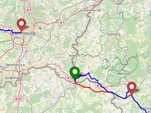
Blue: GPX-track that I’ve downloaded, red the route as mapped in OSM and the tool.
Either it was an outdated gpx track or there’s work on the gpx tracks too.
Along the gpx track I found some other errors of the track too.
Maybe it would make sense to split the GPX files into the parts at <trk></trk>
<trk>
	<name>01: Canterbury – Dover (Developed)</name>
	<desc>Developed</desc>
	<trkseg>
	</trkseg>
</trk>
<trk>
	<name>02: Calais – Ardres (Developed with signs)</name>
	<desc>Developed with signs</desc>
	<trkseg>
	</trkseg>
</trk>
<trk>
	<name>03: Wardrecques – Saint-Venant (Developed)</name>
	<desc>Developed</desc>
	<trkseg>
46 parts for EV5.
I can see the gap in the GPX and that Schengen - Sarreguemines is only marked as Developed not as Developed with signs
<name>16: Martelange – Luxembourg City (Developed with signs)</name>
<desc>Developed with signs</desc>
...
<name>17: Schengen – Sarreguemines (Developed)</name>
<desc>Developed</desc>
...
<name>18: Sarreguemines – Gondrexange (Developed with signs)</name>
<desc>Developed with signs</desc>
2 Likes
But then it would make sense, or even be required, to split the OSM relations at the same points don’t you think?
Principially yes, but …
I’ve published my local html file on my free webspace. It will be easier to look at the GPX then.
I hope that’s ok with the license of the GPX file that I didn’t look up. If it’s not I will remove this page.
https://leaflet-examples.4lima.de/ev5.html
You will see that there’s most times an overlap between end point (red marker) of one part and start point of the next part (green marker). I thing that shouldn’t present a problem.
But there’s at least one problematic point even in current relations: Martelange Belgium and Martelange-Rombach Luxembourg. Knoppuntnet marks rightly a difference between start and end point of the route relations.
There are two one-way-streets to cross the border and I think it would be better, if this small part would be in one relation with forward and backward role. But I’m no expert in relations.
This is a question to all about how to collaborate best.
I wanted to ask a technical question about splitting GPX files, but I told myself it was going to pollute the thread, which so far is fairly well focused on improving EV routes. Asking elsewhere would be an option, but we would lose what pilots call “the party line” (hearing what the others are saying, to get situational awareness).
Another option, which has worked fairly well for working on outdoors routes in France, is to create a dedicated Telegram+Matrix channel, have short-lived detailed discussions on that channel, and come back to the forum with more synthetic / general messages.
What do you think? If you think this is a good idea, would Telegram+Matrix be OK? What about the title? It might be useful to aim a little high, ie EuroRoutes so as to include hiking E-paths and other international outdoors routes.
1 Like
Do we agree that removing overlapping sections in the EuroVelo GPX files would be desirable?
If yes, we could work keeping that in mind and we could:
- have the same segments in OSM as in the GPX file, choosing the cutting point arbitrarily in OSM where necessary;
- avoid overlapping in OSM;
- using the deviations that this creates in KPN to show how the EuroVelo GPX traces could be improved
JOSM is actually not bad for this, just import the gpx, right click on the layer: “convert as data layer”,
then delete everything you do not want and re-save as gpx (or split and copy to
different layers which you then save as gpx).
1 Like
My opinion: it would be better not to have overlapping sections.
But please remember that we probably need two GPX files for each section, one for each direction. There’s the problem with one way streets i.e. at Arzviller
By the way I’m surprised at the work done these last hours. There were some problems at the german part of EV 3 but that’s fixed now and one part of EV5 where GPX is wrong and OSM is right is now a separate section, at Gondrexange. You won’t cycle on the left side of the Canal du Marne au Rhin there

even if with some types of bicycle it won’t be easy to cross the bridge over the canal:

1 Like
I have explored a bit further the idea of splitting the OSM relations at the same points as the EuroVelo GPX traces:
-
KPN Monitor gives the ability to upload a GPX reference for each sub-relation, see below at the right of the image.
-
the GPX file for EV4 contains 108 parts, which look like stages (from city to city) and do not match country boundaries exactly. It may or may not be a problem for us. In any case, this will require a significant amount of work if want to split the OSM relations into the same number of parts.
The only process I can imagine if we would like do to this would be 1) to split the relation according to the GPX parts, 2) recreate a monitor in KPN, 3) upload the individual GPX parts to KPN.
1 Like
The first german relation part (border - Köln) https://www.openstreetmap.org/relation/2793464#map=16/50.9351/6.9737 contains a bit (on the right side of the Rhine) that belongs to the second part (Köln - Koblenz) https://www.openstreetmap.org/relation/16742758#map=16/50.9330/6.9739, where it is missing. It would be great if a relation expert could fix that problem.
It is done. Hopefully.
Apparently there are ordering issues in the second part, but I’m weary of using the auto-ordering function of JOSM when there are forward/backward roles.
1 Like
Thank you very much!
I can understand that very well. I did some reordering by hand between Deutzer Brücke and Alfred-Schütte-Allee. Both directions have the forward role to get the right order. Is that right. Additionally I added to one element the forward order.
I think the sorting algorithm now handles the forward/backward roles correctly, if all the ways are there and have the correct roles regarding the way direction. If there are many interruptions the sort will not produce the expected result. It’s best to test this with short bicycle routes, which allow you to check the results.
Still, even with the sort function, it is hard to maintain long relations.
I don’t know any sort function that can order child relations within a parent relation.
Well there’s the reverse process too:
- Combine the parts of the GPX file without gaps.
- Split the GPX file according to the relations
- Recreate a monitor in KPN
- Upload the individual GPX parts to KPN
It’s one step more but splitting and combining a GPX file is IMHO easier and less error prone than splitting relations.
I struggle to find the right word, but there is some sort of practical ethics that has been drilled into the French outdoors group by those of us who work for route operators: try and respect the editorial choices of the route designers, and treat them as part of the reality we are mapping. Of course, physical reality trumps editorial choices, but our own choices should come last.
@Florange_Grimoire will need to confirm, but if ECA selected these stages, it might be worth using them in OSM.
2 Likes
Of course, that makes sense and I didn’t thought of that.
I have, as an experiment, split the first four or five sections of the EV4 route according to the stages in the EuroVelo GPX. Then I have created the EV4-gpx monitor with a multi-gpx reference, then uploaded GPX traces for the first three sections. Here is the result:


2 Likes
I am happy to provide connections / promote any discussions for Ireland - board member for OpenStreetMap Ireland and a member of the Dublin/Cork Cycling campaigns. ![]()
1 Like