Hi, thanks for your offer, it would be great if you can create monitors for all EuroVelo routes in Knooppuntnet! It would help to list all the problematic parts and go about fixing them. I can put everything you need together and send it to you next week.
Just to be sure I understand everything, and all the potential of this tool, could you direct me to a page/document explaining the functionality? The DEMO videos seem to be more for using the route planner tool than about the comparison tool, unless I’m wrong?
And regarding the little experiment that you already did, did you use the tracks from www.EuroVelo1.com to make the comparison with OSM tracks or not? (I can send you the full route tracks in better quality, though there are always imprecise bits here and there). If not, how do you spot the routing issues - do you mean the relations that are just a few nodes, or where we see loops?
So please confirm what you would need for this: relation of each EuroVelo route + official tracks to compare OSM tracks to?
And for relations that are too big such as EuroVelo 4, I guess the best is to do cut them? But it could become quite a long work then.
Anyway, let’s go one step at a time Thanks for your help!
It’s best to work with examples, currently. If you look at the EV1 example you see first that I have chosen an “OSM reference” and not a GPX reference".
OSM reference compares the geometry of the route captured at a given date with its current geometry. As explained by Peter in another thread, it is useful for route operators who want to see if improvements made to OSM should be ported back to their own reference data.
GPX reference compares the route with a GPX file that has been uploaded. It helps for instance when creating the route in OSM or when the data provided by the operator changes.
I have chosen “OSM reference”, because it was faster for me. It means that we start with 0 deviation reported, and that deviations are not a relevant information. What is relevant is the number of segments and the maps of segments because that is where you see discontinuities (and also bugs in KPN, which are already known)
I have worked on the documentation of Knooppuntnet Planner and Knooppuntnet Analysis, here.
I guess this wiki page should get another tab for Knooppuntnet Monitor. Problem is that I have not been involved in the creation of Knooppuntnet Monitor, so I basically have to find out how it works, just as any of you, and I am currently working on other projects.
Not that much work if done properly with JOSM. The point is that:
the OSM culture tends to favor changes made by local contributors. It protects us from overenthusiastic contributors who want to “standardize” or “normalize” things, or who work based on dubious data sources, without any kind of control by a “well-informed community”. If we decide that “we Europeans” are the locals for E-paths and EV routes, and that any of us should feel free to make changes in other countries, then the working group needs somehow to become the well-informed community in question.
a number of questions are open as how to organize long routes, their stages and their alternative sections. A proposal has been put forward by Nadjita, that definitely constitutes a useful basis but requires additional points of view to be considered mature.
I wrote this about hiking route relations; cycle route relations are broadly similar in OSM (with the obvious caveat, already mentioned, that you’re more likely to have parallel oneway sections on a cycle route than a hiking route).
I have started the work of segmenting EV4-Germany into segments of roughly 500 members joining large cities. My work is not committed yet to OSM. When I commit, it will need review.
With large relations of any sort, I’d actually suggest “committing as you go”, as constituent ways can easily get split all the time, which would require you to reconcile your changes with whatever else has happened…
as soon as Florence sends me the traces and I’ve tried to add the routes. A few of them may end up being too large like EV4 and someone may need to split them before we can add them.
I found that the GPX files are available on the EuroVelo site, but that KPN seems to have difficulties to handle them. In order to avoid overloading the server, I will stick to OSM references until the KPN developer tells me it’s OK to switch to GPX references.
Consequently, I am adding all the EV routes now. It should be done or nearly done when you read this message.
I suspect that the background maps are those used in the Analysis function of KPN, which is aimed at node networks. There is no monitored node network in Switzerland or Italy.
The last time I was cycling in this part, I didn’t pay attention to EV5 signs. But it’s still an ongoing process that stickers will be replaced with signs here,
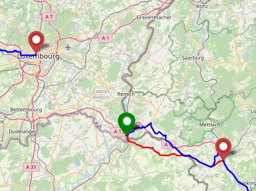
There’s a gap between Luxembourg City and Schengen
The second french part is missing because of differences of the GPX-track and the routes, the GPX track doesn’t touch France but is completely in Germany:
Blue: GPX-track that I’ve downloaded, red the route as mapped in OSM and the tool.
Either it was an outdated gpx track or there’s work on the gpx tracks too.
Along the gpx track I found some other errors of the track too.