I think “wash” feels more natural, but that may be just my biased opinion.
If I can put up with place=neighboroughood, I can deal with natural=wadi.
I think “wash” feels more natural, but that may be just my biased opinion.
If I can put up with place=neighboroughood, I can deal with natural=wadi.
The wikipedia article on wadi seems to imply the valley rather than an ephemeral water course that is often but not always in a well defined valley.
Last time we deprecated the term “wadi” was because it was perceived as local term and not suitable to use globally.
A link to that discussion would be helpful - my recollection was that a number of people thought** that it added no extra value over intermittent
** I didn’t agree, but it didn’t affect what I mapped as deserts are rare in England ![]()
I don’t have the exact link to this discussion, but here are some links to past discussions about this topic:
https://lists.openstreetmap.org/pipermail/tagging/2014-August/019027.html
https://lists.openstreetmap.org/pipermail/tagging/2015-January/020946.html
https://lists.openstreetmap.org/pipermail/tagging/2015-September/026692.html
https://lists.openstreetmap.org/pipermail/tagging/2016-September/030016.html
Some resources for differentiating a wadi vs wash
World Atlas - wadi
World Atlas - Major wadis of Egypt
AZ Central - wash, arroyo, gulch
Wiktionary - wash
I did a search on wadi within OSM communities and came across this discussion years ago in the Israel forum: Rivers, Wadi, width ?
Since then waterway=wadi got deprecated as noted earlier in the case of linear features to waterway=stream|river; intermittent=yes.
Areas are still an issue which leads me to…
Wadi can indicate the portion in a confined valley and also continue to semi-confined sections or even out in a broad plain where subtle topography affects the course of the waterway(s) when flowing.
I like wadi for several reasons since it works well as a scalable area. I have mapped intermittent streams (waterway) connecting to intermittent rivers (waterway) which then broaden into a broad confined area (area=wadi & main channel waterway=river; intermittent=yes) which broadens further into a semi-confined area (still a wadi + waterways) to either a shoreline of a large water body (Persian/Arabian Gulf) or a terminus where the water budget of inflow<<(evaporation + absorption) results in a small (unnamed) or large (named) wadi.
Wadi Rum
Oman where Salalah escarpment directs flow from the highlands to The Empty Quarter
After Wadi was deprecated I’m using waterway=river/stream with intermittent=yes and I’m very content with it. As a remote mapper in the area of the Horn of Africa (see e.g. here) I don’t have the knowledge to distinguish different grades of intermittency.
Also, I like that waterway=river/stream + intermittent is a neutral term for dry rivers locally called wash/arroyo/wadi and probably many other local terms.
If one would change something for dry rivers I would plead for waterway=dry_river/dry_stream or natural=dry_river/dry_stream (analogous to dry_lake) with the optional tag intermittent to define the frequency of water flow.
I think all the references make it clear that “wadi” and “wash” really mean the same thing (although “arroyo” has other issues). Especially the link to Oman where Salalah escarpment directs flow from the highlands to The Empty Quarter, which is indistinguishable from an aerial picture from the US Southwest. Here’s what that looks like:
The most recently active channels are a lighter color and the older/abandoned channels are slightly darker. I don’t know if the processes are the same, but I would guess that the coloring in Oman is the result of accumulated desert varnish, the same as in the US. The banks on either side are clear and distinct.
There’s not much vegetation out there at all, but if you zoom in you can see that there is some scrub in the wadi, primarily at the margins of the active channels. And there’s little to no visible vegetation in the higher ground outside the wadi.
I would map that with a linear way tagged with waterway=river + intermittent=yes through whatever looks like the most recently active channel, but with the expectation that this way is an approximation that could be wrong each time the wadi floods.
Then, I would map the area between the banks as natural=wadi and hope that someday the renderers would do a good job of drawing that. Eventually, we would need a rendering that would be distinct from natural=sand, natural=bare_rock, or natural=ground.
For the area features we’re talking about I am preferring the tag natural=wadi over natural=wash for a few reasons:
wash is more likely to be mistranslated from English into something to do with cleaning in other languages (e.g. “lavar” in Spanish). I’ve not tried the auto-translate in these forums, but Google translate messes this up.
wadi is easier to search for. Googling for “wadi” brings up results related to the landform. Googling “wash” on the other hand brings up hundreds of results for a variety of things that aren’t the land-form – everything from laundry to hair to sanitation.
wadi is used in a wider swath of the world across at least north Africa and the middle east, whereas wash is only used in American English in the south west US region.
As someone from the very wet US north east I wouldn’t know what a “wash” was without having traveled to the south west. Without significant context most American English speakers would not identify the term.
I voted for wash, but If we had more choices and ranked choice voting, I would rank it third behind dry_watercourse, and dry_wash.
It’s interesting to keep in mind that what brought this up was a bunch of NHD washes in the Rockies, which are more of a gulch than a wash or a wadi.
That’s why I like dry_watercourse since it’s more generic and not a localized term.
Creating an OSM specific term is kinda nice because it avoids various regionalisms and we can make it what we want… it’s less nice because it’s less intuitive and discoverable. I would support one for sure but alas nothing is free.
Actually, your post in the river topology thread was just a catalyst to get me to write up something that has been bugging me for a long time. I run into all sorts of odd tagging for these features in the desert southwest – as you can see from the examples in the first post.
With the additional discussion, it looks like natural=wadi is coming out on top, leading by 8 to 5 at the moment.
As I understand it, we are pretty much at:
waterway=stream | river with intermittent=yesnatural=wadiWhat is the current procedure to formalize this? I assume it is still to have a proposal page on the wiki that is then voted on.
I guess we either need a proposal or enough organic usage of the tag for it to qualify to be documented as “de facto” on the wiki.
… and possibly a “proof of concept” map in some format that shows them?
I have put a polygon around “Big Wash" near Oro Valley, Arizona with natural=wadi on the tag. Once the extracts for this area get published, I will down load them and update my map rendering to show natural=wadi the same as I show an area of sand. Probably not ideal but a fairly easy change to my style information.
For what it is worth, Big Wash drains into the Cañada del Oro wash which has been previously tagged with natural=river, intermittent=yes and water=river so you can see the difference in how I render that. My rendering is quite different than the usual OSM but it might be useful.
How the wadi changes over the years ESRI wayback
On the left, draw mouse over dates.
A side note.
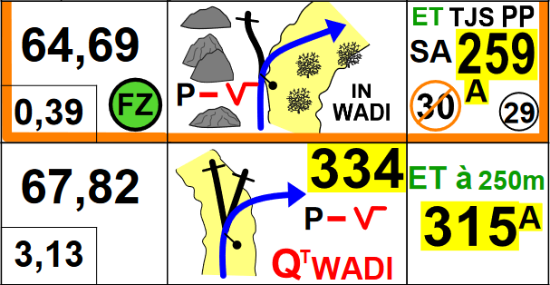
In cross country rally “wadi” is also used in roadbook tulips. FIM lexicon page 107 FIA page 101
Settting out a stage, survey is the important part.
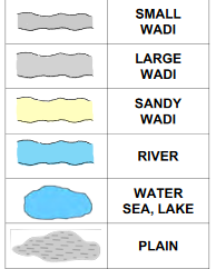
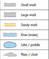
Hmmm. That map key distinguishes between a wadi and an sandy wadi. I guess we can do that with a surface=* tag. I don’t see how that would conflict with a top level natural=wadi tag.
In the paste the used paper roadbooks in black and white.
Now they start using color and tablets.
It is then only the color yellow that changes for small and large wadi when it is sandy.
