Place classification - town vs suburb, remote rural areas, how does a CDP relate to place

Indeed, this National Geographic political wall map of the world shows Ely hanging out there by itself:

On the other hand, this globe only 6 inches in diameter omits Ely in favor of the bustling metropolises of Burns, Oregon (population 2,730), and International Falls, Minnesota (5,802):

Every map aims for a different density of place labels. A globe or wall map generally aims for greater density than an interactive digital map or the index page of an atlas. A binary choice between place=town and place=city can’t possibly accommodate this range of needs. A print cartographer would have to consider place=town along with place=city, prioritizing the latter over the former in case of a collision. Conversely, many place=city nodes would need to be omitted for lack of space. This decision is influenced by the projection and typeface as much as on-the-ground considerations.

In my opinion, the OMB core-based statistical areas offer a more deterministic, if imperfect, starting point for deciding which places quality for place=city and can have a surrounding ring of loosely subordinate place=town nodes.

We’re drifting off topic here from rural Nevada, but I’ll point out while I see how this view has some merit, it is not the mapped consensus in OSM. From a quick look on overpass, I count 29 place=city in the “Los Angeles-Long Beach-Anaheim MSA” (i.e. Los Angeles and Orange counties), encompassing roughly every incorporated municipality with a population over 80k or so. Most of ones I spot checked have been place=city for over a decade without ever being changed. I quickly looked at some other major US metro areas and the places typically tagged as city appear to be similar: major suburbs (American-definition) over 100k population are almost always place=city, indicating a prevailing definition much closer to the OMB Principal Cities than the ones in the MSA name.

It’s true that this hasn’t been the prevailing practice on the coasts, although at various points in OSM’s history, it has been common away from the coasts. Around me, historically, even non-principal cities were tagged as place=city just because the San Francisco Peninsula has been home to many large incorporated cities arrayed along the coast rather than ringing a central city. The Southern California coast has similar patterns of development. But these places have also been a frequent source of negative feedback from cartographers, because it’s just… loud compared to other parts of the country. And then there’s New England.

As with highway classifications, if we want to rationalize place classification at all, we need to be willing to buck some regional practices that became entrenched by default after the possibly informal decisions of a few mappers when the community was much smaller. It isn’t a decision to be taken lightly. Or we can decide not to attempt more balance between dense and sparse regions of the country, but that would probably be an unsatisfying outcome for the participants of this particular discussion.

2 Likes

To put a finer point on it, if we boil down the definitions of principal cities, urban clusters, micropolitan areas, and so forth, what this really means is the following definition of place=city:

A city is any incorporated place or CDP with over 10,000 residents, but only if it is an anchor city of a metropolitan area or a suburb of a larger city. An incorporated place of between 10,000 and 50,000 that isn’t a suburb would be place=town, regardless of density or geographical prominence.

The preference for suburbia would clearly depart from most mappers’ and data consumers’ expectations. Some regions apparently follow this definition today, deliberately or accidentally, but I think this is no more usable than the regions where every legally designated city has been promoted to place=city.

2 Likes

I’m not sure I follow. Can you point me to a region of the US where place=city is not defined roughly as “suburbs” >80k or so in population that are nonetheless not one of the couple of principal cities in the metro area? I can only find locations that do seem to conform to roughly that guideline: Node: ‪Santa Monica‬ (‪1792515162‬) | OpenStreetMap, Node: ‪Peoria‬ (‪1340670207‬) | OpenStreetMap, Node: ‪Thornton‬ (‪151412991‬) | OpenStreetMap, Node: ‪Independence‬ (‪151407399‬) | OpenStreetMap, Node: ‪Gary‬ (‪153543923‬) | OpenStreetMap, Node: ‪Irving‬ (‪4400006133‬) | OpenStreetMap, Node: ‪Marietta‬ (‪2548821609‬) | OpenStreetMap, Node: ‪Bethesda‬ (‪158248181‬) | OpenStreetMap, Node: ‪Elizabeth‬ (‪158814887‬) | OpenStreetMap, Node: ‪Lynn‬ (‪158822289‬) | OpenStreetMap, Node: ‪Pontiac‬ (‪154148875‬) | OpenStreetMap

I can’t vouch that all of these are correct, and some of them have indeed toggled over the years, but in general I guess I don’t see what is so different between California/the coasts and other parts of the country? It seems like tagging these sorts of places as cities is a fairly reliable nationwide practice, and all of these regions also tag smaller suburban settlements as towns.

Can you clarify what you mean by “the preference for suburbia”? As in, classifying “major suburbs” as place=city? Or do you mean not classifying small (pop < 50k), isolated places as place=city? I’m a little mixed up by your definition here as well, it looks like it claims that an incorporated place that is the center of a metropolitan area between 10 and 50k is both a city and a town, and that one that’s not the central place is always a city? I think it’s quite the opposite right now in the database: the prevailing bar for places tagged city in major metro areas is higher than in more rural regions, more like 80k people, at least where I checked (counter examples welcome). If it was 10k, the LA basin would have a lot more than 29 cities, for example. So I don’t think any region currently follows the above definition.

In general, I am fine with tagging relatively small isolated settlements as place=city if they’re very important regionally, as long as they have some minimum of “major” services available (spitballing but, hospital, movie theater, multiple neighborhoods/major retail districts, etc? But towns probably have these in some regions too). Maybe a rule of thumb could be, is it a highway=trunk destination? :wink: I also agree that what a local government defines itself as/whether one exists is almost always irrelevant to what OSM place tagging somewhere should have.

But I do think there’s room for many large “suburbs” to be tagged as cities in major metro areas. Taking LA as the extreme example of a decentralized urban area, I guess I just don’t see how retagging Santa Monica (population 90,000) or Pasadena (population 130,000) as towns, the same as El Segundo (population 16,000) but differently than Glendale (population 200,000), is objectively better/more useful/more in line with someone’s expectations than current practice.

No, I’m saying that principal cities are not the determining factor in how mappers have decided between city and town – and you’re helping to demonstrate this point, because the cutoff for a principal city is 10,000, not 80,000. The cities that form the name of an MSA are better candidates for place=city than the other principal cities, and better candidates than the principal cities of a μSA.

I’m also asserting that some regions have a tendency to promote more cities to city than others. The affinity for city is not strictly a coastal versus inland phenomenon; I was generalizing. Rather, the way it normally plays out is:

  1. The GNIS and TIGER imports classify places with a population under 100,000 as town and over 100,000 as city.
  2. Some borderline places are reclassified, still generally adhering to the 100,000 threshold that used to be documented prominently.
  3. An inexperienced mapper is unfamiliar with OSM’s unconventional approach to place classification and proceeds to retag places en masse or haphazardly, presumably based on official designations. Depending on the state, this eliminates usage of place=village or place=town throughout the state, but generally, the map is now awash in place=city nodes at low zoom levels.
  4. In a less densely populated region, this is so jarring that more experienced mappers step in to revert the changes. Now the local community can no longer go off gut feeling and has to decide on a more rigorous rubric or reiterate the 100,000 threshold. At this point, there’s usually discussion about adding nuance beyond a rote population threshold.
    • For example, I wrote up this guide for Ohio based on the global documentation based on private discussions with other mappers in the state.
    • But the mass changes persist much longer in a more densely populated region, or in an area with few vigilant mappers.

The previously documented 100,000 threshold was very rigid, so in some regions, it ended up aligning to metropolitan areas’ core cities, while in others, it was so arbitrary that mappers ignored it.

The definition I quoted, requiring city to be a suburb, is fake. No one follows that definition. I posted that strawman argument to show how relying on the formal concept of an MSA or CSA principal city, as discussed in the original post, would be highly problematic, and it seems that you agree.

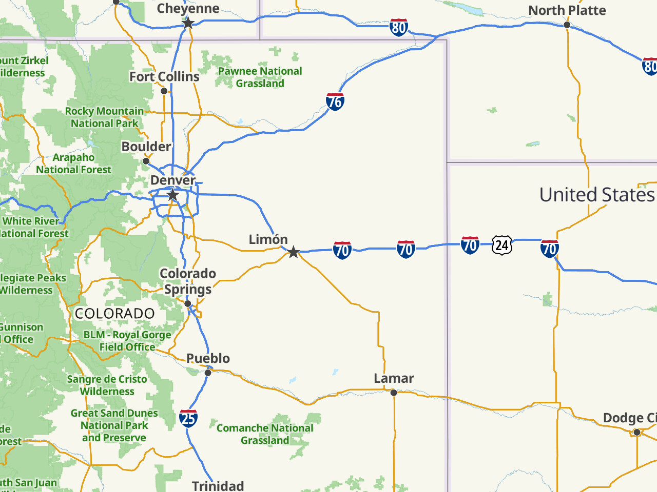
A crossroads isn’t necessarily anyone’s idea of a city. On Monday, the AARoads folks had some fun advertising Limón (population 2,043) as the new capital of Colorado, on account of its special status as the Interstate 70 control city to nowhere, a frequent topic of outrage among roadgeeks:

It’s a different approach, to be sure. There aren’t any comparable metro areas in the Midwest. Is that a problem? Only if we care about establishing a more balanced distribution of each place classification. If we don’t care about that, then why not classify places strictly on the basis of population, as we used to? The problem is that we start twisting ourselves in knots about how the population is calculated, as we did regarding New England and as an osm-carto developer once did regarding California.

If we do decide to tag place=city more selectively in the L.A. metro area, I don’t envy the challenge of picking favorites. It’d be just as difficult as picking which of the many equally built-out grid streets should really be a primary street. But we have picked a subset of streets to be primary streets in many city grids. At first, it certainly ran counter to local mappers’ intuition, but the benefit is a less extreme distribution of classifications across regions. If we take a similar approach to place classification, maybe there wouldn’t be so much pressure to tag the Limóns of this country as major cities.

Can you say more about this?

Solely talking about CDPs this time and just the nodes themselves rather than their boundaries, my biggest question would be where do you draw the line between tagging a CDP as a hamlet/village/town/city and tagging one as a neighborhood/quarter/suburb? Whether or not it has its own postal code? How notable it is to locals? How much development or infrastructure it has? Its distance to the area’s main city?

Brace yourself for my rambling: I myself live in the CDP of Leesylvania, Virginia with a population of about 22k. It does not have its own post office and is addressed to the larger nearby CDP of Woodbridge (44k pop.). Colloquially, I refer to the place I live in as either “Woodbridge” (which my home is addressed to) or “Neabsco” or “the Neabsco area” (the former name of the CDP and the name of the creek I live nearby), but when I want to be technical I will sometimes refer to where I live as “Leesylvania”. Similar to the Leesylvania situation, there’s Dale City, which has over 75% more people than the place it’s addressed to (Woodbridge) and is a far more common colloquialism around here than Leesylvania. And then there’s Lake Ridge, with about the same population as Woodbridge, and Montclair, with about half. Both are CDPs; Lake Ridge (44k pop.) is addressed to WB and Montclair (22k pop.) to the incorporated town of Dumfries (about 6k pop.). Next to Dumfries is the CDP of Triangle (about 10k pop.), the smallest of all these CDPs, however it has its own post office. Then there are also the CDPs of Cherry Hill (24k, addressed to Dumfries), Quantico Base (5k, addressed to Quantico), Independent Hill (10k, addressed to Manassas), County Center (4k, addressed to Woodbridge), and Potomac Mills (6k, also addressed to WB). “Independent Hill” and “Potomac Mills”, if I had to guess, are the most common colloquialisms here.

How would you classify these places knowing how common their names are in everyday communication, where they’re addressed to, their populations, etc.? If you were to discuss with other people how these places should be classified based on their varying characteristics, it would surely be time-consuming to identify them and their details and the discussion would obviously lead to disagreement in some way or another. If you were to set a standard, such as “all of these places are CDPs so they should be villages and towns” or “all of these places are CDPS so they should be neighborhoods and suburbs”, all the bias is eliminated and everything is straightforward and the discussion is done in that regard. However, I want to agree with the first mindset, because there are of course neighborhoods and suburbs overlapping with incorporated towns and cities as well as CDPs, but no villages or towns doing so (AFAIK). There are also no CDPs, at least in the contiguous 48 states, that overlap or exist within cities, however there are some that co-exist with counties (like Arlington, VA) and some that span other address cities (such as Moapa Valley, NV, addressed to either Logandale or Overton). Not to mention, CDPs are federally recognized while the majority of existing places tagged as neighborhoods, suburbs, and such are just loosely-defined areas with a common name.

I have been withholding my addition/reclassification of places to OSM based on their statuses of CDPs until there is a stronger agreement amongst the community on how to classify them. However, in conclusion, I generally maintain my stance with equating CDPs to towns/cities/equivalents—except with little to no local government and with vastly varying notability and styles of postal addressing and should use the rural place classification hierarchy of hamlet/village/town/city.

Is that really true? I think there are certainly large suburbs around some Midwestern cities. Included in my laundry list were Independence, MO outside of Kansas City, Gary, IN outside of Chicago, and Pontiac, MI outside of Detroit. Certainly Chicagoland at least has many suburbs with populations near or above 100,000.

I also guess I don’t fully understand what you mean by “establishing a more balanced distribution”. If there are more people in certain areas, surely there could be more cities, as long as a hierarchy is preserved? Urban California also has lots of towns, many more than there are cities. There are also more primary roads in denser areas than in less dense areas.

I realize this is fairly tongue-in-cheek, but I don’t think anyone is seriously advocating for Limon, CO to be a place=city just because some long-distance roads happen to intersect there and a DOT made a strange guide-sign choice, so I’m not sure I understand your point about the pressure to upgrade them. To clarify to anyone who might be unfamiliar, by “trunk destination” I mean a place designated by each state’s community as a “population center of regional importance” that trunk roads are supposed to connect in the revised US highway classification guidelines that have come about in the last few years. Which population centers qualify were also somewhat debated by the community then, including some of the remote Nevadan spots we’re discussing here IIRC.

No argument there, but did I understand your earlier point correctly that all 18 large suburbs of Los Angeles are all so significant that we need not set Los Angeles itself apart from any of them? My contention was that, looking at the big picture, only some of them warrant that special treatment, because a city of 10,000 or 80,000 or even 100,000 isn’t necessarily very remarkable in Southern California. Nor is a city of 2,000 in eastern Colorado, even if it’s the only sign of civilization for miles around. If we want a thoughtful, deliberate classification system, it should be based on the norm, not the extremes.

At the time, some of the folks involved with highway reclassification sought to use place=city cities as the nodes in the trunk network. Sooner or later, folks involved with place reclassification would seek to use highway=trunk roads as the edges in the city network. It all strikes me as a grand exercise in circular logic. Imagine having to explain these decisions to a newbie who wants to reclassify something more naïvely but can’t because of these criteria. How do these criteria not come across as a sort of bureaucratic runaround?

It was an April Fool’s in-joke for the roadgeek community, perpetrated on their fork of OSM Americana. It referred to the choice of Limon as a control city along I-70 instead of the far more recognizable Denver. Some people get worked up about illogical control cities. As it happens, Limon is listed as one of Colorado’s trunk cities because of the long-distance highways that converge there.

What counts as federal recognition? The federal government’s official gazetteer, GNIS, includes extensive coverage of places of all sorts in several feature classes. The Populated Place class includes incorporated cities, neighborhoods, and unincorporated communities alike, as well as more questionable entries like shopping centers and mobile home parks. The Civil class covers any political division, such as a county or incorporated city. The Census class covers CDPs and the like. There isn’t a strict 1:1 mapping between Populated Place and Civil, nor between Populated Place and Census.

All three classes are federally recognized in the sense that the federal government acknowledges their existence, location, and name. GNIS records a point geometry for a Populated Place wherever a map would label it, and for a Civil or Census feature at its geographic centroid. The GNIS import included the Populated Place class, but it excluded the Civil or Census classes in favor of TIGER boundaries. It classified each Populated Place as village, town, or city solely based on its population estimate in the 2006 American Community Survey. Features that lacked a population estimate, such as mobile home parks, were classified as hamlet.

I hope it’s clear from the explanation above that any node you’re referring to is not a CDP. It’s either a populated place that is associated with a CDP (possibly by coincidence) or perhaps a centroid of a CDP that someone mapped erroneously and needs to be deleted. So I’m going to assume you’re asking about an unincorporated populated place rather than a CDP.

Just as with highway classification, it can be useful to distinguish between urban and rural areas: neighborhood, quarter, and suburb establish an urban hierarchy within a town or city, while hamlet and village establish a rural or suburban hierarchy. This urban/non-urban divide can be located at the city limits, or it can be somewhere else if the city has developed without regard for population density. If you’re ever in doubt as to whether a place is urban or non-urban, check whether it has an associated urban area and look it up on the Urban Areas Wall Map or Census Bureau Maps.

While I think factors such as amenities could be useful on the margins, place classification needs to be based on something less squishy, just to save ourselves a lot of ongoing headaches. I favor using the CBSA system as a starting point, because the OMB has already gone through the trouble of gathering and weighing demographic and economic factors. Just not the principal city designation, because it’s too rigid and places the cutoff far below where we need it to be.

3 Likes

Yeah this is fair enough. As with all of these tags that subjectively capture “importance” (like road classes), more precision would be possible if there were more gradations. I think I have seen someone propose a place=megacity or something to capture the biggest places. But we’re stuck with our system based on medieval English cathedral and market distributions. I guess my point is that I find the difference between a 100,000 person place and a 10,000 person place more important to capture, because it makes more of a difference to a local person on the ground. In Southern California, for example, most of the place=city places are destinations in their own right, usually with their own central business districts, amenities like hospitals and major tourist destinations, and multiple neighborhoods, rather than anonymous suburbs. They are also often the destinations of major freeways, in in LA custom sometimes have freeways named after them, pointing to a perceived local importance that would be lost if they were all tagged as towns. I guess another way to put it is: right now, a wide range of importance is stuffed into the city tag, whereas it seems like you’re advocating for a wide range of importance to be stuffed in the town tag. I don’t see why one is necessarily better than the other.

Although I see how such an approach could give renderers trouble if one zooms out to continent-scale, and I wish there were a way to designate LA as the “principal city”, it seems like most renderers already have heuristics for this (no one is colliding out a Los Angeles label to show Costa Mesa), so I guess I don’t sense the urgency.

Absolutely, it is circular. Sorry, I think my joking :wink: got lost in the quote replies. But I think the kernel of truth is that the two are correlated: a population center important enough to be a trunk destination could also be important enough to be a place=city.

I don’t have the same confidence in the CBSA as a good guide for OSM tagging as you do. It feels a bit like basing OSM road classes on state DOT functional classifications: “verifiable”, but missing a lot of nuance and compiled for orthogonal goals. For one, it seems that the MSAs as defined must always exactly follow county lines, which makes sense for their statistical purposes but strikes me as quite arbitrary. Of course, this is my Californian bias again, since CA’s counties are sized based on 1850s population densities and therefore tend to be pretty illogical. And the OMB almost always seem to stick to three principal cities in an MSA, which feels overly arbitrary to me.

I think this gets to the heart of the matter. To me, the town versus city distinction shouldn’t really matter to someone on the ground. Outside of New England, everyone uses the term “town” more loosely than official designations, including OSM, so I don’t think this is a huge problem. Although we both agree that place classification isn’t normally a determining factor in labeling a map of the Western U.S., I’d contend that, at such a scale, when anyone or anything refers to Los Angeles, visually or otherwise, they’re implicitly including some of its largest suburbs too. Maybe some of the other cities there can get that VIP treatment too, but if basically every suburb of Los Angeles that you’ve ever heard of makes the cut, then it starts to look arbitrary and unfair that we don’t extend the same privilege to a significantly smaller place associated with a mid-size city.

I suggested the CBSA framework as a starting point. As we did with the FHWA functional highway classification framework, if we like the general approach, we can adopt it to make our own classifications rather than copying them verbatim. However, in my opinion, this community is more skilled and informed about transportation systems than about demography, which requires different methods. We can be demographers if we really want, but I think most of us would find it a distraction. On the other hand, something primarily based on mappable features like amenities would result in something, but that something isn’t what any of us would recognize as general-purpose place classification.

An MSA can have many principal cities, as we’ve discussed, but I’ve been advocating for the cities in the name of the MSA, which is a more meaningful subset. The name is limited to three, but this should be enough for most metropolitan areas. I suppose if your metropolitan area is commonly known as the Quad Cities, then a limit of three does feel limiting. But I don’t see how an exception for that would undermine the overall approach.

Larger, more diffuse MSAs are divided into multiple metropolitan divisions with their own named cities that we can use instead. This is useful for both the huge, gerrymandered counties of California and the more granular counties of the Northeast. It wouldn’t be so useful if a huge county is the nucleus of two distinct, separate metropolitan areas but can only be part of one MSA – do we know of any examples of that?

I can think of quite a few examples in Central and Southern California.

  • Santa Maria and Santa Barbara are 60 miles from each other, separated by farmland and a mountain range, but are both in one MSA because they’re at either end of Santa Barbara County. If anything, Santa Maria is more associated with San Luis Obispo 25 miles to its north, which has its own MSA.

  • Ridgecrest is a 25,000 population city in the Mojave desert. But it happens to be on the eastern border of Kern County, so it’s in the Bakersfield-Delano MSA, even though Bakersfield is 100 miles and across the Sierra Nevada from it.

  • A lot of the Mojave desert cities are in a similar boat: Lancaster/Palmdale is in the Los Angeles MSA, while Victorville and Barstow are in the Riverside MSA. All are at least 50 miles and across undeveloped terrain from the named MSA cities. I’d guess they’d at least be their own divisions if they were in a separate county, but they happen not to be. I think even Needles, a three and a half hour drive from Riverside across the Mojave (though definitely just a town), is technically in the Riverside MSA because its still in San Bernardino County.

  • South Lake Tahoe is probably not a city, but it is also two hours and across the Sierra Nevada from Sacramento. But it’s in the Sacramento MSA because it’s in El Dorado County, which also includes some Sacramento suburbs at its western end. Truckee, which is slightly smaller than South Lake Tahoe but certainly thought of as being in the same Tahoe region, is its own Micropolitan Statistical Area because its in a different county. South Lake Tahoe’s closest city is Carson City, NV, 25 miles away and its own MSA.

  • I speculate that if the counties were smaller, then the Coachella Valley (Palm Springs/Indio), the Temecula Valley (Temecula/Murrieta), and Escondido would at least be their own divisions, since they’re not or barely connected by continuous urbanization to their main MSAs (Riverside for the first two, and San Diego for Escondido). So to me they seem to be their own nuclei. The bar seems to be pretty low if San Rafael/Marin County gets its own division in Northern California. Even Los Angeles and Long Beach probably constitute separate nuclei worthy of their own divisions if New York and Newark do, though they’re at least both named in the one Division.

I wouldn’t be surprised if the “top few in the MSA” works pretty well in some areas, but hopefully this illustrates why I’m a bit skeptical of it.

So if Santa Barbara County were partitioned between Santa Maria and Santa Barbara, would Santa Maria be its own MSA independent of either Santa Barbara or San Luis Obispo? That’s what I’m asking for examples of. Polycentric MSAs quite often have cities separated by this distance or more; an MSA isn’t strictly a contiguous expanse of urbanization, as your examples show.

Anyways, if the CBSAs are such a bad basis for place classification because of the awkward county boundaries, then we could use the more granular Urban Areas, which are also named after cities but never follow administrative boundaries.

The difficulty with UAs is that sometimes they’re even more granular than the city boundaries that laypeople are familiar with. Twentynine Palms would stand apart from Riverside–San Bernardino, but so would Twentynine Palms North, which we don’t recognize as a separate place within the city limits. After all, not every city is a bedroom community; most cities are also defined by economic activity and cultural and historical factors.

The Census Bureau used to distinguish bigger Urbanized Areas from smaller Urban Clusters but did away with that distinction a few years ago, so we can’t determine city solely based on the existence of a UA. Santa Maria would stand apart from San Luis Obispo, but so would Nipomo and Arroyo Grande–Grover Beach–Pismo Beach in between. At the end of the day, we’d still need population thresholds, but at least the population figures would correspond more closely to our place points in states like California.

1 Like

From this thread, I see a couple themes.

Classifying place= by population alone is non-useful. If population is tagged and data consumers want to use population as the sole discriminator between places, we gain zero additional benefit from determining place= based on fixed population thresholds. In fact, we might as well tag every place place=city and then ask data consumer to just look at population as the descriminator.

Therefore, the only utility in the specific place value is in discriminating population centers in a way that cannot be done from population alone.

I think it’s worth digging deeper into the MSA μSA categories. If we could use census bureau categories to classify cities (or at least use them in a way that allows us to tag =city and =town in a consistent way on the large end of the scale), then it’s simply a ruleset that we can all live by, even if our favorite city doesn’t make the cut.

It does reveal some interesting corner cases, though. Would we be okay with place=town + capital=4 + name=Montpelier? Because that’s probably appropriate tagging, and if a data consumer wanted to separately promote state capitals, they could do so by consuming the capital= tag separately.

2 Likes

This seems fine to me. Vermont could easily have Burlington as its only place=city. We only have one MSA in the state, and Burlington is the core city. Whether there are any other place=city’s in VT depends on what we decide about μSA core cities. If they also qualify for place=city status, then that would also include Bennington, Rutland, and Barre. Either way, Montpelier is probably fine relying on its capital=4 tag to provide a boost in data consumers that support it.

2 Likes

I do understand that the GNIS listing geographical features such as populated places is federal recognition, but it’s not a complete list of them. Like you mentioned, things as miniscule as trailer parks or railroad sidings and the like are included in the system as Populated Places, but as of the last time I looked, my residential subdivision with a common name was not, so it’s not exactly 1:1 with OSM classification standards. Opposed to that, however, is how every single CDP or municipality is formed by some kind government organization in the US. While a municipality and a census-designated place aren’t 1:1 in every regard, in the 48 states, no CDP or municipality overlap as far as I know.

That aside, in your opinion, what should constitute a populated place in the US in OSM? To my knowledge, there’s no definitive answer, but, in my opinion, if we went with ‘GNIS Populated Places + other named neighborhoods/suburbs that can be proven of their existence based on another source - CDPs not listed in the system as Populated Places’ being the criteria for when a populated place should be given a node on the map, that seems closer to a compromise though still probably flawed in various ways.

Every single CDP in Rhode Island overlaps with a municipality. Every square inch of Rhode Island is part of a municipality. There are no unincorporated areas.

1 Like

New England towns just like townships in the Midwest or New Jersey politically function like typical towns or cities but are structurally more equivalent to a ‘sub-county’. It’s often that, depending on the state, they have incorporated villages or CDPs or such with their own identities and address cities within them.

I wasn’t suggesting that we use GNIS as the sole arbiter of whether something gets mapped as a place. GNIS is extensive but by no means comprehensive when it comes to minor places. Its coverage of neighborhoods is particularly lacking.

A CDP is a statistical convenience, equivalent to a municipal corporation boundary for demographic purposes. If you’re looking for an equivalent to a city or town center, which is what something like place=village represents, then a CDP is technically the wrong tool for the job. You want a point feature with meaningful coordinates, not an area feature or its centroid. You want something defined by not only a bunch of people living somewhere but also some measure of present or past commercial activity.

In other words, you want whatever Populated Place feature or features the population has grown around, which is likely to have been imported from GNIS. In the rural West, maybe it seems like every CDP is centered around the only stoplight or post office for miles around, but this is far from the case everywhere.