New England place name inflation

Recently I’ve noticed quite a few more village names displaying more prominently than I remembered on the standard layer in my state (Vermont). It looks like someone systematically went through the state ensuring that every municipality contained a place=town node with the same name. This is a very rural state with many municipalities containing only small settlements that really only qualify as place=village or place=hamlet. Prior to these edits several months ago (example), the state had a relatively accurate mix of place types spread across city, town, village, and hamlet. Now there are far too many towns.

I’m realizing that the reason this mapper probably felt the need to overdo it with the towns is that many neighboring states (NH, ME, MA, CT) suffer from this same sort of town inflation. The difference between New York and the New England states is striking at zoom 9:

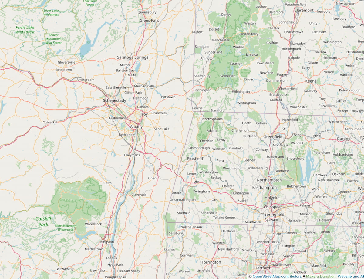
https://www.openstreetmap.org/#map=9/42.7399/-73.2678

On the left (NY) we see clusters of place=town & place=city in the densely populated areas, and since place=village and place=hamlet don’t render at this zoom level, rural areas lack place name labels. This is appropriate and expected. On the right (VT, NH, MA, CT) we see consistent coverage of place name labels as nearly all municipalities have a place=town node whether they are large enough or not. This is not an accurate representation of place name importance. I believe this has happened because the basic administrative division in New England is called a “Town” regardless of population. The Town of Victory has just 70 residents, for example. So it seems mappers have assume that if a place if is called Town of SomeName, then it must be a place=town, not realizing that the definition of the OSM tag is:

An important urban centre, between a village and a city in size

I plan to revert these classification changes at some point, but I feel that this problem needs to be resolved all across New England or it will just re-appear. Anyone up for a region-wide town reclassification project?

4 Likes

I think this effort is overdue. There’s no systematic way to classify population centers within the OSM scheme. I too aligned place names in Rhode Island in this way (i.e. if it’s a city, it got place=city, towns got place=town) and so forth. Obviously this situation is not great for consistent place rendering.

1 Like

But as has been said a number of times, purely basing the “importance” of a place on it’s population count, isn’t really the best way of doing it.

Across a lot of Australia, & in quite a few other places around the World, a “hamlet”, or even “isolated dwelling”, can be the centre of civilisation for several 000 sq km or more, so it is “important”, despite it’s “size”.

Just one that I know of is located on a major highway, & consists of a service station, incorporating a general store + cafe / restaurant & bar, with a couple of houses attached & a camping area out the back. On the highway, the next closest signs of life (a village one way & another service station the other) are 400k / 200 miles away, with nothing in between!

That place should be mapped as at least a town, & probably a city, to denote it’s importance, because it is a vital bit of infrastructure.

1 Like

No worries. Not trying to dictate how populated place classification works in Australia. Just New England, USA. :grinning:

2 Likes

Right: this issue is very much a “this is how we do it around here.” And as New England can be quite confusing with its fauna of place-names (or rather, words in English that denote places, like town, village and hamlet) which overlap between “what people call one of those settlements around here” and “how OSM denotes a populated place of a certain size of population,” there WILL be misunderstandings and hence, the occasional need for “realignments” such as this.

In Oz-Down-Under, you can roll in certain ways that are unique to there, and New Englanders (in OSM) will be fine with it.

This is a topic where a unique combination of OSM tagging (syntax, and by extension, semantics), “local politics” (as in New England, or Australia…) and “what your ‘local’ English-speaking sense of place-names seems to dictate a place is called” (in OSM, perhaps based on local political colloquialisms, perhaps based on “well, we all know what that means in our local dialect of English” all overlap and can and do confuse. And “no,” those are not always the same things. Hence the fuzzy semantics and OSM tagging.

We do OK here, we get better, but certain reminders and dialog (such as in this thread) do help now and then.

I like the definition Tag:place=city - OpenStreetMap Wiki and/or Tag:place=town - OpenStreetMap Wiki

A town should attract people from the surrounding places (villages, hamlet,…) for shopping, (higher) education, … (kind of what was a marketplace in the past centuries).

Though, @Fizzie41 in pretty rural areas there might be differences. Still the place you are talking about would not be a town for me, but rather a village. The population mentioned in the wiki I believe is mainly matching to countries in Europe and might be adjusted to your area.

(To avoid confusion in this post, I’ve appended the registered trademark symbol ® to each occurrence of the word “village®”, “town®”, “city®” that refers to the official designation and applied a monospaced font to each occurrence of village, town, or city that refers to the OSM tag value.)

This happens every now and then in other states too. In Ohio, there’s no formal “town®” designation, only villages® and cities®. However, counties are comprehensively subdivided into townships, which sound like town, so occasionally someone goes around creating a place=town node at the centroid of each township. This is a problem because it buries the actual towns that represent small cities®.

Meanwhile, in neighboring Indiana, there’s no formal “village®” designation, only towns® and cities®. So new mappers sometimes go around upgrading every town to a town, even if there are only a couple hundred residents. Worse still, neighboring Kentucky has only cities® regardless of population – there’s even a city® with zero residents. Sometimes new mappers go around reclassifying all these places as city nodes too.

These changes should be undone. In particular, an Ohio township or a New England town doesn’t strictly represent a human settlement (aka populated place in GNIS terminology or urban area in Census terminology). As it is a “space-filling” administrative unit, its centroid is about as meaningful as the rural location that Michigander mappers will be field surveying next month. Many of these towns contain a focal settlement that might be located near the center and even share the name of the town. That focal point should have a place=village or town or city node depending on its population and regional importance. The node’s population can be derived from the corresponding Census urban area’s population. To pick a random example, Meredith, New Hampshire, has a town® population of 6,662, but only 3,411 live in the Meredith urban area that corresponds to this place node.

Services can be a useful proxy for place classification in rural areas (not so much in the suburbs). Traditionally, one could for example identify a village as having a post office or local newspaper and a town as having a hospital or daily newspaper. With these industries in decline or facing consolidation for economic reasons, they aren’t as useful anymore for classification, though maybe the post office is still an important marker to some extent. Instead, depending on the region, one might say that a village is served by a dollar store while a town is served by a supermarket, taking into account that these stores are often on the outskirts of town, just outside an incorporated area. Perhaps there are other useful proxies.

3 Likes

As usual, excellent post, Minh. If there ARE other useful proxies, I’d encourage them to be discussed, some consensus reached, and added to the appropriate “local usage” notes at our United States/Tags - OpenStreetMap Wiki section (same wiki I previously ref’d). We already begin to do this, saying, for example “A consensus is emerging that a place=village has at least a small commercial landuse area: a market, a fuel station/convenience store, a bank, a post office, etc.” Strengthening these with more “proxies” can only help.

I hesitate to post this since my comments are not about New England, but Stevea brought up the United States/Tags - OpenStreetMap Wiki
The US tags page may need something different for the rural west, possibly for the rural central states too.
This wiki page seems OK, even tho its vague. My quick look at tagging in central & western CO seems consistent with this (there are plenty of internal inconsistencies too)

The US tags page seems too specific & restrictive and written for higher density areas. A large number of places currently tagged as towns would be tagged as village if we followed this.

The anchor in my interpretation is this from the wiki ,

village: A smaller distinct settlement, smaller than a town with few facilities available with people traveling to nearby towns to access these.

The main ‘facilities’ that people go to town for are groceries and hardware.

I don’t think a post office is a good proxy because some places that are no more than a ‘hamlet’ have a post office. A full size grocery store is a good proxy, a ‘town’ has one, a ‘village’ doesn’t.

2 Likes

Yes, I arbitrarily adapted it from Ohio’s tagging guide, and others tweaked it afterwards. The population thresholds originally came from the global place=* articles, though those articles have since been watered down. Don’t take this rubric as gospel; state-specific pages can do a better job of giving mappers guidance on place classification, just as with road classification. Even in Ohio, we make exceptions to these thresholds in the less populous Appalachian counties.

Agree on that and it’s kind of also matching definitions existing in good old Europe since medieval times, where the town was the place where you go for trading. A full size grocery store would be the current equivalent.

1 Like

This is great discussion. If we need to adjust the denoted wiki with more updated, regional perspectives (and it seems like we do, especially about post offices and supermarkets — I agree), let’s do so!

This certainly includes pointing to state-level pages where we can get a finer granularity of specificity. We do this (state-level rather than a “single for all of USA”) for lots of things: highways, rail, etc.

In the wiki, I deleted “post office” from what might promote a hamlet to village; I agree. Y’know, changing wiki is OK. Discussion is OK.

Someone might hone in on better numbers: a village to a town can vary greatly in population. (And then step up with some newer numbers). Or, keep specifying edge cases as proxies between the two, I like hardware stores, sounds about right. This spectrum (chasm?) extends between village and hamlet, too. These are fuzzy edges, we get closer, it seems. There is a sense of “how it renders” that is real about our behavior, I believe, so that aspect can’t be fully ignored. For place names, we’re talking here. And I believe we’re in New England.

New England is a certain part of the world, this planet Earth, and I am proud to call New England part of a strong country, part of an awesome OSM community and downright beautiful. Et cetera.

We’re largely a certain way of distance, and I think we are OK on this one (could it be “healing” itself already?), although I love growth spurts in “data knowledge” in OSM like anybody else. A boundary or border better healing itself is good, especially as it is better (locally speaking). Let’s keep up the good work!

Again, if we need to reduce place=town to lower numbers because that is reality, let the discussion continue and the wiki “heal” itself, too. It’s just flux, kids.

I looked a few of the changesets that bumped the place=* nodes from hamlet|village|etc to place=town or place=city based on their incorporation status and it looks like they were all made by user t2editme about 6 months ago. This user doesn’t seem to respond to changeset comments, but I commented on many of them and invited the user to this thread. The user seems to mostly edit in Maine which has had inflated place=* tagging for some time.

There are so many of these and I believe that they are all incorrect:

And some other questionable change-sets:

Some options:

  1. Find all changesets of this user that modify a place=* tag and revert them.
  2. Find all nodes whose place=* tag was modified by this user and change it back to the value in place before it was edited by this user. (which would avoid losing any possibly valid edits mixed in.
  3. Something else?

I did a similar reclassification in Rhode Island awhile back and I set the place= value of the entire state from top to bottom just by gut feel and with no particular guidance.

I’d really honestly prefer to have some systematic way to handle the place name hierarchy, the same way we’ve done with highway classification. I’m not really sure where to start though. It seems like we’re just kicking the can down the road by not having a coherent system for classifying places.

2 Likes

A little under a year ago I went through Vermont and upgraded various place nodes from place=village to place=town mostly by gut feeling as well. I basically classified settlements as town if there was a grocery store or similar services that clearly served residents of neighboring villages too. I didn’t get to the next step of classifying between village and hamlet. I think it it will basically be something like villages have a few small businesses but not enough to meet all the residents needs and hamlets have either no businesses or just a gas station/convenience store/general store. Residents of both of these place types travel to a nearby town to go shopping. I think this should work pretty well for rural parts of New England, but something entirely different is needed for suburban an metropolitan areas.

As with highway classification, place classification requires systematic planning; our usual focus on on-the-ground verifiability has repeatedly proven inadequate. Some states already have well-defined classification rubrics. But it’s been difficult to come up with a unified, deterministic framework for the whole country because development patterns differ dramatically from region to region. If we start from scratch, I would favor keeping it as simple as possible, focusing on the desired result, and leaving the specific methods and exceptions to regional or state pages.

Nationally, do we want place=city and place=town to have a spatial distribution that reflects the much denser population centers on the coasts? Or do we want to normalize the distribution so that place=city has as much meaning in the Mountain West as it does in the Northeast Corridor? For that matter, should we focus on population and factors that are influenced by population, or should we also factor in commerce, transportation, or even cultural aspects?

These choices greatly affect the heuristics that we’d find useful. At the larger end of the scale, I’ve always started from the principle that a place=city forms the nucleus of a metropolitan area. In other words, a city has suburbs (in the American sense). This suggests that demographic units from the Census Bureau and Office of Management and Budget can help us identify candidates for city and town, if not lower classifications.

The Census Bureau’s urban areas are defined solely by population density, resulting in many urban areas in the Northeast but not so many in the middle of the country. There are too many urban areas to map them to a particular place=* value, but it would probably make sense to look at the smallest urban areas in a state and decide if they should correspond to a hamlet, village, or town.

The OMB’s core-based statistical areas cluster counties by economic and social ties (as measured by the rate of commuters between counties). The result is somewhat more even across states, but counties in the West sometimes aren’t granular enough to set a rule that a place=city must correspond to an MSA’s central city, while counties in New England are so irrelevant that OMB has had to supplement the CBSAs with a parallel system of city and town areas.

At the smaller end of the scale, we’re really at the mercy of each region’s unique development patterns. I don’t think any one rubric can really do justice to the wards of New Orleans, the master-planned “villages” of Irvine, or the colonias of South Texas.

Looking at the OMB’s NECTAs, I can see why you had some difficulty classifying places: all of Rhode Island and beyond constitutes one MSA-equivalent, part of a CSA-equivalent that stretches all the way to Maine. If we end up normalizing the place distribution to please the westerners, you might end up reclassifying a bunch of towns as quarters and neighbourhoods. :stuck_out_tongue:

The Ohio rubric doesn’t even bother to define place=hamlet. There has been zero demand for this tag beyond what the GNIS import used it for (minus the mobile home parks). I suspect there’d be much more demand for a place=hamlet definition in the Northeast, where “hamlet” is a household word.

4 Likes

I think we should aim to classify the relative importance of places within their region just like we did for highway classification. The factors influencing this importance can vary from region to region to account for differences in development patterns. Population numbers are useful, but not as an absolute. Commercial, cultural, and political importance to a region should have greater weight in my opinion.

3 Likes

I’m in favor of reverting these changes. As well as modifications to existing place nodes, I’ve noticed duplicate or near duplicate place nodes that were added. “Town Name” added right next to an existing “North Town Name” for example. It just hasn’t felt worth it to put in the work without clear guidelines and a cleanup process for all of New England though. Otherwise a future mapper will just reinflate Vermont place names again to match the rest of New England.

1 Like

I think you outlined it pretty well above.
Town is the local marketplace, has a full size grocery store & more.
Village has a few retail stores, but lack the full size grocery store
Hamlet, almost nothing, maybe a gas station or a post office
I think that works for the rural rockies and probably the plains states.

City is tougher, but the wiki says

The largest urban settlement or settlements within the territory.

I might look at Colorado with this in mind.

How much does this really matter tho? It looks like Carto and Americana use population to determine the rendering layer.